
What is Bárðarbunga?
Information on the central volcano
There are about 30 known central volcanoes, or volcanic systems, in Iceland. Bárðarbunga, the second highest mountain of Iceland; ca 2000 meters above sea-level, is one of them. The volcano is placed in northwestern Vatnajökull ice cap and therefore covered with ice.
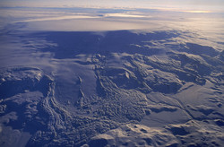
The enormous size and nature of Bárðarbunga was not fully recognized until it was observed in 1973 on an image from a satellite, 800 km above Earth (see below). A caldera in the volcano's crown, 11 km long on the longer side, is covered with approximately 850 m thick glacial ice. Eruptions related to the central volcano can occur anywhere in the caldera, on the sides of the volcano and also in the fissure swarms to the NA and SW of the volcano, for a distance up to 100 km from the central volcano.
Inevitably, immense eruptions and explosive eruptions are a possibility in the system with imminent threat of ice melting in great magnitude causing a huge jökulhlaup (glacial outburst flood). It is presumed that Jökulsárgljúfur and Ásbyrgi (see NLSI leita) were created in such cataclysmic events in prehistoric times. Large jökulhlaup in Kelduhverfi in the 17th century are believed to be related to volcanic activity in Bárðarbunga.
Over the last seven years, seismic activity has been gradually increasing in Bárðarbunga and the fissure swarm north of the volcano. This activity diminished after the Grímsvötn eruption in May 2011, but soon after, the activity started to gradually increase again. The current seismic activity began 16th August 2014.
Detailed chapter in English on Bárðarbunga
Because of the current seismic activity in northwestern Vatnajökull, IMO has been allowed to distribute the chapter Bárðarbunga System, an extract from a much larger work in progress:
In 2011, the Icelandic government approved a proposal by the Minister for the Environment for the preparation of a general risk assessment regarding volcanic eruptions in Iceland. The initial three years have focussed on an appraisal of current knowledge and initial assessment. It will take 15–20 years to complete and require a joint effort by various institutions.
The proposal was based on an estimate made by the Icelandic Meteorological Office in collaboration with the Civil Protection Department of the National Commissioner of the Icelandic Police, the Institute of Earth Sciences at the University of Iceland, the Soil Conservation Service of Iceland and the Icelandic Road Administration.


