
Weather warning - violent storm
A strong gale warning (average windspeed above 20 m/s) is in effect in Iceland this afternoon and for most of tomorrow. A violent storm (average wind speed, above 28 m/s) is expected in the southernmost part as well as in the southeast between 15:00 and 20:00 this afternoon.
Further information
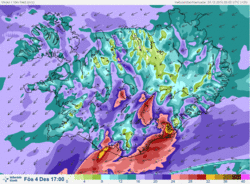
A deep low pressure system (~940 mb) is approaching Iceland from the south.
Wind gusts by Öræfajökul glacier, as well as by Eyjafjallajökull glacier and Mýrdalsjökul glacier can exceed 50 m/s between 15:00 and 20:00 this afternoon. Precipitation will be snow at first, then sleet or rain with ice or wet snow on the roads. Travelling conditions in the south and southeast are expected to be extremely poor.
Elsewhere in Iceland, the winds will increase this afternoon, and by evening northeast gale or strong gale (15-23 m/s) is expected along with blowing snow and later snow when the front moves to the north. Southwest Iceland (including the capital area) will have near gale wind and blowing snow along with intermittent light snow.
On Saturday strong gale with snow and poor visibility is expected in the northern part, while the southern part can expect some isolated snow showers and blowing snow. Overnight and tomorrow the risk of avalanches will increase in the Westfjords and in North-Iceland.
On Sunday winds will moderate and precipitation and clouds will clear, first in West-Iceland. The temperatures will become cooler.
Forecaster on duty
Teitur Arason
Haraldur Eiríksson
Þorsteinn V. Jónsson


