
Severe gale or storm
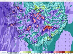
Heaviest rainfall around mountains and ice-caps
A weather warning was issued yesterday afternoon, Tuesday 18th October, forecasting south and southeast severe gale or storm (average wind speed 20 - 28 m/s) in most of Iceland until Thursday morning.
Northern Snæfellsnes has had the strongest winds. Southern Westfjords have had increased water levels with increased possibility of landslides in steep slopes where the precipitation has been most intense.
This evening, winds are increasing again (after a slight decrease this afternoon). Storm or gale (20 - 30 m/s) is forecast for the West and the North; the wind direction is first from the southeast and then the south. Violent wind gusts near mountains could reach 40 m/s or more. In the East, south winds of 15 - 20 m/s are forecast with sharper gusts this evening and into the night.
Precipitation will probably increase in the Southeast this evening but remain the same elsewhere.
Winds will decrease in the West during the night but in the North not until morning.
See also Forecaster's remark and specialist's remarks on hydrology at the relevant front pages.
Rising stream- and river levels are likely on the Snæfellsnes peninsula, at the Hvítá area in the West (both south and west of Langjökull), around the Eyjafjallajökull and Mýrdalsjökull ice-caps and south of the Vatnajökull ice-cap. Travellers are cautioned against fording rivers in these regions.
Reporting floods
With the foreword that safety is most important, reports on
floods are well appreciated. A new web form is still only available in Icelandic but fairly self-explanatory, see further information.


