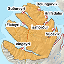
Avalanche bulletin - Northern Westfjords 

-
Fri Apr 19

Considerable danger -
Sat Apr 20

Considerable danger -
Sun Apr 21

Considerable danger
Thick windslabs on firn with a weak boundary. Heavy thaw this weekend and large wet avalanches expected.
Avalanche problems in the area

-
Type
-
HeightAbove 400 m.
-
Aspect
-
Probability
-
Size
After longlasting NE wind and snow drift.
-
Type
-
HeightAll heights
-
Aspect
-
Probability
-
Size
Intense thaw this weekend and large avalanches could release.
Snow layers and snow cover
Thick layered windslab above firn, with a weak boundary between layers. Snow is considered rather stable but people travelling in steep slopes and gullies might trigger avalanches, especially where the weaknesses are shallow, i.e. in convex landscape features and around cliffs or rocks. Snowfall on Friday afternoon with followed by rain until Sunday and heavy thaw. Highly likely that wet avalanches will release, and they could be large.
Recent avalanches
Couple of small avalanches in Kirkjubólshlíð, NW-aspect, fell early last week.
Weather forecast
SE wind and snowfall for a time on Friday afternoon but becoming warmer by evening and turns to rather stiff S/SW wind and starts to rain in all elevations. Considerable rain for a time on Saturday until Sunday morning and ongoing warm weather. Becoming colder on Sunday.


