
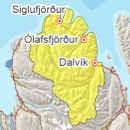
Avalanche bulletin - Tröllaskagi 
-
Thu Apr 25

Moderate danger -
Fri Apr 26
Moderate danger -
Sat Apr 27
Moderate danger
Snow has subsided somewhat in the thaw last weekend and snow has become wet and but not in highest mountains. Snow is affected by diurnal temperature fluctuations and solar radiation. Considerable snow still in high elevations and some slabs persist there.
Avalanche problems in the area
-
Type
-
HeightAll heights
-
Aspect
-
Probability
-
Size
Wet avalanche activity possible.
-
Type
-
HeightAbove 800 m.
-
Aspect
-
Probability
-
Size
After stiff SW wind last weekend in highset mountains.
Snow layers and snow cover
Thaw during last weekend and snow has subsided and stiffened somewhat, but considerable snow is high in mountains and slabs can persist in high elevations. A snowpit in Burstabrekkudalur on Monday gave CT11RP but ECTX, a weak layer by an ice layer on top of old firn persists. Weak layer can persist in high elevations. Warm temperatures during the day and solar radiation affects the top layers of the snow and chance of wet avalanches.
Recent avalanches
Wide slab avalanche fell in Kotafjall in Svarfaðardalur, another smaller one in Skíðadalur on 20.04, another size 2 wet loose avalanche released in Þrastarstaðaskál in Höfðaströnd. Large slab avalanche fell in NW-winds on 15th April in Fljót.
Weather forecast
Light wind for the next days, becoming colder but diurnal temperature fluctuations. Light showers of snow possible on Saturday.


