
Articles
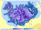
HARMONIE - numerical weather prediction model
HARMONIE is a numerical weather prediction model (NWP) that is non-hydrostatic and convection-permitting. It is operated at 2.5 km horizontal resolution over a domain that covers Iceland and the surrounding seas. At this resolution it is possible to simulate explicitly some processes that are important for clouds and precipitation as well as meteorological phenomena related to up- and downdrafts. In order to simulate the interaction between the atmosphere and the surface, the model takes into account different types of land surface as well as processes in and at the surface.
Read moreAdapting to Change: From Research to Decision-making
Adaptation to climate changes is already high on the agenda in the Nordic and international societies. The conference Adapting to Change: From Research to Decision-making, to be held in Copenhagen 25-27 August 2014, seeks to advance existing common ground between scientists, practitioners and decision-makers and establish new ways forward for informed adaptation; following earlier successful conferences. Deadline for submission of abstracts is 15 April.
The weather in Iceland 2013
The weather in Iceland in 2013 was mainly favorable, however, the spring was harsh in the North and East and the summer was on the dull side in the South and West, with precipitation and cloudiness above average. This was the dullest summer of the new century in this area of the country.
The temperature was unusually high during the first two months but for the rest of the year it was closer to the 1961 til 1990 average.
The weather in Iceland 2012
On the whole the year was a favorable one. However, the first three months were dominated by very changeable and windy weather and southerly and westerly winds that eventually became quite mild. A few damaging windstorms hit the country. September and November were dominated by unfavorable weather.
Read moreInstructions for aurora forecast
Instructions for aurora forecast.

Space weather predictions
Particle flux from the Sun interacts with the Earth's magnetic field and causes short term variations of it. These variations cause the Aurora. In this article, images of the sun made by ESA are shown as well as space weather prediction graphs from NOAA. The Aurora forecast of the Icelandic Meteorological Office is introduced.
Read more
Aurora and the Earth's magnetic field
The Aurora is caused by variations in the magnetic field of the Earth, induced by charged particles called the solar wind. In this article, a figure from NOAA shows variations in the total auroral power around the north pole and the south pole during the past week. The Leirvogur magnetic observatory near Reykjavík is run by the Science Institute of the University of Iceland. It measures magnetic variations, as do many around the world. See real-time observations from Leirvogur for the past 24 hours.
Read more
The weather in Iceland 2011
The year 2011 was warm and the weather mainly favorable in Iceland except for a bad cold spell in late May and June. April and November were unusually warm. At a few stations in the east and northern coastal areas April was warmer than June. This has not happened before in Iceland at any station since the beginning of instrumental recording.
Read more
The weather in Iceland 2010
The weather in Iceland was highly unusual in 2010. This applies especially to the South and West parts of the country where the year was one of the warmest and driest on record and the snowfall was unusually light. The barometric pressure reached the highest annual value on record. The climate was very favourable and windstorms markedly fewer than usual.
Read more
Wind-chill table
The Windchill Temperature index incorporates heat transfer theory (heat loss from the body to its surroundings) during cold and breezy or windy days in order to calculate the dangers from winter winds and freezing temperatures.
Read more
The weather in Iceland 2009
The weather was very favourable in Iceland in 2009. The temperature was well above the 1961 to 1990 mean. This was the driest year in Reykjavík since 1995, but the wettest in Akureyri since 1991.
Read more
High resolution precipitation maps for Iceland
Spatial distribution of precipitation in Iceland has been estimated with 1 km resolution using an orographic precipitation model.
Read more
The ice cap Snæfellsjökull is thinning rapidly
Snæfellsjökull ice cap in western Iceland has been observed to retreat and thin rapidly in recent years according to people living in the neighbourhood of the glacier and travellers in the area. This has now been confirmed by lidar measurements.
Read more
The weather in Iceland 2008
The weather was favourable in 2008. The summer half of the year, May to September was unusually warm in the South and West. October was the only cold month of the year.
Read moreTemperature conversion
The weather in Iceland 2007
During 2007, warmer conditions that have prevailed since 2000 dominated again.
Read moreThe weather in Iceland 2006
The year was generally favourable and warm. In the South and West the temperature was about 1.1°C above the 1961-1990 normal and 1.3 to 1.8°C above normal in the North and East. The average temperature in Reykjavik was 5.4°C. It ranks as the eleventh warmest year in Reykjavik since the inception of continuous measurements there, in 1870.
Read moreSpoken weather forecast
Search
Contact IMO
© Veðurstofa Íslands | Bústaðavegi 7- 9 | 105 Reykjavík | Phone 522 6000 | Fax: 522 6001
Recording 902 0600 | SSN 630908-0350
Contact us | Employees | Terms and conditions | Sitemap


