Avalanche bulletin
Avalanche conditions
The snow pack is generally considered stable and isothermal after freeze thaw cycles in the last days. Small wind slabs may be in the mountains in the East fjords. Large natural avalanches released after warming this week in N-Iceland suggesting a weaknes may still be active although freeze thaw cycles and mild weather continue to strengthen the snowpack.
Written by a specialist at 28 Apr 15:11 GMT
Avalanche bulletins for selected areas 
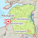
Southwest corner
-
Sun Apr 28

Low danger -
Mon Apr 29
Low danger -
Tue Apr 30
Low danger
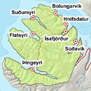
Northern Westfjords
-
Sat Apr 27
Low danger -
Sun Apr 28
Low danger -
Mon Apr 29
Low danger

Tröllaskagi
-
Sat Apr 27

Moderate danger -
Sun Apr 28
Moderate danger -
Mon Apr 29
Moderate danger
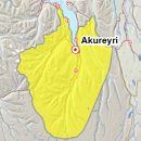
Eyjafjörður (experimental)
-
Sat Apr 27
Moderate danger -
Sun Apr 28
Moderate danger -
Mon Apr 29
Moderate danger
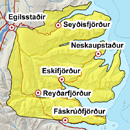
Eastfjords
-
Sun Apr 28
Moderate danger -
Mon Apr 29
Moderate danger -
Tue Apr 30
Moderate danger
Weather forecast in terms of avalanche danger
On Saturday, widely partly cloudy in the northwest and west of the country, some snow or rain showers. Northerly winds 3-10 on Monday, but 8-13 in the Eastfjords. Occasional showers or sleet in the North and East of the country, but fair weather southwestward and warming in the south. Mild weather and gentle winds throughout the country on Tuesday.
Written by a specialist at 28 Apr 15:16 GMT