
Grímsvötn 2010
jökulhlaup - glacier outburst flood in 2010
Jökulhlaup from Grímsvötn subsides - 5 November 2010
The jökulhlaup (glacial outburst flood) from Grímsvötn that began near the end of October is now coming to an end. See thorough description in news on front page.
Assessment - 5 November 2010
Tremor levels at seismic station 'grf' have reduced slightly in the last 24 hours. Discharge measurements in the Gígja river show that the jökulhlaup is waning rapidly. Presently, there are no detectable signs of the beginning of a volcanic eruption at Grimsvötn.
Information in status report nr. 5 issued collectively by the Icelandic Meteorological Office and the Institute of the Earth Sciences, University of Iceland, 5 November 2010 at 17:00.
This is the last status report for the Grímsvötn jökulhlaup. If signs of volcanic activity occur, we will resume these reports immediately.
Assessment
Tremor levels at the seismic station on Grímsfjall (grf) have declined considerably. Discharge measurements from the Gígja bridge showed that the jökulhlaup peaked on Wedenesday 3nd November between 13:00 and 14:00 GMT; at this time, the maximum discharge was ~2,600 m3/s. Electrical conductively levels in Gígja river remain high, signifying continued drainage of meltwater from Grímsvötn. Presently, there are no detectable signs of the beginning of a volcanic eruption at Grimsvötn.
Further information in status report nr. 4 issued collectively by the Icelandic Meteorological Office and the Institute of the Earth Sciences, University of Iceland, 4 November 2010 at 17:00.
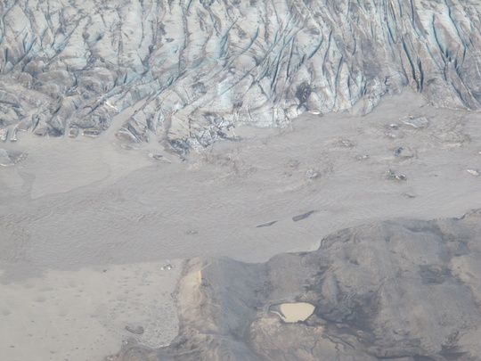
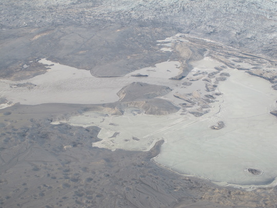
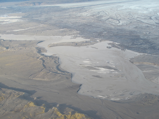
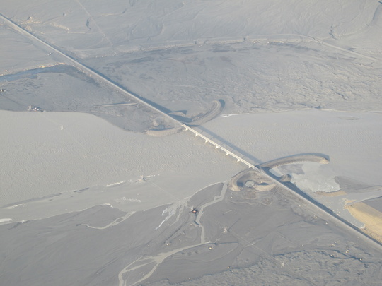
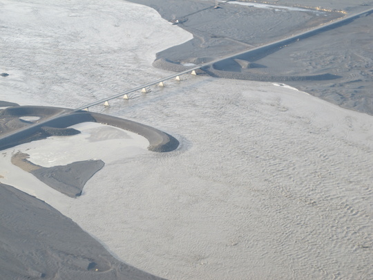
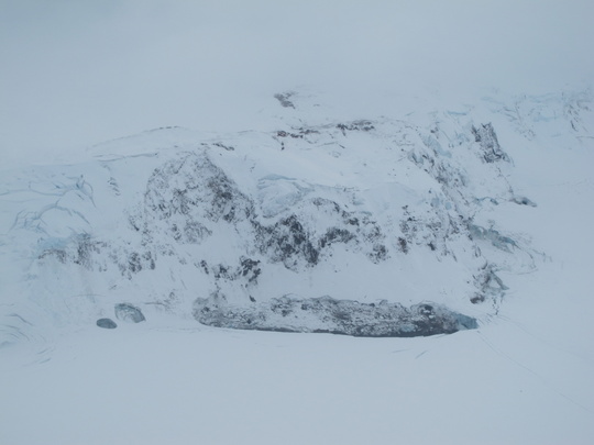
Aerial view
The following photographs were taken 3rd November during scientific flight with the Icelandic Coast Guard (TF-SIF): Matthew J. Roberts and Egill Axelsson, Icelandic Meteorological Office.
Assessment - 3 November 2010
Seismic tremor at Grímsvötn has continued to amplify, indicating enhanced drainage of water from the subglacial lake. Aerial observations over Grímsvötn revealed no signs of volcanic activity.
Discharge continued to increase in the Gígjukvísl river, although it is likely that the jökulhlaup is at, or nearing, maximum discharge. Presently, there are no detectable signs of the beginning of a volcanic eruption at Grímsvötn.
Further information in status report nr. 3 issued collectively by the Icelandic Meteorological Office and the Institute of the Earth Sciences, University of Iceland, 3 November 2010 at 17:00.
Status reports
The Icelandic Meteorological Office and The Institute of the Earth Sciences, University of Iceland, issue collective status reports:
2 November 2010 at 16:00 Status report nr. 2
1 November 2010 at 17:00 Status report nr. 1
Glacier outburst flood - reported 1 November 2010
On October 31, a glacier outburst flood (jökulhlaup*) emerged from beneath the Skeiðarárjökull glacier, a southern outlet of the Vatnajökull ice cap. The floodwaters originate in the subglacial lake Grímsvötn, 50 km upstream from the glacier margin. The lake has been a source of such floods for centuries, but the size of the floods has varied greatly. The present flood is small and no threat to roads and bridges is imminent.
The graph below shows data from a hydrometric station in the river Gígjukvísl Oct. 31 - Nov. 1. 2010.
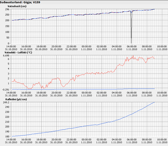
Observations on the bridge over the river Gígjukvísl, which drains part of the glacier, confirmed a steady water level increase that indicated the onset of a jökulhlaup (see top part of graph). Measurements between 2 and 3 PM on Oct. 31 indicated a discharge of 143 m3/s (cubic meters per second) and the water was confined to a narrow part of the channel. Between 9 and 10 AM on November 1, the discharge had increased to 455 m3/s, filling most of the river channel underneath the bridge.
The automated hydrometric station at Gígjukvísl shows that the water level has increased by 1 metre during 20 hours (from 14 PM Oct. 31 to 10 AM Nov. 1). Since the floodwaters dig into the river bed, spread out and frequently change their course it must be kept in mind that the water level measured at a fixed location can only be viewed as an indicator of discharge. More extensive and repeated measurements at several places are therefore needed during jökulhlaups to determine the actual size of the flood.
The electric conductivity of the river water has increased considerably (see the lowest of the 3 graphs). This indicates that geothermal fluids originating in the volcanic system beneath Grímsvötn have mixed with the subglacial lake waters and now form a component of the floodwater.
The graph in the middle shows the water temperature (blue curve) and the air temperature (red curve). The water temperature is very close to the melting point whereas the air temperature curve reflects the diurnal variation.
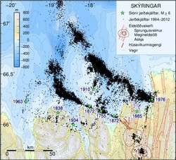
An earthquake of magnitude 3.0 on the Richter scale occurred underneath the Grímsfjall mountain in Vatnajökull on the night before first indications of the jökulhlaup were observed. Grímsfjall is situated adjacent to the Grímsvötn subglacial lake (the source of the flood), and earthquakes and other tectonic movements associated with flooding are recorded by instruments on the mountain. Activity has subsided today.
Scientists will continue to monitor events in Grímsvötn and beneath Skeiðarárjökull very closely as the jökulhlaup progresses in the coming days, see additional information compiled during a sequence of events in 2004.
* Note: The Icelandic word jökulhlaup is widely used in the international geoscience literature for events of this kind; i.e. sudden outburst of floodwaters from subglacial or marginal lakes.


