
Home-page - Icelandic Meteorological Office
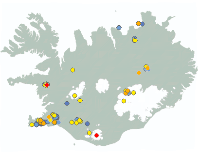
Weather forecast
Weather forecast for the next 24 hours
Northeasterly or variable winds 3-8 m/s.
Intermittent light rain or drizzle in the south and southeast. Scattered showers in other places. Possible fog along the north and east coast.
Calm variable winds tomorrow. Intermittent rain in the west but showers elsewhere. Temperatures of 12 to 20 degrees C, warmest inland.
Forecast made 18.07.2025 18:34
Forecaster's remarks
Volcanic haze has formed under ideal conditions, light wind, humidity, and sunshine and has been observed widely, especially in the North and West of Iceland.
The weather forecast for the coming days indicates light winds, so volcanic haze may continue to be noticeable in some areas.
Prepared by the meteorologist on duty 18.07.2025 18:34
If the map and the text forecast differs, then the text forecast applies
Forecast for station - 1
Forecast for station - 2
Forecast for station - 3
Forecast for station - 4
Forecast for station - 5
Maximum wind in Iceland today
| Lowlands | |
|---|---|
| Highlands | |
|---|---|
Maximum and minimum temperature in Iceland today
| Lowlands | |
|---|---|
| Highlands | |
|---|---|
Maximum precipitation in Iceland today
| Lowlands | |
|---|---|
| Highlands | |
|---|---|
Maximum wind in Iceland during the last hour
| Lowlands | |
|---|---|
| Highlands | |
|---|---|
Maximum and minimum temperature in Iceland during the last hour
| Lowlands | |
|---|---|
| Highlands | |
|---|---|
Maximum precipitation in Iceland during the last hour
| Lowlands | |
|---|---|
| Highlands | |
|---|---|
Preliminary results
Earthquakes
Earthquakes during last 48 hours. at 18 Jul 23:00 GMT

Biggest earthquakes during the last 48 hours
| Size | Time | Quality | Location |
|---|---|---|---|
| 2.6 | 18 Jul 07:02:19 | Checked | 1.9 km N of Krýsuvík |
| 2.4 | 17 Jul 13:53:43 | Checked | 2.2 km N of Krýsuvík |
| 2.0 | 17 Jul 05:21:02 | Checked | 3.6 km SW of Hrómundartindi |
Specialist remark
Eruption started on Sundhnúksgígaröð NE of Stóra Skógfell at 03:54 the 16th of July. The eruption is ongoing, but its activity and tremor have decreased. The main activity is concentrated around the center of the fissure that opened on July 16th. More Info.
Volcanic haze covers the Western and Northern parts of Iceland. Forecasts predict ongoing pollution over the weekend. Sensitive individuals should stay inside and babies should not sleep outside. more info.
Written by a specialist at 18 Jul 19:46 GMT
Week overview -
Earthquake activity throughout the country is described in a weekly summary that is written by a Natural Hazard Specialist. The weekly summary is published on the web every Tuesday. It covers the activity of the previous week in all seismic areas and volcanic systems in the country. If earthquake swarms are ongoing or significant events such as larger earthquakes have occurred during the week, they are specifically discussed. More
Hydrology
Average flow and temperature last 24 hours
| River | Place | Flow | Water temperature |
|---|
Remarks of a specialist
Increased run-off from glaciers is expected today and in the coming days due to warm temperatures. Travelers are advised to show caution around glacial rivers and to keep in mind that fords and rivers can become impassable.
Due to malfunction we have turned off the service publishing hydrological data on the map. Instead see the data using our Real-time monitoring system.
Written by a specialist at 17 Jul 13:17 GMT
Avalanches
Avalanche bulletins for selected areas
The avalanche bulletin is at a regional scale. It does not necessarily represent avalanche danger in urban areas.
| Region | N/A | N/A | N/A |
|---|---|---|---|
|
Southwest corner
|
|
|
|
|
Northern Westfjords
|
|
|
|
|
Tröllaskagi
|
|
|
|
|
Eyjafjörður (experimental)
|
|
|
|
|
Eastfjords
|
|
|
|
News
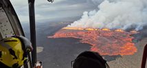
An eruption has started on Sundhnúksgígaröð crater row
Updated at 17:30
The hazard assessment map has been updated. The eruptive fissure at Sundhnúksgígaröð has lengthened while lava flow has decreased. Seismic activity and tremor have declined, but gas pollution and wildfires remain ongoing.
Read more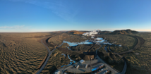
Continued Uplift in Svartsengi
Update July 15
Uplift and earthquake activity are ongoing in the Svartsengi area, with stable activity levels in recent weeks.
No substantial changes have been detected in measurements that would prompt a reassessment of the hazard level. However, continued magma accumulation could increase the likelihood of a magma intrusion or volcanic eruption in the coming autumn.
Read more
A jökulhlaup from Mýrdalsjökull into the rivers Leirá Syðri and Skálm
The flood is subsiding, and water level and conductivity are now approaching normal values in Skálm.
The flood reached its peak the night before last. IMO´s specialists continue to observe the area
Read moreAnalysis: Climate change made the May heatwave more likely and more intense
In May 2025, an unusually intense heatwave struck Iceland and eastern Greenland, breaking numerous temperature records. On 15 May, Iceland's national May temperature record was set at 26.6°C at Egilsstaðir Airport, with several locations recording temperatures up to 13°C above the monthly average.
A new international analysis by the World Weather Attribution group shows that human-induced climate change made this heatwave around 40 times more likely and, on average, three degrees Celsius hotter than it would have been without global warming. The study also suggests that if global temperatures rise by 2.6°C, such heatwaves could become at least twice as frequent and two degrees hotter.
Read more
The most significant May heatwave ever recorded in Iceland
Temperatures
reached or exceeded 20°C at several weather stations for 10 consecutive
days.
May temperature records were repeatedly broken at weather stations across the country.
A new national May temperature record of 26.6°C was set at Egilsstaðir Airport on May 15th.
Read moreShort articles
Safetravel in winter
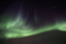
Increasingly, tourists come in winter to enjoy the beauty of the northern lights. Safety while travelling is always crucial, especially in winter conditions.
The web-site Safetravel is run by ICE-SAR in order to minimize the risk of accidents in travelling and tourism in Iceland.
Thorough information on safe travelling can be found there. The 112 Iceland app can be downloaded and your travel plan can be left in safe hands before you go. Additionally, a personal location beacon can be rented at two pick-up places.
Read moreNew publications and research
- Guðrún Nína Petersen (2025). Alviðruhamrar - Meteorological conditions
- Michelle Parks, Freysteinn Sigmundsson, Vincent Drouin, Ásta R. Hjartardóttir, Halldór Geirsson, Andrew Hooper, Kristín S. Vogfjörð, Benedikt G. Ófeigsson, Sigrún Hreinsdóttir, Esther H. Jensen, Páll Einarsson, Sara Barsotti & Hildur M. Friðriksdóttir. (2023).
- Sahar Rahpeyma, Benedikt Halldórsson, Birgir Hrafnkelsson & Atefe Darzi. (2023). Frequency-dependent site amplification functions for key geological units in Iceland from a Bayesian hierarchical model for earthquake strong-motions.
- Sara Klaasen, Solvi Thrastarson, Yesim Cubuk-Sabuncu, Kristín Jónsdóttir, Lars Gebraad, Patrick Paitz & Andreas Fichtner. Subclacial volvano monitoring with fiber-optic sensing: Grímsvötn, Iceland. (2023).
- Ismael Vera Rodriquez, Marius P. Isken, Torsten Dahm, Oliver D. Lamb, Sin-Mei Wu, Sigríður Kristjánsdóttir, Kristín Jónsdóttir, Pilar Sanchez-Pastor, John Clinton, Christopher Wollin, Alan F. Baird, Andreas Wuestefeld, Beat Booz, Eva P.S.Eibl, Sebastian Heimann, Bettina P. Goertz-Allmann, Philippe Jousset, Volker Qye, Vala Hjörleifsdóttir, Anne Obermann. (2002).
- Lamb, O.D., Gestrich, J.E., Barnie, T.D., Jónsdóttir, K., Ducrocq, C., Shore, M.J., Lees, J.M., Lee, S.J (2022). Acoustic observations of lava fountain activity during the 2021 Fagradalsfjall eruption, Iceland. Bull Volcanol 84, 96. doi.org/10.1007/s00445-022-01602-3
- Freysteinn Sigmundsson, Michelle Parks, Andrew Hooper, Halldór Geirsson, Kristín S. Vogfjörd, Vincent Drouin, Benedikt G. Ófeigsson, Sigrún Hreinsdóttir, Sigurlaug Hjaltadóttir, Kristín Jónsdóttir, Páll Einarsson, Sara Barsotti, Josef Horálek & Thorbjörg Ágústsdóttir (2022). Deformation and seismicity decline before the 2021 Fagradalsfjall eruption. Nature 609, 523–528. doi.org/10.1038/s41586-022-05083-4
Search
Contact IMO
© Veðurstofa Íslands | Bústaðavegi 7- 9 | 105 Reykjavík | Phone 522 6000 | Fax: 522 6001
Recording 902 0600 | SSN 630908-0350
Contact us | Employees | Terms and conditions | Sitemap


