Home-page - Icelandic Meteorological Office
Weather forecast
Weather forecast for the next 24 hours
South winds, 8-15 m/s, but stronger winds locally in the northwest part. Intermittent drizzle or rain in the south and west part, but mostly dry elsewhere. Temperatures 6 to 13 deg. C, warmest in East-Iceland.
South 10-18 m/s by morning and considerable rain in the south and west parts, windier for a period in the north, but mainly dry in the northeast. Turning to southwest 8-15 m/s with light rainshowers tomorrow afternoon, first in the west. Gradually falling temperatures, 2 to 10 C tomorrow evening.
Forecast made 02.11.2026 18:09
Forecaster's remarks
Expecting strong south and southwest wind gusts in the northwest parts, mainly tomorrow morning, and into the late afternoon. Travellers drive carefully, mainly if vehicles are suseptible to winds.
Prepared by the meteorologist on duty 02.11.2026 18:09
If the map and the text forecast differs, then the text forecast applies
Forecast for station - 1
Forecast for station - 2
Forecast for station - 3
Forecast for station - 4
Forecast for station - 5
Maximum wind in Iceland today
| Lowlands | |
|---|---|
| Highlands | |
|---|---|
Maximum and minimum temperature in Iceland today
| Lowlands | |
|---|---|
| Highlands | |
|---|---|
Maximum precipitation in Iceland today
| Lowlands | |
|---|---|
| Highlands | |
|---|---|
Maximum wind in Iceland during the last hour
| Lowlands | |
|---|---|
| Highlands | |
|---|---|
Maximum and minimum temperature in Iceland during the last hour
| Lowlands | |
|---|---|
| Highlands | |
|---|---|
Maximum precipitation in Iceland during the last hour
| Lowlands | |
|---|---|
| Highlands | |
|---|---|
Preliminary results
Earthquakes
Earthquakes during last 48 hours. at 02 Nov 22:10 GMT


Biggest earthquakes during the last 48 hours
| Size | Time | Quality | Location |
|---|---|---|---|
| 3.3 | 01 Nov 20:28:57 | Checked | 170.7 km NNE of Kolbeinsey |
| 1.8 | 02 Nov 03:49:26 | Checked | 72.4 km W of Kolbeinsey |
| 1.6 | 02 Nov 17:27:14 | 50.0 | 6.9 km ENE of Bárðarbunga |
| 1.5 | 01 Nov 03:14:05 | 50.0 | 0.3 km WSW of Skjaldbreið |
| 1.4 | 01 Nov 01:34:41 | Checked | 7.9 km ENE of Bárðarbunga |
| 1.3 | 01 Nov 01:34:41 | Checked | 5.7 km ESE of Bárðarbunga |
Week overview -
Earthquake activity throughout the country is described in a weekly summary that is written by a Natural Hazard Specialist. The weekly summary is published on the web every Tuesday. It covers the activity of the previous week in all seismic areas and volcanic systems in the country. If earthquake swarms are ongoing or significant events such as larger earthquakes have occurred during the week, they are specifically discussed. More
Hydrology
Average flow and temperature last 24 hours
| River | Place | Flow | Water temperature |
|---|
Remarks of a specialist
Rising water levels are expected in rivers and streams in the western part of the country and by Mýrdalsjökull over the next few days.
Due to malfunction we have turned off the service publishing hydrological data on the map. Instead see the data using our Rauntímavöktunarkerfi.
Written by a specialist at 02 Nov 16:20 GMT
Avalanche forecasts are now published on Icelandic Met Office’s new website:
New avalanche pages on gottvedur.is/en
News from the Icelandic Met Office’s landslide monitoring service are now published on a new site for landslide warnings on gottvedur.is
News
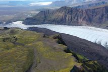
Renewed movement detected at Svínafellsheiði
The monitoring system installed at Svínafellsheiði to track movement in the slope has detected movement since 23 September. This is the first movement to be detected so clearly since monitoring began in autumn 2018. The movement remains slow, and it is not yet possible to predict how it will develop. The Icelandic Meteorological Office has increased monitoring.
Read more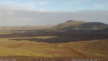
Situation on the Reykjanes Peninsula
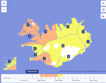
Deep low approaching Iceland, bringing gales, rain and blizzard conditions
A deep low will approach Iceland tonight, bringing easterly gales and considerable precipitation tomorrow morning. Northerly winds will bring blizzard conditions to northwestern Iceland in the afternoon, spreading eastwards overnight. The weather will ease on Thursday. Keep up to date with weather warnings.
Read moreNew risk assessment for people's safety in Grindavík available on the municipality's website
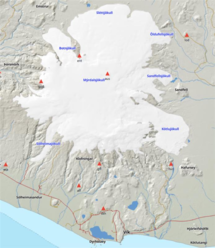
Increased electrical conductivity and gas pollution at Múlakvísl
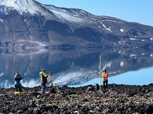
Measurements show that uplift at Askja has ceased
Measurements by the lake in Askja. Fieldwork in the area was completed this week, and the results indicate that the uplift episode that began in 2021 has ended.
Read moreShort articles
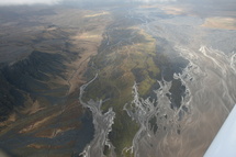
Flood warning system and jökulhlaups - Eyjafjallajökull
Jökulhlaups (glacier outburst floods) are more common in Iceland than elsewhere in the world because of the interaction of volcanoes with glaciers. The greatest jökulhlaups from the subglacial Katla volcano are among the largest floods that humans have witnessed.
Read moreNew publications and research
- Guðrún Nína Petersen (2025). Alviðruhamrar - Meteorological conditions
- Michelle Parks, Freysteinn Sigmundsson, Vincent Drouin, Ásta R. Hjartardóttir, Halldór Geirsson, Andrew Hooper, Kristín S. Vogfjörð, Benedikt G. Ófeigsson, Sigrún Hreinsdóttir, Esther H. Jensen, Páll Einarsson, Sara Barsotti & Hildur M. Friðriksdóttir. (2023).
- Sahar Rahpeyma, Benedikt Halldórsson, Birgir Hrafnkelsson & Atefe Darzi. (2023). Frequency-dependent site amplification functions for key geological units in Iceland from a Bayesian hierarchical model for earthquake strong-motions.
- Sara Klaasen, Solvi Thrastarson, Yesim Cubuk-Sabuncu, Kristín Jónsdóttir, Lars Gebraad, Patrick Paitz & Andreas Fichtner. Subclacial volvano monitoring with fiber-optic sensing: Grímsvötn, Iceland. (2023).
- Ismael Vera Rodriquez, Marius P. Isken, Torsten Dahm, Oliver D. Lamb, Sin-Mei Wu, Sigríður Kristjánsdóttir, Kristín Jónsdóttir, Pilar Sanchez-Pastor, John Clinton, Christopher Wollin, Alan F. Baird, Andreas Wuestefeld, Beat Booz, Eva P.S.Eibl, Sebastian Heimann, Bettina P. Goertz-Allmann, Philippe Jousset, Volker Qye, Vala Hjörleifsdóttir, Anne Obermann. (2002).
- Lamb, O.D., Gestrich, J.E., Barnie, T.D., Jónsdóttir, K., Ducrocq, C., Shore, M.J., Lees, J.M., Lee, S.J (2022). Acoustic observations of lava fountain activity during the 2021 Fagradalsfjall eruption, Iceland. Bull Volcanol 84, 96. doi.org/10.1007/s00445-022-01602-3
- Freysteinn Sigmundsson, Michelle Parks, Andrew Hooper, Halldór Geirsson, Kristín S. Vogfjörd, Vincent Drouin, Benedikt G. Ófeigsson, Sigrún Hreinsdóttir, Sigurlaug Hjaltadóttir, Kristín Jónsdóttir, Páll Einarsson, Sara Barsotti, Josef Horálek & Thorbjörg Ágústsdóttir (2022). Deformation and seismicity decline before the 2021 Fagradalsfjall eruption. Nature 609, 523–528. doi.org/10.1038/s41586-022-05083-4
Search
Contact IMO
© Veðurstofa Íslands | Bústaðavegi 7- 9 | 105 Reykjavík | Phone 522 6000 | Fax: 522 6001
Recording 902 0600 | SSN 630908-0350
Contact us | Employees | Terms and conditions | Sitemap