
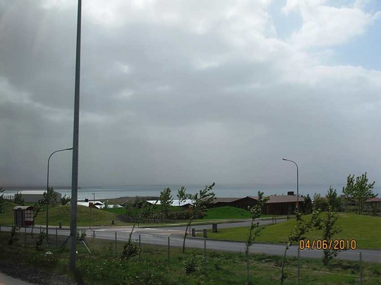
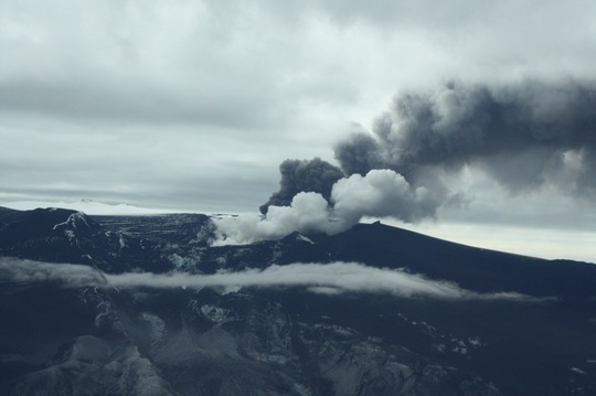
Update on activity in Eyjafjallajökull 2010
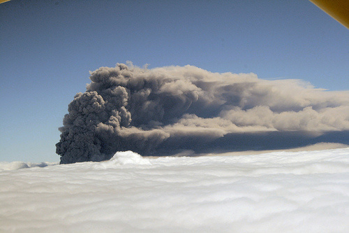
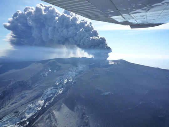
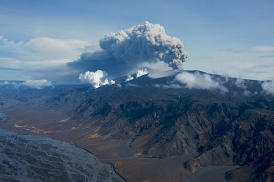
Eruption in Eyjafjallajökull, Iceland
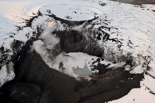
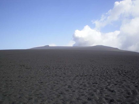
Craters in autumn
This photo was taken at sunrise on a Saturday morning in October, by Ólafur Sigurjónsson who lives in Forsæti III nearby and has done frequent flying across the eruptive area.
Assessment - 23 June 2010 09:15
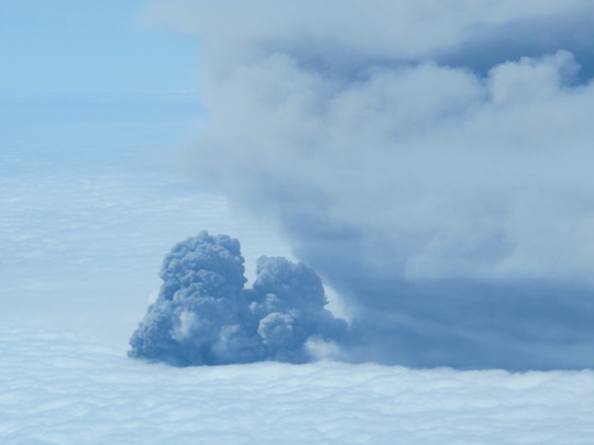
Very little activity is at Eyjafjallajökull volcano. Small ash clouds are seen occasionally, they disappear again in some minutes. Water accumulation in the crater is slow as the ice is no longer in contact with hot material. GPS measurements show slight movements towards the mountain except at Austmannsbunga in Mýrdalsjökull, which shows movement towards southwest. No obvious explanation has been found for this movement.
Status reports from the Icelandic Meteorological Office and the Institute of Earth Sciences will no more be sent on regular basis, but only if something notable is observed.
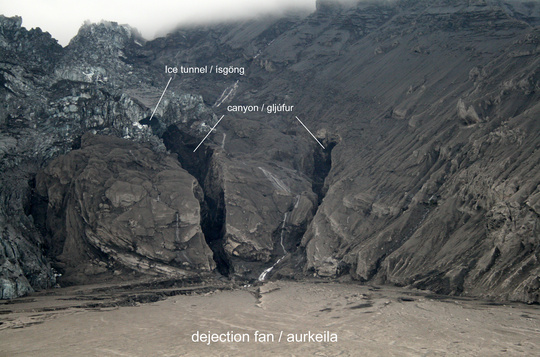
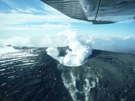
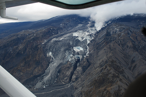
Ice tunnel in Gígjökull - 23 June 2010
Inspection of a photo from Gígjökull since 11 June shows an ice tunnel above the main canyon in the palagonite, which has been deepened and enlarged by the glacial bursts on April 14-15. Another canyon has formed to the west.
A quick and rough interpretation of the pictures suggests that the head of the sedimentary fan (upper part starting at the foot of both canyons) is presently at an elevation close to 340 m a.s.l., which is roughly 50 meters more than the elevation of the lake before the eruption (according to Digital Terrain Model, DTM, from ISOR).
Assessment - 17 June 2010 10:00
There is a wall of ice at the eastern, southern and western sides of the crater lake. On the northern side a tephra wall rises 20 meters above the water. The ice walls at the southwestern corner of the crater are melting, i.e. at the site of the vent that was active 4 - 6 June. The rate of melting is assumed to be about one cubic meter per second.
Details on the volume of the lake, and possible flooding from it, in a status report issued collectively by the Icelandic Meteorological Office and the Institute of Earth Sciences on Tuesday 15 June 2010 at 17:00.
Assessment - 14 June 2010 10:40
Details on the crater lake (described below), and on a mud flow last week in river Svaðbælisá, in a status report issued collectively by the Icelandic Meteorological Office and the Institute of Earth Sciences on Friday night 11 June 2010 at 23:00, where it says that no magma is being erupted and that the activity is confined to steaming.
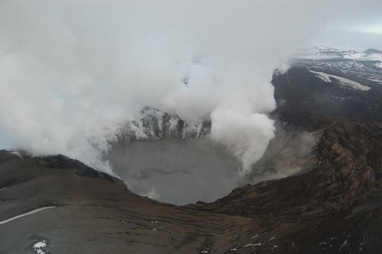
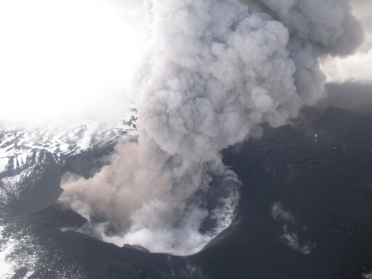
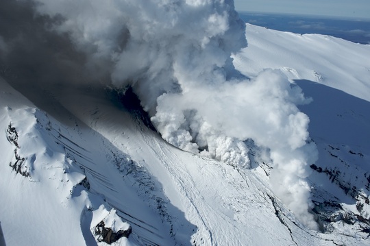
A lake has formed in the crater - 11 June 2010 19:00
Scientists flew over Eyjafjallajökull this morning and saw that a lake has formed in the crater. Possibly, some degassing of magma still occurs in a small path located at the western or soutwestern rim of the crater, see brownish veils at the right hand side of the photograph below. Steam rises from the surface of the water, mostly at the northern edge.
Assessment - 10 June 2010 16:50
The eruption site has not been visible today.
A few small, shallow earthquakes have been recorded beneath the top crater in the last few days. Deflation of the volcano has been slow and continuous for the last two weeks. A small increase in tremor was observed on Monday evening and higher steam clouds were seen at the same time on a web-camera. The clouds were white and contained little or no ash.
Details in a status report issued collectively by the Icelandic Meteorological Office and the Institute of Earth Sciences today at 15:00. The volcano is still monitored closely.
Assessment - 7 June 2010 14:40
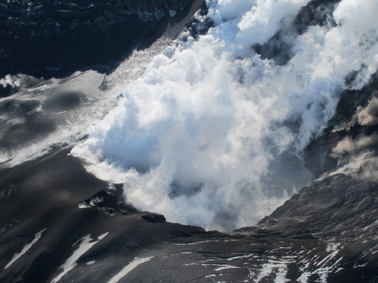
Some eruptive activity is still in the western side of the crater. Magma explosions occur off and on producing ash, which falls near the crater. This explosive activity is accompanied by an abrupt increase in tremor. White steam clouds have reached a height of 6 km following these explosions. We continue to monitor the volcano closely.
In the western part of the crater, a new crater has formed at the site of explosive activity. Tremor pulses late 6 June accompanied steam plumes from this new crater. The plumes and explosions are small. Caving in of lava in the conduit can be heard between explosions. Only a part of the new active crater has been seen due to the steam. The glacial ice at the top is advancing rapidly to the Gígjökull outlet glacier.
In the afternoon of 4 June an increase in seismic tremor was recorded at seismic stations around the volcano, but decreased again in the evening. Small pulses of tremor were recorded off and on during the night. At around 0900h on 5 June the tremor reached a maximum before decreasing again. An increase was recorded late 6 June for a short time and small pulses were recorded last night. The tremor has been predominantly at high frequencies. A few small, shallow earthquakes have been recorded beneath the top crater in the last few days.
Details in a status report issued collectively by the Icelandic Meteorological Office and the Institute of Earth Sciences today at 11:00. See also status report from 4 June 12:00.
Assessment - 1st June 2010 17:20
Clouds and mist have covered the summit of the volcano both yesterday and today. At 8 o'clock this morning, a white cloud was seen at 2 km a.s.l. on web cameras. Winds of up to 10 m/s are blowing from the east. There was widespread drifting of existing ash in southwest Iceland, both yesterday and today; and high concentration of airborne dust was recorded in Reykjavík yesterday, at noon and again at midnight.
Details in a status report issued collectively by the Icelandic Meteorological Office and the Institute of Earth Sciences today at 15:00. The volcano will continue to be monitored closely as before. Next assessment will be made on Friday 4th June.
Assessment - 28 May 2010 15:30
Clouds have covered the top of the mountain this morning and therefore the plume has not been seen on web-cameras. Light wind from ENE.
The Institute of the Earth Sciences made an expedition to the summit of Eyjafjallajökull yesterday, Thursday 27 May. Tephra thickness in and around the eastern half of the craters was measured and found to be up to 40 m thick. Intense steam rises up from the craters, with occasional small ashy explosions. The noise of intense boiling and or degassing is heard from the craters. The crater rim is coated with fine ash that extends 20 m from the edge. Strong smell of sulfur around the craters.
At 20:45 the steam plume was measured to be at the altitude of 2.8 km. There is still a considerable amount of steam coming from the crater. The tremor is still higher than before the onset of the eruption, and small tremor pulses have been detected on the lowest frequency. Rain has prevented the ash to be blown up from the ground around the volcano.
Details in a status report issued collectively by the Icelandic Meteorological Office and the Institute of Earth Sciences today at 12:00. The volcano will continue to be monitored closely as before. Next assessment will be made on Tuesday 1st June.
Assessment - 26 May 2010 18:10
There is still a considerable amount of steam coming from the crater. According to a webcamera in the morning, the plume was estimated at 2 km height a.s.l. (6600 ft). It is heading south with northerly wind.
But in the afternoon visibility has been poor, caused by ash that has been blown up around the volcano. Visibility in Vestmannaeyjar was 1 km and 2 km in Vatnsskarðshólar. Fine ash has been suspended. It does not go high up in the air, but covers the volcano so it can not be seen on webcameras.
Very little changes since yesterday. Since there is little activity, assessment will not be done daily. Next status report will be published on Friday 28th May.
Details in a status report issued collectively by the Icelandic Meteorological Office and the Institute of Earth Sciences 26 May at 17:00.
Assessment - 26 May 2010 09:00
Conditions at the eruption site were similar yesterday at 17:00 as on 24 May, estimated through a webcamera and a flight over the volcano. Blue smog (sulfuric gases) could be seen and a strong smell was felt inside the airplane when flying south of the volcano. A group of scientists went to the crater and they could see a small blast of ash, but mostly it is steam that is formed above the crater that can be seen from distance.
Volcanic tremor was still more than before the eruption and has been rather steady the last couple of days, but small pulses, mostly on the lowest frequency (0.5-1.0 Hz), were detected on the earthquake stations around the volcano. Eleven earthquakes were detected under the volcano yesterday, but 8 earthquakes were detected there 24 May. No significant deformation at sites around Eyjafjallajökull in the last couple of days.
Details in a status report issued collectively by the Icelandic Meteorological Office and the Institute of Earth Sciences 25 May at 17:00.
Assessment - 24 May 2010 15:00
There is still a considerable amount of steam coming from the crater, but no ash can be seen in it. According to a web camera, the steam plume reaches 2 km/6600ft (a.s.l.). Due to light northerly wind, it is heading south.
Conditions at the eruption site are similar to yesterday, estimated through a webcamera. Earthquake activity has decreased since yesterday; only one earthquake has been recorded since midnight. The eruption seems to be dormant.
However, tremor is still higher than before the onset of the eruption, especially in the frequency band 1-2 Hz. Details in a status report issued collectively by the Icelandic Meteorological Office and the Institute of Earth Sciences at 14:00.
Assessment - 23 May 2010 18:00 - Whitsun
The eruption plume is light in colour, contains steam, and is heading south in a light northerly wind. The plume is estimated at 3 km/10,000ft height (a.s.l.). There are no reports of ashfall; no lightning strikes have been detected and no noises reported. Meltwater discharge from Gígjökull is low.
Measurements with a heat camera made from an aircraft gave just under 100°C as the highest temperatures at the crater. The crater could not be observed, due to steam rising from it. No signs of extrusion of magma could be seen. Volcanic tremor is still decreasing and is approaching the level it had before the eruption.
Today, the eruption seems to be dormant. There is still a considerable amount of steam coming from the crater, but no ash can be seen in it. Details in a status report issued collectively by the Icelandic Meteorological Office and the Institute of Earth Sciences at 17:00.
On ashfall - 23 May 2010 11:45
The eruption activity is minimal and therefore no significant ashfall is expected. The volcano is still being monitored and an ashfall forecast will be issued if neccessary.
Assessment - 22 May 2010 16:30
According to reconnaissance flight at 14:00, the plume is estimated at 4km/14,000ft height (a.s.l.). The plume is lightgrey and grey, and a light easterly wind blows it to the west.
No reports of ashfall today; no lightning strikes have been detected since two days ago and there are no reports of noise from the eruption. Meltwater discharge from Gígjökull is small. The eruption is ongoing similar to yesterday with occasional explosions in the crater. Neither crater nor lava is visible due to clouds over the volcano.
About twenty earthquakes have been recorded since midnight, the majority at shallow depths. GPS deformation indicates subsidence of the volcano. Details in a status report issued collectively by the Icelandic Meteorological Office and the Institute of Earth Sciences at 14:00.
Assessment - 21 May 2010 20:45
Observation from inspection flight and other pilot reports show that the eruption plume is light grey, with a small amount of ash and the height is 3-3.5 km/10,000-12,000 ft (a.s.l.). Plume is blown towards northeast and later northwest by light southerly winds.
No reports of ashfall today. Reports from Neðri-Þverá and Hlíðarendakot in Fljótshlíð of bluish gas along the hillsides in some sort of clouds, smelling foul (causing headache when dark in colour).
Volcanic tremor levels have decreased since yesterday evening. However, they rose for two hours this morning, but have since continued to decrease. Over twenty earthquakes have been recorded since midnight, the majority at shallow depths.
The eruption has declined a great deal and the flow of magma into the crater can be roughly estimated as 5 tonnes/s, carried away by a plume that rises 1.5-2 km above the crater. No lava flowing.
The above is based on a status report issued collectively by the Icelandic Meteorological Office and the Institute of Earth Sciences at 19:00.
Assessment - 20 May 2010 18:00
According to radar observations, the plume has been at around 5 km/18,000 ft. today. The volcano has not been visible for two days due to cloudy weather. Ashfall has only been reported at Fljótsdalur, the innermost farm in Fljótshlíð, beginning last night and continuing all day.
Meltwater from the eruption site is still at a low. Water discharge in rivers around the Eyjafjallajökull glacier has decreased again after the increase caused by rainfall yesterday.
Radar images from TF-SIF show no major changes in the ice cauldrons where the cinder cone is forming. The eruption is mainly explosive and almost no lava flows down Gígjökull.
The height of the ash plume has decreased in the last few days which suggests a decrease in magma flow (considerably less than 50 tonns/sec) compared to the flow over the weekend and at the end of last week. Fluctuations in eruption activity and varying ashfall can still be expected.
The above is based on a status report issued collectively by the Icelandic Meteorological Office and the Institute of Earth Sciences at 17:00.
Assessment - 19 May 2010 17:55
According to radar and pilots' observations, the plume has been slightly lower today than yesterday, at 5-6 km (18,000-20,000 ft). Southerly winds prevailed this morning over the volcano, turning to the southwest at 15-18 m/s. The plume drifted northwest early this morning, but then turned north-northeast, and its colour is gray or light gray. The number of lightning strikes has decreased.
Ash has fallen in the south at Flúðir, Fljótshlíð and Rangárþing ytra. Ash has also fallen with rainfall in the north, in Húsavík and Skagafjörður, right before noon.
Heavy rainfall caused swelling of Eyjafjallajökull rivers today. The rain, together with ash from an area of a few square kilometers, resulted in a mudslide in Svaðbæli river. Hydrologists from IMO, and a scientist from IES, gathered samples from the river and also from Skógar river. The discharge at the old bridge over Markarfljót river has not been greater since 15 April. The discharge at Gígjökull is still low.
The plume is up to 5-6 km and drifts to the north-northeast according to reconnaissance flight from the Icelandic Coast Guard this afternoon. The above is based on a status report issued collectively by the Icelandic Meteorological Office and the Institute of Earth Sciences at 17:00.
Assessment - 18 May 2010 18:05
According to radar observations, the eruption plume has been mostly at 7 km (21,000 ft) height. Over the volcano, south and southwesterly winds blow. Near the surface, the wind was easterly, blowing ash from the ground towards west and northwest. The plume is gray and drifting northeast.
Ash has fallen in the Gnúpverjahreppur area, Hrauneyjar and in the northeast and east part of Iceland (from Laugar in S-Þingeyjarsýsla to Seyðisfjörður). Higher aerosol concentrations have been recorded in Reykjavík around midday, due to ash drifting over the area. More than 70 lightning strikes from midnight to midday have been detected.
A powerful explosive eruption is ongoing and the height of the plume suggests that the eruption rate is over 200 tonnes per second.
Details in status report issued collectively by the Icelandic Meteorological Office and the Institute of Earth Sciences at 17:00.
Assessment - 17 May 2010 18:05
The height (a.s.l.) of the eruption plume is about 6-7 km according to radar, occasionally pulsating to 9 km (27,000 ft). Winds around the volcano are slightly increasing, resulting in lower plume height. The plume is drifting east and is dark-gray.
Ash has fallen in the Gnúpverjahreppur area, on the road to Sultartangi power station and in the Biskupstungur area (very fine particled and gray). Constant lightning has been detected, up to 10 flashes per hour. The ash plume rises straight up from the site.
The volcanic activity is explosive, but there are indications that it has somewhat lessened since the maximum on 13 May. Considerable ashfall is in the nighbouring communities and is expected to continue. Fluctuations in the strength of the eruption and in ashfall can still be expected. Details in status report issued collectively by the Icelandic Meteorological Office and the Institute of Earth Sciences at 17:00.
Assessment - 16 May 2010 19:15
The eruption plume is gray and the height is mainly ~ 7 - 9 km / 24,000 - 30,000 ft. It is heading southeast and east-southeast. There wind is calm over the volcano, with wind speed ~10 m/sec at height over 7 km / 24,000 ft.
Ash fall is reported southeast of Eyjafjallajökull, from Skógar to Pétursey on Mýrdalssandur.
No major changes are seen in the activity. The ash cloud has been of variable height the last days and is higher today than yesterday, influenced by the calm weather. Unusually many lightning have been detected. Presently there are no indications that the eruption is about to end.
Details in status report issued collectively by the Icelandic Meteorological Office and the Institute of Earth Sciences at 17:00.
Assessment - 15 May 2010 17:25
The eruption plume is gray and the height is mainly ~ 6 - 7 km / 21,000 - 24,000 ft, occasionally reaching 8 km / 27,000 ft. It is heading southwest and later south.
Ashfall has been reported south of Eyjafjallajökull and ashdrift southeast of Eyjafjallajökull.
An earthquake swarm started beneath Eyjafjallajökull just before midnight. In the period between 23:54 and 02:45, more than thirty earthquakes were located at depth greater than 20 km and magnitude less than Ml 2. A few more earthquakes were detected until morning.
No major changes are seen in the activity, the ash cloud is slightly higher than yesterday. Presently there are no indications that the eruption is about to end.
Details in status report issued collectively by the Icelandic Meteorological Office and the Institute of Earth Sciences at 15:00.
Assessment - 14 May 2010 18:55
The height of the eruption plume is mainly ~7 km (24,000 ft); heading west and later southwest and the colour is grey. Ashfall was reported from Vestmannaeyjar islands, Rangárþing eystra and in Reykjavík.
More than 50 lightning strikes were recorded on the ATDnet during the last 24 hours, thereof ten between 4 and 5 o'clock this morning. No major changes are seen in the activity. Presently there are no indications that the eruption is about to end.
Details in status report issued collectively by the Icelandic Meteorological Office and the Institute of Earth Sciences at 17:00.
Assessment - 13 May 2010 19:45
The eruption plume is gray and heading southeast. The height is mainly 6 km (20,000 ft) but has reached up to ~ 9 km (30,000 ft). Wind is calm over the eruption site and unstable air south of it, which does affect the height of the ash cloud.
Ashfall has been reported since 6 o'clock this morning from various farms in the vicinity; the ash is somewhat finer today than yesterday. Twenty lightnings were recorded on the ATDnet since last night (UK Met Office). Only the upper part of the ash cloud and the lower part of Eyjafjallajökull could be seen during air surveillance, see photos below; ordinary clouds obscured the view.
No major changes are seen in the activity, although the ash plume has increased in hight since yesterday. Presently there are no indications that the eruption is about to end. The above is based on a status report issued collectively by the Icelandic Meteorological Office and the Institute of Earth Sciences at 16:00.
Assessment - 12 May 2010 18:15
Ashfall was reported in Vík í Mýrdal and in Meðalland and ash mist was reported in Álftaver. Several lightnings were recorded on the ATDnet (UK's National Weather Service) since five o'clock yesterday until noon today; see IMO's map of lightning locations for the past seven days, based on that data.
No major changes are seen in the activity. The ash plume has slightly decreased since yesterday and is heading east-souteast. Water discharge at Gígjökull is low. Presently there are no indications that the eruption is about to end. The above is based on a status report issued collectively by the Icelandic Meteorological Office and the Institute of Earth Sciences at 15:00.
Various photographs of Eyjafjallajökull, since volcanic activity began, are presented in another article.
Assessment - 11 May 2010 18:45
The grey eruption plume is heading southsoutheast and it's height is similar to previous days. Observations from air and web cameras show similar activity to yesterday. In the afternoon there was an increase in explosive activity, giving darker and slightly higher plume.
No major changes are seen in the activity, but small variation can still be expected. Presently there are no indications that the eruption is about to end.
For further information, see the status report issued collectively by the Icelandic Meteorological Office and the Institute of Earth Sciences at 15:00.
.jpg)
Assessment - 10 May 2010 17:30
The height of the grey or light gray eruption plume is ~5 km (17,000 ft) but sometimes it shoots up to 6 km (20,000 ft). It is heading southeast but low level winds are variable.
Ashfall was reported to have been almost continuous during the last 24 hours at farms Drangshlíð and Skarðshlíð just south of the eruption. The ash is rather coarse, the grain size is estimated by the farmers to be ~2-3 mm in diameter.
The crater is getting higher. Lava flow is low and not visible on cameras. In the afternoon there was a slight increase in explosive activity, which resulted in a higher plume for a while.
Seismic tremor has been similar for the past 3 days. A sequence of earthquakes started around 11:00 this morning at depths of 18 - 20 km and magnitude range 1 - 2. The earthquake sequence this morning indicates that magma is still flowing in from the mantle. Presently there are no indications that the eruption is about to end.
The above is based on a status report issued collectively by the Icelandic Meteorological Office and the Institute of Earth Sciences at 15:00 today.
Assessment - 09 May 2010 15:00
The eruption plume is grey or light gray and mostly 4-5 km in height (14-17,000 ft) but sometimes shoots up to 6 km (20,000 ft). It is heading southeast but low level winds are easterly.
Tephra fallout is further west now. Black ashfall was detected at Skógar this morning and also at Þorvaldseyri, just south of the eruption site.
Noise was reported from Vestmannaeyjar-islands (35-40 km southwest of erutpion), Vatnsdalur (190-200 km to the north), and Borgarfjörður (~150 km to the northwest).
Deflation of the Eyjafjallajökull volcano contiues. Compared to last seven days, the output from the volcano has been slowly decreasing but the activity has been pulsating and further changes in overall activity can be expected. Presently there are no indications that the eruption is about to end.
The above is based on a status report issued collectively by the Icelandic Meteorological Office and the Institute of Earth Sciences at 12:00 today.
Assessment - 08 May 2010 18:30
The eruption is still in an explosive phase. The tephra- and splatter cone continues to build up and is now reaching the rim of the ice edge around the crater. Little or no steam is observed at Gígjökull.
Tephra fallout may be expected in the nearest vicinity of the volcano, but much less than during the first days of the eruption.
The plume doesn't rise vertically from the crater, but bends SE-wards due to wind; measured at around 5 km height this morning. For more detailed information, see the status report issued collectively by the Icelandic Meteorological Office and the Institute of Earth Sciences at 14:00 today.
Assessment - 07 May 2010 19:30
Explosive activity seems to have decreased since yesterday. The ash plume does not rise as high into the air and is lighter in colour.
Steam rises from the lava tongue under Gígjökull, which is a sign that ice is melting in the tunnel, but to a much lesser degree than when the lava flow was at its peak. The cinder cone continues to build up around the eruption vent in the ice cauldron. The lava flow to the north has been stagnant for the past two days.
Tremor levels are low, comparable to yesterday and the period 14-17 April. Earthquakes are still being recorded at 5-13 km depth, but fewer than yesterday. There are no signs that the eruption is ending.
For more detailed information, see the status report issued collectively by the Icelandic Meteorological Office and the Institute of Earth Sciences at 16:00 today.
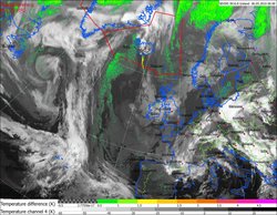
EUMETSAT and NOAA satellite images - 07 May 2010 15:15
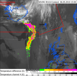
During the evening of 5th May there was an abrupt increase in ash discharge from Eyjafjallajökull.
Aerosol particles are detectable through their light scattering properties. Their signature is a particular brightness temperature (channel) difference recorded by meteorological satellites and other earth observation satellites. This type of detection is one of the main observational evidence for the existense of ash particles in the atmosphere.
The method, when utilizing 11 micrometer and 12 micometer wavelength channels, works well for ash clouds with mean aerosol sizes of less than 6 microns. The detection is however largely limited by cloudy conditions, which can hinder the progression of the warm thermal background radiation through the aerosol and up to the thermal imaging camera of the satellite. For strong detection it is important that the background be warm in comparison to the aerosol. A thermal background such as from the ocean surface, land or low clouds, works best because warm objects radiate more and result in greater amounts of scattered radiation, light-particle 'collisions' if you will.
As a cooperating member of EUMETSAT, the Icelandic Meteorological Office can monitor these ash signatures in real time. The animation shows the development of the volcanic ash cloud from the evening of Wednesday 5th May until the afternoon of Thursday 6th May. The ash is clearly detectable by Brightness Temperature Difference (BTD) between two thermal channels in meteorological satellites. The images were generated chiefely with channels from EUMETSATS´s geostationary satellite, MSG. However, image segments from NOAA's polar orbiting satellites are superimposed ontop where they were available.
The images show that most of the thermal background radiation comes from low clouds at ca. -20°C, while the aerosol temperature up at high altitudes would have been much lower, near -60°C.
An earlier article can be viewed relating to the spread of the initial ash cloud on 15th April.
Aerosol from soil and sand is detectable with the same techniques. An article was written on our Icelandic web-site relating to the detection of sand aerosol from Landeyjasandur, earlier this year.
Assessment - 06 May 2010 20:15
Explosive activity has increased and effusive part has decreased for the last two days. This results in a higher eruption column with increased tephra fallout.
The ash plume, observed from commercial pilots between 0530h and 0800h: 30,000 ft/9km. ICG helicopter flight between 13h and 14h: sometimes under 20,000 ft (where there is a cloud bank) and oscillates up into the cloud bank (over 9 km).
Considerable ashfall at Þykkvabæjarklaustur in Álftaver (at a distance of 65-70 km), (everything has turned black). It has not been established whether the ash cloud south of Eyjafjallajökull is ashfall or ash that has already fallen and is being blown from the ground.
Discharge from Gígjökull decreases further and meltwater seems to be running from the eastern side of the glacier. This is different from Tuesday's meltwater were water was running from the west side. Lava flow might be changing the direction of meltwater flow. Such changes should be taken seriously with regard to possible outbursts due to accumulation of meltwater.
Earthquake activity is still being recorded. At least 10 earthquakes have been located since midnight. Most of the earthquakes are sourced beneath or south of the top crater in the eruptive conduit that has formed since 3 May. Most of the earthquakes are less than magnitude 2, the biggest M2.2.
There are no signs that the eruption is about to end. No measurable geophysical changes within the Katla volcano.
See more in Status Report issued by Icelandic Meteorological Office and Institute of Earth Sciences, University of Iceland, at 18:00.
Assessment - 05 May 2010 20:50
Increased seismicity suggests that new material is intruding from deep below Eyjafjallajökull and latest GPS-observations suggest inflation. So far, GPS-signals are not large.
Plume at 5.5-6.5 km height (a.s.l.) according to IMO's weather radar.
Due to mild weather and snowmelt, increase in discharge was noticed in Markarfljót peaking at midnight. Discharge from Gígjökull seems to be decreasing and oscillations in water temperature at the old Markarfljóts bridge relate to air temperature. Pulses of meltwater from Gígjökull are unnoticeable.
Lava flows to the north and spreads at 500 m a.s.l. The lava tongue is about 200 m wide and lava channels that join at the tongue are about 30-60 m wide. The lava channels gets wider every day.
There are no signs that the eruption is about to end.
See more in Status Report issued by Icelandic Meteorological Office and Institute of Earth Sciences, University of Iceland, at 18:00.
Magma intrusion - 05 May 2010 13:40
Since Monday 3 May, increased earthquake activity beneath Eyjafjallajökull has been recorded. Precise locations of the earthquakes show that their source is at first very deep, at about 23 km depth, but then migrates upwards. This strongly indicates that “new” magma is intruding into the magma conduit and pushing on the over-lying magma, causing a difference in pressure at the surface. It is therefore anticipated that the eruption will continue at full force in the next days.
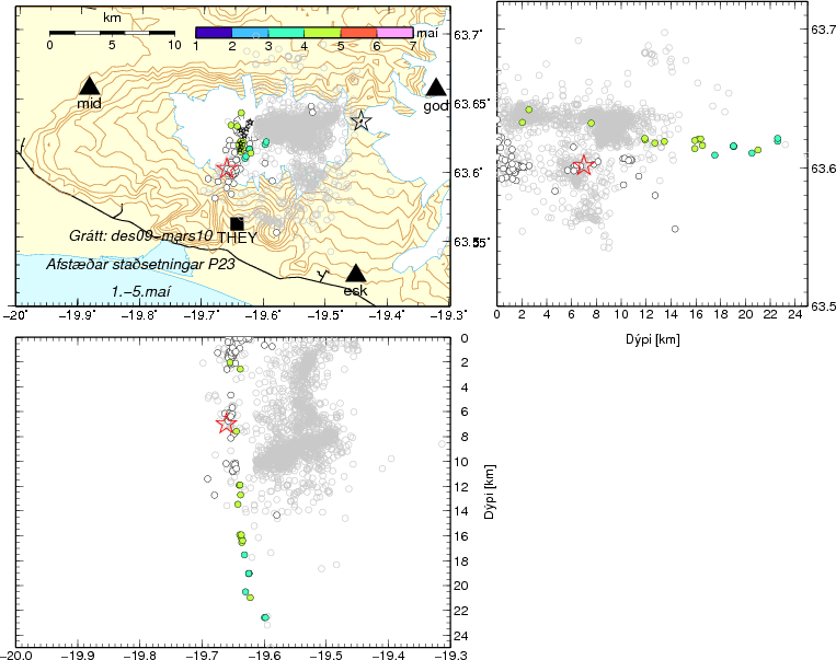
Significant changes in horizontal movement at GPS stations around Eyjafjallajökull have been observed in the last 48 hours. Renewed northward displacement is seen at stations BAS2 and STE2, located just north of the ice cap. To the south, westward movement is apparent at THEY (see figure below), while station FIM2 - located further east - shows eastward movement.
The distribution of earthquake activity in the magma conduit could also indicate the location of the magma chamber that has fuelled the eruption since 14 April. It is considered to be at a depth of approx. 3-5 kilometers, in an area where no earthquakes are detected.

Figure text: Earthquake activity beneath Eyjafjallajökull in April and May 2010. The green and bluegreen circles represent earthquakes occurring on 3-4 May, first at a great depth and gradually moving upwards on 4 May. The white circles represent earthquakes that were recorded from 13 to 30 April. Gray, open circles show earthquake locations from 2009 to March 2010. The red star represents the source of an M2.7 earthquake that was recorded at the beginning of an intense earthquake swarm that preceded the onset of the eruption by a couple of hours. The black stars show the location of the eruptive fissures at the summit and flank (Fimmvörðuháls) of Eyjafjallajökull.
GPS stations BAS2, FIM2, and STE2 are operated in collaboration with the Earth Sciences Institute, University of Iceland. For further details, see site at IMO and site at Earth Sciences Institute.
Assessment - 04 May 2010 19:00
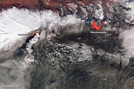
The usually white Eyjafjallajökull is black. Above it rises the plume from the crater and light steam plumes from Gigjökull. Markarfljót river beneath. Photo: Ólafur Sigurjónsson.
More photos from Ólafur. And photos from flights with the Icelandic Coast Guard (ICC). The photos also show the small eruption on Fimmvörðuháls 20 March to 12 April.
Plume was observed at 5.8-6 km height (19-20,000 ft) estimated from the Icelandic Coast Guard (ICG) flight at 10:40 and 15:30 GMT. It is heading east-south-east to south-east from the eruption site. Plume track clearly visible up to 300-400 km distance from the eruption site on a NOAA satellite image at 13:13 GMT.
Water levels have been rather constant. Water temperature at Markarfljot bridge was low this morning (below 2°C) but seems to be rising (about 5°C at noon). Water level seems to be slightly decreasing.
Lava is still flowing northwards, forming a lava fall down the steep hill under Gígjökull, about 4 km north of the crater. Blue gas is seen rising from the lava and white steam plumes are seen somewhat lower and mark the front of the lava stream. The size of the eruptive crater is 280 x 190 m. Lava splashes are thrown at least a few hundred meters into the air.
Overall assessment is that it is more explosive activity and ash production than was observed yesterday. Progression of the lava seems to be slower than yesterday.
Presently there are no indications that the eruption is about to end. No measurable geophysical changes within the Katla volcano.
See more in Status Report issued by Icelandic Meteorological Office and Institute of Earth Sciences, University of Iceland, at 15:00.
Assessment - 03 May 2010 19:20
Largest eruption plumes were observed at 5-5,5 km height (17-18,000 ft) estimated from the Icelandic Coast Guard (ICG) flight at 14:30. The plume rises higher after large explosions. It is heading east-south-east to south-east from the eruption site.
Scientists working at Gígjökull regularly hear explosions and booming sounds and feel the ground vibrate. The vibrations are not felt in 3-4 km distance.
Today water temperature at the Markarfljot bridge was measured 11°C but about 3°C in a 2 km distance from Gígjökull. Water is flowing on both sides of the glacier and pulses of meltwater flow down the channels every 10 minutes or so. Water level gauge at Gígjökull also records the pulses. Temperature measurements at Markarfljot bridge show a pulse of water temperature up to 17°C at 06:00 GMT this morning. Water temperature has now dropped down below 4°C.
No measurable geophysical changes within the Katla volcano.
The overall activity has not changed much since yeasterday (from the last report). Presently there are no indications that the eruption is about to end.
See more in Status Report issued by Icelandic Meteorological Office and Institute of Earth Sciences, University of Iceland, at 16:00.
Assessment - 03 May 2010 08:35
The eruption is mixed, with the lava-producing phase being larger than the explosive phase. During the last 2-3 days, the plume has been darker and wider than in the preceding week. Tephra fall-out in the vicinity of Eyjafjallajökull has increased. Dark grey ash clouds are observed over the eruptive site. White steam plumes are rising from Gígjökull, north of the eruption site. The elevation is 4-5.4 km (13-18,000 ft). Clouds of ash at lower elevations were observed drifting south-east of the eruption site. Moderate ash-fall was reported in the village of Vík at noon, Sunday, located 40 km south-east of Eyjafjallajökull.
From the location of the steam plume over Gígjökull, lava has advanced over 3 km north of the eruption. Steam plumes over the glacier edge from 19:40 GMT suggest that lava may have advanced even further. A rough order-of-magnitude estimate of lava volume can be obtained from the dimensions of the ice canyon. This estimate gives a lava production rate of-the-order 20 m3 s-1 (i.e. 50 tonnes s-1). The explosive phase may be 10-20 tonnes s-1.
The explosive phase has increased somewhat in intensity during the last few days. Presently, there are no measurable indications that the eruption is about to end.
No measurable geophysical changes within the Katla volcano.
See more in Status Report issued by Icelandic Meteorological Office and Institute of Earth Sciences, University of Iceland, at 21:00 yesterday evening.
Assessment - 02 May 2010 09:00
Plume elevations and magma discharge levels remain similar to the preceding eight days of activity. Lava continues to flow north from the eruption site and down the Gígjökull glacier. Today's explosive activity and ash production represents a fraction of conditions during the height of the eruption (14-17 April). Presently, there are no measurable indications that the eruption is about to end.
See also Status Report issued by Icelandic Meteorological Office and Institute of Earth Sciences, University of Iceland.
Assessment - 30 April 2010 19:00
Plume elevations and magma discharge levels remain similar to the preceding seven days of activity. Lava continues to flow north from the eruption site and down the Gígjökull glacier. Today's explosive activity and ash production represents a fraction of conditions during the height of the eruption (14-17 April). Presently, there are no measurable indications that the eruption is about to end. See also Status Report issued by Icelandic Meteorological Office and Institute of Earth Sciences, University of Iceland. There are no measurable geophysical changes within the Katla volcano.
Assessment - 29 April 2010 23:50
Airborne radar surveys show a well-formed crater. Lava is spreading northward from the crater toward the head of Gígjökull. Ice continues to be melted by the propagating lava front. Web-camera views show continued discharge of water from Gígjökull due to lava-ice interactions.
Plume elevations, seismic tremor intensity and magma discharge levels remain similar to the preceding six days of activity. Booming sounds were reported from Selsund, located ~40 km north-northwest of the eruption site. Explosive activity and ash production represents a fraction of conditions during the height of the eruption.
No measurable geophysical changes are within the Katla volcano.
The above is based on status report issued collectively by IMO and the Institute of Earth Sciences.
Assessment - 28 April 2010 22:40
Plume elevations and magma discharge levels remain similar to the preceding five days of activity. Lava continues to flow north in the Gígjökull glacier from the eruption site. From steam emissions over Gígjökull, it is likely that lava is exploiting the drainage pathway created in the glacier by earlier floods. There are no measurable indications that the summit eruption of Eyjafjallajökull is about to end.
Discharge of meltwater from Gígjökull increased signifcantly today, reaching levels not exceeded since 16 April 2010. Meltwater draining beneath the old Markarfljót bridge, ~18 km downstream from Gígjökull, had a temperature of over 11°C.
The above is based on status report issued collectively by IMO and the Institute of Earth Sciences.
The ash cloud will be analysed - 28 April 2010 17:45
Tomorrow and Friday, scientists from the German Aerospace Center (DLR) will do a measurement flight of the volcanic ash cloud over Eyjafjallajökull, using the specially equipped aircraft Falcon 20E. The Volcanic Ash Advisory Centre in London uses DLR data, as well as information from IMO, in order to forecast the distribution of the volcanic ash.
It has already been established that the ash is more coarse grained now, than during the initial stages of the eruption. Tomorrow's measurements will refine model results.
Assessment - 27 April 2010 22:40
Overall assessment: Plume elevations and magma discharge levels remain similar to the preceding four days of activity. Lava continues to flow north from the eruption site toward the head of the Gígjökull glacier. Despite light ash-fall occurring up to 45 km west of the eruption site, today's explosive activity and ash production represents a fraction of conditions during the height of the eruption (14-17 April). There are no measurable indications that the eruption is about to end.
Seismic tremor: Intensity comparable to the preceding four days of eruptive activity.
Earthquakes: No locatable seismicity has been recorded today beneath Eyjafjallajökull.
GPS deformation: Horizontal displacement towards the centre of the volcano, in addition to vertical subsidence. These observations are consistent with deflation of a magma reservoir beneath Eyjafjallajökull.
Magma flow: No measurements possible today; however, the intensity of the eruption suggests that the discharge level is similar to the preceding four days (i.e. 20-40 tonnes s-1).
Meltwater: Continuing discharge of water from Gígjökull due to ice-melt at the eruption site. Discharge at the old Markarfljót bridge, 18 km from Gígjökull, is estimated at ~100 m3 s-1, of which ~30 m3 s-1 is baseflow.
Other remarks: No measurable geophysical changes within the Katla volcano.
Based on: IMO seismic monitoring; IES-IMO GPS monitoring; IMO river gauges; information from local police; and aerial observations over the eruption site.
The above is based on status report issued collectively by IMO and the Institute of Earth Sciences at 19:00 this evening.
Assessment - 26 April 2010 19:15
No visual observations at eruption site; no magma flow is visible. Radar images show continuous build-up of a tephra crater/cone in the northern ice cauldron; the diameter of the crater is 200 m and the height of the crater cone is 130-170 m. GPS observations are consistent with deflation of a magma reservoir beneath Eyjafjallajökull.
No measurable geophysical changes within the Katla volcano. Earthquake activity on the north-western edge of Vatnajökull is unconnected with the ongoing eruption.
Magma flow-rate and plume height has remained at similar levels during the last few days. Lava continues to flow northward. No signs of melting or meltwater discharge towards the south. There is no indication that the eruption is about to end; however, it is an order of magnitude smaller than in the first explosive phase.
The above is based on a status report issued collectively by IMO and the Institute of Earth Sciences at 18:00 this evening.
Measurements made in Europe last week, confirm the results of the dispersion models for ashfall. The Volcanic Ash Advisory Centre in London, VAAC, issues new graphics intended for flight traffic every few hours (see red link at top of page).
Conditions and assessment - 25 April 2010 22:30
The following is based on a status report issued collectively by IMO and the Institute of Earth Sciences at 18:00 this evening.
Conditions at eruption site: Overall activity similar as yesterday. Eruption seen from west in the morning - north crater still active. External water has not affected vent activity much since 18 April. Geologists' field observations (2-10 km from vents) show that explosivity is magmatic and that the tephra produced since 18 April is much coarser than during first four days. Explosions heard at Fljótshlíð, 10-15 km NW of vents. Meltwater discharge suggest similar lava activity. Processing of data obtained yesterday shows that lava had advanced 400-500 m northwards from crater, forming an ice depression extending some 700 m from vents.
Overall assessment: Magma flow rate has remained at similar level over the last few days while plume activity is slowly declining. Lava continues flowing towards north. No signs of melting or meltwater discharge towards south. No signs of termination of eruption.
Lates indications - 25 April 2010 11:30
Yesterday evening, scientists from IMO and from the Institute of the Earth Sciences found indications of lava flow from the eruption site. Following is an extract from their description:
"North of crater a roughly 300 m long and wide depression has been melted out in the last three days. Steam plumes rise from the depression, especially at the margins. This is explained by lava flowing northwards from the crater with the steam rising where lava meets ice ... Flow of lava is considered to have begun around noon on Wednesday 21 April ... No signs of melting or meltwater discharge towards south."
Little changes - 24 April 2010 11:15
Volcanic tremor has been similar as the last 2-3 days.
Ash fall may be expected to the west and northwest from the eruption, minor in the Reykjavík area.
Water level in Markarfljót river is slightly higher than yesterday.
Similar status - 23 April 2010 10:45
Volcanic tremor has been similar the last 24 hours. GPS stations around Eyjafjallajökull showed deflation associated with the eruption. No movements are associated with the Katla volcano.
The plume could be seen on IMO's radar till 04:00. This morning it rose up to 16.000 feet, ca 4.8 km, and ash is blowing towards west.
Water in Markarfljót river increased slightly yesterday, probably due to continuous flow from the eruption area (Gigjökull).
Interesting satellite images since 9th and 20th April from the Canadian Space Agency, CSA: Eruption of the Eyjafjallajökull volcano in Iceland, as seen by RADARSAT-2. Brief discussion.
WMO issued a briefing (20 April) of frequently asked questions regarding the eruption and the ash plume (pdf 1,5 Mb).
Eruption similar - 22 April 2010 11:15
Volcanic tremor increased in the afternoon yesterday but after midnight it decreased again and has been relatively stable since then.
The plume rose up to 3-4 km height yesterday afternoon and seems similar this morning according to IMO's radar.
Little changes - 21 April 2010 10:00
Little changes since yesterday. The plume rises up to ca 2 km height above the volcano but up to ca 5 km south of Iceland.
The volcanic tremor has slightly decreased since yesterday.
Deflation - 20 April 2010 13:30
Latest available results from GPS stations around Eyjafjallajökull showed deflation associated with the eruption. This suggested that the volume of eruptive material which has been ejected already, relieves pressure off the volcano.
No movements associated with the Katla volcano are presently observed.
Sound blasts - 20 April 2010 12:30
Heavy sound blasts have been heard and found near Eyjafjallajökull, especially south and east of the mountain, and more clearly after wind speeds became lower.
The viscosity of the magma from Eyjafjallajökull is higher than on Fimmvörðuháls. This enhances the explosive sound effect. Shock- and soundwaves are carried long distances.
Information received earlier (14-19 April)
Meteorological
Monday 19th the eruption was still ongoing with the height of the plume 2-3,000 ft above the volcano (upto 1 km), but the plume ascended to 20,000 ft above sealevel (6-7 km) when it drifted southward. Later in the afternoon reports indicated maximum plume height around 15,000 ft (5 km) with ash clearly visible in the clouds. Decreasing windspeed Monday evening will slow the advection of the plume. Southerly winds and rain on Tuesday evening.
On 17 April at least 115 lightning strikes were recorded in the vicinity of the eruption. On 18 April only 17 strikes were detected. Taking this activity as a measure of ash load in the plume, fewer fine-grained particles are being jetted into the atmosphere. At present, no lightning has occurred on 19 April; see an automatic list of lightnings.
If phreatomagmatic activity intensifies again and ash is ejected to elevations over 6 km (~20,000 ft) a.s.l., then a low-pressure system presently SE of Iceland (19 April) will cause southward-tracking ash clouds to be deflected eastwards toward northern parts of the UK; see Volcanic Ash Advisory Centre, London. Details on the composition and grain-size (pdf 0.02 Mb) of the erupted tephra are available from the Institute of Earth Sciences, University of Iceland.
Seismic
Volcanic tremor at a dominant frequency of 0.5 Hz remains continuous. Since ~11:00 GMT on 18 April, tremor levels have intensified beyond levels maintained since 16 April, as shown in a real-time plot. We presently don't know the source mechanism behind the heightened low-frequency tremor, although presumably phreatomagmatic conditions still prevail at the eruption site.
Locatable seismicity since the beginning of the Eyjafjallajökull eruption can be seen on the linked map. The epicentres delineate an elongated zone of fracture orientated NNE-SSW. Few earthquakes have occurred beneath Eyjafjallajökull since the pre-eruptive swarm ended in the early hours of 14 April, as shown on the linked graph.
Geodetic
Daily solutions from continuous, 15-s GPS stations around Eyjafjallajökull, operated in conjunction with the University of Iceland, show centimetre-scale horizontal movements toward the centre of the volcano, with some stations registering centimetre-scale vertical decreases too. An overview of GPS time-series from nine stations around Eyjafjallajökull is available.
Glaciological
During overflights on April 19th it was apparent that the ice cauldrons over the eruption site have coalesced to form a larger cauldron. See also a report from the Institute of Earth Sciences on Radar observations 15-19 April 2010 (Eyjólfur Magnússon).
Following an initial period of glacial flooding on 14-15 April, relatively little water is draining from the northern flank of the ice cap now (19 April). Significant ponding of meltwater at the eruption site doesn't seem to be occurring, as there seems to be a largely open pathway for drainage over and through the Gígjökull glacier.


