
The crust has changed
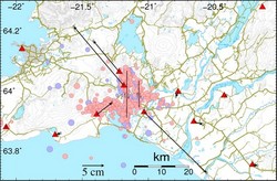
The strong earthquake on 29 May displaced the Earth's crust in Southern Iceland, as shown on this map. Red triangles represent GPS stations and black arrows indicate horizontal movement.
The GPS stations are part of a large network used for monitoring crustal movement. The network is run by IMO in co-operation with other institutes, in Iceland and overseas.
At Selfoss, lateral displacement was 20 cm to the southeast and at Hveragerði 17 cm to the northwest. Landrise was 5 cm and 3.5 cm, respectively.
These tectonic changes are permanent and in concordance with a dextral fault through the mountain Ingólfsfjall, and another which lies from the coastal town of Eyrarbakki and due north beyond the town of Hveragerði.
Scientists from related Icelandic institutes co-operate with IMO in mapping the extent of this deformation, using fixed reference points.
Daily results from the GPS network are available on our web-site.


