
News
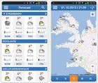
The weather app
Weather forecasts and the current weather condition can be checked through a weather app provided by IMO. Location is detected if GPS on; alerts issued by the Met Office appear automatically during the day and a personal weather watch can be arranged to send notifications when certain criteria are met. An interactive weather map shows weather observations at any station in the country.
Read more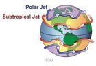
The northern hemisphere polar jet stream and links with arctic climate change
An international workshop in the field of dynamic climatology was held at the Icelandic Meteorological Office, Reykjavík, 13 -15 November 2013. The aim of the workshop was to assess the state of knowledge of northern hemisphere polar jet stream changes and mechanisms, focusing on mid-high latitude linkages and occurrence of extreme weather events.
Read more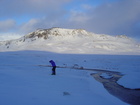
Arctic data rescue, citizen-science, and collaborative research
Progress in Arctic science is hampered by sparse data or data that are inherently difficult to interpret. An international IASC workshop was hosted by IMO,11-12 November 2013, where a variety of data/information sources were explored and new pathways to effective utilization across disciplines discussed.
Read moreAdapting to Change: From Research to Decision-making
Adaptation to climate changes is already high on the agenda in the Nordic and international societies. The conference Adapting to Change: From Research to Decision-making, to be held in Copenhagen 25-27 August 2014, seeks to advance existing common ground between scientists, practitioners and decision-makers and establish new ways forward for informed adaptation; following earlier successful conferences in Stockholm and Helsinki.
Read more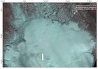
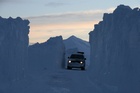
Hofsjökull ice-cap
An excursion has confirmed that a new cauldron has formed in one of Iceland's ice caps, Hofsjökull, as a result of a jökulhlaup from a subglacial, geothermal area. Travellers are advised to be very careful during journeys on Hofsjökull. Crevasses surround the new cauldron.
Read moreEEA Grants Conference on Adaptation to Climate Change
The Governments of Iceland, Liechtenstein, Norway and Portugal are hosting a conference in Lisboa on the role of water in adaptation to climate change. The theme of this EEA Grants Conference is: Too Much, Too Little - The Role of Water in Adaptation to Climate Change. Among the issues addressed are policy framework, news in science, water related national challenges, adaption policies and the need to think beyond national borders.
Earthquake activity continues
Earthquake M3.8 occurred 2nd October at 19:40. Its hypocenter coincides with swarm activity which has been recorded since 25 September. The earthquake, which is the largest recorded in the swarm, was felt in Dalvík, Ólafsfjörður and Siglufjörður. Hundreds of events with magnitudes 1-3 belong to the swarm activity.
Read more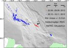
Earthquakes offshore north Iceland
Two earthquakes reaching magnitude 3 and 3.2 occurred this morning at 06:14 and 07:41 offshore North Iceland, 10 km NW of Gjögurtá. They are a part of swarm activity which has been ongoing since September 25. Roughly 1000 earthquakes have been recorded in the swarm.
Read more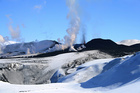
First Annual Meeting of FUTUREVOLC
The first Annual Meeting of FUTUREVOLC was held 23-25 September in Iceland with around 60 participants from 12 countries. Some of the main objectives were to establish an integrated volcanological monitoring system, develop new methods to evaluate volcanic crises and improve delivery of relevant information to civil protection and authorities.
Read more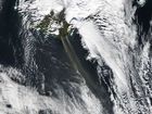
Dust plume off the south coast
Strong northerly winds for the past few days have given rise to a large dust plume off the south coast of Iceland, as seen on a MODIS satellite image from NASA, 16 September 2013. This is quite frequent but has been particularly marked now, with a dust plume reaching easily a few hundred kilometers out into the Atlantic.
Read more
Consultation meeting
The Director General of the Icelandic Meteorological Office invited his colleagues of the other Nordic Meteorological Institutes to the northern town of Ísafjörður 26 – 28 August 2013, where IMO‘s Snow Avalanche Centre hosted their Annual Consultation Meeting.
Read more
Full membership to EUMETSAT
Iceland agreed to its full accession to EUMETSAT, the European Organisation for the Exploitation of Meteorological Satellites, 30 August 2013. Examples of such products can already be found at the IMO web, such as thermal imagery and scatterometric ocean surface wind data. Icelandic companies and industry will now be able to bid for EUMETSAT tender invitations.
Read more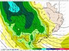
Bad forecast for Friday and Saturday in Northern Iceland
Special attention is given to bad weather forecast for Friday 30 and Saturday 31 August. High wind is expected with rain on lowland but with sleet and snow on higher ground, especially in the North. It is not possible yet to predict the actual path of the low-pressure and hence it is not possible to say which area of the country will be most affected.
Read more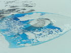
Impending outburst flood in Skaftá: Likely hazards
An outburst flood is expected in the Skaftá river, which drains from western Vatnajökull. The timing of the flood is unknown but it could occur within days to several weeks. Here is an outline of the hazards that are likely to occur during the course of the flood.
Read more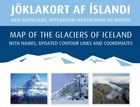
Map of the Glaciers of Iceland
A Map of the Glaciers of Iceland has been published by IMO. It shows the extent of the glaciers at their maximum about 1890 and at the end of the 20th century. An explanatory, illustrated pamphlet accompanies the map. The text of the pamphlet and the map explanation are in Icelandic and English. The Map of the Glaciers of Iceland is of use to the general public as well as scientists and can be ordered directly from Iðnú.
Read more
Safetravel
The webpage Safetravel is run by ICE-SAR and is part of a bigger project in which a number of companies, public institutions and individuals combine their effort in order to reduce the risk of accidents in travelling and tourism in Iceland. The Icelandic Meteorological Office has supported the Safetravel project since its beginning in 2010.
Read more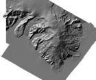
Lidar measurements of the cryosphere
Airborne lidar measurements are in widespread use for mapping changes of ice sheets and glaciers. A workshop in Reykholt, Iceland, 20-21 June 2013, is aimed to bring together specialists from lidar campaigns, glacier mapping teams and scientists and engineers developing novel laser technologies for airborne and space use.
Read more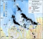
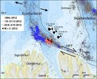
Workshop on Earthquakes in North Iceland
The strongest earthquake swarm in over 30 years hit North Iceland in October 2012. In light of these events, a workshop is held at Húsavík 6-8 June 2013, focussing on earthquakes in North Iceland. The presentations relate to the geological history and current tectonics as well as likely scenarios in case of a major event in North Iceland and possible precautionary measures to reduce the impact of a future large earthquake.
Read more
A new absolute minimum temperature record
On 2nd May 2013 the automatic weather station at Brúarjökull registered a minimum temperature of -21.7°C. This is the lowest temperature ever measured in Iceland in May.
Read more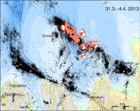
Earthquake activity east of Grímsey has decreased
An M5.5 earthquake occurred east of Grímsey 2nd April 2013 followed by several hundred aftershocks. This marked the onset of an intensive swarm. The activity continued with gradually decreasing intensity the following day on both clusters. Around midnigh two earthquakes of magnitude 3.4 and 3.6 occurred in the northwestern part of the cluster and were felt in Grímsey. This led to a temporary increase in activity, which since then has been decreasing.
Read more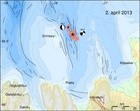
Earthquake sequence east of Grímsey
A M5.5 earthquake occurred at 00:59 on 2nd April 2013 about 15 km east of Grímsey island offshore North Iceland. The earthquake was felt at Grímsey, Húsavík, Raufarhöfn, Mývatnssveit, Akureyri and Sauðarkrókur. Another M4.7 earthquake followed at 08:56 and was located about 7.5 km northwest of the night's main event.
Read more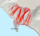
Avalanche web map viewer
The Icelandic Met Office has developed an experimental avalanche web map viewer aimed at easing access of the public and specialists to the avalanche data gathered and processed within the institute. The current edition of this viewer features information on snow depth, risk zones, evacuation zones, and past avalanches.
Read more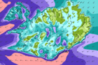
Wind and snow
6.3.2013 As everyone in Iceland is aware of, very bad weather is prevalent in all of the country. Reykjavík is unusually hard hit by winds and snow. Users of the web are advised to observe frequently updated maps and text forecasts, found at the upper part of the front page. Blowing snow is expected in the south and west parts until evening.
Read more
Flood subsiding
Discharge levels in the upper reach of the Hvítá catchment are decreasing rapidly. At 14:00 UTC 27 February, floodwater discharge at Fremstaver was about 264 cubic metres per second, which is 50% lower than yesterday's observations. Water-level measurements at all other monitoring locations in the catchment show that discharge levels are decreasing progressively. Although no further intense rainfall is forecast for the region during the coming days, flood conditions are expected to last for the next one to two days.
Read more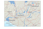
Flood warning for Hvítá and Ölfusá
At 13:00, Tuesday 26 February, the discharge of Hvítá at Fremstaver, in the northern part of the catchment, was 520 cubic metres per second. It takes floodwater in this region several hours to drain south, so maximum discharge will not be reached in the lower part of Hvítá (Ölfusá) until later Tuesday evening or early Wednesday. Additional rainfall is forecast for the region Tuesday evening, followed by colder, drier conditions. River levels should decrease significantly in the coming days.
Read more
Flood warning for Hvítá and Ölfusá rivers
River Hvítá and it's tributaries are growing fast and further rain is forecast. Flood is expected in Hvítá and Ölfusá in the early hours of tomorrow: First in Auðholtshverfi, west of Flúðir; then in Skeiðar and then at Dagmálahólmi, north of Selfoss. Flooding might occur at Kaldaðarnes, south of Selfoss. Farmers are advised to check on livestock near flood-prone rivers. Flooding is also expected in Hverfisfljót and Djúpá. Travellers are advised to stay away from these rivers.
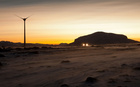
Wind turbines
The Icelandic power company Landsvirkjun has started the operation of two wind turbines in an area known as Hafið, within the construction area of Búrfell Power Station in the south of Iceland. The IMO, Landsvirkjun, Landsnet and the University of Iceland are participants in a Nordic project called Icewind. The project objectives include resource mapping near Iceland and improved land-wind resource map such that full-scale studies can be carried out on the integration of hydro- and wind power in Iceland.
Read more
Web update - avalanches
The web is undergoing update due to necessary improvements. Apologies for any inconvenience this may bring. Avalanche conditions are now given on a selected front page. Additionally, a forecast of avalanche danger for selected highland areas is given twice a week.
Many avalanches – no injuries
Many avalanches fell in the Westfjords and in North Iceland during the last days of December 2012. This is the worst spell of snow avalanches since 2005. Warnings were issued and evacuation plans were carried out in the Westfjords.
Read moreSearch
Contact IMO
© Veðurstofa Íslands | Bústaðavegi 7- 9 | 105 Reykjavík | Phone 522 6000 | Fax: 522 6001
Recording 902 0600 | SSN 630908-0350
Contact us | Employees | Terms and conditions | Sitemap


