
News
EUROVOLC is bringing the European volcanological community closer together
The European Network of Observatories and Research Infrastructures for Volcanology EUROVOLC is a H2020 Research and Innovation Project of the European Commission. It will construct an integrated and harmonized European volcanological community able to fully support, exploit and build-upon existing and emerging national and pan-European research infrastructures, including e-Infrastructures of the European Supersite volcanoes. The harmonization includes linking scientists and stakeholders and connecting still isolated volcanological infrastructures located at in situ volcano observatories (VO) and volcanological research institutions (VRIs).
Read more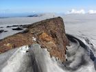
100 years since Katla erupted
Today, 12 October, is the 100-year anniversary of the 1918 eruption of Katla. The volcano is considered one of the most hazardous of Iceland's 32 active volcanic systems. During the last 1100 years, Katla has erupted at least 21 times, with an average repose interval of around 50 years. The current one-hundred-year repose marks the longest period since a Katla eruption. The Katla volcanic system is located in the eastern volcanic zone. It is characterized by an 80-km-long fissure swarm and an ice-clad central volcano. The central volcano is covered by the Mýrdalsjökull ice-cap and it includes a 9 by 14 km caldera, with ice-thickness up to 700 m.
Read more
Cooperation is a must for adaptation to and mitigation of climate change
The consequences of this summer's weather have included droughts, heatwaves and wildfires, straining the society's capacity to cope with such perils. Most of the Nordic and Baltic countries have experienced the hottest summer on record, while the number of days with rain in parts of Iceland was exceptionally high. Was this summer just an exceptional freak event or is this due to climate change? And if this is due to climate change – what can be done?
Read more
Hazardous weather expected later this week
The first hazardous weather of this autumn is expected later this week which is unusually early this year. Strong northern winds are forecast from Wednesday until early Saturday morning. Precipitation associated with this weather will mostly fall on the northern part of the country in the form of rain, sleet or snow. At any point during this bad weather sleet or snowfall can be expected down to sea level.
Read more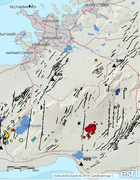
Earthquakes shake Bláfjöll ski-area
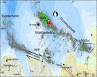
On the 13th of September at 20:17, two earthquakes of magnitude around M4 occurred, only 5 seconds apart, 6 km south of Bláfjöll mountains. Several smaller aftershocks were recorded. The earthquakes were felt widely in the capital area, and also in Ölfus and Akranes. The earthquakes are located on the tectonic plate boundary that lies eastwards along the Reykjanes peninsula where earthquakes of magnitude around M6 can occur.
Read more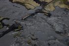
The August glacial outburst - one of the larger jökulhlaups to have affected Skaftá in recent decades
The jökulhlaup peaked at Sveinstindur at around 00:00 UTC on 5 August, having reached a discharge of approximately 2,000 cubic metres per second. In terms of discharge, the August jökulhlaup is one of the larger floods to have affected Skaftá in recent decades. However, with a maximum discharge of 3,000 cubic metres per second, the October 2015 jökulhlaup remains the largest and most damaging flood to have affected Skaftá since the mid-1950s.
Read more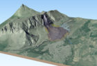
Displacements in Fagraskógarfjall for some time before the landslide fell
Sentinel-1 satellite radar images show displacement in the starting area before July 7th, when the landslide occurred according to InSAR analysis by Vincent Drouin at the University of Iceland and the National Land Survey of Iceland. The mountainside in the starting area of the landslide is different from the surrounding slopes according to an interferometric analysis of the radar images. The displacement in the last days before the landslide was at least a few centimetres. The starting area also appears to have been moving in 2017, 2016, and 2015 but at a slower rate.
Read more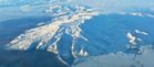
Status of Öræfajökull volcano
After a series of meetings with scientists from The Icelandic Meteorological Office, The University of Iceland and Iceland Geosurvey, The Department of Civil Protection has issued the following statement.
Read more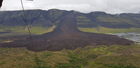
A large landslide falls in Hítardalur valley
A large landslide fell in Fagraskógarfjall mountain in Hítardalur valley, W-Iceland, in the morning of July 7th. The landslide crossed the river Hítará, damming the river and causing a lake to form above the debris tongue. The water found a new channel the next day into Tálmi, a riverbed that reconnects with Hítará a few km farther downstream.
The landslide fell from an area that showed evidence of earlier ground displacements and might be an old landslide deposit. The displaced material is a mixture of e.g. rock debris, scree from the lower part of the hillside, swamp soil and sediments from ancient lakes on the valley bottom. A preliminary estimate of the volume of the slide is 10–20 million m3. The area of the debris tongue is ca. 1,5 km2 and the debris is up to 20–30 m thick.
Read more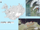
Fractures in Svínafellsheiði and a potential rockslide on Svínafellsjökull
Civil Protection advises against travel on Svínafellsjökull due to landslide danger. In particular, guided tours on the glacier are discouraged. Travellers are advised to stop only for a short while at viewpoints by the glacier tongue.
Read more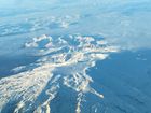
IMO and The Icelandic Civile Protection Agency reassess the status for Öræfajökull
It is close to nine months since an unrest in Öræfajökull was detected. The unrest was apparent from elevated seismicity, the development of a depression in the ice-surface (cauldron) within the caldera, and the presence of geothermal gases from a glacial river. At this time, the geothermal activity beneath Öræfajökull was assessed to be high relative to previous decades.
Read more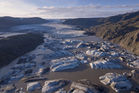
Glaciers in Iceland continue to retreat
The mass balance of the Icelandic glaciers has been negative since 1995 with the exception of the year 2015 when it became positive for the first time in 20 years. The mass balance in 2016 was again negative by a similar magnitude as in recent years. The mass balance of Langjökull and Hofsjökull
was again negative in 2017 whereas Vatnajökull was almost in balance. The glaciers have lost approximately 250 km3 of ice since 1995, which corresponds to ca. 7% of their total volume. Glaciers in Iceland have retreated rapidly for more than two decades and glacier downwasting is one
of the most obvious consequences of a warming climate in the country.
Read more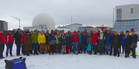
EUROVOLC – a networking project kick-off meeting
A group of more than 70 Earth and atmospheric scientists from 9 European countries met earlier this month in Keflavik to start their collaboration on the Horizon2020 Infrastructure project EUROVOLC. The group represents 18 partners comprising volcano research and monitoring institutions, civil protection and companies from the IT and geothermal industry.
Read more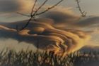
The weather in Iceland in 2017
The year 2017 was warm in Iceland and the weather was mainly favourable. February, May, September and October were particularly warm. The East had unusually much precipitation. Heavy rainfall in the East and Southeast at the end of September resulted in extensive flooding from major rivers in the area. The last two months of the year were considerably cooler than the previous months. November was cold and the last days of December were the coldest days of the year. Wind speed was slighly lower than average.
Read more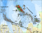
Seismic swarm east of Grímsey on the decline
The seismic swarm east of Grímsey has been on the decline for the last days. Substantial seismic activity is however still ongoing with small swarms occurring, including up to magnitude M3 earthquakes. This night, February 23, two magnitude M2.8 earthquakes where detected about 13 km north of Grímsey.
Read more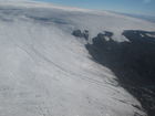
Gas concentrations in the Hofsjökull ice cave
Seismic swarm near Grímsey: update 15:00, 19 February
At 05:38 UTC this morning an earthquake of magnitude M5.2 occurred 14 km ENE of Grímsey. It was felt widely in the Northern part of the country. Five more earthquakes were detected. The earthquakes originate from the so-called Grímsey oblique rift zone in the northern Skálfandadjúp basin within the Tjörnes fracture zone.
Read more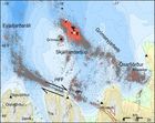
Grímsey earthquake swarm
Earthquake swarms are happening frequently in the vicinity of Grímsey. An earthquake swarm about 10-12 km North-East of Grímsey started on February 14. As of noon on February 16, over 1000 earthquakes have been detected
Read more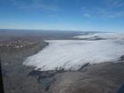
Ice cave in Hofsjökull – a warning
Ice caves are often found at glacier edges in Iceland, formed either by meltwater flow beneath the ice or by geothermal activity. News has recently been shared about a newly discovered ice cave in Blágnípujökull, where a child has collapsed due to breathing in toxic gases. The cave should not be entered without gas monitoring instruments.
Read more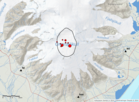
Earthquake 3.6 in the caldera of Öræfajökull
On the 9th February 2018 at 05:07, an earthquake of magnitude 3.6 occurred within the caldera of Öræfajökull volcano. Around 10 aftershocks have been recorded. The earthquake was felt by few people in the area, however most people slept through it.
Read more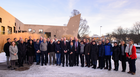
IMO's Involvement in WMO's Global Cryosphere Watch
Three years ago, the World Meteorological Organization approved the implementation of the Global Cryosphere Watch as a cross-cutting mechanism to bring together international observations and research of the world's cryosphere. Its data products and services are intended to support scientific progress and environmental policy developments related to the cryosphere, including snow cover, glaciers, ice caps, permafrost, sea ice, freshwater ice and icebergs around the globe.
Read more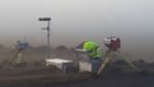
Final estimates of the emissions from the Holuhraun eruption based on ground-based measurements
Search
Contact IMO
© Veðurstofa Íslands | Bústaðavegi 7- 9 | 105 Reykjavík | Phone 522 6000 | Fax: 522 6001
Recording 902 0600 | SSN 630908-0350
Contact us | Employees | Terms and conditions | Sitemap


