
The volcano measured
No name yet
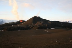
The Institute of Earth Sciences, University of Iceland, measured the size of the new volcano which has formed around the craters on Fimmvörðuháls.
The area of the new lava is now 1.3 square kilometers, the average thickness is 10-12 meters and estimated volume of eruptive material 22-24 million cubic meters (only one fifth of Hekla 2000).
Accordingly, the average flow rate has been approximately 15 cubic meters per second since the eruption began. The eruptive cone stands 82 m above previous ground level and the highest peak is 1067 m a.s.l.
On their web-site, explanatory photographs can be found (pdf 1.1 Mb), as well as an updated map showing the extent of the lava (pdf 1.4 Mb) and a series of images showing lava streams superimposed on a 3D view of the area (pdf 2.5 Mb).
Aerial photographs, taken by IMO's staff during flight with the Icelandic Coast guard, and taken by Ólafur Sigurjónsson who lives in Forsæti III nearby, show the progress of events during the first one or two weeks.


