
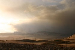
Ash carried southward and east
The eruption is now visible and can be watched on web-cameras and from satellites. The activity is ongoing and seismic tremor is restricted.
From midnight to 4:40 am numerous lightning strikes occurred from the plume. The cloud height is about 16,000 feet, periodically up to 24,000 feet.
Winds from the north carry the ash southward, where westely winds in the upper atmosphere carry it towards the east. The wind directions are not expected to change much during the next few days. Check London VAAC for further information. Click on the link "Issued graphics" above the map, and choose the most recent map.
Glacial floods will continue. A new gauging station has been installed near Þórólfsfell. No flood is occurring now. Forwarded data from the gauging stations can be viewed on the IMO web page.


