
Ash clouds and flash floods
Eruption flyby
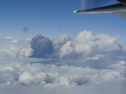
Staff from the Icelandic Meteorological Office flew with the Icelandic Coast Guard to the Eyjafjallajökull eruption site on the afternoon of April 16th 2010.
At 4 pm the volcanic ash cloud was clearly visible above the cloud deck, rising at times to at least 30,000 feet (9 km). Steady winds from the east-north-east moved the cloud away from the volcano.
The cloud height was variable from 25 to 30,000 feet and its colour varied from dark to white, depending on how much ash was in the cloud.

Away from the main cloud, the ash cloud narrows into a wedge:

The dark wedge that can be seen in the middle of the photo, is an ash cloud at 25 - 27,000 feet.
The plane also flew along the western side of Eyjafjallajökull but several flash floods have exited from the Gígjökull outlet glacier since the start of the eruption.

The above photo shows the outlet glacier, which is dark at the top due to mud from the flash floods. At the base the glacier flows to the right of a large cracked rock.

The above photo shows the rock in detail but in recent days a torrent of water has come through the crack during the flash floods. These have expanded the crack.
During late afternoon on April 15th a flash flood carried small ice bolders and mud unto the Markárfljótsaurar flood plane. The photo below shows an example of the remains of this flood.

For more news, click 2010.


