
Bad weather expected on Sunday
Remains of "Cristobal"
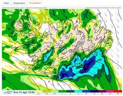
A deep and sharp low will approach Iceland from the southwest on Sunday, 31st August.
Southerly and southeasterly winds are expected, 25-25 m/s, and very strong gusts near mountains. Considerable precipitation will probably follow in all of the country, especially in the Southeast, but winds will calm down by evening.
Temperatures will be 10-15°C. This air-mass is warm and all the precipitation will be rain, even at the highest ice caps.
Since this is the first severe weather after the summer season, people are advised to check on their property and fasten loose objects. This low is the remains of "Cristobal" which caused damage in the Caribbean last week-end.
Written 29 August 2014 12:00 by meteorologists on duty: Birta Líf Kristinsdóttir and Þorsteinn V. Jónsson.
Additional remark from specialist in hydrology: The heaviest rainfall is expected around mountains and ice caps, where cumulative rainfall amounts will exceed 100 mm. Rising river levels are expected around the Eyjafjallajökull and Mýrdalsjökull ice caps, and south of the Vatnajökull ice cap. Travellers are cautioned against fording rivers in these regions.


