
Avalanches reported on the web
Last week's avalanches presented on a map
The avalanche warning service of the Icelandic Meteorological Office monitors impending avalanche danger in towns and villages in Iceland on a daily basis during the winter season. Real-time information about snowpack conditions and avalanche danger, that is gathered as a part of this monitoring, is potentially useful for inhabitants of rural areas and travellers on roads and in the backcountry.
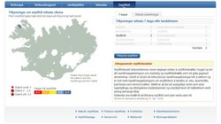
The IMO has made some of this information available on the web of the institute. Avalanches recorded during the past seven days are now presented in the form of a map and a table that show several key characteristics of each avalanche. The table lists avalanches reported during the past seven days or the last 24 hours classified according to geographical region.
One should keep in mind that most reports are from areas where the IMO employs avalanche observers and that many unreported avalanches may have fallen in other areas. Accordingly, people are encouraged to report avalanches that they come across using a specific internet form.
On the map, the size of an avalanche is given by the symbol, but the time elapsed since the avalanche fell is color coded. Further information about each avalanche appears when the the pointer is placed above the symbol.
General information about snow avalanches in Iceland is referred to through links below the map. An article including an explanation of the avalanche size classification is impending.

Heiðardalur above Reykir in Ólafsfjörður, 5 March 2010. Photo: Sveinn Brynjólfsson.


