
A large landslide falls in Hítardalur valley
The slide is considered among the largest landslides in historical time in Iceland
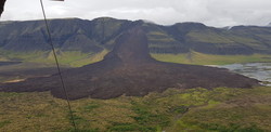
A large landslide fell in Fagraskógarfjall mountain in Hítardalur valley, W-Iceland, in the morning of July 7th. The landslide crossed the river Hítará, damming the river and causing a lake to form above the debris tongue. The water found a new channel the next day into Tálmi, a riverbed that reconnects with Hítará a few km farther downstream.
The landslide was detected by a seismograph at 05:17 in the morning of July 7th. A fox hunter in the area heard a landslide at around 23:30 in the night before and saw a slide in the area where the large landslide was subsequently released, but this slide did not reach the river. Therefore, it seems that a small landslide was first released from the mountainside, and then the main slide occurred ca. five hours later.
The debris is up to 20-30 m thick
The landslide fell from an area that showed evidence of earlier ground displacements and might be an old landslide deposit. The displaced material is a mixture of e.g. rock debris, scree from the lower part of the hillside, swamp soil and sediments from ancient lakes on the valley bottom. A preliminary estimate of the volume of the slide is 10–20 million m3. The area of the debris tongue is ca. 1,5 km2 and the debris is up to 20–30 m thick. The thickness is 5–10 m in many places near the margin of the tongue. The slide is considered among the largest landslides in historical time in Iceland. For reference, the rockslide in Askja that fell in July 2014 was around 20 million m3.
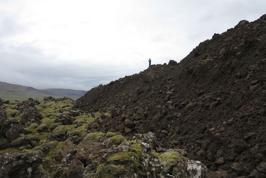
The thickness is 5–10 m in many places near the margin of the tongue. (Photo: Tómas Jóhannesson)
A weakness is thought to have existed in the mountain causing the mountainside to fail. It is also considered likely that rainfall and snowmelt in recent months have caused unusually high water pressure in cracks and fractures in the area which further weakened the starting area of the landslide.
The landslide causes considerable damage
The run-out angle of the landslide is 12–13° which means that the run-out is relatively long in comparison with other large landslides. The slide apparently swept with it scree material from a debris cone at the foot of the mountainside, and it appears that it travelled at high speed as it ploughed through a swamp, old lake sediments and soil on the valley bottom.
It remains to be seen how much damage was caused by the landslide. There is widespread damage of pasture areas and it is likely that sheep were buried by debris. Hítará is a known salmon river and the slide will change the hydrological conditions of the area, divert the river course and change the biological conditions for salmon. The owners of fishing rights may, thus, be faced with considerable loss.
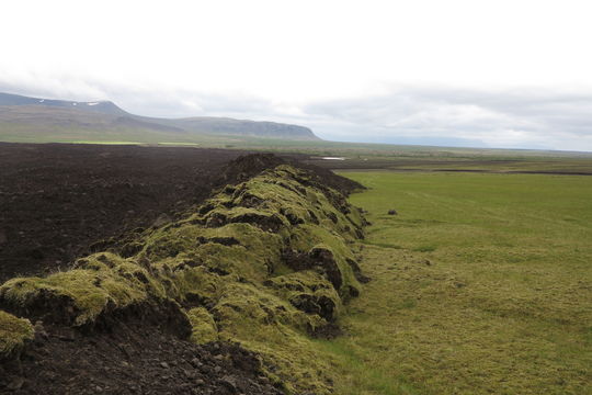
There is widespread damage of pasture areas and it is likely that sheep were buried by debris. (Photo: Tómas Jóhannesson.)
People should not travel close to the landslide area
A fracture was formed in the upper part of the mountainside NE of the crown of the landslide release area in connection with the slide. This fracture needs to be monitored for a while because of the danger of further slides. For the time being, it is not considered likely that another large landslide will be released from the mountainside. Rocks and small slides are, however, frequently released from the landslide source area at present. People should, therefore, not travel close the landslide area and the police has closed two gravel roads leading up to the slide.
The next steps in the study of this landslide will be to process measurements that have been carried out and analyse aerial photographs as well as other photographs from the area, both before and after the slide. This will make it possible to refine the volume estimate as well as shed light on the release mechanism and the general nature of the slide.
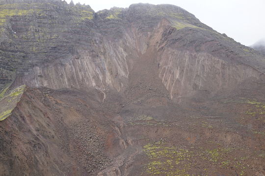
A fracture was formed in the upper part of the mountainside NE of the crown of the landslide release area in connection with the slide. (Photo: Oddur Sigurðsson)


