
Displacements in Fagraskógarfjall for some time before the landslide fell
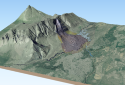
A digital elevation model (DEM) reveals the scale of the landslide
A large landslide fell from Fagraskógarfjall mountain in Hítardalur valley, W-Iceland, in the morning of July 7th, 2018. The landslide crossed the river Hítará, damming the river and causing a lake to form above the debris tongue. A link to a former news piece on the landslide is here.
A digital elevation model (DEM) of the landslide has been created based on aerial photographs taken from a helicopter, GPS measurements as well as data from terrestrial laser scanner (TLS). A short video, showing the landslide from various angles can be seen here .
A preliminary estimate of the landslide volume has been made based on a comparison between the new DEM and an older DEM from before the landslide. The results indicate that about 7 million m3 of material is “missing” from the source area which might be the approximate volume of material that was released initially when the slide started. The landslide entrained more material on the way down the mountainside, and the elevation of the debris tongue on the valley bottom is about 10 million m3 greater than the terrain elevation before the slide. Field observations show that the landslide ploughed through sediments at the foot of the mountain and on the valley bottom and, therefore, the debris tongue probably reaches several metres below the former terrain. It is not easy to estimate the volume of the part of the landslide that lies below the former terrain, but the total slide volume might be 10–20 million m3, when everything is counted. Further analysis of the landslide volume is ongoing.
Displacements in Fagraskógarfjall before the landslide fell
Sentinel-1 satellite radar images show displacement in the starting area before the landslide occurred according to InSAR analysis by Vincent Drouin at the University of Iceland and the National Land Survey of Iceland. The mountainside in the starting area of the landslide is different from the surrounding slopes according to an interferometric analysis of the radar images. The displacement in the last days before the landslide was at least a few centimetres. The starting area also appears to have been moving in 2017, 2016, and 2015 but at a slower rate.
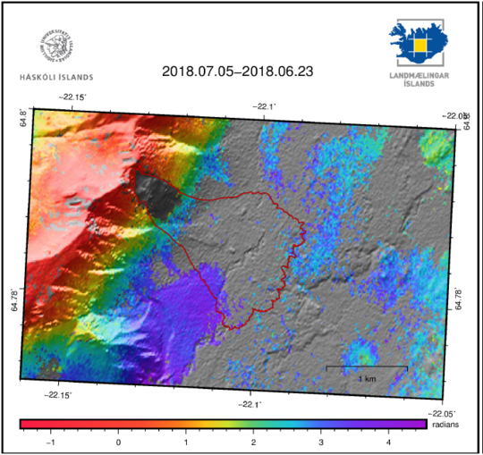
Sentinel-1 satellite interferogram from June 23th to July 5th 2018. The colour scale shows changes over the time period, mostly caused by atmosphere variations in this case. Grey areas denoted areas where the ground surface has changed more than is possible to detect with this technique. In the case of the valley floor in Hítardalur being grey, the growing vegetation is believed to be the cause. In the case of the source of the landslide, it is the only part of the mountain slope which is grey. This suggests that rapid deformation was ongoing between the two acquisitions in the area while the surrounding slopes were stable. (Figure from Vincent Drouin, University of Iceland and the National Land Survey of Iceland).
This detection of movement before the Hítardalur landslide fell indicates that large landslide may be associated with precursors that could be detected by satellite data or other measurements. Hopefully, it will be possible to analyse slopes above settlements and frequently travelled areas where instability is suspected, and detect areas where displacement is occurring. Such areas could then be monitored in near real-time with the same technology.
However, it is difficult to decide when the rate of displacement is high enough for a landslide to be imminent. Furthermore, areas that are moving differ from one to another. In some cases, fractures are close to the edge of mountaintops, causing the rim to break up in small pieces that are released as small slides. In other cases, surface sediments are fractured and moving even though there are no faults in the underlying bedrock. In those areas, a landslide could be released from the sediments but a large rockslide is not expected. And in some places, fractures reach deep into the bedrock and large volumes of rock could be released as a catastrophic rockslide.
Large landslides and climate change
Several large landslides have been released in Iceland in the last few years and it has been suggested that large landslides are becoming more frequent due to climate warming. However, it is not possible to determine whether this is indeed the case since the events are too few for a change to be statistically significant.
Climate change could possibly increase landslide danger for three different types of slides:
- Landslides can be released where mountainsides become unstable due to melting of permafrost.
- Landslides due to heavy rain and snowmelt may become more frequent since warmer winters and increased rain intensity may be expected in warmer climate.
- Landslides and rockslides may become more frequent where glaciers have receded and thinned so that the lateral support of the adjacent mountainsides is diminished.
It is considered unlikely that the landslide in Fagraskógarfjall was caused by melting permafrost
Infrared thermal images were taken of the landslide and the source area with a camera from the Earth Science Institute of the University of Iceland. If permafrost were present in the source area or pieces of permafrost material had been in the debris tongue, the thermal images would have shown areas close to the freezing point, especially where water was leaking out from cracks in the starting area. Such areas near the freezing point were not observed and, therefore, the cause of the landslide is not believed to be thawing permafrost. Furthermore, the hill is not very high (the highest point is 680 m a.s.l.) and it faces SE. Permafrost is believed to be hidden in some areas in higher slopes and/or shady north-facing slopes where permafrost is sometimes found in and beneath loose materials.


