
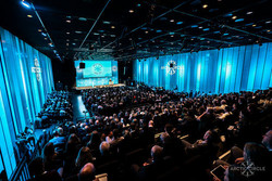
Glacier change sessions at this year's Arctic Circle Assembly
Changes in the area and volume of ice and snow are strong indicators of global warming and nowhere are such changes more visible than in the Arctic, where the warming rate is presently twice as high as the global average. At this year's Arctic Circle Assembly, scientists from the Icelandic Meteorological Office (IMO) led sessions and workshops on melting glaciers in the Arctic region. This is one of four topics that will be highlighted during Iceland's chairmanship of the Arctic Council in 2019–2021. The session was organized in cooperation with the Icelandic Arctic Cooperation Network (Norðurslóðanetið) and the International Arctic Science Committee (IASC).
Rapid mass-loss from Arctic glaciers
Some of the largest glaciated areas on Earth are located in the Arctic and sub-Arctic regions, including Alaska, Arctic Canada, Svalbard, the Russian Arctic islands and
Iceland. The Greenland Ice sheet, which is the second largest ice mass on the
planet after Antarctica, is also located in the region. At this year's Arctic
Circle Assembly, IMO organized a special session titled: Arctic glaciers and
ice caps: Recent changes and contributions to sea-level rise. Nearly all glaciers in the above-mentioned regions are now losing
mass, and more than half of the contribution to global sea-level rise from land-based
glaciers orginates from the Arctic.
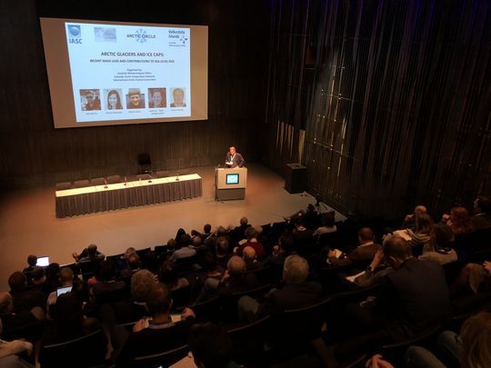
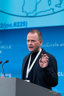
The session on Arctic glaciers and ice caps was chaired by
Thorsteinn Thorsteinsson, glaciologist at IMO. (Photo: IMO)
Martin Sharp (University of Alberta, Canada), presented results on mass loss from glaciers and ice caps in Arctic Canada, where the ice cover totals 146 thousand km2. The total ice volume is tenfold the volume of glaciers in Iceland and the estimated mass loss during 2006–2015 was 70 gigatons (GT) per year. Barbara Barzycka from the Polish Centre for Polar Studies, University of Katowice, discussed the mass balance of glaciers in Svalbard, where the rate of warming exceeds many other parts of the world. The mean annual temperature in the archipelago has risen by 3–5°C in the period 1971–2018 and the estimated annual mass loss from glaciers in Svalbard during 2006–2015 is 9 GT/year. This is approximately 50% higher than the annual mass loss from ice caps in Iceland, according to measurements by IMO and the Institute of Earth Sciences (IES). Guðfinna Aðalgeirsdóttir (IES; University of Iceland), presented the results from Iceland, discussed data on glacier front variations collected by the Icelandic Glaciological Society and outlined new modelling results of the future fate of the Vatnajökull ice cap. René Forsberg from the Technical University of Denmark (DTU-Space) discussed methods used to evaluate the recent mass-balance of the Greenland Ice Sheet, with a focus on data from the GRACE and GRACE-FO satellites, which measure the gravity field over Greenland. The data allow estimates of mass loss and results indicate that the Greenland Ice Sheet is the single largest contributor of meltwater from land ice to sea-level rise, delivering 0.8 mm/year during 2006–2015. Paul Morin from the University of Minnesota (USA) gave a presentation on a new digital elevation model of the entire Arctic region north of 60°N, known as the ArcticDEM, created from satellite data during the US chairmanship of the Arctic Council in 2015–17. Morin led the work on the new model at the Polar Geospatial Centre and data from the WorldView satellites were also used to make the most detailed map available of the surface of Antarctica.
.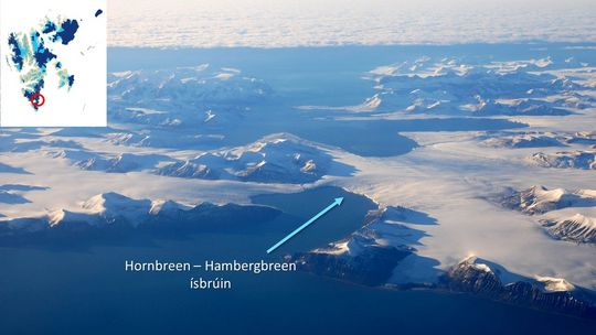
The ice bridge between the two glaciers Hornbreen and Hambergbreen in Southern Svalbard. The glaciers are in retreat and the ice bridge has been projected to break up in the period 2055-2065, thereby separating the southernmost island from other parts of the archipelago. (Photo; Fr. Marek Michalski).
A new accurate high-resolution digital elevation model of Iceland
A special workshop on the use of the above-mentioned ArcticDEM and upcoming new data to monitor glacier changes was organized by IMO during the Arctic Circle Assembly, with participation from universities and surveying institutes in Austria, Canada, Denmark, Greenland, Norway, Iceland and the US. The aim is to measure changes in the surface elevation of glaciers in selected regions of the Arctic and sub-Arctic since 2010 and thereby calculate their mass loss. The new maps of glaciers created from ArcticDEM data can serve as a benchmark against which future changes will be compared. The workshop was moderated by Tómas Jóhannesson, glaciologist at IMO.
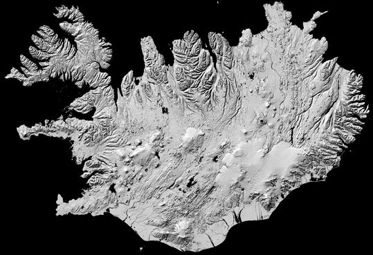
The digital elevation model of Iceland that is being produced from ArcticDEM data will have a 2x2 m horizontal resolution and the vertical accuracy will likely be better than 0.5–1 m. The figure shows a preliminary shaded version of the model, created in a collaboration between the National Land Survey of Iceland, Icelandic Meteorological Office and Polar Geospatial Centre, 2019.
Arctic climate change can influence climate in other regions
 Halldór Björnsson, leader of the atmospheric research group at IMO, gave a presentation during the plenary session “Arctic Tipping Points”. He outlined examples of how Arctic warming seems to be affecting weather conditions in regions far away from the Arctic. As the Arctic warms, the temperature gradient between temperate and Arctic regions decreases and spatial fluctuations in the boundary between cold and warm air can increase in amplitude. Cold air can reach far south in exchange for warmer air that flows into the Arctic regions. In this same session, Stefan Rahmstorf from the University of Potsdam talked about the possible slowdown of deepwater formation north and southwest of Iceland, due to increased melting of the Greenland ice sheet, that might weaken the transport of heat with the Gulf Stream to the North Atlantic region. Antje Boetius, director of Germany‘s Alfred Wegener Institute, focused on tipping points in Arctic ecosystems in her presentation. The session was chaired by Brynhildur Davíðsdóttir, University of Iceland.
Arctic Observing Networks
IMO's director, Árni Snorrason, gave a presentation in a session titled: Defining a road map for Arctic observing, organized by the SAON collaboration ( Sustaining Arctic Ocean Networks ). Dr. Snorrason's lecture focussed on the contributions of national hydrological and meteorological institutes to Arctic observations. He also described a new monitoring program operated by the World Meteorological Organization (WMO), The Global Cryosphere Watch (GCW). Presently, about 160 stations belonging to GCW's station network, CryoNet, are in operation on all seven continents, collecting data on all components of the cryosphere. A quarter of the CryoNet stations are located in the Arctic and sub-Arctic regions.


