

Minor jökulhlaup in Grímsvötn
Aviation color code raised from green to yellow. Examples of volcanic eruptions in Grímsvötn coinsiding with glacial floods.
Updated 13.10.
The glacial flood from Grímsvötn is still ongoing and maximum discharge of about 500 m3/s from Grímsvötn sub-glacial lake is expected to be reached later today or tonight. The ice-shelf on top of the sub-glacial lake has now subsided approximately 12 m since 5th of October. Since yesterday morning signals of floodwater have been detected in Gígjukvísl river by water level measurements and on images from a web camera. The discharge in Gígjukvísl river is expected to continue to increase and reach maximum discharge a day later than maximum discharge from Grímsvötn, which is approximately the time it takes the flood water to flow from Grímsvötn to Skeiðarársandur as shown on the following map. The maximum discharge in Gígjukvísl expected in this flood is similar to maximum discharge during peak summer melt on the glacier and will therefore not affect any infrastructure such as roads or bridges.
No significant changes have been observed in seismic activity at Grímsvötn volcano during this flood event. The Icelandic Met Office together with the scientists at IES continue to monitor Grímsvötn and will publish information depending on the development of the scenario.
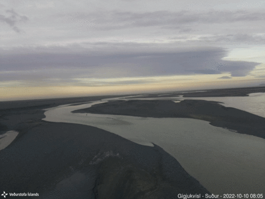
A series of picture
from a web camera located on the bridge over Gígjukvísl on road no. 1. The
pictures show an increase in discharge from 10th to 13th of October.

The map shows approximately the floods pathway underneath the glacier. It is assumed that the maximum discharge in Gígjukvísl river will be lower than the maximum discharge from Grímsvötn because it will be affected by the lagoons in front Skeiðarárjökull glacier. The flood pathway outside the glacier is marked by the black line and VHM159 is the water level station at Gígjukvísl. (Map by Bogi Brynjar Björnsson)
Updated 10.10
Measurements by the Institute of Earth Sciences, University of Iceland, indicate that water has started to flow from Grímsvötn within the Vatnajökull glacier and a glacial flood is expected in Gígjukvísl outlet river. The ice sheet has receded by almost 3m in the last few days, but the water level is low in Grímsvötn, so a small flood is expected, or a fifth the volume of the last flood. It is most likely that the flood will start in Gígjukvísl tomorrow, Tuesday, and last for several days. If the Grímsvötn subglacial lake will drain completely, the ice shelf can likely sink by some 10-15m in total.
The
last flood from Grímsvötn was in December last year, so it's been a short time
since the last flood. Measurements of the water level in Grímsvötn indicate
that the maximum flow of the stream now will be low, or around 500 m3/s,
compared to last year the flow which reached almost 3,000 m3/s. Last
years flood had little or no effect on infrastructure, e.g. roads and bridges.

Graph showing how much the ice sheet has receded since the beginning of October this year. (Click on the image for a larger view)
Volcanic activity monitored closely
There
are examples of volcanic eruptions in Grímsvötn coinsiding with glacial floods.
It is likely that the sudden pressure relief due to decreasing water level can trigger
eruptions. The last time such a scenario happened was in 2004, and before that
in 1934 and 1922. However, Grímsvötn have much more often had floods without an
eruption. However, the flight color code for Grímsvötn has been changed to
yellow due to the run, as it is difficult to rule out the possibility that an
eruption will start as a result, although it is considered unlikely. Two things
need to happen; pressure relief has to be enough to "trigger" and
wake up the volcano, and magma pressure within the volcano has to be enough to
set off an eruption, but there is uncertainty about both aspects. The maximum
pressure relief in Grímsvötn can be expected on Wednesday, when the flood
reaches its peak, and with it an increased chance of an eruption, which will
quickly decrease after the flood.
The
Icelandic Met Office together with the scientists at IES continue to
monitor Grímsvötn and will publish information depending on the development of
the scenario. In light of this, it is worth pointing out that along with
glacial flood water, gas pollution can be expected, which will be highest near
the glacier edge at the outlet and at the riverbed of Gígjukvísl.
More about the volcano Grímsvötn
Grímsvötn
is the most active volcano in Iceland, and commonly has eruptions every 5-10
years. About 20 eruptions have occurred in Grímsvötn and the surrounding area
in the last 200 years. The last eruption in Grímsvötn was in 2011 and it was
quite large and powerful, but otherwise the last few eruptions have been rather
small and lasted for a few days. More information about the volcano can be
found at the Icelandic volcanoes website, https://icelandicvolcanoes.is/ .


