
Monitoring of Hekla
Of the thirty active volcanic systems in Iceland, Hekla is one of the most active and potentially dangerous. In this summary we outline the types of hazards that might occur during the next Hekla eruption, and how the Icelandic Meteorological Office (IMO) is monitoring the region.
The hazards associated with each volcano are related to the type, location and intensity of an eruption. Public vulnerability to volcanic hazards increases as the number of people exposed to the hazard grows. A key issue in mitigating volcanic risk is the capability to detect, interpret, and communicate volcanic signals before and during a volcanic eruption.
Historical activity and possible hazards
During the last millennium, Hekla has erupted 23 times, making it the third most active volcano in Iceland. Hekla's most recent eruption was in February 2000, when a 10 to 12-km-high plume of ash, gas and water vapour persisted for a couple of hours. The most recent major eruption of Hekla in 1947 created a volcanic plume that rose to about 30 km in the stratosphere. Hekla eruptions often result in multiple hazards, including tephra emissions, lava flows, pyroclastic flows and flooding due to snow-melt. Depending on weather conditions at the time of the next eruption, fine-grained ash could be lofted to high elevation, with international implications for air travel. Since 1970, the volcano has erupted at roughly decadal intervals (1970, 1980-81, 1991 and 2000). This is one reason why the volcano is now considered to be ‘overdue', as the last eruption occurred more than 16 years ago. Before 1970, Hekla erupted less frequently, with repose intervals up to 120 years in past centuries. An overview of Hekla´s activity is available from the Catalogue of Icelandic Volcanoes .
Monitoring network and warning system operated by IMO
Since instrumental monitoring of Hekla began in the seventies, pre-eruptive signals have been detected only tens of minutes before an eruption commenced. Great efforts continue to be made to operate and expand a robust monitoring network on and around Hekla for the purpose of detecting precursory eruptive signals. The goal is to optimize the observation and interpretation of the available signals to allow a timely warning about volcanic activity. Such a warning would be issued to major stakeholders (Iceland's Civil Protection Department, Isavia and London VAAC) and to the public. In addition to the extended seismic (SIL) network, the monitoring network around Hekla includes instruments that detect ground deformation (GPS and borehole strain meters), volcanic gases (DOAS and MultiGAS) and fixed sites for web-camera observations. As in 1991 and 2000, the next eruption of Hekla should be preceded by the measurable propagation of magma towards the Earth's surface; this process should be detected initially by two nearby borehole strain meters (Figure 1). Earthquakes accompanying the ascent of magma should also be detected in near-real-time. Improvements in the SIL network in recent years allow for the detection of smaller, and thus many more earthquakes, as well as enabling better constrain on earthquake location and depth (Figure 1). Additionally, the onset of the next eruption will be identified using nearby infrasound sensors that detect volcanic explosions and radar (for ash-cloud detection), which will further help to assess the intensity of the eruption.
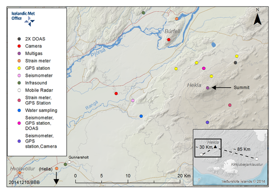
Figure 1. Current monitoring network configuration around Hekla. Different types of instrumentation are installed within 15 km from the summit. Some of them are for pre-eruptive monitoring and others are used to monitor an ongoing eruption.
The seismic network was improved in 2010 with the installation of two temporary broadband seismometers within 11 km of the volcano; these stations were added to the permanent network in 2012. To date, seismometers in the region are able to detect all earthquakes above magnitude 0.9, whereas in 2000 – when Hekla last erupted – this threshold was around 2.2. Figure 2 shows a Gutenberg-Richter distribution for earthquake magnitudes detected by the SIL system between 1996 and 2000 and for 2012 to 2016. The present network is able to detect much smaller earthquakes than would have been detected automatically immediately before the 2000 eruption; moreover, their location accuracy is expected to be greatly improved.
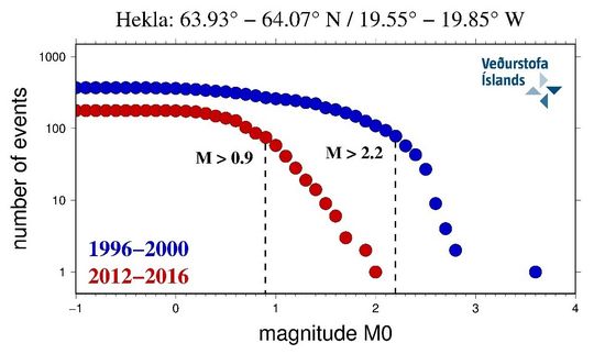
Figure 2. Gutenberg-Richter distribution, showing the number of earthquakes in 0.1 magnitude intervals for the periods 1996-2000 (blue) and 2012-2016 (red). Note how the minimum magnitude of completeness (dashed, vertical lines) above which all earthquakes within the region are reliably recorded has improved since 2000.
Increased earthquake activity at Hekla results in an automated audio warning in IMO's monitoring room in Reykjavík, which is staffed around the clock every day of the year. The warning system, which is used for all regions in Iceland, is based on earthquake size, earthquake rate and energy release relative to predefined thresholds. In addition to an audio alert for Hekla, an SMS alert is sent to IMO monitoring coordinators, Civil Protection and Isavia, as well as others. Other near-real-time monitoring products are available in IMO's monitoring room, including automated plots of borehole strain data integrated with Hekla seismicity, which are updated every 5 minutes. Seismic tremor is also monitored and a warning is issued every time the tremor at any station exceeds a threshold which might indicate eruption tremor. In addition to these improvements, regular eruption exercises (VOLCICE and VOLCEX) are held monthly with Isavia and London VAAC. These exercises help to train staff to respond to an eruption, and they also improve communication between institutes.
Current status of Hekla volcano
Three main parameters are monitored by IMO: seismicity, surface deformation, and gas emissions. Figure 3 shows an almost constant rate of the number of detected earthquakes and the cumulative seismic moment during the last 3.5 years.
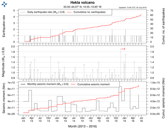 Figure 3. Overview of seismicity at Hekla from January 2013 to early July 2016. Both the cumulative number of earthquakes and the cumulative seismic moment show a near-constant trend, reflecting background conditions at the volcano.
The most recent deformation measurements made by colleagues from the University of Iceland and the University of Gothenburg (mostly lead by Prof. Erik Sturkell, Prof. Páll Einarsson, Ásta Rut Hjartardóttir and Halldór Ólafsson) are shown in Figure. 4. The plot shows the east component of tilt measurements made at Næfurholt, which has been representative of Hekla´s inflation/deflation eruption cycles since 1985. The trend interpreted as inflation shows a broadly constant, long-term trend signal 2000. The 2000 eruption level was exceeded sometime between 2007 and 2009.
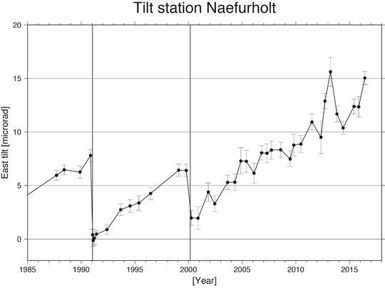 Figure 4. Overview of changes in tilt at Hekla as measured at a site in Næfurholt. The plot covers the period since 1985 and it includes the last two eruptions (represented by a sudden deflation of the edifice). Changes in tilt at Næfurholt have been interpreted as signs of steady inflation since 2000, and have now significantly overpassed the level before the 2000 eruption.
Gas measurements made at Rauðaskál using DOAS have seen no detectable concentrations of SO2 emitted by Hekla since measurements began in 2014. The detection of SO2 is anticipated to be a signal of magma moving closer to the surface.
Conclusion and recommendations
Since the 2000 eruption of Hekla, significant improvements have been made to IMO's monitoring networks around the volcano. It is hoped that these networks will, collectively, allow for a timely eruption warning, allowing steps to be taken to mitigate the impact of the eruption. However, due to harsh environmental conditions around Hekla, together with the potential for data-transfer and handling problems, a definite, short-term forecast cannot be guaranteed. Although unlikely, the next eruption of Hekla could occur with little or no forewarning, despite having all monitoring and warning systems fully functional. For sightseers on and around Hekla, the potential for explosive volcanism must be kept in mind. At close-range, an eruption of Hekla would produce a variety of lethal hazards, including incandescent (pyroclastic) flows of lava fragments, ash and gas. Taking into account IMO's improved monitoring capabilities, and based on the behaviour of Hekla in 1991 and 2000, the unpredictability of the volcano is such that the warning-time under optimal conditions could be less than an hour.


