
News
Upptök jarðskjálftans í Ölfusi
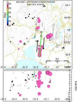
Outline of the earthquake fault in Ölfus
The map shows the location of the damaging earthquake that struck yesterday afternoon. Most movement took place along the fault shown in green.
The black arrows denote right-lateral, strike-slip faulting. The same type of faulting took place during the June 2000 earthquake sequence in southern Iceland.
The star denotes the source of the large earthquake that occurred south-west of Ingólfsfjall.
Significant earthquake activity has taken place west of the main fault; this is the location where a magnitude 5 earthquake occurred in November 1998, making it unlikely that a large earthquake will occur in this region.
The lower plot shows the corresponding focal depth of the epicentres shown in the map.


