
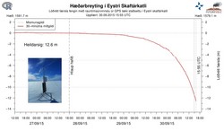
Ice surface lowering - striking graph
Glacial outburst flood in Skaftá imminent
Floodwater continues to drain from the eastern Skaftá ice-cauldron. The latest GPS measurements show that the rate of ice-surface lowering (subsidence) continues to increase. This can now be observed on the web on a graph that updates every five minutes.
At the time of writing (16:00), the level of subsidence exceeds 12 m but this represents only 10% of the expected total. In the coming days, the rate of subsidence will continue to increase. It is possible that radio contact will soon be lost with the GPS station, as subsidence will disrupt the line-of-sight for the radio link.
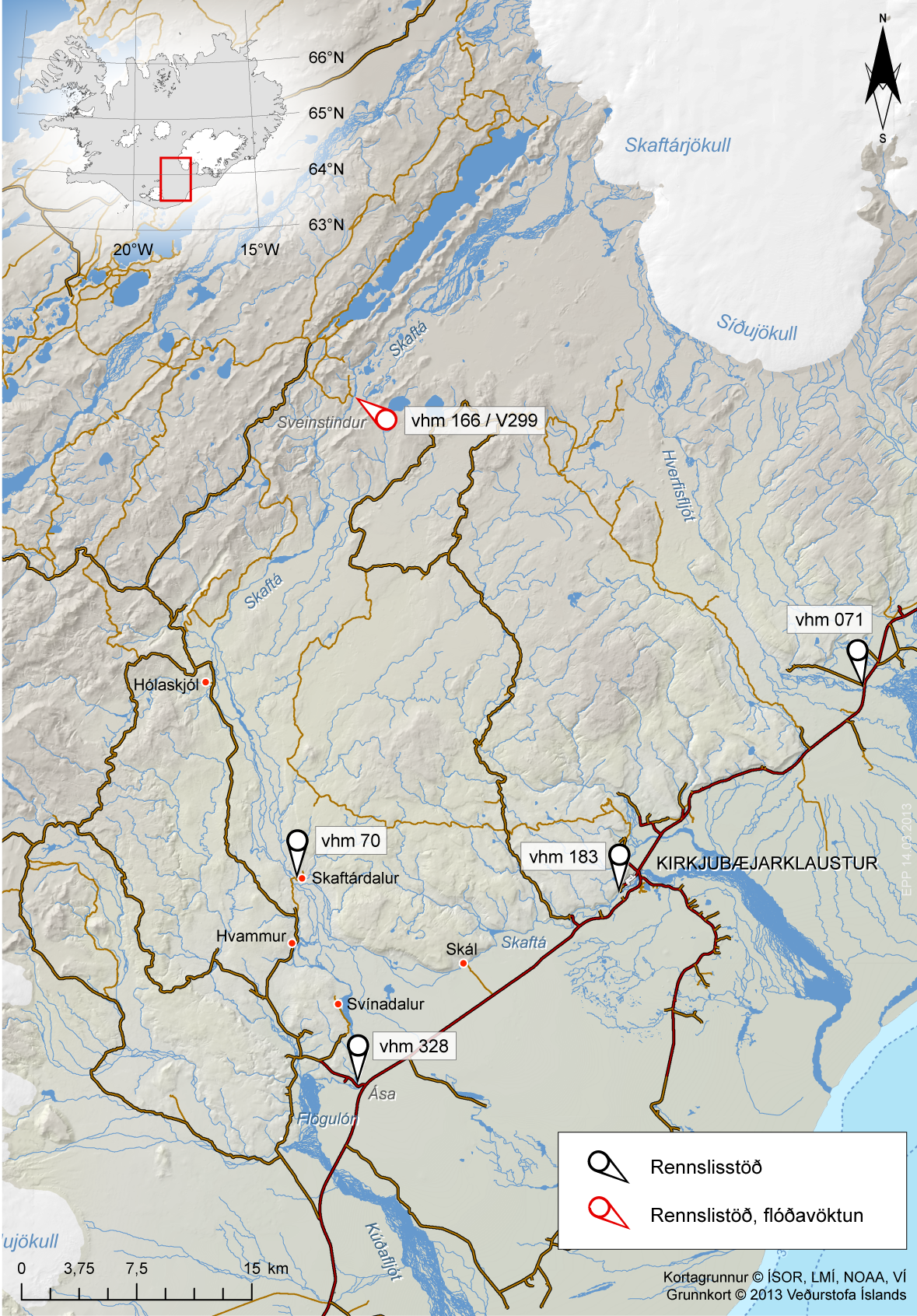
Floodwater is propagating beneath western Vatnajökull to the Skaftá river, where it is likely to emerge early on Thursday morning, 01 October. From there, the jökulhlaup will take about 4 hours to reach the nearest gauging station at Sveinstindur. The rate of water-level increase at Sveinstindur will allow us to estimate the size of the flood as it develops. Localised flooding should be expected on the lower part of Skaftá late on Thursday, lasting through the weekend.
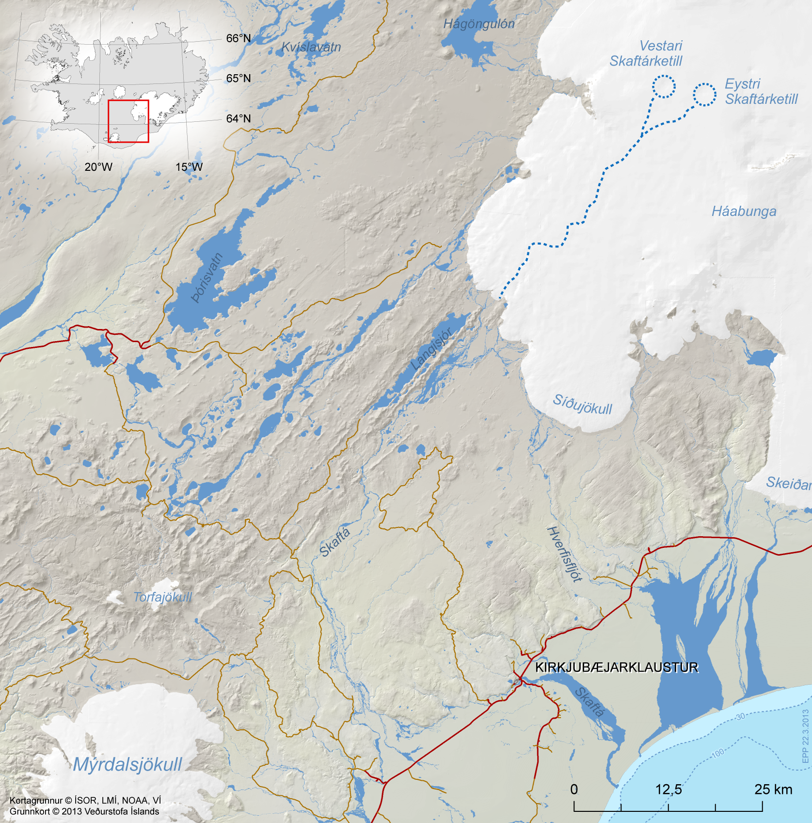
For latest information, see Remarks of a specialist (in red) on the Hydrology front page. See also regional map and gauging stations. The latter map shows also five inhabited places which are likely to be affected (small red dots).
Possible hazards
- Flood conditions are expected on Skaftá from the early hours of Thursday (01 October) to at least Sunday (04 October). Some flooding of unpaved roads close to Skaftá is possible.
- Although unlikely, the flood might drain partly from Síðujökull, which would cause flooding on Hverfisfljót, particularly at the bridge over Highway 1.
- Hydrogen sulphide is released from the floodwater as it drains from Vatnajökull. The gas is particularly potent at the ice margin, where concentrations will reach poisonous levels. Travellers must stay away from the edges of Skaftárjökull, Tungnaárjökull and Síðujökull while the jökulhlaup occurs.
- Crevasses will develop rapidly around the ice cauldron, so travellers on Vatnajökull should stay away from the region, including the lower part of Skaftárjökull and Tungnárjökull, where floodwater could burst through the surface.
For latest information, see Remarks of a specialist (in red) on the Hydrology front page.
Background
Jökulhlaups in Skaftá are sourced from two ice cauldrons, formed due to persistent geothermal activity beneath Vatnajökull. On average, the cauldrons drain every two years, producing floods of up to 1,500 cubic metres per second. When the interval between floods is short the flood tends to be smaller. The eastern cauldron is responsible for the largest floods.


