
The August glacial outburst - one of the larger jökulhlaups to have affected Skaftá in recent decades
Accurate early warning to the public, based on innovative GPS measurements in the cauldron
Jökulhlaups in the river Skaftá are sourced from two subglacial lakes, formed due to persistent geothermal activity beneath Vatnajökull. This activity is apparent on the ice-surface as a circular depression, known as an ice cauldron. On average, the two neighbouring cauldrons drain every one to two years, producing floods ranging in maximum discharge from hundreds to occasionally thousands of cubic metres per second. When the interval between floods is short the flood tends to be smaller, with the eastern cauldron responsible for the largest floods.
Accurate early warning to the public, based on innovative
GPS measurements in the cauldron
The beginning of the August jökulhlaup was registered by continuous GPS measurements of the ice-shelf over the eastern cauldron. These measurements showed a slight lowering early on 31 July 2018, marking the onset of flooding beneath Vatnajökull. The progressive subsidence of the ice-surface was monitored closely and, as the lowering approached 1 m, a public warning was issued by IMO at 16:35 UTC on 2 August 2018. This warning stated the expected development of the jökulhlaup and the approximate timing of flooding in the lowlands; likely hazards were also outlined, focussing on the extent of flooding and gas pollution near to the source of Skaftá. The initial warning came around 20 hours in advance of floodwater reaching Sveinstindur – the uppermost gauging station on Skaftá, located 25 km downstream from Vatnajökull. The advanced warning allowed the emergency services and landowners to take proactive steps to reduce the impact of the jökulhlaup. For instance, highland roads near to Skaftá were closed and livestock were moved to higher ground. The initial public warning was updated daily during the four days of the jökulhlaup and there was close collaboration with the Department of Civil Protection and Emergency Management, the Icelandic Association for Search and Rescue, and the Icelandic Coast Guard.
One of the larger jökulhlaups to
have affected Skaftá in recent decades
The jökulhlaup peaked at Sveinstindur at around 00:00 UTC on 5 August, having reached a discharge of approximately 2,000 cubic metres per second. In terms of discharge, the August jökulhlaup is one of the larger floods to have affected Skaftá in recent decades. However, with a maximum discharge of 3,000 cubic metres per second, the October 2015 jökulhlaup remains the largest and most damaging flood to have affected Skaftá since the mid-1950s.
Jökulhlaup
sourced from two subglacial lakes
During the recession of the jökulhlaup it became apparent that the subglacial lake below the western cauldron had also drained, which had the effect of prolonging the flood. Downstream the two flood-peaks were over 24 hours apart and the contribution of the western cauldron was estimated at around a third of the overall flood volume. Based on discharge measurements at Sveinstindur, the volume of water drained from both cauldrons is thought to be 435 billion litres (435 Gl). For comparison, a bowl-shaped football stadium, such as Wembley Stadium in the UK, has a volume of 1.1 Gl, so the August 2018 jökulhlaup had a volume of almost 400 Wembley stadia. This estimate excludes the actual baseflow of Skaftá at Sveinstindur, which is thought to have been 65 billion litres (65 Gl) during the four-day flood.
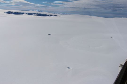
The eastern cauldron on 6th July 2018, before the outburst. Photo: Þorsteinn Þorsteinsson.
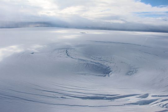
The eastern cauldron on the 4th August, towards the end of the flood, showing dramatic changes in the ice-shelf. Photo: Þorsteinn Þorsteinsson
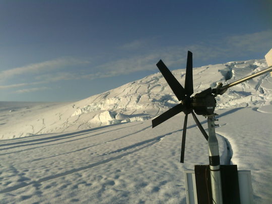
Web camera at the GPS station, showing collapse of the ice-surface.
Infilling of lava fields by fine sediment,
resulting in stream contamination and sandstorms
During the height of the flood, fine-grained sediment was deposited on young, porous lava fields adjacent to the river, both in the highlands and the lowlands. Such sedimentation progressively fills the lava, allowing subsequent jökulhlaups to expand further beyond the river. The infiltration of glacial water into the lava fields has implications for groundwater conditions and the contamination of nearby spring-fed streams such as Grenlækur and Tungulækur. Fine sediments can also create secondary, long-term problems such as sandstorms during windy conditions.
Localised water-flow across Iceland's national highway, leading to travel disruption
Aerial photographs and satellite imagery show that extent of the August jökulhlaup was less than the October 2015 flood. However, the August flood remobilised sediment from 2015, which was deposited farther downstream, close to the national highway. As sediment accumulated in the lava, floodwater was able to overtop a 500 m section of the road, forcing its partial closure from 6 – 8 August.
In response to the October 2015 jökulhlaup, IMO has recently completed an assessment of jökulhlaup hazards on Skaftá. The findings of this state-funded project are documented in five reports that contain English summaries. The results of the project will be used as a long-term basis for estimating the downstream impact of jökulhlaups in Skaftá.
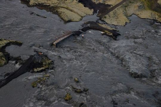
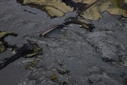
The bridge in Skaftárdalur inundated by floodwater on 4th August. Photo: Benedikt G. Ófeigsson


