
Eruption has started in Grímsvötn
An eruption began at Grímsvötn volcano at approximately 17:30 UTC, May 21st 2011.
Eruptions in Grímsvötn start as subglacial eruptions, which quickly break the ice cover. At 21:00 UTC, the eruption plume had risen to an altitude of over 65,000 ft (~20 km). Initially, the plume is expected to drift to the east and subsequently to the north. Thus, the ash is not expected to impact aviation in Europe, at least not during the first 24 hours.
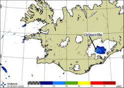
The figure on the right (above) shows an image of the eruption cloud at 22:00 UTC. The image is from the Icelandic Met Office weather radar located at Keflavik International Airport, at 220 km distance from the volcano. The cloud extends above a large part of Vatnajökull ice cap. The line marks the approximate location of Grímsvötn volcano.
The last eruption in Grímsvötn occurred in November 2004. Grímsvötn is Iceland's most frequently erupting volcano.
The figure below shows tremor activity in Grímsvötn associated with the eruption. Note that seismic activity increases after 17:30 UTC. Also, a description of seismic activity at volcanoes in Vatnajökull ice cap is available (pdf 2.2 Mb).


