
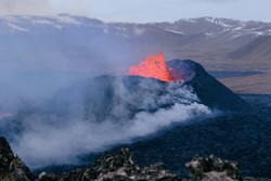
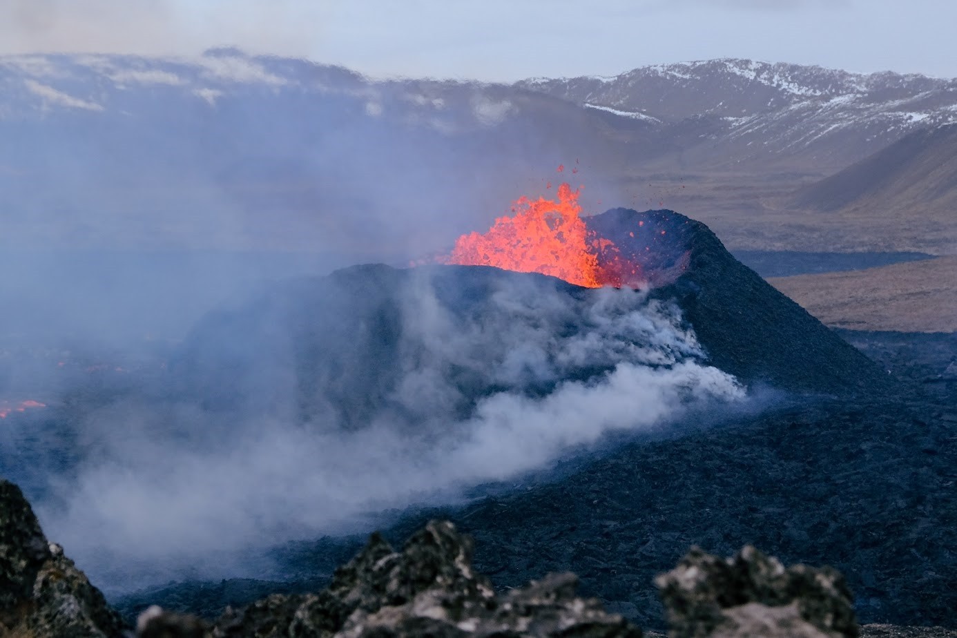
The eruption continues in Sundhnúkur crater row
The lava field is becoming thicker close to the barrier East of Grindavík
Updated 23. April at 18:00 UTC
The eruption continues from the single vent which formed just East of Sundhnúkur, in a similar manner since 5 April. Lava continues to extrude and propagate towards the South along open channels, which are clearly visible from the cameras. The lava is also travelling longer distances from the crater through a network of closed tubes, which prevents the lava from cooling by direct contact with the atmosphere. The sector of the lava field which has been propagating towards the South, and reached the protective barriers built East of Grindavík town, has been thickening in the past few days, as shown in the images below. The images show the differences in the lava field profile between 18 and 23 April. The image at the top is taken from the camera owned by the Icelandic Civil Protection which is located at the barrier East of Grindavík and looks toward the part of the lava field which propagated towards Suðurstandavegur at the beginning of the eruption. The image at the bottom is also from a camera owned by the Icelandic Civil Protection and it is located on top of Hagafell hill and is oriented to the South.
Estimates of the lava
extrusion rate show values between 3-4 m3/s since the beginning of April. The
last measurements were made on 15 April, so we are now waiting for new
acquisitions which will be available next week, to shed light on the level of
the current activity and to understand if there have been any significant changes.
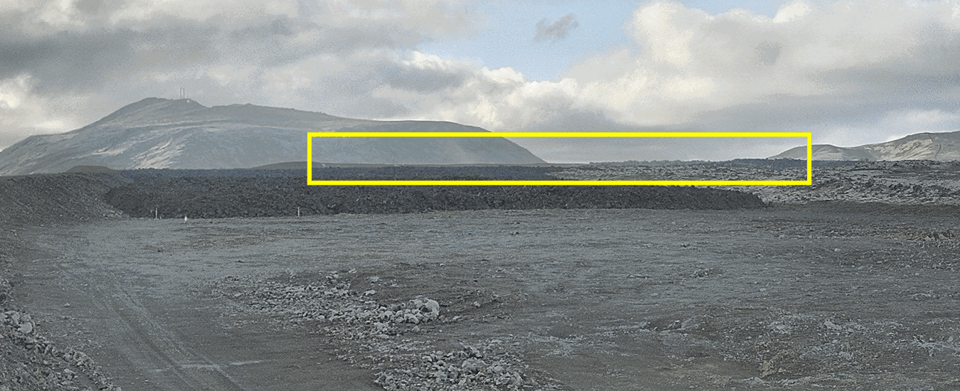
Image
from the camera, owned by the Icelandic Civil Protection, which is located at
the protective barrier East of Grindavík town. The camera is oriented to follow
the lava tongue which propagated towards Suðurstrandavegur at the beginning of
the eruption. The yellow box indicates where the lava field has been thickening
the most over the past few days.
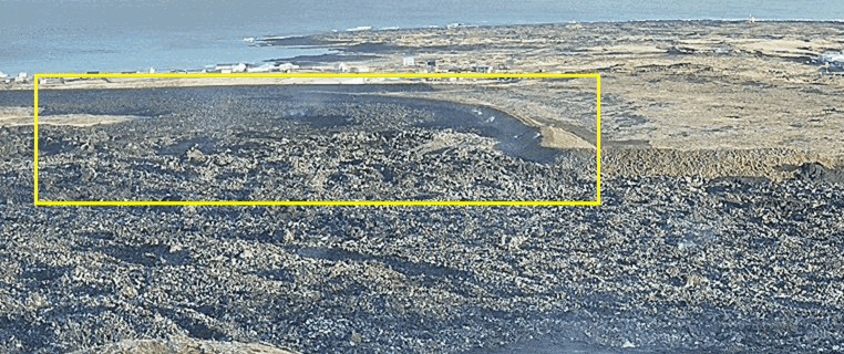
Image from the camera, owned by the Icelandic Civil Protection, which is located on top of Hagafell hill and is oriented towards the south. The yellow box indicates where the lava field close to the potective barrier has been thickening the most over the past few days.
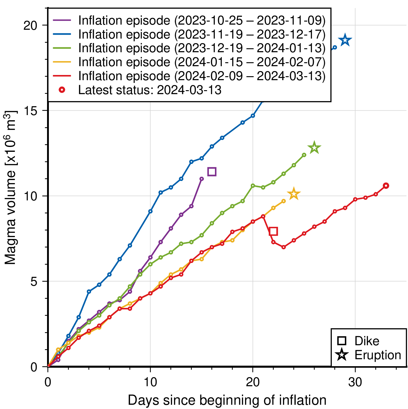
The ground uplift measured around the Svartsengi region continues, indicating that magma accumulates at depth at a stable rate and the total inflow to the reservoir is greater than the outflow feeding the eruption. By using analytical models, constrained by both GNSS and InSAR data, it is assessed that between 7-8 million m3 of magma has been recharged to the Svartsengi reservoir since the eruption commenced on 16 March. In previous events, magma started propagating as dike intrusions from the reservoir at 4-5 km depth towards the surface when a threshold of about 8-13 million m3 of recharged magma was reached.
As long as the magma continues accumulating in the Svartsengi reservoir, the likelihood for a significant escalation in the eruptive activity in Sundhnúk crater row increases.
- New eruptive fissures may open in the area between Stóra-Skógfells and Hagafells and/or the current eruptive vent may enlarge because of a sudden increase in magma flow rate, which might reach levels comparable to those observed at the beginning of the past four eruptions which occurred in the area. If this happens, very short precursors, if any, are expected.
- It is also possible that if more magma starts propagating from the Svartsengi reservoir to the Sundhnúks crater row, this could happen gradually until a balance between the inflow rate at depth and the extrusion rate at the surface is reached.
There is also the possibility that a new dike intrusion will result in the opening of additional eruptive fissures in areas other than between Stóra-Skógfells and Hagafells. This scenario is, however, considered less likely than those previously stated, and if this happens, longer and more intense precursors are expected to occur.
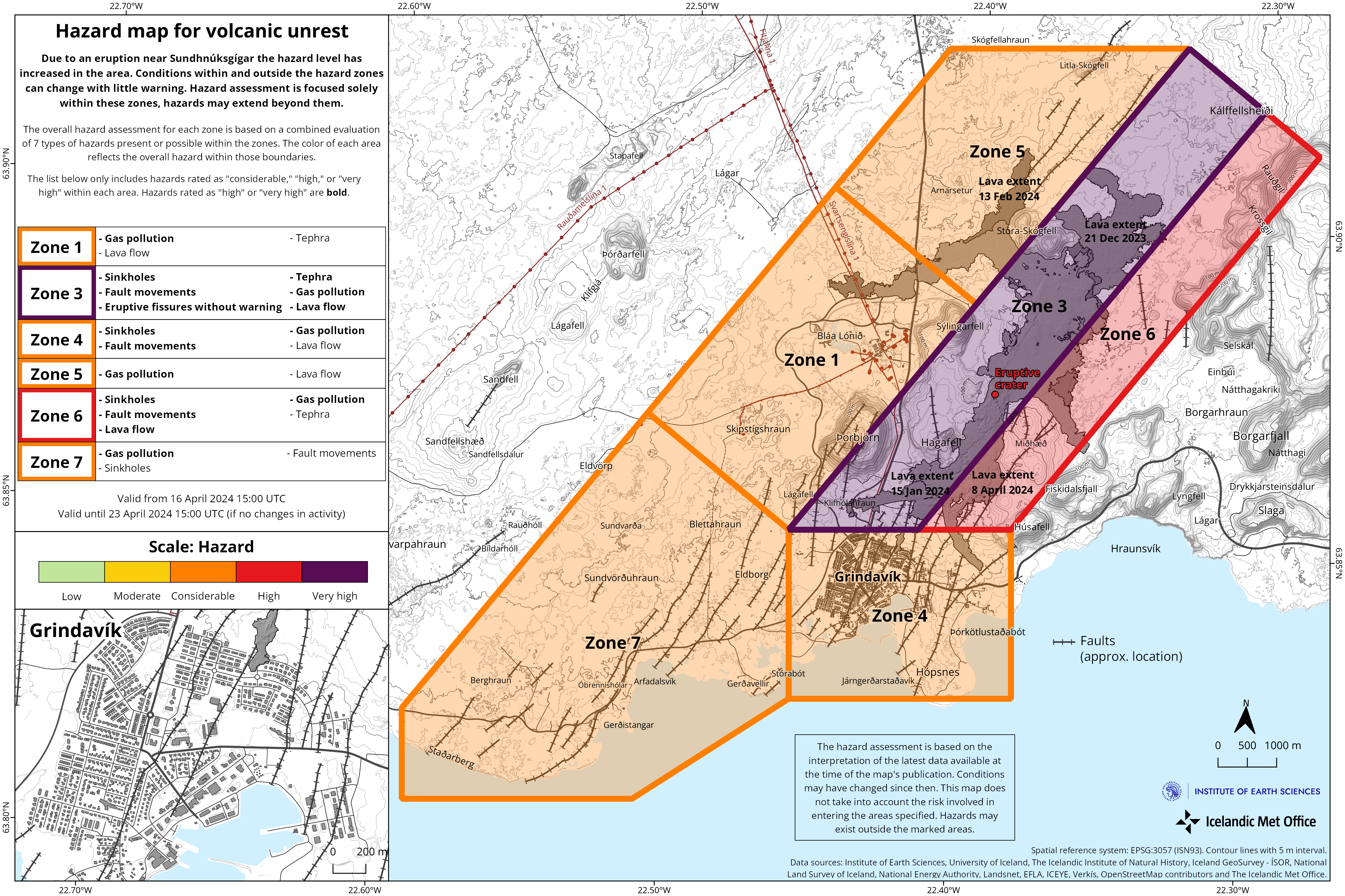
Updated hazard map
During the scientific meeting this morning, the hazard assessment for the ongoing activity was reviewed. The likelihood of opening of eruptive fissures within Zone 1 (Svartsengi), Zone 4 (Grindavík) and Zone 7 has been reduced from being considerable to low.
On Friday last week, due to
the continued inflation of the Svartsengi reservoir, and the high uncertainty
regarding this new situation and possible outcomes, the decision was made to
temporarily increase the likelihood for eruptive openings within these areas.
However, following the meeting today, it has been agreed that there is
currently no evidence for an increased probability of eruptive openings in
these areas.
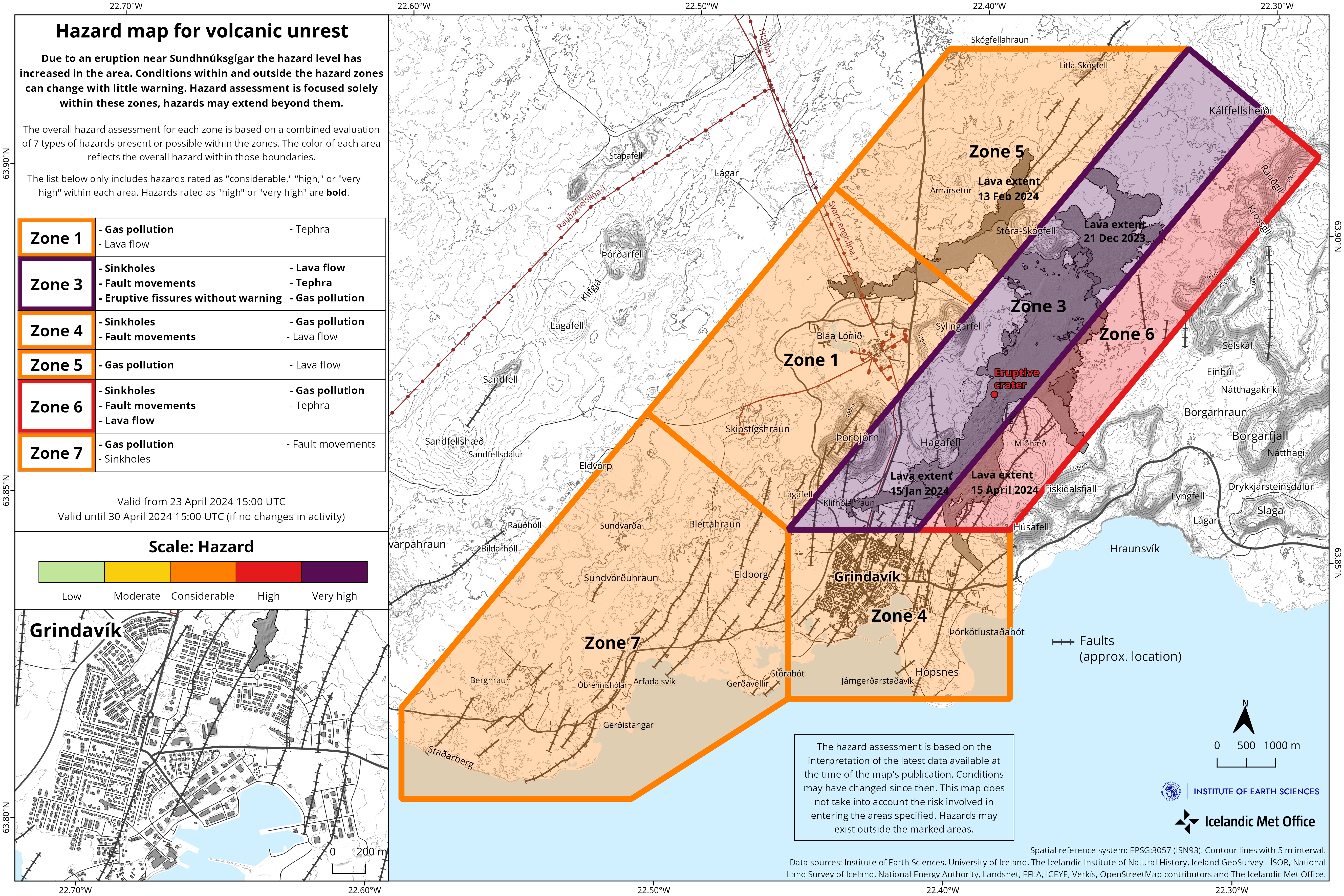
While the eruption continues, it is assessed that if increased magma flow occurs, the magma will most likely follow the open pathways feeding the current eruption and/or new eruptive fissures may form nearby. For this reason, the likelihood of eruptive openings without warning is still assessed to be very high within Zone 3 (Sundhnúks crater row), which remains unchanged.
Updated 19. April at 15:30 UTC
Ground uplift in Svartsengi continues at a steady rate.
Since 5 April, only one crater has erupted and lava flow from it has remained relatively stable since then, just over 3 m3/s.
Continued hazard due to gas emissions. People are advised to monitor air quality.
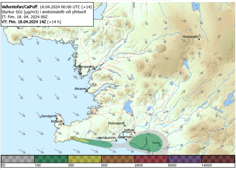
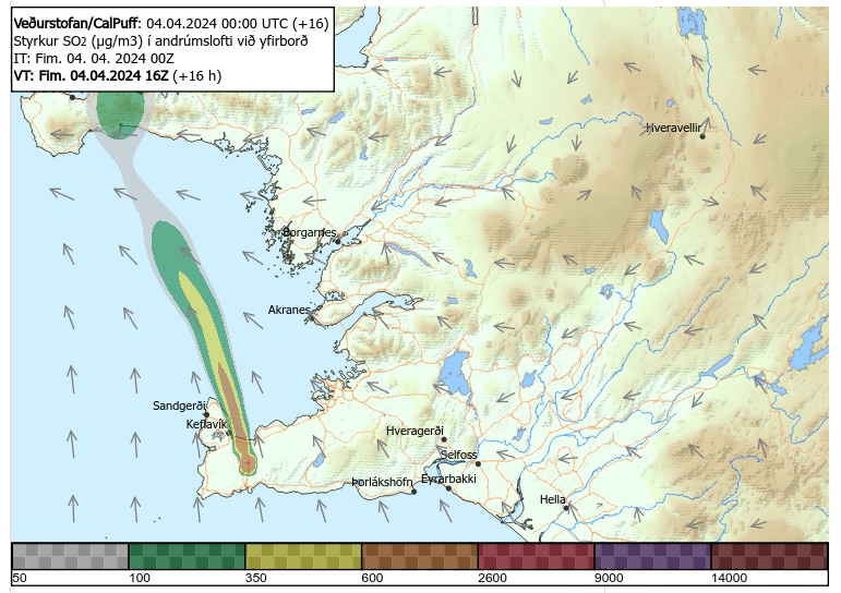
The weather forecast for gas dispersion is here
Continued magma accumulation beneath Svartsengi at current rate increases likelihood of another magma propagation in the coming days or weeks, despite the ongoing eruption.
When the eruption started on the 16 March, ground uplift at Svartsengi slowed down considerably and almost stopped. This indicated an equilibrium between magma inflow into the magma reservoir below Svartsengi, and to the surface at the Sundhnúkur crater row (Figure 1).
At the beginning of April, ground uplift began to increase anew, and a similar volume of magma is now being erupted at Sundhnúkur as is accumulated in the reservoir beneath Svartsengi, causing increased magma pressure (Figure 2).
The current development
is new, which is an ongoing volcanic eruption with a relatively stable lava
flow at Sundhnúkur crater row at the same time as ground is uplifting in
Svartsengi. Therefore, there is more uncertainty now than before about the
possible development of the event.
(Image 2)
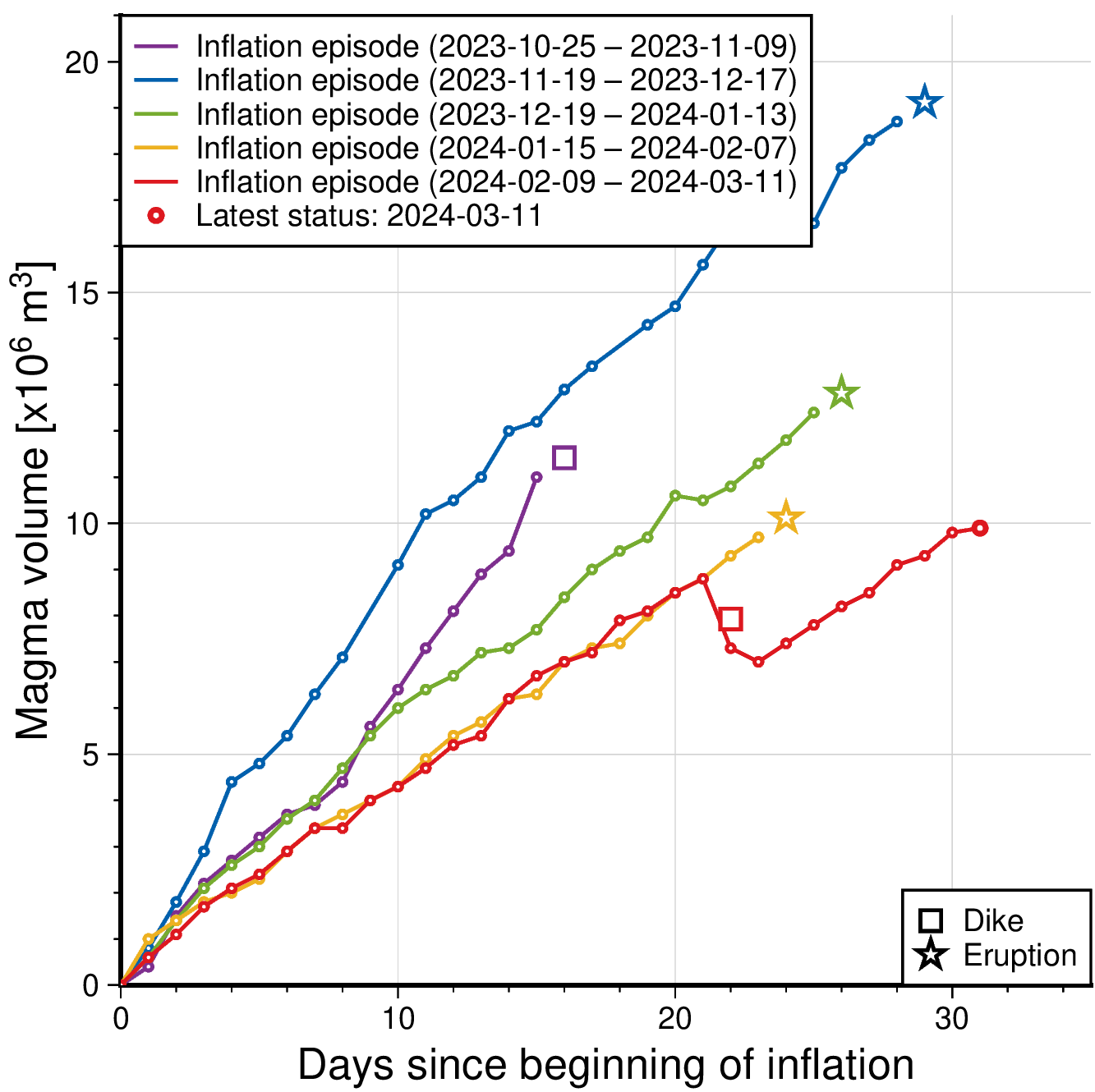
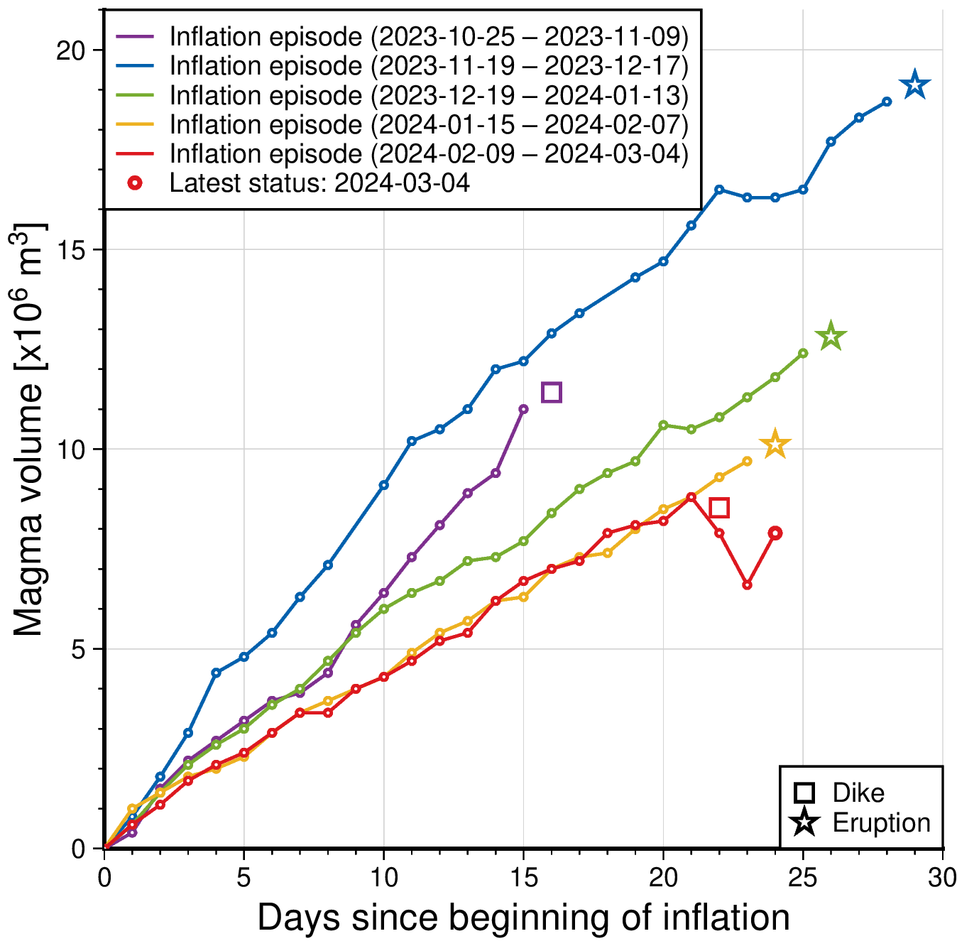
Model calculations indicate that over 6 million m3 of magma has now been added to the magma reservoir beneath Svartsengi since 16 March. In previous events, magma has propagated from Svartsengi when between 8 and 13 million m3 has been added to the reservoir since last event.

The graph shows the estimated
amount of magma that has been added beneath Svartsengi between the volcanic
eruptions and magma propagations that have occurred since November 2023.
More uncertainty concerning the development of the activity in the next days or weeks.
Hitherto, the general trend in Sundhnúkur area has been increased likelihood of magma propagation and even a subsequent eruption. Now however, a new situation seems to be at hand when a magma propagation could occur during an ongoing eruption. Let's recall that magma propagation is a sudden and large flow of magma propagating out of a magma reservoir and can culminate with magma reaching the surface. After the magma propagation on 2 March, which did not end in an eruption, marked a change in the activity that had since December been somewhat cyclical.
If magma accumulation continues at a similar rate, the likelihood of another magma propagation increases in the coming days or weeks, even though an eruption is still ongoing. Magma propagation from the reservoir during an ongoing eruption has thus far not been seen before in the area. Therefore, more uncertainty is on the development of the activity in the next days or weeks.
Probable scenario if magma propagation coincides with the current eruption:
- Magma propagates from the magma reservoir beneath Svartsengi to the Sundhnúkur crater row, as has happened in the last six times.
- Following the magma propagation, new eruptive fissures could open in the area between Stóra-Skógfell and Hagafell and/or the current eruptive crater could be enlarged due to a sudden increase of lava flow. This could occur at very short or no notice.
- If magma propagation results in new volcanic fissures opening up elsewhere above the magma dike which formed on 10 November, much longer notice is expected, most likely intense seismic activity, deformation and pressure changes in boreholes.
- It is also possible that magma propagation will not occur, but that the flow of the current eruption will stop decreasing and begin to increase steadily until a new equilibrium between the inflow of magma from below and flow to the surface from the crater is reached.
- However, if magma propagation results in a new eruptive fissure opening elsewhere than in the area between Stóra-Skógfell and Hagafell, such a scenario would very likely be accompanied by intense seismicity and deformation with considerably more notice than previous eruptions.
Updated hazard assessment
In view of the uncertainty caused by increasing pressure in the magma reservoir beneath Svartsengi, the Icelandic Meteorological Office has increased the hazard due to possible opening of eruptive fissures in Zones 1, 4 and 7 from “low” to “considerable”
However, the overall hazard (color) in the affected Zones does not change.

Updated 18. April at 16:00 UTC
The lava field now covers 6.15km2 and the volume is 33.2 ± 0.8 million m3.
Avegage lava flow from the crater over the period 8-15 April is estimated at 3.2 ± 0.2 m3/s.
Ground uplift in Svartsengi continues at a steady rate.
Continued hazard due to gas pollution. People in the area are advised to check the air quality.
The weather forecast for gas distribution today (Thursday) is northwesterly wind, 3-8 m/s, carrying gas emissions to the southeast. Follow the gas dispersion forecast here.
The eruption at the Sundhnúkur crater row continues and one crater just east of Sundhnúkur remains erupting. The lava field continues to build up nead the craters. The lava also flows in closed channels about 1 km to the southeast and there are active areas in the lava field north of Hagafell.
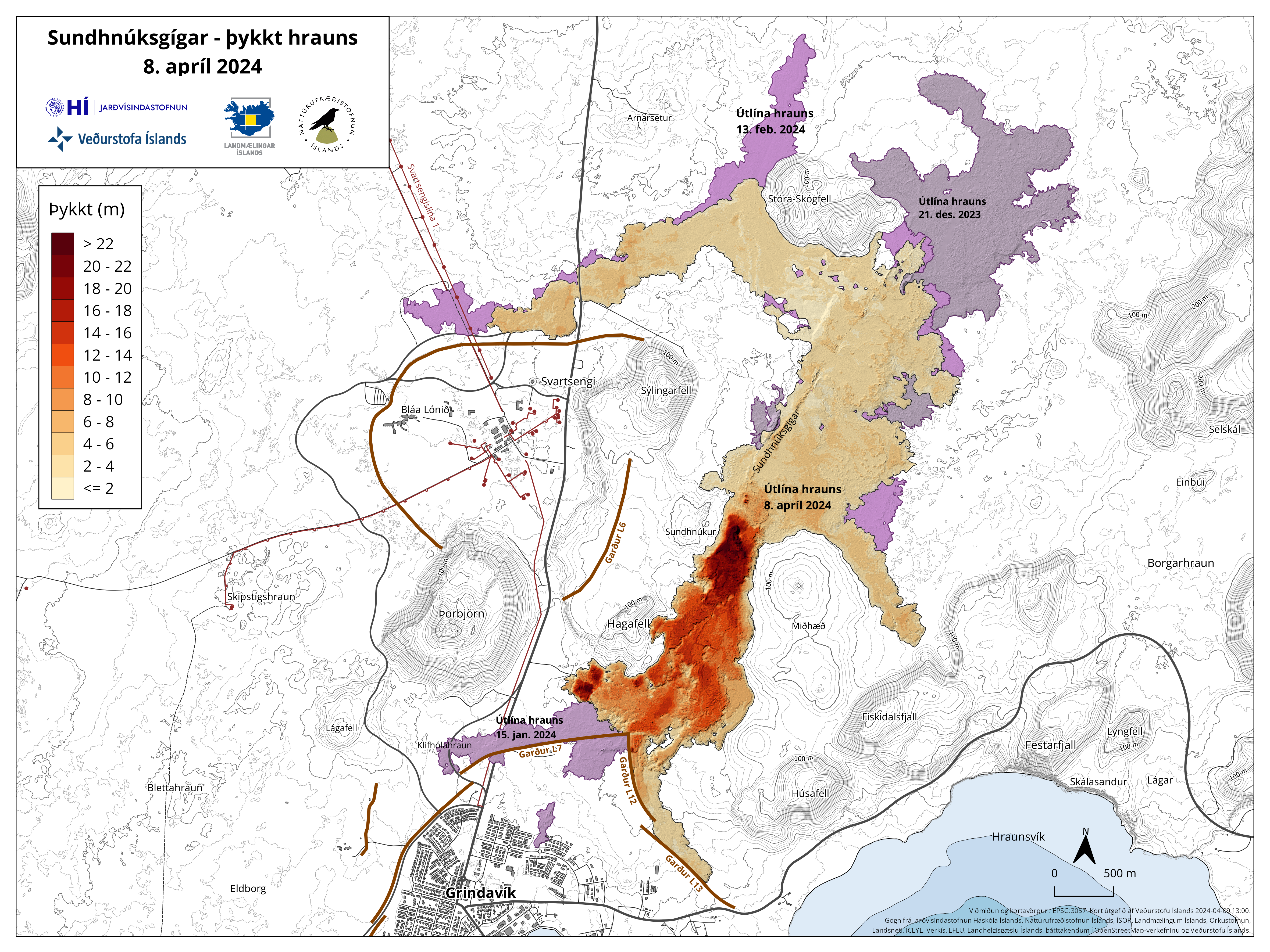
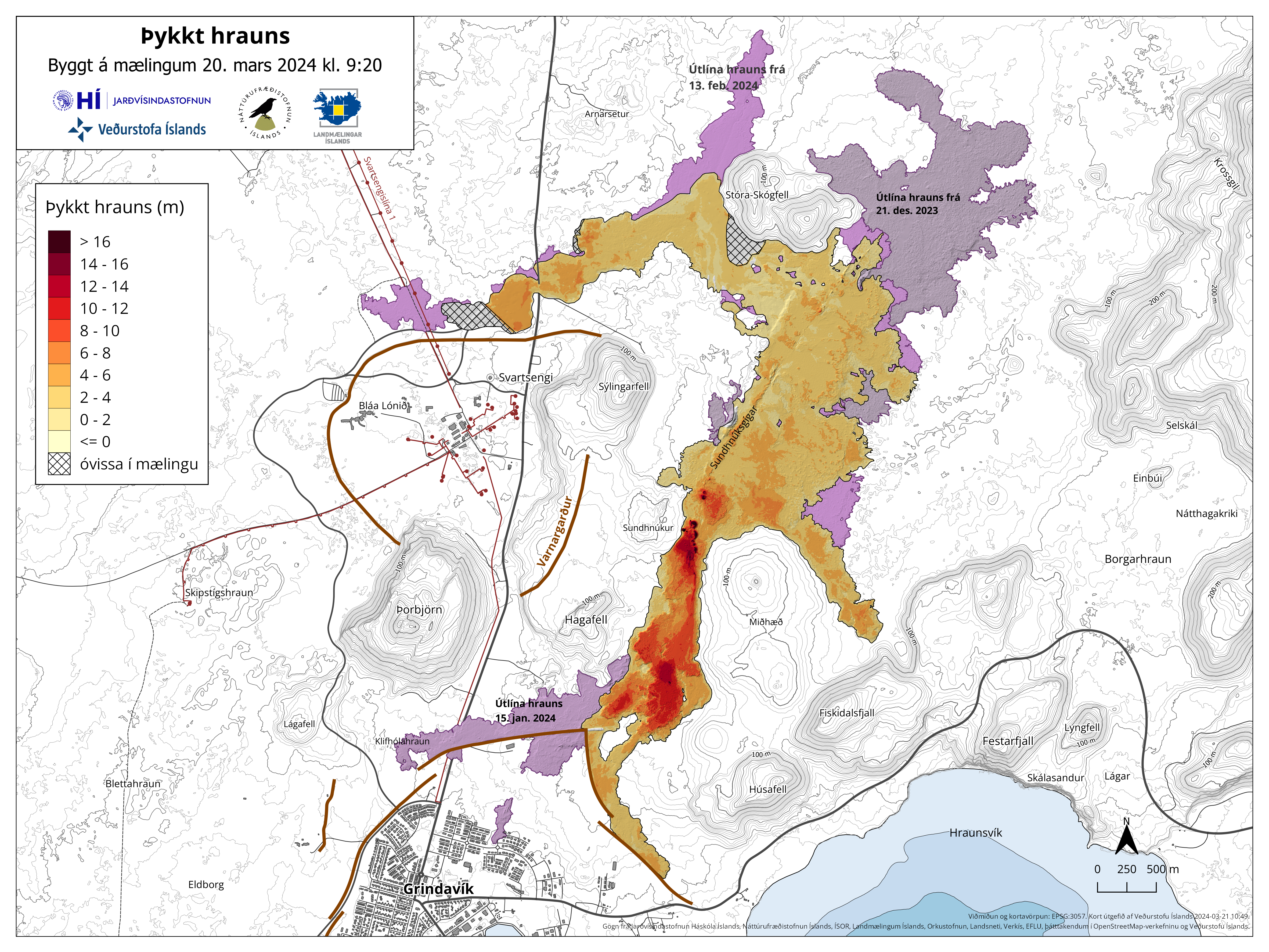
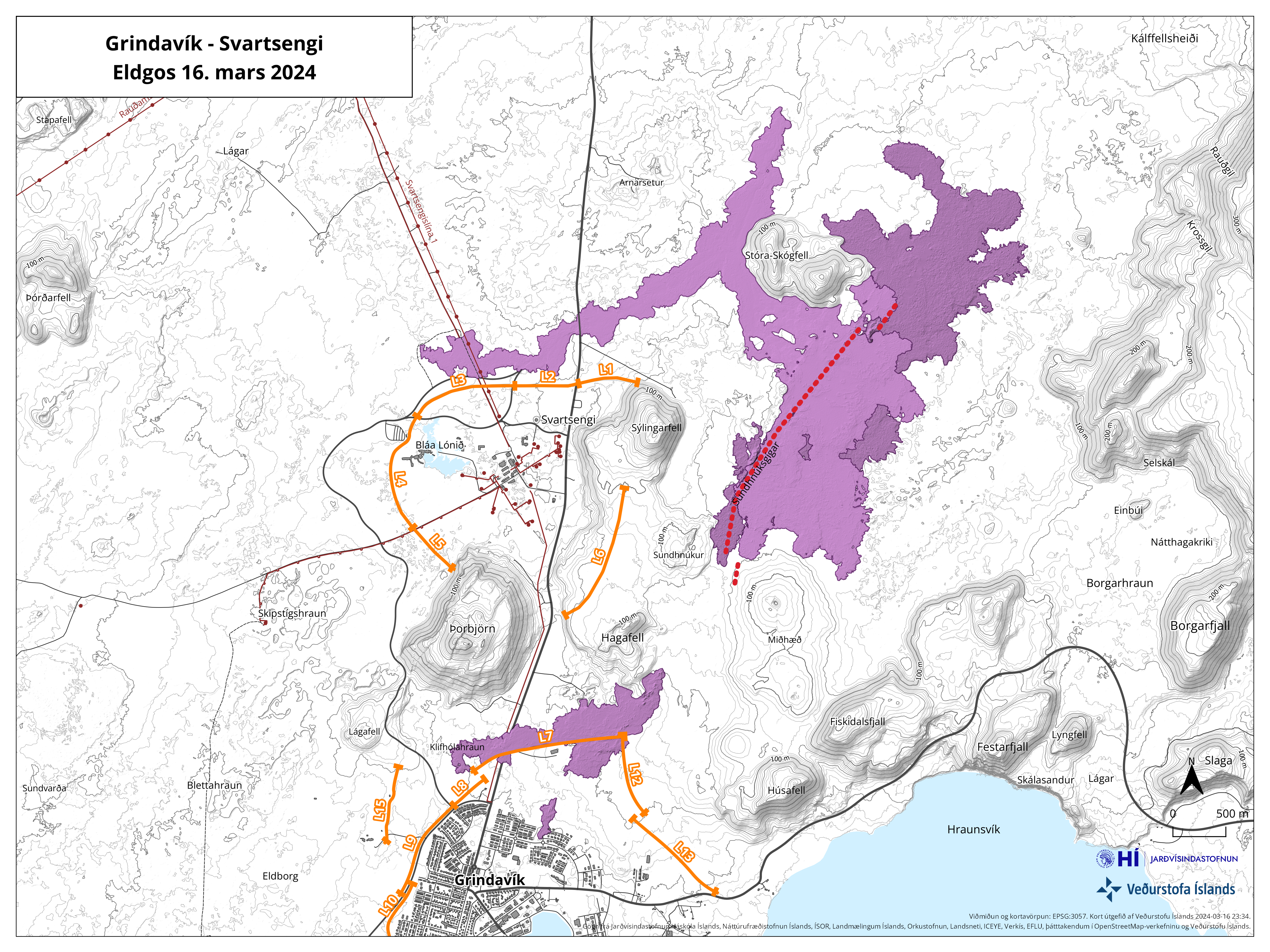
On Monday 15 April, scientists from the Icelandic Institute of Natural History (IINH) and the National Land Survey of Iceland (NLSI) carried out a surrveillance flight over the eruptive area to aquire images for lava mapping by photo-grammetry. The results from the surrveilance flight show that the area of the lava field on the 15 April measured 6.15 km2 and the volume 33.2 ± 0.8 million m3. The lava flow field and the thickness of it is shown on the map below.
Map showing the lava flow area and the thickness of the lava formed in the ongoing eruption. Purple colors show lava formed in the area since December 2023.
The average lava flow from the crater during the period 8-15 April is estimated at 3.2 ± 0.2 m3/s. This is a small change in relation to the average lava flow during the period 3-8 April, which was estimated at 3.6 ± 0.7 m3/s. The result of previous measurement by the IINH and NLSI photogrammetry team can be seen in the table below.
| From | To | Average lava flow during period (m3/s) |
Area (km2) |
Volume (million m3) |
Average thickness of lava field (m) |
| 16. mar.2024 | 17. mar.2024 | 234 ± 9 | 5,72 | 18,1 ± 0,8 | 3,2 ± 0,1 |
| 17. mar.2024 | 20. mar.2024 | 14,5 ± 0,6 | 5,58 | 20,9 ± 0,5 | 3,7 ± 0,1 |
| 20. mar.2024 | 27. mar.2024 | 7,8 ± 0,7 | 5,99 | 25,7 ± 1,9 | 4,3 ± 0,3 |
| 27. mar.2024 | 3. apr.2024 | 6,6 ± 0,3 | 6,13 | 29,7 ± 1,7 | 4,8 ± 0,3 |
| 3. apr.2024 | 8. apr.2024 | 3,6 ± 0,7 | 6,14 | 31,3 ± 2,4 | 5,1 ± 0,4 |
| 8. apr.2024 | 15. apr.2024 | 3,2 ± 0,2 | 6,15 | 33,2 ± 0,8 | 5,4 ± 0,1 |
Ground uplift in Svartsengi continues at a steady rate. This indicates that about half of the magma ascending from depth is accumulating in the magma reservoir, while the other half erupts to the surface at the Sundhnúkur crater row.
Displacements on the GPS station SENG in Svartsengi
since 11 November 2024 to north, east
and vertical (top, middle, bottom). The bottom curve shows ground uplift
in millimeters, and yesterday‘s (17 April) measurement is shown with a green
dot. The red vertical lines are the timing of the last four eruptions (18
December 2023, 14 January, 8 February and 16 March 2024) and the blue lines
show the magma dike intrusions that have occurred in the Sundhnúkur crater row
area without resulting in an eruption (10 November 2023 and 2 March 2024).
There continues to be a hazard due to gas emissions from the eruption, which can cause pollution in settlements in the Reykjanes Peninsula, and we advise people in the area to monitor air quality and familiarise themselves with the response to air pollution from eruptions.
The weather forecast for gas distribution today (Thursday) is northwesterly wind, 3-8 m/s, carrying gas emissions to the southeast. Tomorrow (Friday) winds will be southeast 8-13 m/s with rain. More southerly winds in the evening. Gas pollution will go to the northwest during the day and later to the north. Follow the gas dispersion forecast here.
Updated April 16 at 18:00 UTC
- The hazard assessment has been updated. The overall hazard for Grindavík (Zone 4) is estimated to be considerable (orange).
- Land uplift at Svartsengi continues, and the rate of uplift has been consistent since the beginning of April.
- Continued hazard due to gas pollution. People in the area are advised to check the air quality.
- The gas dispersion forecast can be found here.
- One crater, located east of Sundhnúkur, remains active.
The eruption at Sundhnúkur crater row
continues and has now lasted for one month, as was the subject of a news report
published earlier today. One crater, which is located just east of Sundhnúkur,
continues to erupt. Lava still flows to the south of the crater but does not
extend far, so the lava field continues to build up near the crater. There is
an active lava field near Hagafell, as can be seen in an image from the Icelandic
Meteorological Office‘s webcam located at Þorbjörn.
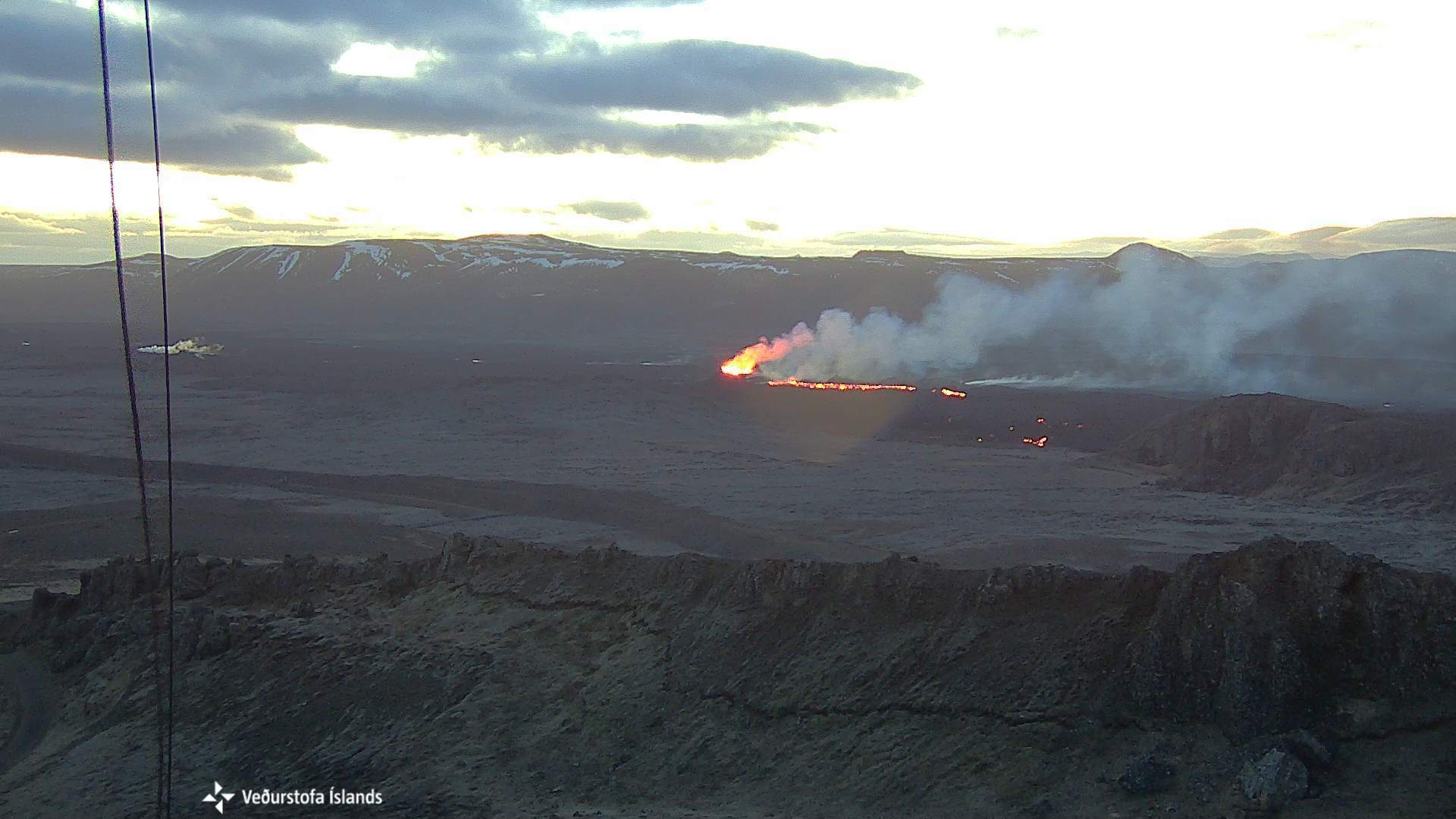
Image from the Icelandic Meteorological Office's webcam, taken at 5:10 AM, 16 April. The webcamera is located on top of Þorbjörn and looks east towards the eruption site. The crater is at the center of the image and lava flows from it. In front of the crater is Sundhnúkur, and on the right side of the image is Hagafell and lava flow fronts.
Seismic activity has been relatively calm near the eruption site since the beginning of the eruption until a small earthquake swarm began at Lágafell after noon on April 14. The seismic swarm lasted over 4 hours and has been associated with stress changes in the crust due to land uplift in Svartsengi. Seismic activity persists in the western slopes of Fagradalsfjall at 6-8 km depth and has been ongoing since the unrest in the Sundhnúkur area during the past 4 months.
Land uplift continues and has been at a steady rate since the beginning
of April. Model calculations based on GPS data indicate that the inflow of magma
into the magma reservoir is about half of what it was prior to the beginning of
the eruption on March 16. This indicates that about half of the magma coming
from depth is accumulating in the magma reservoir, while the other half is
erupted to the surface.
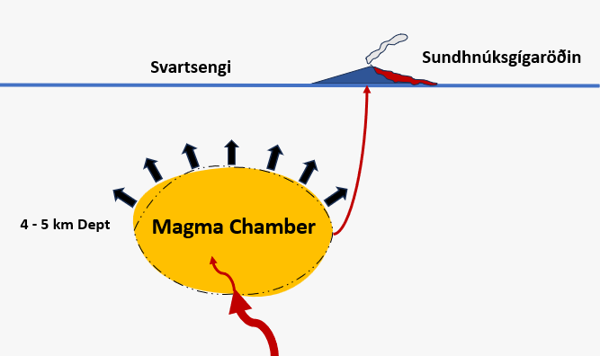
At the beginning of April, the rate of land uplift started to increase. Currently, a similar volume of magma is erupting onto the surface and also accumulating in the magma chamber beneath Svartsengi, causing a pressure increase in the magma chamber.
There continues to be a risk of gas emissions from the eruption, which can cause air pollution in settlements on the Reykjanes Peninsula, and we advise people in the area to monitor air quality and familiarize themselves with symptoms and responses related to air pollution from the eruption.
The weather forecast today (Tuesday) is a slow wind, variable direction. Thus, gas may accumulate near the eruption site. Tonight, winds will be southeasterly 10-15 m/s, carrying gas emissions northwest towards Reykjanesbær. West and northwesterly winds are expected to be 3-10 m/s tomorrow morning, dispersing gas east and southeast towards Þorlákshöfn. Follow the gas dispersion forecast here.
Hazard assessment
The hazards assessment has been updated and is valid from 15:00 today until 23 April barring any developments. The hazards assessment has changed so that the hazard due to lava flows has been lowered in all areas except in Zone 3 (Sundhnúkur crater row) and Zone 6. This change is being made because there has not been an active lava flow in the other areas in the last two weeks. Based on current activity in the eruption, it is estimated that lava is unlikely to flow far from the crater and into other hazard Zones. This change means that the overall hazard in Zone 4 (Grindavík) is now assessed as considerable (orange) instead of high (red). The overall hazard in other areas remains unchanged. The hazard from gas emissions continues to be assessed as high in all areas except at the Sundhnúkur crater row area (Zone 3) where it is assessed to be very high. The hazard in Zone 4 (Grindavík) and Zone 6 continues to be assessed as high due to sinkholes and fault movements.
Updated April 15 at 17:30 UTC
The volcanic eruption that began on March 16 is still ongoing.
Uplift continues at a similar rate since the start of April.
The hazard assessment is valid until April 16, unless the situation changes.
The risk of gas emissions remains significant. People in the area are reminded to monitor air quality.
The gas dispersion forecast can be found here
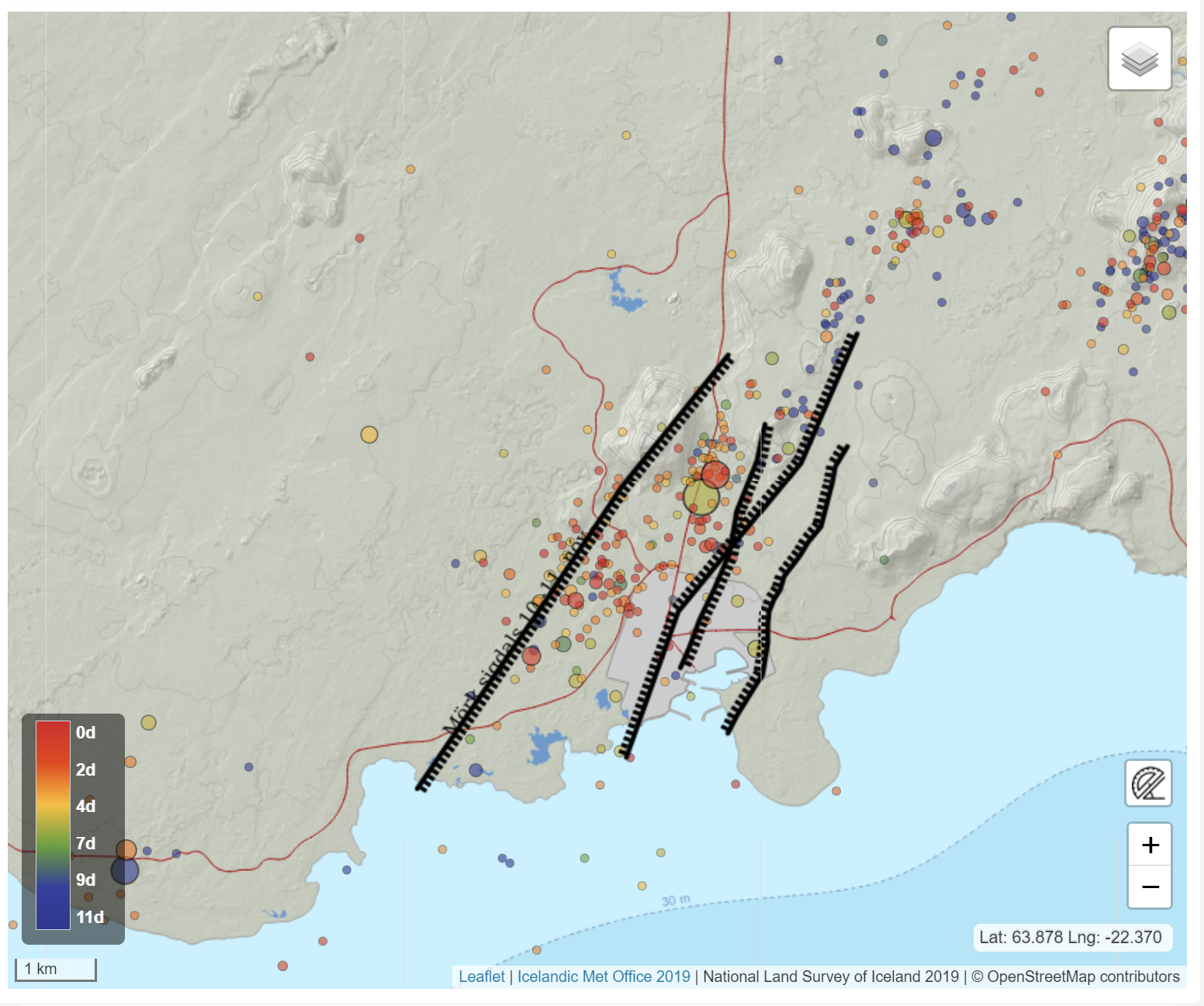
Just after noon yesterday, a small earthquake swarm began near Lágafell, just northwest of Grindavík. It concluded around half past three in the afternoon. The swarm consisted of approximately 90 earthquakes, with the most intense period of activity being 35 earthquakes between 1 and 2 pm. All earthquakes were under magnitude 1, and most were at depths of approximately 2-4 km. This small earthquake swarm likely resulted from stress changes in the Earth's crust due to ongoing land rise in Svartengi, as discussed in yesterday's news update.
Attached is a figure showing the location of the earthquakes on a map, and below that is a graph showing their depth. The panel in the top right displays earthquake magnitudes in the region from noon until evening yesterday. The panel in the middle right shows the cumulative number of earthquakes, while the bottom panel displays the number of earthquakes per hour. As the graph shows, several small earthquakes were recorded in the area yesterday afternoon, but there hasn't been any seismic activity in the region since midnight today.
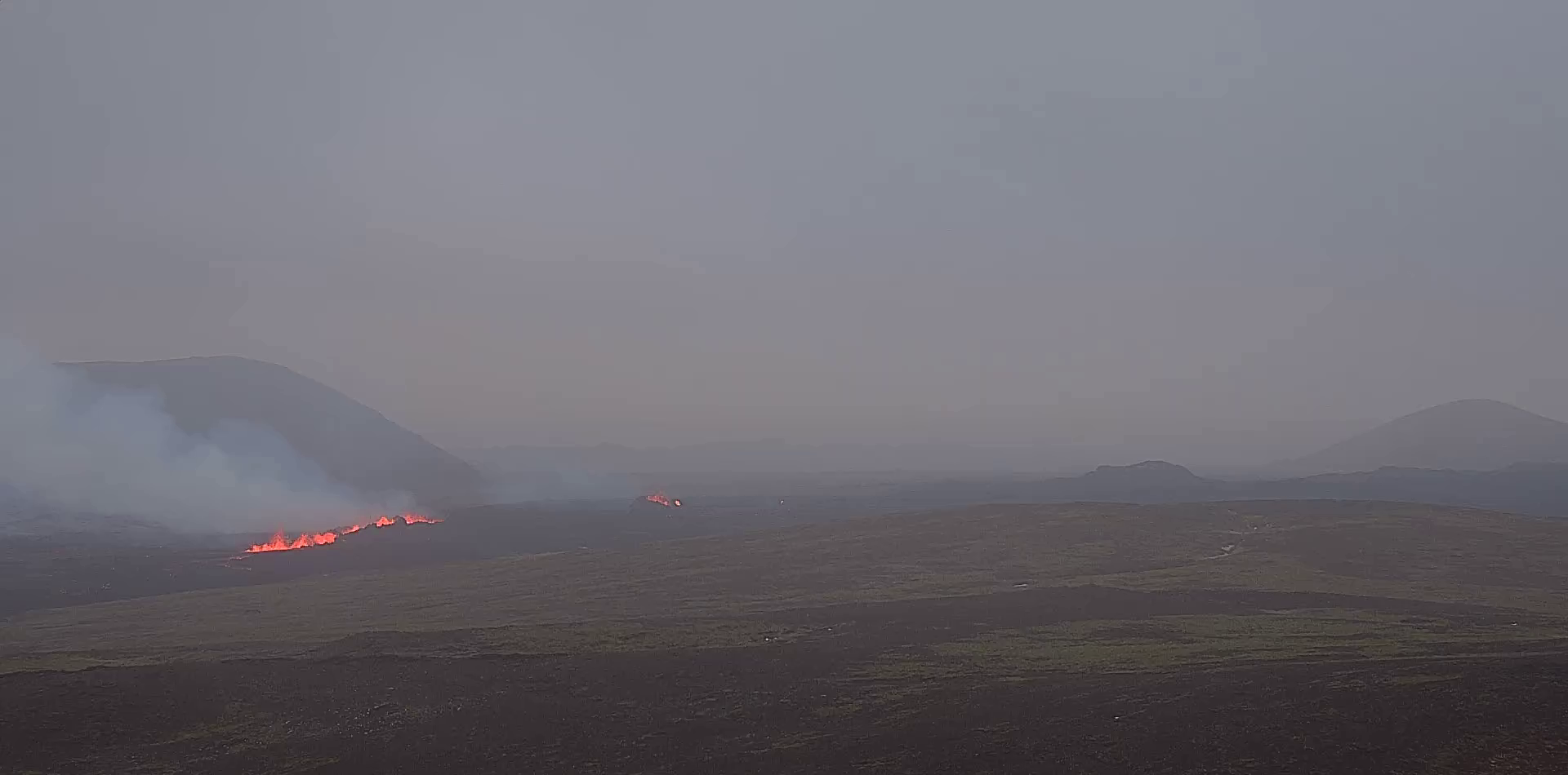
Photograph taken on Wednesday, April 10, showing the
active vent as seen from Sundhnúkur. (Photograph: Jón Bjarni
Friðriksson/Icelandic Meteorological Office). Click on the image to see it larger.
Updated April 14 at 18:00 UTC
The volcanic eruption that began on March 16 is still ongoing.
Uplift continues at a similar rate since the start of April.
The hazard assessment is valid until April 16, unless the situation changes.
The risk of gas emissions remains significant. People in the area are reminded to monitor air quality.
The gas dispersion forecast can be found here.
Several small earthquakes (below magnitude 1) have been detected northwest of Grindavík in the last few hours. (See figures below.) This seismic activity is focused near the dike that formed on November 10 and is likely related to the ground deformation in Svartsengi, which affects the region's pressure regime.
Today's seismic activity is comparable to the activity measured in this area in mid-March last year. Therefore, the seismic activity does not indicate any changes in the ongoing volcanic eruption, which has remained relatively stable over the weekend. The seismic activity northwest of Grindavík is also not indicative of magma moving beneath that area.
At the time of writing, the seismic activity northwest of Grindavík has slightly decreased. It is unlikely that large earthquakes will accompany this current activity.
Should magma deviate from its current route that surfaces at the Sundhnúkur crater row, opting instead for an alternate path, such as heading west towards Eldvörp or south of Þorbirnir, the precursor to a possible eruption in that area would involve very intense seismic activity and ground deformation that is clearly visible on instruments and satellite imagery. Currently, there are no such signs at this time.
The Icelandic Meteorological Office continues its 24-hour surveillance of the area to monitor the eruption site.
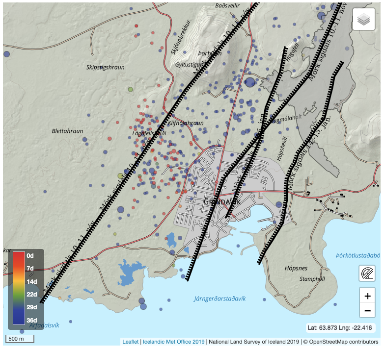
This figure displays seismic activity from March 9 until today, April 14. The black lines represent the outer boundaries of the grabens formed in connection with the significant dike intrusion on November 10, 2023, and the eruption on January 14 of this year. Most of the earthquakes today have been smaller than magnitude 1. Blue circles represent earthquakes that occurred from March 9 to 14, while red circles represent earthquakes that occurred today, April 14. The earthquakes are located on the western edge of the depression formed on November 10.
In the area northwest of Grindavík, there is a series of known faults with a north-south orientation that formed when the dike intrusion occurred on November 10. Therefore, today's earthquakes are also indicative of stress release along these faults due to the land uplift in Svartsengi.
Updated April 12 at 14:15 UTC
- The volcanic eruption that began on March 16 is still ongoing.
- Land rise continues at a similar rate since the start of April.
- The hazard assessment is valid until April 16, unless the situation changes.
- The risk of gas emissions remains significant. People in the area are reminded to monitor air quality.
- The gas dispersion forecast can be found here .
The eruption that started at the Sundhnúkur crater row on the evening of March 16 is still ongoing. One vent remains active, as it has been since April 5. Lava continues to flow southward from the vent but does not travel far, so the lava field continues to build up near the crater. There are no apparent signs of lava advancing towards the protective barriers north of Grindavík, Suðurstrandarvegur, or Melhólsnáma.
Land rise in Svartsengi continues at a similar rate, which increased at the beginning of April. This is a faster rate than that observed from the start of the eruption on March 16 until the end of March. This indicates that the majority of the magma flowing into the reservoir beneath Svartsengi is accumulating there, causing an increase in pressure and ground uplift. While the eruption continues, there remains an open connection between the magma accumulation area in Svartsengi and the Sundhnúkur crater row, and a portion of the magma continues to flow to the surface there. Minor changes in the lava field can be observed between days, but the overall rate has been steady since the beginning of April.
The hazard assessment remains unchanged and valid until 15:00 on April 16. See more details here.
There is still a risk of gas emissions from the volcano, which could cause pollution on the Reykjanes Peninsula. People in the area are advised to monitor air quality and familiarize themselves with symptoms of exposure to volcanic gas pollution.

A photograph taken on Wednesday, April 10th, showing the active crater as seen from Sundhnúkur. (Photo: Jón Bjarni Friðriksson)
Updated 9. April at 17:30 UTC
Despite a decrease in the intensity of the volcanic eruption, there are no signs that the overall magma flow from the depth is decreasing.
The average flow rate of the lava flow from the vents between April 3rd and 8th is estimated to be 3.6 ± 0.7 m3/s.
Tomorrow, easterly and southeasterly winds are expected, carrying gas emissions westward and northwestward from the eruption sites. Follow the gas dispersion forecast here.
Periodically high levels of SO2 continue to be measured around the volcano and in settlements on the Reykjanes Peninsula. Residents are advised to monitor air quality in the area.
Experts from the Icelandic Meteorological Office and the National Land Survey conducted aerial measurements over the eruption site yesterday, April 8th. Using the data collected during the flight, it is possible to assess the size of the lava field and the flow rate of lava from the eruption. The results indicate a steady and substantial decrease in the intensity of the volcanic eruption.
The average lava flow from the vents between April 3rd and 8th is estimated to be 3.6 ± 0.7 m3/s. Based on data collected by the engineering firm Efla on April 3rd during a drone flight, the average lava flow was estimated to be 6.6 ± 0.3 m3/s from March 27th to April 3rd. The lava field has reached an area of 6.14 km2 with a volume of 31.3 million m3. Previously, the lava primarily flowed south from the vents, but briefly shifted northward on Sunday evening (April 7th) when a vent wall collapsed, as mentioned in the last update. As shown on the accompanying map, the lava has thickened significantly near the vents and just south of them, where the most activity is in the lava field. There are no apparent signs of lava advancement toward protective barriers north of Grindavík, Suðurstrandarvegur, or Melhólsnáma.
Map showing the
extent and thickness of the lava formed in the current eruption. Purple areas
show lava that has flowed in the area since December 2023.
Ground deformation has increased over the past week
Ground deformation in Svartsengi continues to increase, coinciding with a decrease in the intensity of the volcanic eruption. This indicates that the majority of the magma flowing into the reservoir beneath Svartsengi is accumulating there, causing an increase in pressure and ground uplift. While the eruption continues, there remains an open connection between the magma accumulation area in Svartsengi and the Sundhnúkur crater row, and a portion of the magma continues to flow to the surface there.
Seismic activity in the dike near Grindavík has remained very low and is focused between Sýlingarfell and Stóra-Skógafell, with slight seismicity in western Grindavík. Seismic activity near Fagradalsfjall, which has been persistent for the past month, is ongoing and remains localized at depths of about 6-7 km.
Gas measurements conducted yesterday, April 8th, estimate a sulfur dioxide (SO2) emission rate of 10-18 kg/s from the vents. Periodically high levels of SO2 continue to be measured around the volcano and in settlements on the Reykjanes Peninsula. Gas emissions from the eruption will likely cause pollution on the Reykjanes Peninsula, and residents are advised to monitor air quality and familiarize themselves with symptoms related to air pollution from the eruption.
According to the weather forecast, northerly winds are expected today, carrying gas emissions southward. Slow variable winds in the afternoon may result in gas pollution near the eruption sites. Easterly and southeasterly winds are expected tomorrow, carrying gas emissions westward and northwestward. Follow the gas dispersion forecast here.
Unchanged risk assessment
The hazard assessment has been updated and is valid from 15:00 today until April 16th, unless the situation changes. There are no changes in the hazard assessment, and the risk of gas pollution remains high in all areas except around the Sundhnúkur crater row (Zone 3), where it is assessed to be very high. The risk in Zone 4 (Grindavík) and Zone 6 remains high due to earthquakes, ground deformation, lava flows, and gas pollution.

(Click on the image to see it larger)
Despite the decrease in the intensity of the volcanic eruption, there are no signs that the overall magma flow from depth into the Svartsengi reservoir is decreasing. This refers to the total volume of magma accumulating under Svartsengi, in addition to the magma flowing towards the surface in the current eruption at the Sundhnúkur crater row. It is difficult to predict when this eruption will end; it could continue for a longer period with steady flow or cease in the near future. As magma continues to accumulate under Svartsengi and pressure rises, a possibility remains that the eruption's intensity may increase again, similar to the events at Fagradalsfjall in 2021. If the eruption ceases soon, magma accumulation will likely continue under Svartsengi, and a sequence of events similar to that observed in the past month may repeat.
Updated 8. April at 16:30 UTC
- The volcanic eruption continues. One vent is active.
- The land has risen in Svartsengi approximately 2-3 cm between April 2nd and 7th.
- Minimal gas emissions were measured over the weekend, but periodically high levels of sulfur dioxide can still be detected around the volcano and in settlements on the Reykjanes Peninsula. Residents are advised to monitor air quality in the area.
- Today's weather forecast indicates a northeasterly wind direction, causing gas emissions to drift southwestward over areas including Grindavík. Easterly winds are expected tomorrow, April 9th, and gas emissions are anticipated to travel west from the eruption sites. Follow the gas dispersion forecast here.
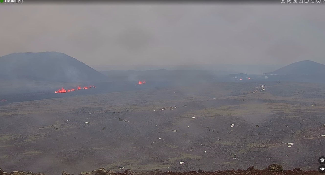
The eruption at the Sundhnúkur crater row continues, with one vent now active. Yesterday, lava from the vent flowed southward in a constrained stream, resulting in a magnificent river of lava. Meanwhile, the surface level of lava in the crater gradually increased until it was nearly filled. The northern wall of the vent collapsed around 21:30 yesterday evening, causing the lava to flow northward. Today, April 8th, the lava flow has mostly resumed its southward direction. The lava advancing towards the north, as observed yesterday evening and overnight, appears to have halted on the hillside. The crater continues to fill up.
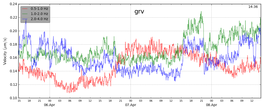
Seismic measurements near the eruption site show volcanic tremor that exhibits strong frequencies between 1 and 2 Hz (green curve on the graph); an increase in the strength of this tremor corresponds with the peak flow of lava from the vent. After the collapse of the vent wall, seismic activity appears to decrease again. Similar seismic activity was observed during the recent Geldingadalur volcanic eruption, during which seismic activity increased as the output of lava intensified.
Uplift has slightly increased in Svartsengi, and based on GPS measurements and synthetic aperture radar images, the land has risen by 2-3 cm from April 2nd to 7th. However, this is less than the ground deformation measured after the previous eruption last month. Increased uplift could indicate that magma flowing into Svartsengi has increased or that there has been a slowdown in the flow of magma towards the current eruption site.
Minimal gas emissions have been detected on gas monitors operated by the Environment Agency of Iceland (UST) and the Icelandic Meteorological Office over the weekend, but periodically high levels of sulfur dioxide can still be detected around the volcano and in settlements on the Reykjanes Peninsula. Residents are reminded to monitor air quality on the UST air quality website loftgæði.is
Today's weather forecast indicates a northeasterly wind direction, causing gas emissions to drift southwestward over areas including Grindavík. Easterly winds are expected tomorrow, April 9th, so gas emissions can be anticipated to drift west from the eruption sites. The latest gas dispersion forecast can be followed here.
Updated 4. April at 17:00 UTC
The
eruption at the Sundhnúkur crater row continues and two craters are still
active as in recent days. The northern crater is larger and most of the lava
flow seems to be erupted from it, as can be seen in the image below which was
taken last night, 3 April. Lava continues to flow south from the craters on top
of the lava field formed in the first few days of this eruption. Last night
there no clear signs of lava flow progressing alongside the lava barriers north
of Grindavík, Southcoast road or Melhólsnáma mine.

Aerial image from a drone flight operated by Civil Protection last night, 3 April. The image shows the two craters and the lava flowing from them towards the south.
An
interferogram covering the period 18 March - 3 April shows that land has risen
about 3 cm in Svartsengi during that time. This is considerably slower
deformation that was measured prior to the eruptions and dike propagations
which have occurred in last months. Data from GPS measurements during the same
period suggests that the rate of the land uplift has varied, but it difficult
to estimate day-to-day deformation based on this data. Considering the GPS data
for the same time period as the interferogram (18March – 3 April), the two
datasets are consistent. Land uplift is detected in Svartsengi during the
eruption, which has not been seen in the events that have occurred previously
on the Sundhnúkur crater row. This
indicates that the system is open, and magma continues to flow from
considerable depth below Svartsengi to the surface in the Sundhnúkur crater
row.
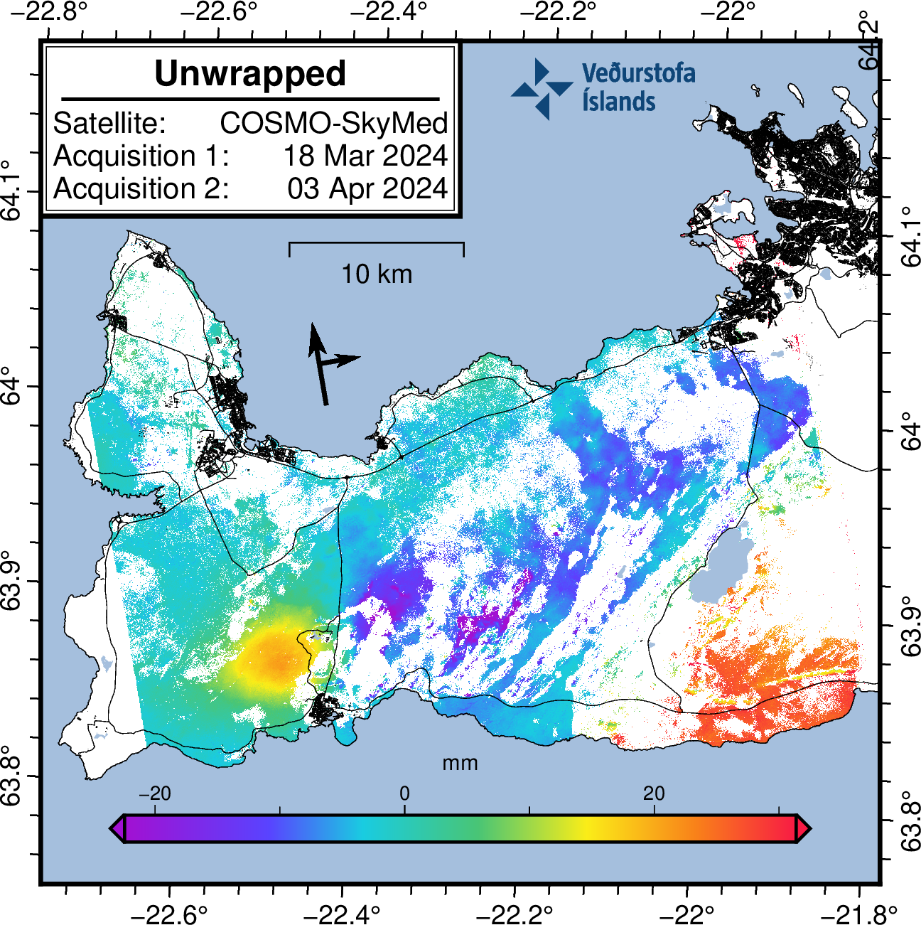
Interferogram (InSAR) showing deformation from 18 March – 3 April. Yellow and orange colors show areas around Svartsengi where land uplift is detected.
Gas measurements carried out last Tuesday, 2 April, estimate that approx. 37-41 kg/s of SO2 is emitted from the craters. Temporary high sulfur dioxide levels continue to be measured around the eruption site and in municipalities in the Reykjanes peninsula. Gas from the eruption is likely to cause pollution in the Reykjanes peninsula and we advise people in the area to monitor air quality at loftgaedi.is and familiarize themselves with the response to air pollution from volcanic eruptions.
The weather forecast today (Thursday) is southeast and southerly winds of 8-13 m/s at the eruption site, causing gas to be dispersed to the northwest and north, meaning gas could be detected in Vogar, Reykjanesbær and Suðurnesjabær. Easterly winds 5-10 m/s tomorrow (Friday), causing gas dispersion towards the west, for example to Svartsengi. Northesterly winds, 5-10 m/s late tomorrow causing gas pollution in the southwest and possibly in Grindavík.
Gas
distribution forecast is here.
Hazard assessment published on 2 April remains unchanged and is valid until 9 April barring any developments.
Updated 2. April at 17:30 UTC
The eruption continues and two craters are now active. Inflation hasn‘t been detected in the last few days.
Lately, vegetation fires have started around the lava field, and is an ongoing risk while the weather is dry.
Gas pollution is dispersed to the southwest and later to the west and is likely to be detected occasionally in Grindavík and possibly in Hafnir. Gas distribution forecast and air quality can be monitored.
Lava margins have reached considerable heights and can be unstable.
Hazard assessment unchanged.
The eruption at the Sundhnúkur crater row continues and two craters are now active. The third crater, which was much smaller than the other two, was extinguished at Easter. Volcanic tremor remains stable.
Inflation in Svartsengi has not been detected in recent days, indicating that less magma accumulates in the magma reservoir beneath Svartsengi, and flows instead towards the craters where it erupts. A balance may be reached between the influx of magma into the Svartsengi reservoir and the eruptive craters, but geochemical surveys might confirm this in the future.
Experts from the National Land Survey of Iceland have processed satellite data from 27 March showing that the lava field was then 5.99 km2 and the volume of lava since the beginning of the eruption was 25.7 ± 1.9 million m3. The average extrusive rate of lava from the craters was estimated at 7.8 ± 0.7 m3/s, which is very comparable to the extrusion rate during the first phase of the Geldingadalir eruption in 2021. The aim is to take aerial photographs of the area in the coming days to get updated extrusion rates since 27 March, which will give further insights into the development of the eruptive activity. The following map shows the lava flow field and its thickness as it was on 27 March.
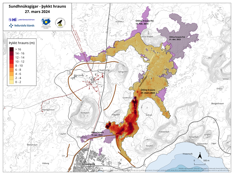
Map showing the flow field and thickness of the lava formed during the ongoing eruption. Purple layers show lavas that have formed in the area since December 2023.
Vegetation fires around the lava field
Lately, vegetation fires have started around the lava field, and is an ongoing risk while the weather is dry.
Lava margins have reached considerable heights and can be unstable, sudden and rapid lava outbursts can occur if new lobes of lava break out from the edge of a lava margin.
In recent days, high levels of hydrogen sulfide have occasionally been detected in Grindavík. The weather forecast today (Tuesday) is northeasterly and later easterly winds 5-13 m/s at the eruption site. Gas pollution is therefore dispersed to the southwest and later to the west, and is likely to be detected occasionally in Grindavík and possibly in Hafnir. Easterly and southeasterly winds 3-10 m/s tomorrow (Wednesday) causing gas pollution to travel to the west and northwest, and thus could be detected in many parts of the western Reykjanes area, including Reykjanesbær. Gas distribution forecast is here.
Hazard assessment unchanged
The hazard assessment has been updated and is valid from 15:00 today until 9 April, barring any significant developments. There are no changes to the hazard assessment and the hazard from gas pollution continues to be assessed high in all areas except at the Sundhnúkur crater row area (zone 3) where it is assessed as very high. The hazard in zone 4 (Grindavík) and zone 6 continues to be assessed as high due to sinkholes, fault movements, lava flow and gas pollution.

Updated 27. March at 14:00 UTC
- High levels of SO2 (Sulfur Dioxide) were measured over the weekend. Gas dispersion forecast can be followed here .
- This concentration of SO2 is considered very unhealthy. It is important to pay close attention to developments in air quality.
- The volcanic eruption has been stable since Monday, 25. March.
The volcanic eruption has
been stable since Monday, 25 March. Eruption tremor has remained consistent
since then, as has the activity in the three craters. Lava continues to flow
southward from the craters mostly atop the lava field formed during the first
days of the eruption. The following image shows the extension of the lava field
as extrapolated from satellite images (ICEYE). The latest acquisition was on 26
March and it shows the widening of lava field towards the west, south of
Hagafell, as well as further lava advancement towards the east and the south of
the active vents.
Striped areas indicate regions where changes occurred in the lava field between March 20 and 26. The red-striped part of the area signifies area where lava had not flowed previously in this eruption. Light purple areas denote areas where lava flowed from eruptions in February and January.
Uplift continues in Svartsengi but at a slower rate than prior to previous eruptions or dike intrusions in recent months. This suggests that magma is still accumulating beneath Svartsengi despite ongoing eruption. Little to no seismic activity has been detected in the area.
High levels of SO2 measured past few days
Since friday (22 mars) two additional stations to monitor the concentrations of SO2 at the ground have been installed. VÍ, in collaboration with Almannavarnir, located them at Blue Lagoon and in the harbour area in Grindavík. Both stations are streaming data to the UST website, loftgæði.is.
Early yesterday morning, at around 03:00, the station in BL revealed levels of SO2 up to 7000 microgram/m3, and this morning at around 04:00 the station in Grindavík (Nesvegur) measured concentrations up to 9000 micrograms/m3. Such concentrations are considered óholl and people are recommended to follow the instructions provided by UST and Embætti landlæknis (link). On the 26th March, the station in Hafnir also showed high concentrations of SO2 up to about 2000 microgarm/m3 around midday. The amount of SO2 released by the eruption and the meteorology in the area are still creating the conditions for severe gas pollution in the peninsula.
Updated 25. March at 16:30 UTC
- High levels of SO2 (Sulfur Dioxide) were measured over the weekend. Gas dispersion forecast can be followed here .
- This concentration of SO2 is considered very unhealthy. It is important to pay close attention to developments in air quality.
- Volcanic activity appears to have decreased at Sundhnúksgíga.
- The hazard assessment remains unchanged. Increased hazards persist due to gas emissions
Volcanic activity at Sundhnúksgíga appears to have decreased over the past few days. Activity in the vents has decreased and possibly ceased in the smallest craters. Additionally, volcanic tremor has gradually diminished over the past few days. The main lava flow runs southward from the vents and then bends westward. Over the weekend, lava continued to flow into Melhólsnáma and has now filled it. However, the lava also continues to thicken near the craters.
GPS measurements in recent days indicate ongoing land rise in Svartsengi, but it exhibits a slower rate than before. This suggests that magma continues to accumulate in the reservoir beneath Svartsengi despite the ongoing eruption.
High levels of SO2 measured past few days
High levels of SO2 have been measured in Höfn and Grindavík the past few days. This concentration is considered very unhealthy, and people are likely to experience respiratory symptoms if exposed. It is important to stay indoors, close windows, and turn off air conditioning. This is especially important where outdoor work is being carried out, as stated by the work safety authorities; companies and institutions in the southwest region of the country must pay close attention to further developments in air quality due to the potential risk of gas pollution. People in the area are advised to monitor air quality and familiarize themselves with symptoms of air pollution from volcanic gases.
The weather forecast for today (Monday) predicts northeasterly winds of 3-8 m/s at the eruption sites, with the pollution drifting southwestward (over Grindavík and Svartsengi); gas may accumulate near the eruption sites due to slow wind speeds. In the evening, night, and early morning hours, winds are expected to come from the east at 8-13 m/s at the eruption sites, causing pollution to drift westward, towards areas including Hafnir. During this period, it's also possible that the wind may become southeasterly at times, potentially causing pollution in Njarðvík, Keflavík, and Sandgerði. By late afternoon tomorrow (Tuesday), winds will shift to be northeasterly at 3-8 m/s, causing the gas pollution to drift southwestward (over Grindavík and Svartsengi) and possibly to accumulate near the eruption sites due to light winds. The gas dispersion forecast can be found here.
No changes in the hazard assessment
The hazard assessment has been updated and is valid from 15:00 today until April 2, barring any significant developments. There are no changes in the hazard assessment, and the risk of gas pollution remains high in all areas except for the Sundhnúksgíga crater row (Area 3), where it is assessed to be very high. The hazard in Area 4 (Grindavík) remains high due to fault movements, sinkholes above fissures, lava flows, and gas pollution.

Updated 22. March at 17:20 UTC
- Updated hazard assessment.
- Increased risk due to gas emission. Gas dispersion forecast here
- Volcanis activity at the eruption site stable
Volcanic activity at the eruption sites near Sundhnúkur remains stable. There is little to no earthquake activity in the dike or its vicinity. Land uplift in the area around Svartsengi has been very slight since the dike intrusion and subsequent eruption began on March 16. This suggests that less magma is accumulating beneath Svartsengi and is instead flowing more directly out of the reservoir through the eruptive fissures. However, there may be indications that uplift has increased in Svartsengi since then, but it cannot be confirmed at this point. Measurements in the coming days will shed more light on this development.
Today's (Friday's) weather forecast includes north to northwesterly winds at around 8-15 m/s, shifting to a more northeasterly direction in the evening with somewhat lower speeds, and gentler northeasterly winds tomorrow morning. Gas emissions will mostly be directed south of the eruption sites towards Grindavík. Gas dispersion forecasts can be found here.
Increased hazards due to gas emissions
The hazard assessment has been updated and is valid from 15:00 today, Friday, March 22, until 15:00 on Monday, March 25. The risk due to gas emissions is assessed to be higher within all regions compared to the previous days. This is due to the unfavorable weather forecast for the next few days and higher measured values of sulfur dioxide (SO2) emissions from the eruption sites and the lava field than before. In areas 1 and 5 (northwest of the eruption sites), the risk of lava flows is lower than it was in the past three days. This risk has decreased because the lava flow north of the eruption sites has stabilized, and lava is now preferentially flowing to the south. However, the lava field remains hazardous because it formed very recently.

Updated 21. March at 11:40 UTC
Average discharge rate for 17 – 20 March is 14.5 m3/s
The new lava now covers an area of 5.58 km2 and has a volume of 20.9 million cubic meters.
Accumulation of magma below Svartsengi seems to have stopped and instead magma flows directly to the surface and feeds the eruption.
Minor deformation has been measured in the Svartsengi area and in the proximity of the dyke intrusion.
The eruptive activity appears to have been relatively stable the last 24 hours. The same vents seem to be active, and craters continue to build up around the vents. Lava flows towards the south from the craters in an active lava stream, both on the surface and below the solidified surface of the lava.

Overview of the eruption site taken on a flight yesterday morning 20 March at 9am. It shows all the active volcanic vents.
Yesterday morning experts from the National Land Survey of Iceland and the Institute of Natural History conducted aerial photography flights over the eruption site. From these images it is estimated that over the period from 17-20 March the average discharge rate of the eruption is 14.5 m3/s. This is similar discharge rate as observed during the eruptions in Fagradalsfjall 2021-2023. However, the discharge rate during the first 24 hours of the eruption was significantly higher. The area of the new lava field was measured 5.58 km2 and the volume 20.9 million cubic meters. The map below shows the extent and thickness of the new lava as measured yesterday morning, 20 March. The lava is 16 m thick where its thickest by the craters.
Map showing the extent of the newly erupted lava. Violet layers show the older lava that erupted in December 2023, January 2024 and February 2024.
Very little deformation has been measured in the Svartsengi area and in proximity of the dyke formation. Any measured deformation is so small that variability between days is inconsiderable. Several more datapoints are needed to infer if any uplift continues in the area. It can though be determined that magma flows now directly to the surface, feeding the eruption.
The weather forecast today for the area is north and north-westerly winds, 8-15 m/s, gas pollution is dispersed to the east and south-east and could be felt in South Iceland, for example in Þorlákshöfn and in Vestmannaeyjar. A more northerly wind tomorrow (Friday), causing gas pollution to be dispersed to the south and south-east and could be felt in and around Grindavík.
Updated 20. March at 13:45 UTC
The eruptive activity appears to be relatively stable and eruptive vents remain in the same locations as yesterday. Lava flows from the craters towards the south, on top of lava which flowed in the first days of the eruption. Little or no movement has been detected on the lava flow fronts near the South Coast Road and Svartsengi. Seismic activity since the eruption began on Saturday night has been minor.
The weather forecast is increasing south-easterly winds today, 13-20 m/s in the afternoon, but subsides in the evenings. Gas pollution is thus dispersed to the north-west and could be detected in Reykjanesbær and nearby areas. Gas distribution forecast can be found here. On 17 March, SO2 gas emission from the eruption was measured up to 50 kg/s, but preliminary results from new measurements indicate that the emission of gas has decreased considerably since then.
An InSAR image published yesterday showed clear signs of land inflation in Svartsengi from 17 to 18 March. GPS data from 18 March suggest that the inflation rate is possibly decreasing. This could be due to magma now flowing towards the surface in the Sundhnúkur crater row and therefore does not accumulate beneath Svartsengi. The development of the eruption and deformation signals over the next few days will reveal whether an equilibrium will be reached between the magma inflow beneath Svartsengi and the lava flow on the surface in the Sundhnúkur crater row.
This morning, experts
from the National Land Survey of Iceland and the Institute of Natural History
conducted aerial photography flights over the eruption site. From these images
it is possible to estimate the size of the lava field and the average lava flow
from the eruption. There estimates will be published as soon as the data have
been processed.

Figure caption: Overview of the eruption site taken on a flight this morning. It shows all the active volcanic vents and flava flows from them to the south. In the background to the left is Grindavík and to the right is Svartsengi. (Image: Birgir V. Óskarsson – Institute of Natural History).
Updated Hazard Map
The Icelandic Meteorological Office has updated its hazard assessment in light of the latest data. The new hazard assessment takes effect today, Wednesday, March 20, and is valid until March 22, unless the situation changes. Zone 3 (the Sundhnúkur crater row), where the eruption is still ongoing, remains unchanged, and the danger is considered very high. The danger in zone 1 (Svartsengi) is now considered considerable, whereas it was previously considered high. The danger in zone 4 (Grindavík) remains high as the risk due to sinkholes, fault movements and lava flow is considered high. In zone 3 (the Sundhnúkur crater row), the risk due to gas pollution is considered very high, but in all other areas, the risk of gas pollution is now considered considerable, whereas it was previously high. This change is due to lower gas emissions from the eruption than at the beginning. The danger due to gas pollution and ash is also assessed based on the weather and dispersion forecast for the next few days, which affects their spread.

Updated 19. March at 17:30 UTC
- The eruption continues and has been ongoing since 16 March at 20:23 UTC.
- Volcanic tremor is detected and has remained relatively stable for the past two days which indicates that the eruption‘s vigour has not decreased.
- Inflation continues in Svartsengi, suggesting that magma is still ascending from depth into the magma reservoir beneath Svartsengi as well as flowing towards the eruptive site.
- The hazard assessment map which was updated yesterday (18 March) is unchanged.
The eruption continues and has now lasted for over two and a half days, which is longer than the previous three eruptions that have occurred in the area since December 2023. The eruptive activity is in the same places as yesterday afternoon, on the southern part of the volcanic fissure. Crater rims continue to build up and lava fountaining is still considerable. The lava flow front, which was approximately 300 m from the South Coast Road yesterday, does not appear to have moved forward. Lava flow from the craters remains mostly to the south, with active lava flow fronts on top of the lava that flowed at the beginning of the eruption.
Seismic activity has been negligible at the dike area since the eruption started, but volcanic tremor is detected and has remained relatively stable over the past two days, an indication that the eruption's vigour has not decreased.
When magma propagated from Svartsengi towards the Sundhnúkur crater row on the evening of 16 March, land subsidence was detected in Svartsengi, as when previous magma dike formed. GPS data and satellite images received after the magma propagation show that surface inflation continues in Svartsengi, suggesting that magma is still ascending from depth into the magma reservoir beneath Svartsengi as well as feeding the eruption.
It should be noted that
relatively few data points have still been obtained in the short time since the
eruption began and that the data is always subject to uncertainty. Deformation
data, which will be available in the next few days, will allow experts to
further estimate using model calculations the amount of magma flowing in under
Svartsengi.
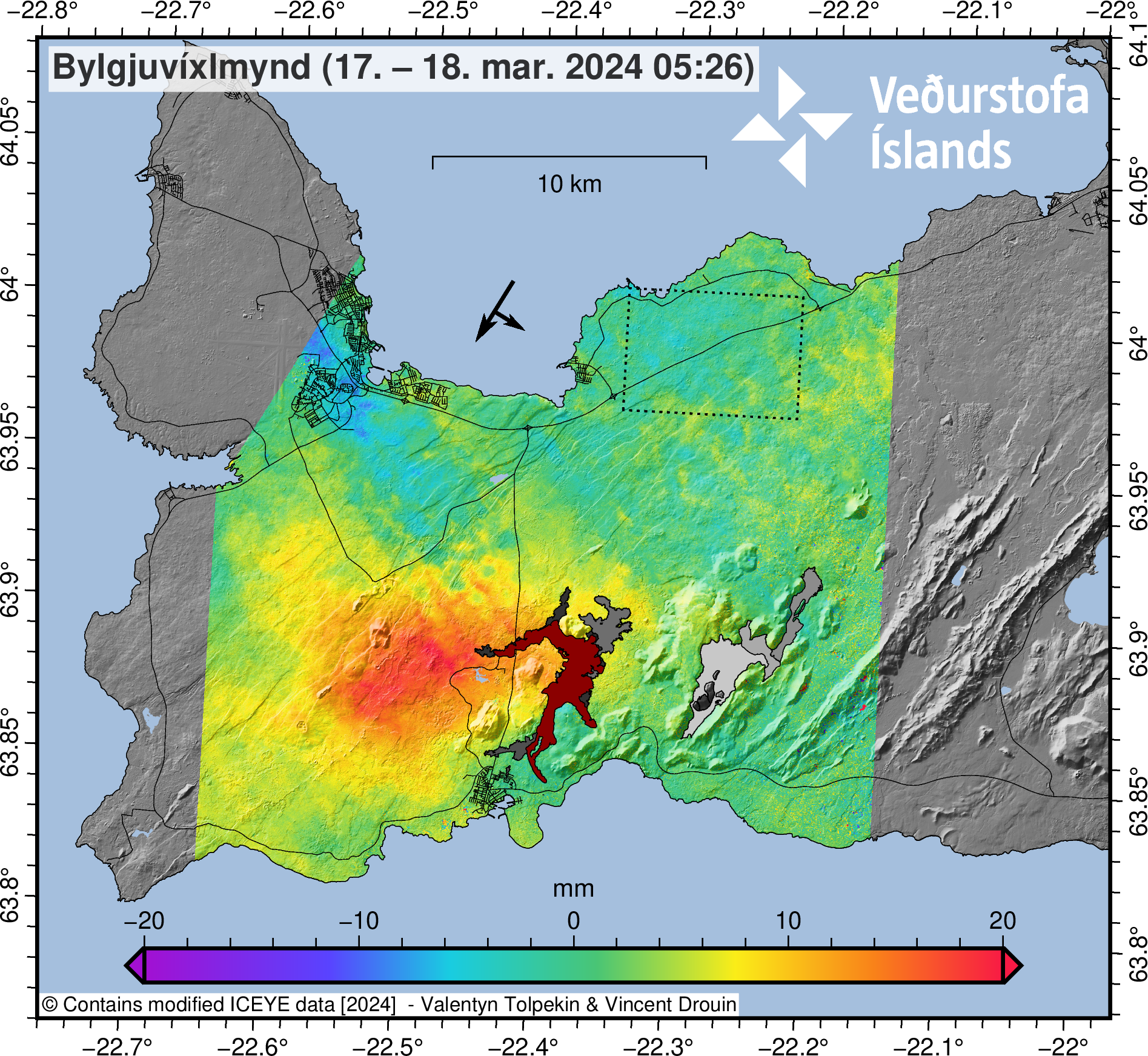
InSAR image showing measured inflation (red areas)
between 17 and 18 March after the eruption began. The image is based on data
from the ICEYE satellite
According to measurements carried out last night, the outflow of gas from the eruption has decreased compared to what it was at the beginning of the eruption. However, it is still likely that gas pollution will be detected, and the weather forecast indicates increasing south-westerly winds, around 13-20 m/s at the eruption site today, but winds will decrease this evening. Gas pollution is thus directed to the north-east. See gas distribution forecast here.
The hazard assessment map updated yesterday remains unchanged until 15:00 tomorrow 20 March, barring any changes to the situation.
Updataed 18. March at 18:30 UTC
The Icelandic Meteorological Office has updated the hazard assessment to account for the latest data. The new hazard assessment takes effect today, Monday, March 18, and is valid until March 20, unless the situation changes. Zone 3 (the Sundhnúkur crater row), where the volcanic eruption is still ongoing, remains unchanged, with the hazard level remaining very high. The hazard level is assessed to remain high in Zone 1 (Svartsengi) due to gas emissions and lava flows. The same applies to Zone 4 (Grindavík), where the danger due to sinkholes above fissures, fault movements, lava flows, and gas emissions is considered high. Zone 5 has been downgraded to considerable risk (orange) and Zone 7 is now downgraded to some risk.
The reason for assessing the danger as greater in Zone 1 than in Zone 5 is the closer distance to the active end of the eruptive fissure. The weather forecast and gas dispersion forecast for the next few days will affect the assessment of gas pollution and ash in the hazard assessment.

Updated 18. March at 16:50 UTC
- The volcanic eruption's activity has been relatively stable since late yesterday.
- There is a very slow movement of the lava flow towards the road Suðurstrandarvegur.
- This morning, the lava flow was approximately 330 meters from the road. The margin has not advanced significantly since yesterday evening.
Eruptive activity has been relatively stable since yesterday afternoon. The eruption is focused at two locations along the eruptive fissure, but the northernmost craters that were active yesterday are not active now. The most active areas are near the southern end of eruptive fissure that opened on Saturday evening, with lava flowing from these locations southward towards the road Suðurstrandarvegur. This morning, the lava flow was approximately 330 meters from the road, with minor movement of the margin since yesterday evening. Observations of the area yesterday evening indicate that there is not significant activity or movement of the lava flow that crossed the road Grindavíkurvegur few hours after the eruption started.
The extent of the new lava is estimated to be 5.85 square kilometers, based on satellite imagery acquired at 14:56 yesterday, March 17. See the accompanying map. This area estimation, based on satellite data, contains greater uncertainty than calculations based on aerial photographs. If weather conditions allow, an aerial survey of the eruption site will be conducted later today, providing more accurate calculations of the area and volume of lava.
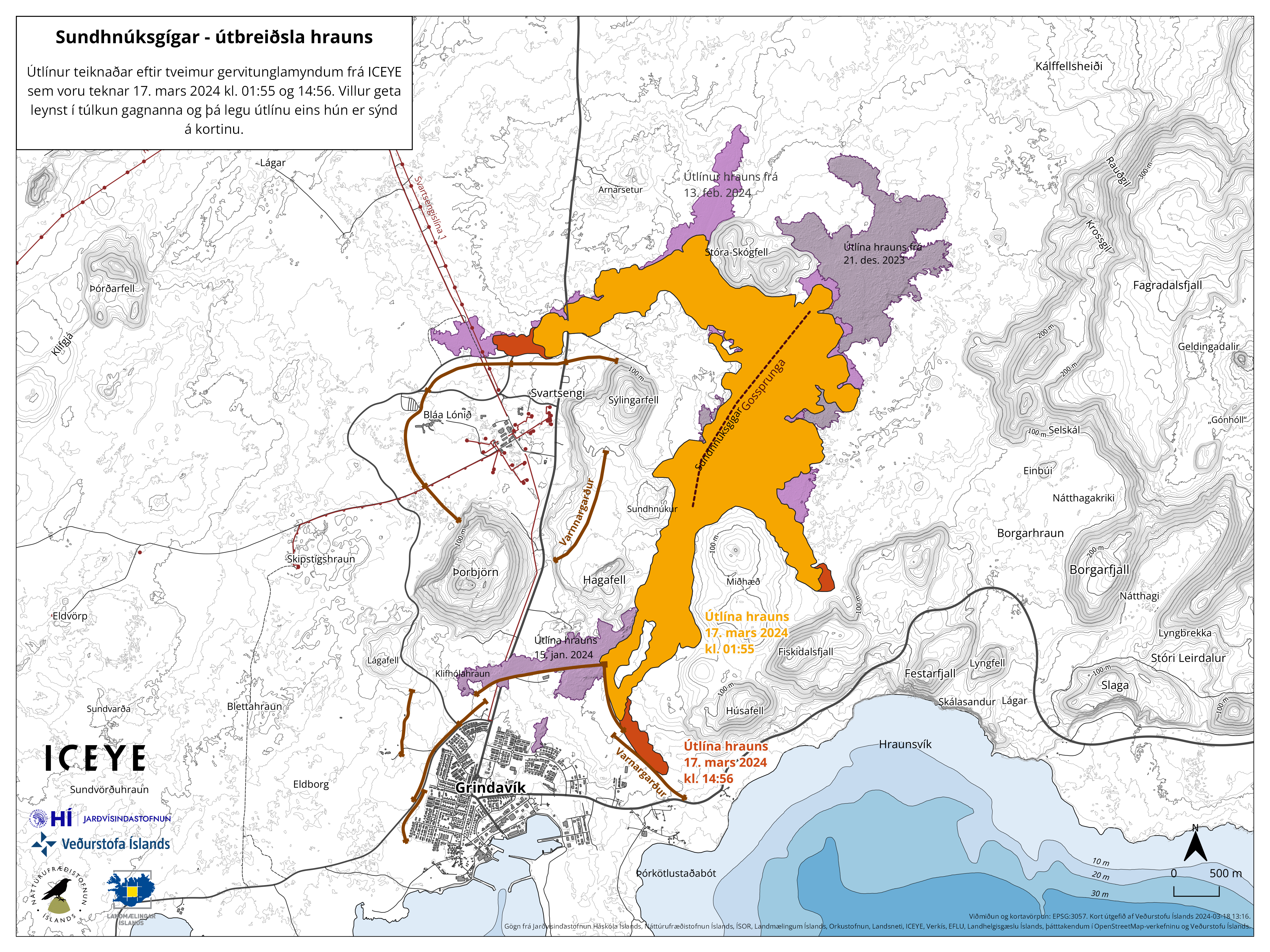
The outlines of the lava flow are drawn from satellite images from Iceye. The first image was taken on March 17 at 01:55 (orange color), which is about five and a half hours after the eruption began. The second image was taken at 14:56 on March 17, showing the outlines of the lava, as it was then, shown in red. Purple colors indicate lava flows from previous eruptions.
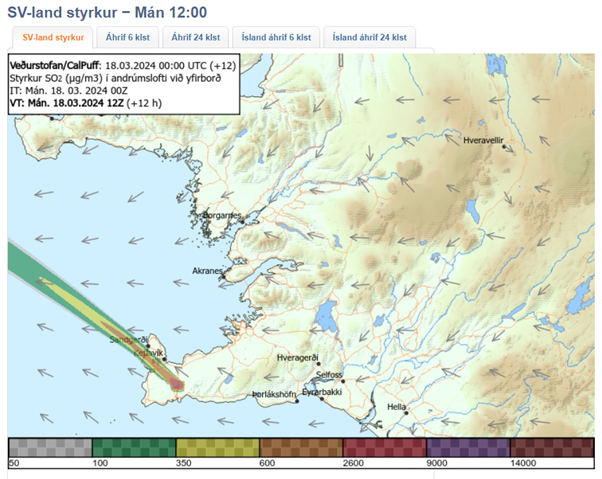
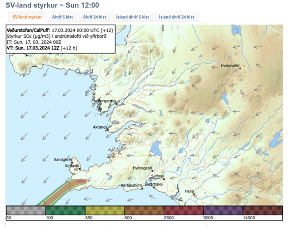
The weather forecast for later today brings wind from the southeast and east with a speed of 8-13 m/s at the eruption site, followed by decreasing winds from the south and southwest. Gas emissions will therefore drift northwest and west, with a shift to the north later today. Significant uncertainty exists in the strength of gas emissions. Wind from the southwest with a speed of 10-18 m/s is expected tomorrow morning, so the gas emissions will then travel to the northeast. It is unlikely that gas emissions will reach the Capital Region due to strong winds. The gas dispersion forecast can be monitored here.
There is minor seismic activity near the eruption site and throughout the Reykjanes Peninsula. Only a handful of small earthquakes have been observed. The risk assessment will be updated later today.
Updated 17. March at 18:40 UTC
Since 04:00 UTC today, the propagation of lava has slowed substantially. However, the eruption has not ended, and lava continues to be extruded from a 0.5-km-long fissure, as confirmed by web camera and drone imagery. A lava front extends to the west from Sundhnúkur crater row. This front inundated Grindavíkurvegur in the early hours of Sunday morning at around 00:30 UTC, making the road impassable.
Lava also travelled southwards, and it is now less than 250 m from Suðurstrandarvegur – the main road on the southern coast of the Reykjanes Peninsula. Between 10:15 and 16:30 UTC today, this lava front moved at an average speed of 12 m per hour. Assuming the same speed of movement, it will take the front an additional ~20 hours to reach the main road. In the event of the lava reaching the road, an additional 350 m of propagation would be needed before lava could enter the sea.
Below is a map showing the impact area if the lava were
to reach the sea. This scenario and response plans related to it have been
discussed at status meetings of the Meteorological Office and Civil Protection
yesterday and today.

In the event of lava interacting with seawater, there would be a range of volcanic hazards due to the sudden cooling of lava. Initially, these hazards would comprise localised tephra deposition (solid volcanic particles) and the formation of volcanic gases, principally hydrogen chloride (HCl). Within a radius of 0.5 km from the entry point into the sea, there would be potentially lethal health hazards. With increasing distance, the severity of the volcanic hazards decreases over a radius of 3 km. Beyond that distance, health hazards due to gas pollution would be minor in nature.
Based on the development of the eruption today, our assessment is that lava flow into the sea is an unlikely scenario. However, until the eruption ends, and lava propagation stops entirely, it remains an outcome to consider for hazard assessment purposes. Assuming the same speed of movement (12 m per hour), it would take the southern lava front two days to reach the coastline.
Updated 17. March at 13:00 UTC
The volcanic eruption that began at 20:23 last night continues, but during the night the intensity of the eruption decreased, and now there are three active openings on the eruptive fissure. Seismic activity also significantly decreased overnight, with very few earthquakes measured after 3:00, coinciding with a decrease in volcanic tremor. This development is very similar to the three previous eruptions on the Sundhnúkur crater row.
Shortly after midnight, lava flowed over the Grindavík road towards the water distribution pipe from Svartsengi power plant. There has been limited advancement in that lava flow front since this morning and it is now about 200 meters from the pipe. Another lava flow front runs alongside the protective barriers east of Grindavík and towards Suðurstrandarvegur road. Response workers in the area are monitoring the lava's advance rate, which has been slow and steady since this morning.
The eruption fissure as it was at 11:00 today. To the right of the image is Mt. Stóra-Skógafell, and to the left is Mt. Sýlingarfell. The most active part of the fissure is east of Sýlingarfell, with smaller openings to the north.
Today's weather forecast is northeast winds of 8-13 m/s with intermittent rain, but the wind will gradually decrease. Gas emissions will mainly drift southwest from the eruption site. Tomorrow, southeast winds of 8-13 m/s are expected with showers, and the gas emissions will likely drift northwest. Temperatures generally range from 1 to 5 degrees Celsius near the eruption sites. There is considerable uncertainty regarding the intensity of gas emissions. See the gas dispersion forecast here.
Updated 17. March at 01:25 UTC
The Icelandic Met Office has updated the hazard map for the area. Lava flow continues to the south and southeast. The speed of the lava front is estimated to be 1 km/hr.
If the eruption continues at the same rate the scenario of lava reaching the ocean needs to be considered.
Now, about five hours into the eruption, the activity has been fairly constant for the whole length of the fissure.

Updated 16. March at 23:50 UTC
A volcanic eruption has begun between Mt. Hagafell and Mt. Stóra Skógfell. The eruption began at 20:23 UTC on 16 March, with a 2.9-km-long fissure forming quickly. The length and location of the fissure is similar to the eruption on 8 February 2024.
The pre-eruptive warning phase
was very short. The first warning to the Department of Civil Protection and
Emergency Management was at 19:43 UTC, and the onset of eruption was confirmed
on web cameras just 40 minutes later. The eruption is effusive in nature, so the
eruption plume consists mainly of steam and gas.
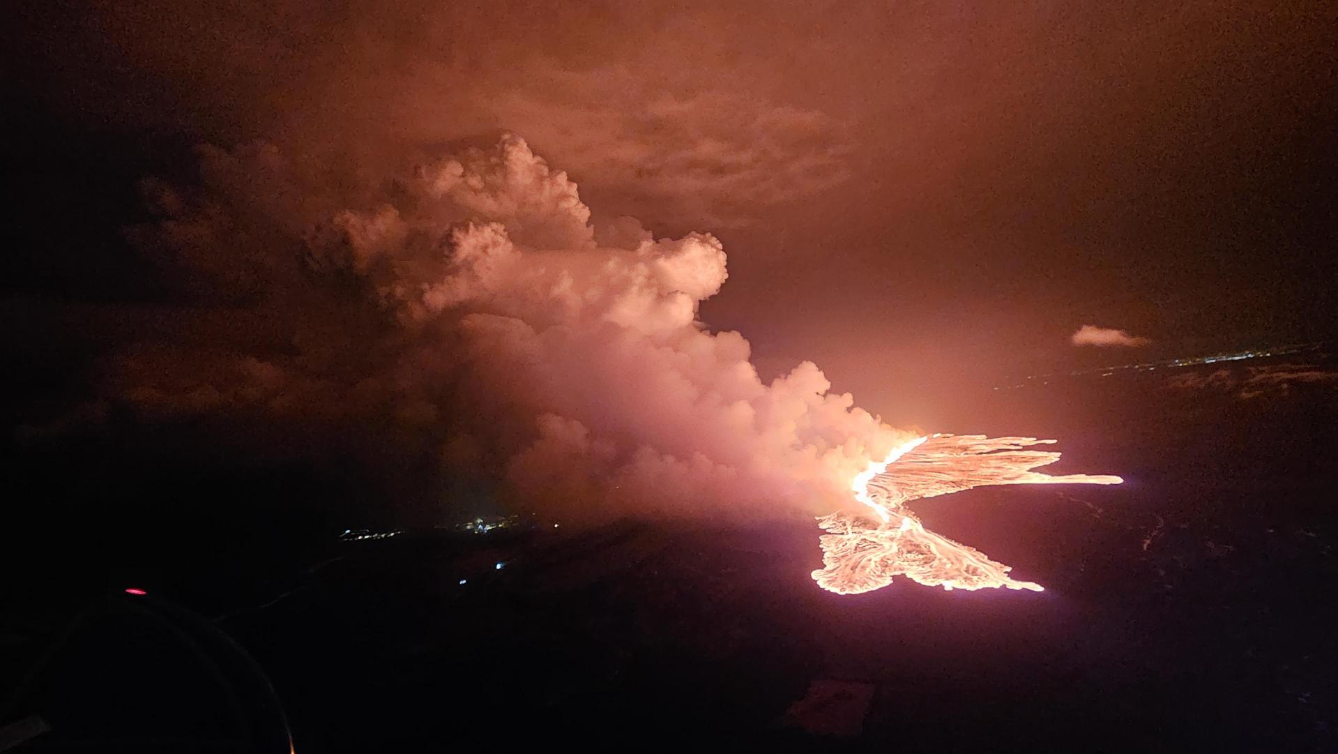
Picture showing the status of the eruption at 21:40. (Photo: DCPEM/Björn Oddsson)
The Icelandic Coast Guard performed a helicopter flight over the eruption area. The flight had experts from IMO, the University of Iceland, the Department of Civil Protection and Emergency Management. Lava is flowing westwards from the eruption fissure in the direction of Grindavíkurvegur (road) and the protection barriers for the Svartsengi region. Additionally, a large lobe of lava is flowing southeast, towards the protection barriers for Grindavík.
The map shows the fissure opening in red. Orange lines shows lava barriers.
From initial assessments of web camera imagery and aerial photographs from the helicopter flight, the eruption is thought to be the largest (in terms of magma discharge) of the three previous fissure eruptions from the Sundhnúkur crater row. This estimate applies to the first hour of eruptive activity.
At 22:10 UTC, the southern lava
front was just 200 m from the barriers on the eastern side of Grindavík and
moving at a rate of about 1 km per hour. At 22:20 UTC, lava was 700 to 800 m away
from Grindavíkurvegur, nothwest of Grindavík, moving at a rate of approximately
1 km in 1.5 hours.
Updated 15. March at 14:30 UTC
Higher uncertainty than before
about the timing of the next dike intrusion and possible eruption.
GNSS displacements and recent interferograms show continued inflation of the Svartsengi magma reservoir – at a similar rate to that observed prior to the diking event on 2 March 2024. Geodetic modelling using these datasets confirms the inflation source is also at a similar location and depth as that observed during previous inflation episodes.
The models inditate a recharge volume of approx. 4 million cubic meters to the Svartsengi reservoir since 3 March.
For the diking events that occurred between 14 January to 2
March, the failure limit calculated to trigger these dike intrusions and/or
eruptions was consistently estimated at around 10 million cubic meters. This
enabled longer-term forecasts to be made based on the volume loss from the
magma reservoir during the diking events and then estimating the time window
when this amount would be fully recharged, hence triggering the next event.
However, on 2 March it is estimated that a much smaller volume was lost from the magma reservoir during this event (approx. 1.3 million m3) which triggered a small dike intrusion that did not result in an eruption.
A larger volume, compared to the amount lost from the Svartsengi reservoir on the 2 March, has now been recharged, yet a new dike intrusion/eruption has not yet occurred. This indicates a possible change in the magma plumbing system and greater uncertainty in the new failure limit that now needs to be reached, and thus the timing, of the next dike intrusion and/or eruption.
When this new limit is reached, the most likely scenario is another dike intrusion within the existing diking area – between Stóra-Skogfell to Grindavík – which may or may not culminate in an eruption.
Seismicity NW of Grindavík not a sign of dike intrusion there
We cannot rule out the possibility of an eruption occurring within an adjacent area or volcanic system e.g. west of Mt Þorbjörn or in Eldvörp, however, prior to this occurring a new dike will first need to be intruded in the corresponding area.
There is currently no evidence of a dike intrusion within these areas. Such an intrusion in a new area, is expected to be characterised by a strong earthquake sequence, and large amounts of ground deformation detected on both the GNSS network and on interferograms – none of these monitoring datasets currently show any evidence of this.
There has been an increase in seismicity (all earthquakes < M1.5) to the north west of Grindavík. It is likely that the continued inflation of the Svartsengi magma reservoir is now triggering small movements on pre-existing faults in this area that were activated during the 10 November 2023 diking event.
The map shows seismicity detected from 3 March to 14 March. Black lines outline Grabens that formed in diking events on 10 November 2023 and 14 January 2024.
Updated 12. March at 17:00 UTC
- The volume of magma beneath Svartsengi continues to increase, which could result in a new dike intrusion and possibly an eruption.
- An eruption could occur with very short notice, possibly less than 30 minutes.
- The most likely eruption site is between Stóra-Skógafell and Hagafell.
Model calculations show that magma accumulation at Svartsengi continues at a steady rate. In previous events a magma intrusion has formed when the volume of accumulated magma has reached 8 to 13 million cubic meters. The total volume accumulated now has already reach this threshold. Pressure buildup therefore continues to increase in the magma chamber and likelihood of a new dike intrusion and even an eruption in the next days is increased.
140 earthquakes have been detected in the vicinity of the Sundhnúkur crater row and Grindavík since Friday. The majority of these earthquakes have been minor or below magnitude 1.0 whilst the largest measured event was a M2.8 on Friday evening, at around 5km depth just SE of Þorbjörn. Seismic activity in the area has increased slightly in the past few days compared to last week, which can possibly be linked to calmer winds and optimal weather conditions for earthquake detections.
The IMO has updated the hazard assessment
map. The hazard level remains unchanged from the last map. The new hazard assessment map
took effect at 15:00 today, Tuesday, March 12th and is valid until March 19th,
barring any changes to the situation.
 '
'(Click on the image to see it larger)
Unusually rythmic pattern of unrest, upto this point.
As reported last week, the behavior of the dike propagation on March 2nd differed in some ways to the previous dike formations. Scientists will continue to gather data and infer if the event on March 2nd indicates possible changes to the unusually rythmic pattern of unrest with magma accumulation at Svartsengi and repeated dyke intusions and eruptions.
These events of unrest have previously been compared to the unrest in Krafla that started in 1975. During a period of 10 years, 20 magma intrusions occurred with 9 of them culminating in a volcanic eruption (See image below). In the Krafla unrest magma always intruded into the same dike, but at different scales of magnitude. However, the eruptions did not follow a similarly regular pattern as observed so far in the Sundhnúkar crater row and has in fact been unusually rythmic.

The image shows the interaction between magma
intrutions and ground uplift in the center of the Krafla caldera. The graph
below shows the elevation of measurement point within the Krafla caldera and
the graph above shows the distance from the caldera to the dike formations.
Updated 7. March at 17:00 UTC
Likely sequence of events over the next several days:
- The volume of magma beneath Svartsengi continues to increase, which could result in a new dike intrusion and possibly an eruption.
- An eruption could occur with very short notice, possibly less than 30 minutes.
- The most likely eruption site is between Stóra-Skógafell and Hagafell.
Seismic activity associated with the volcanic unrest has been decreasing since Saturday, with very few earthquakes detected in the past few days. However, unfavorable weather conditions have disrupted seismic monitoring by dampening small events, so there have likely been additional minor earthquakes that could not be detected.
Weather conditions over the next 24 hours will likely hinder the Meteorological Office's earthquake monitoring system. The forecast indicates that Reykjanes will experience strong winds from the southeast accompanied by rain and limited visibility, especially in mountainous regions. Precipitation will decrease in the early morning, with occasional showers coinciding with reduced visibility expected tomorrow and the following days. Winds are expected to decrease over the weekend, coming from the southeast or northwest on Sunday.
Inflation continues at Svartsengi, and model calculations based on GNSS data from March 3rd to 6th indicate that approximately 1.2 million cubic meters of magma has been injected into the magma chamber during these days. Therefore, approximately 10 million cubic meters of magma has accumulated in the magma chamber overall since the last eruption. The current situation is therefore similar to what it was before the eruption on March 2nd.
Updated hazard assessment
The Meteorological Office has updated the hazard assessment map. The hazard level remains unchanged from the last map. One change has been made to the zoning; Zones 2 and 3 have been merged into one single zone. Given the development of the activity, there is no longer a reason to assess the risk in these areas separately. The new hazard assessment map took effect at 3 p.m. today, Thursday, March 7th. This hazard assessment is valid until March 12th, barring any changes to the situation.

(Click on the map to see it larger)
Updated 5. March at 14:20 UTC
Likely scenarios over the next few
days:
- The volume of magma within the Svartsengi reservoir continues to increase, which could result in a new dike propagation and/or volcanic eruption in the coming days.
- A volcanic eruption could start with a very short warning time, even less than 30 minutes.
- It is most likely that an eruption will occur in the
area between Mt. Stóra-Skógfell and Mt. Hagafell.
Seismicity over the dike has been low since the magma propagation ended on Saturday (2 March) evening. There is slightly more activity at Mt. Fagradalsfjall, where around 20 earthquakes have been detected in the last 24-hours.
Model calculations indicate a volume loss of about -1.3 million cubic metres from the Svartsengi magma reservoir on Saturday – which fed a 3-km long dike intrusion between Mt. Stóra-Skógfell and Mt. Hagafell. The volume loss from the Svartsengi reservoir was much lower than that which occurred during previous events, where a volume loss of about -10 million cubic metres was calculated.
Continuous land uplift is detected on GNSS observations since Saturday‘s magma propagation. Magma inflow beneath Svartsengi thus continues and model calculations suggest an inflow/accumulation rate of about half a million cubic metres per day. In total, about 9,5 million cubic metres of magma has been recharged to the reservoir beneath Svartsengi since the eruption on 8-9 February.
Therefore, pressure in the magma reservoir continues to build up, and there is an increased likelihood of another dike propagation within the Sundhnúkur crater row and/or a volcanic eruption in the coming days.
The graph shows a comparison of volume increase within the Svartsengi reservoir prior to dike propagations and/or eruptions. The status of the volume change as of 4 March is indicated by the red line. This line also shows what affect the magma propagation on the 2 March had on the accumulation process within the magma reservoir beneath Svartsengi. The quantities displayed on this graph are derived from model calculations based on GNSS data alone. Joint InSAR-GNSS modelling of the diking event on Saturday indicates a volume loss of about -1.3 million cubic metres from the Svartsengi reservoir which fed the dike propagation within the Sundhnúkur crater row, without resulting in an eruption. Values derived from both the GNSS only and the joint InSAR-GNSS inversions are subject to uncertainty.
Weather conditions might affect IMO‘s monitoring systems.
The Icelandic Meteorological Office has updated the hazard assessment map, which is unchanged from the previous hazard assessment. The new hazard assessment is valid until Thursday, 7 March, unless developments in activity call for a re-evaluation.

The weather over the next few days is likely to affect the monitoring systems. The forecast for the week is southeasterly and easterly winds, around 10-15 m/s. Rain showers most days with increasing windspeeds and more calmer winds in between showers.
Updated 4. March at 16:00 UTC
Likely scenarios over the next few days:
- The volume of magma beneath Svartsengi continues to increase, which could result in a magma propagation and even a volcanic eruption.
- A volcanic eruption could start with a very short warning time, even less than 30 minutes.
- It is most likely that an eruption will occur in the area between mt. Stóra- Skógfell and mt. Hagafell.
Model calculations suggest that the volume of magma which propagated from Svartsengi to the Sundhnúkur crater row was around 1.3 million cubic metres.
It had previously been calculated that about 0.5 million cubic metres of magma accumulates beneath Svartsengi each day. Considering this, the total amount of magma beneath Svartsengi will be around 9 million cubic metres by the end of tomorrow, Tuesday 5 March.
In previous events, magma has propagated once the total volume of magma accumulated beneath Svartsengi reaches between 8-13 million cubic metres. Therefore, there is an increased likelihood of new magma propagation and volcanic eruption once these conditions are met.
However, it should be noted also, that after repeated eruptions in mt. Fagradalsfjall, there were examples of magma reaching slowly to the surface without much seismic activity. This sort of development should also be expected on the Sundhnúkur crater row.
Updated 3. March at 12:15 UTC
Likely scenario over the next few days
- Magma volume beneath Svartsengi continues to increase, which could lead to another magma propagation and even a volcanic eruption.
- A volcanic eruption could start with a very short warning time, event less than 30 minutes.
- A volcanic eruption is most likely to occur in the area between mt. Stóra-Skógfell and mt. Hagafell.
The Icelandic Meteorological Office has updated the hazard assessment map due to the decrease in seismic activity in the Reykjanes peninsula.
Considering the
developments in activity since yesterday, the hazard level has been lowered in
two zones - Zones 2 and 3. The hazard level remains unchanged in other areas,
thus the hazard assessment is now the same as it was prior to yesterday‘s
event.
The hazard assessment map is valid from 13:00 UTC today, 3 March, until 15:00 Tuesday 5 March unless development in activity call for a re-evaluation.

(Click on the map to see it larger)
Updated 3. March at 11:50 UTC
Seismic activity at mt. Sýlingarfell was due to a magma intrusion. The seismic activity started around 16:00 UTC yesterday (2 March) and subsided steadily after 18:00 and after 20:00 it was mostly over.
Data indicate that yesterday‘s
magma intrusion has stopped by mt. Hagafell. The likelihood of magma ascending
in relation to this magma intrusion has decreased but the area continues to be
closely monitored for this possibility.
Model calculations indicate that the volume of magma that propagated out of Svartsengi yesterday was negligible comparted to previous magma propagations which culminated with an eruption.
Therefore, it can be assumed that magma accumulation beneath Svartsengi is continuing as before and that the volume of magma which has already been accumulated suffices to trigger another magma propagation. It can be expected that another magma propagation can occur in the next few days and there continues to be an increased likelihood of an eruption, as before yesterday‘s event.
This depends on how quickly the pressure caused by magma accumulation under Svartsengi builds up to trigger another magma propagation.
Considering these developments, The Icelandic Meteorological Office is working on a new hazard assessment map which will be updated in the coming hours.
Likely scenarios over the next few days:
- Magma volume beneath Svartsengi continues to increase, which could lead to another magma propagation and even a volcanic eruption.
- A volcanic eruption could start with a very short warning time, event less than 30 minutes.
- A volcanic eruption is most likely to occur in the area between mt. Stóra-Skógfell and mt. Hagafell.
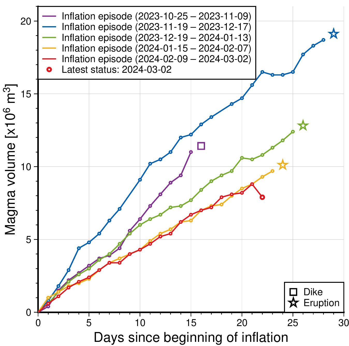
The graph shows a comparison of
volume of magma accumulated beneath Svartsengi before it propagates towards
Sundhnúkur crater row. The status of the magma volume at 2. March after the magma propagation er indicated with red colour. The amount is derived through model
calculations based on GPS data and subject to uncertainties. Changes can vary
from day to day, from being small to more prominent changes. The purple line
shows the magma volume accumulated prior to the large diking event beneath
Grindavík formed on the 10th of November 2023.
Updated 2. March at 19:10 UTC
At this point, the seismicity that began just before 16:00 UTC today has ceased. It is thus considered likely that the magma intrusion has stopped temporarily or is significantly diminished. However, minor deformation continues to be measured in the area, so it is too early to assert that the magma intrusion has ended, and that there will not be an eruption at this time. When magma intrusions occur, deformation can be measured for several hours after the seismic activity stops.
The Icelandic Meteorological Office continues to monitor the area to observe whether the activity resumes in the next few hours, or if the magma intrusion has halted completely. It remains possible that magma could ascend to the surface, as has been observed in eruptions near Fagradalsfjall.
Updated 2. March at 17:30 UTC
- An intense swarm of microseismic activity is occurring east of Sýlingarfell on the Reykjanes Peninsula.
- The seismicity indicates that magma movements have begun, and that a fissure eruption is likely.
- The seismicity began at the southern end of the fissure that formed on 18 December 2023.
As of 17:30 UTC, it is apparent that the seismic activity has moved southwards in the direction of Hagafell.
- Real-time, GPS-based measurements show much less signs of deformation than before previous eruptions since December 2023. This could signify that less magma is on the move than before the previous three eruptions on Sundhnúkur crater row.
- At present, the depth of the seismicity does not indicate that magma is propagating to the surface.
- As of 17:30 UTC, the likely scenario is that the magma intrusion will not necessarily lead to a volcanic eruption. However, while the situation remains uncertain, a imminent fissure eruption cannot be ruled out.
A new hazard
assessment map from IMO was published today and is valid until tomorrow (3. March 2024) at 17:00 UTC

Updated 29. February at 12:30 UTC
- An eruption could start with very little warning time, even less than 30 minutes.
- Eruption location is most likely in the area between Mt. Stóra-Skógfell and Mt. Hagafell.
- The hazard assessment does not account for weather conditions or other factors that may affect the risk of being within the hazard zones.
- It is possible that a dike intrusion occurs without resulting in a volcanic eruption.
Model calculations suggest that as of today, about 8.5-9 million cubic metres of magma has accumulated beneath Svartsengi. The rate of the inflation has been fairly constant for the past days. In previous developments, the rate of inflation has decreased shortly before an eruption starts.
According to model calculations, approximately 0.5 million cubic metres of magma is accumulated in the Svartsengi reservoir every 24 hours.
Considering precursors of previous volcanic eruption in the Sundhnúkar crater row, likelihood of a volcanic eruption increases once the volume of magma reaches 8 – 13 million cubic metres. If magma accumulation continues at the same rate, the amount should reach the upper limit next week.
There remains an increased likelihood of a volcanic eruption in the coming days. The most likely scenario is that a volcanic fissure opens in the area between mt. Stóra-Skógfell and Mt. Hagafell which could occur with a very short warning time.
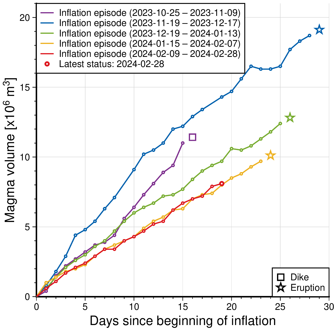
The graph shows a comparison of volume of magma accumulated beneath Svartsengi before it propagates towards Sundhnúkur crater row. The status of the magma volume at 28th of February is indicated with red colour. The amount is derived through model calculations based on GPS data and subject to uncertainties. Changes can vary from day to day, from being small to more prominent changes. The purple line shows the magma volume accumulated prior to the large diking event beneath Grindavík formed on the 10th of November 2023.
A new hazard assessment map from IMO was published today and remains unchanged from the previous one. The hazard assessment map is valid until 5th of March unless developments in activity call for a re-evaluation. Likely scenarios presented earlier this week also remain unchanged (see news from 26th of February).
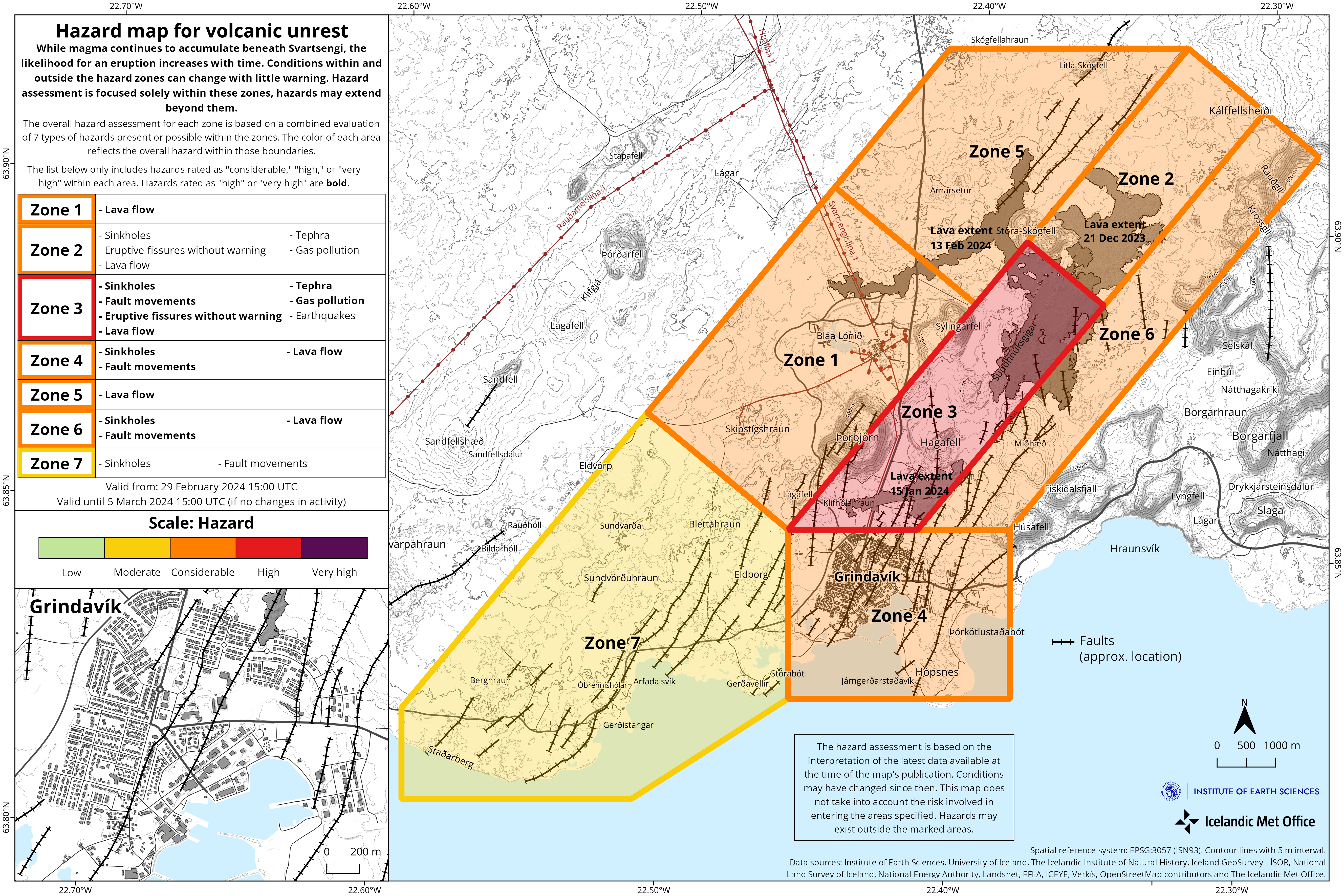
Please note that although IMO has at this point not increased hazard level on the unrest area, developments can occur very quickly and without warning. People entering the unrest area need to keep this in mind. The hazard assessment by IMO does not account for weather conditions or other factors which may affect the risk involved when being within a hazardous area.
Updated 27. February at 13:00 UTC
- Accumulated magma beneath Svartsengi reaching same amount as prior to previous eruptions.
- An eruption could start with very little warning time, even less than 30 minutes.
- Raised hazard levels in an updated hazard assessment due to impending eruption.
- Eruption location is most likely in the area between Mt. Stóra-Skógfell and Mt. Hagafell.
- The hazard assessment does not account for weather conditions or other factors that may affect the risk of being within the hazard zones.
- It is possible that a dike intrusion occurs without resulting in a volcanic eruption
Model calculations suggest that about 7.6 million m3
of magma has been recharged within the Svartsengi reservoir. Considering
precursors of previous volcanic eruption in the Sundhnúkar crater row,
likelihood of a volcanic eruption increases once the volume of magma reaches 8
– 13 million m3. If magma accumulation continues at the same rate,
the amount should reach the lower limit tomorrow (27th of February).
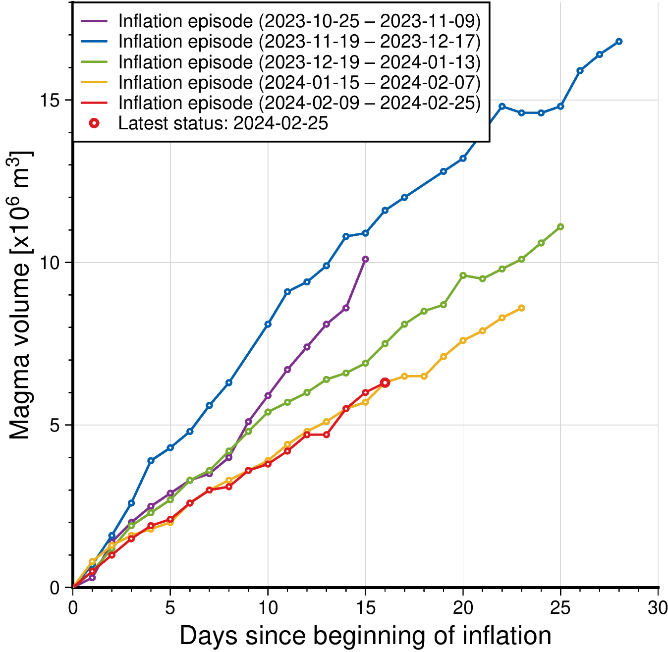
Seismic activity has increased slightly since past weekend and has been most prominent just east of Mt. Sýlingarfell. The location of the seismic activity is in an area which is considered to be the eastern tip of the magma reservoir which is centered beneath the Svartsengi-Þórbjörn area. The current seismicity is similar to that observed days before previous volcanic eruptions in the area.
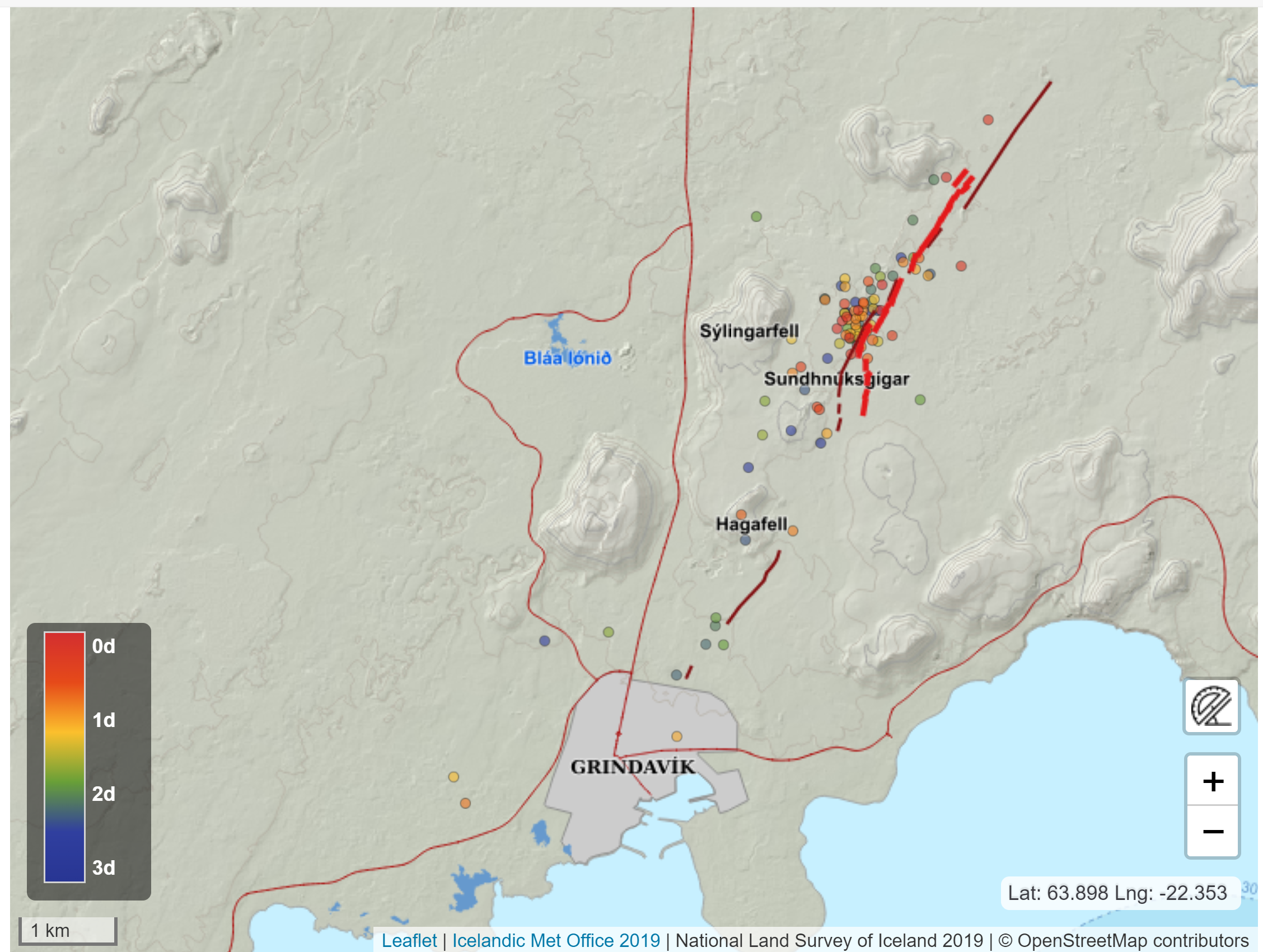
Therefore, IMO has updated the hazard assessment for the unrest area. Increased likelihood of a volcanic eruption and related hazards affects the assessment. Hazard levels have been raised in several zones. Even though the color of Zone 4 – Grindavík - remains unchanged, the hazards there have increased due to the possibility of lava flows. Same goes for Zone 1 – Svartsengi.

No significant deformation within Grindavík has been detected by GNSS or satellite data. It is however likely that new faults will be revealed when snow melts or precipitation causes soil, which might be covering faults, to be washed away.
Likely scenarios
If an eruption occurs, scientists estimate that magma
will most likely propagate from the reservoir beneath the Svartsengi-Þórbjörn region
towards Sundhnúkur crater row, resulting in lava fountaining and lava flows in
the area between Stóra-Skógfell and Hagafell. The primary signal of ascending
magma is a sudden increase in seismic activity with many localized, small
magnitude earthquakes. Considering the previous volcanic eruptions in the area,
an eruption could start with very little warning (less than 30 minutes),
depending on where magma reaches the surface on the Sundhnúkur crater row.
At a community meeting held today with residents of Grindavík, IMO presented results from lava flow models, showing scenarios considered to be likely and which were explained before last weekend.
The modelled results presented showed estimated lava flow from two separate eruptive fissures located on the Sundhnúkur crater row. The lava flow models do not forecast the behaviour of the next volcanic eruption. The models are only used to predict possible lava flow pathways from different locations of eruptive fissures.
Many factors affect a lava flow: location and length of the eruptive fissure, volume of erupted material, topography of the land surface and whether craters or lava lobes form.
These modelled scenarios predict lava flowing from an 800 m long eruptive fissure with a constant extrusion rate of 600 m3/s. The fissures are shown on the maps as black lines.
These modelled results below are therefore only 2 examples for the Sundhnúkar crater row, but the behaviour of the lava flow in the next volcanic eruption can be very different depending on where exactly a fissure opens on the surface and how long it will be. A minor shift in location can significantly alter the lava flow pathway.
Eruption
between Sýlingarfell and Stóra-Skógfell - As occurred on December 18, 2023 and February
8, 2024.
- Precursor: Sudden, localized, and intense seismic activity with small magnitude earthquakes. Deformation over the magma dike (if a dike is intruded) and the Svartsengi magma reservoir
- Very short warning time (less than 30 minutes) because a new dike propagation may not be required for magma to reach the surface.
- Lava reaches Grindavík road within 2 to 4 hours, but possibly less, if the velocity of the advancing lava front is higher than that observed during previous eruptions

The modelled results presented showed estimated lava flow from a fissure just south of Stóra-Skógfell. The lava flow models do not forecast the behaviour of the next volcanic eruption. The models are only used to predict possible lava flow pathways from different locations of eruptive fissures. The velocity of the advancing lava front can also be higher than that shown in the model.
Eruption by Hagafell – As occurred on January 14, 2024.
- Precursor: Seismic activity with small magnitude earthquakes on the Sundhnúkur crater row, starting near Sýlingarfell and migrating south. Deformation over the magma dike and the Svartsengi magma reservoir
- Likely warning time is approximately 1-3 hours from the detection of the first earthquakes until the start of an eruption.
- Lava reaches the lava barriers around Grindavík within 1 hour.
- Magma intrusion, which reaches south of Hagafell, will likely cause significant fault movements in Grindavík

The modelled results presented showed estimated lava flow from a fissure west of Hagafell. The lava flow models do not forecast the behaviour of the next volcanic eruption. The models are only used to predict possible lava flow pathways from different locations of eruptive fissures. The velocity of the advancing lava front can also be higher than that shown in the model.
Eruption inside of the lava barriers around Grindavík
- Seismic activity with small magnitude earthquakes on the Sundhnúkur crater row, starting near Sýlingarfell and migrating south. Deformation over the magma dike and the Svartsengi magma reservoir
- Probable warning time is between approximately 1-5 hours from the detection of the first earthquakes until the start of an eruption.
- It is possible that an eruptive fissure/s will open within Grindavík or the region just north of here (inside the barriers). Similar activity occurred on the 14th of January when a volcanic fissure opened just inside the outer perimeter of the town approximately 4 hours after an onset of the eruption near Hagafell.
- Magma intrusion, which reaches south of Grindavík, will cause significant fault movements in Grindavík.
The Icelandic Meteorological Office and the University of Iceland have compiled material that describes the Volcano-tectonic reactivation of the Reykjanes Peninsula since 2019. See here .
Updated 23. February at 15:00 UTC
Model calculations indicate that approximately 5 million cubic meters of magma had recharged to the Svartsengi reservoir as of the 22 February. Considering the trend observed prior to previous volcanic eruptions in the Sundhnúkur crater row, the likelihood of an eruption is very high once the volume reaches between 8-13 million cubic meters (derived from joint InSAR-GNSS models). Based on the results of the model calculations, this could occur early next week if magma accumulation continues at the current rate.
It should be noted that there is a degree of uncertainty in this interpretation, and it cannot be assumed that the behaviour will be identical to the past eruptions here. Also, as the magma plumbing system evolves, we cannot rule out the possibility that the volume of magma required to trigger a new diking event and/or eruption may become reduced.
Additionally, there is a possibility a new dike intrusion occurs within this region without resulting in a volcanic eruption.
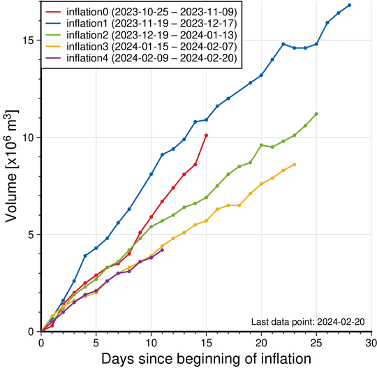
Figure: The graph displays a comparison of the volume of magma accumulated beneath Svartsengi before the magma flowed towards the Sundhnúkur crater row during the recent dike intrusions and eruptions that occurred between December 2023-February 2024. The volume is calculated by a model based on GNSS data and is subject to uncertainty. Significant variations can also be observed between consecutive days. The current magma accumulation status as of February 22 is marked by the purple line. The red line shows the amount of magma accumulated before the major diking event beneath Grindavík on November 10th.
If an eruption occurs, scientists estimate that magma will most likely propagate from the reservoir beneath Svartsengi towards Sundhnúkur crater row, resulting in lava fountaining and lava flows in the area between Stóra-Skógfell and Hagafell. The primary signal of ascending magma is a sudden increase in seismic activity with many localized, small magnitude earthquakes. Considering the previous volcanic eruptions in the area, an eruption could start with very little warning (less than 30 minutes), depending on where magma reaches the surface on the Sundhnúkur crater row.
Likely scenarios
Eruption between Sýlingarfell and Stóra-Skógfell - As occurred on December 18, 2023 and February 8, 2024.
- Precursor: Sudden, localized, and intense seismic activity with small magnitude earthquakes. Deformation over the magma dike (if a dike is intruded) and the Svartsengi magma reservoir
- Very short warning time (less than 30 minutes) because a new dike propagation may not be required for magma to reach the surface.
- Lava reaches Grindavík road in less than 4 hours.
Eruption by Hagafell – As occurred on January 14, 2024.
- Precursor: Seismic activity with small magnitude earthquakes on the Sundhnúkur crater row, starting near Sýlingarfell and migrating south. Deformation over the magma dike and the Svartsengi magma reservoir
- Likely warning time is approximately 1-3 hours from the detection of the first earthquakes until the start of an eruption.
- Lava reaches the lava barriers around Grindavík within 1 hour.
- Magma intrusion, which reaches south of Hagafell, will likely cause significant fault movements in Grindavík
Eruption inside of the lava barriers around Grindavík
- Seismic activity with small magnitude earthquakes on the Sundhnúkur crater row, starting near Sýlingarfell and migrating south. Deformation over the magma dike and the Svartsengi magma reservoir
- Probable warning time is between approximately 1-5 hours from the detection of the first earthquakes until the start of an eruption.
- It is possible that an eruptive fissure/s will open within Grindavík or the region just north of here (inside the barriers). Similar activity occurred on the 14th of January when a volcanic fissure opened just inside the outer perimeter of the town approximately 4 hours after an onset of the eruption near Hagafell.
- Magma intrusion, which reaches south of Grindavík, will cause significant fault movements in Grindavík.
Although there is clear indication of uplift in the Svartsengi-Þórbjörn area (related to magma recharge of this reservoir) this does not mean that it is the most likely location for an eruption to start. This is because the magma reservoir is currently failing on its northeastern edge feeding dike propagations which are initiated between Stóra-Skógfell- and Sundhnúkur crater row. In a scenario where magma ascends towards the surface directly from the Svartsengi reservoir, it is estimated that the first signs of magma migration would be detected 4-7 hours before magma reaches the surface.
Please note that these scenarios are based on interpretations of the latest data and the observed development of the previous events at the Sundhnúkur crater row area. Uncertainty must be accounted for in this interpretation, as it is only based on few events.
Updated 23. February at 9:30 UTC
Seismic activity in the unrest area north of Grindavík remains minimal. About 20 small earthquakes have been detected on a 24-hour basis for the past days.
Magma accumulation beneath Svartsengi continues and the pace of the accumulation has been quite steady. This is a similar trend as has been observed prior to the previous volcanic eruptions.
The event which started at the end of October 2023 with an inflation at Svartsengi thus continues. Whilst magma accumulation persists, another volcanic eruption is expected in similar areas as before.
Should magma accumulation continue at current pace, the amount will reach a threshold believed necessary to trigger a dyke propagation and even an eruption, by next week. The amount of magma accumulated beneath Svartsengi before previous eruptions is estimated to have been 8-13 million m3. New model calculations are underway to obtain a better understanding of how much magma has now been accumulated.
At the moment, it is not considered necessary to raise the hazard level in the area and thus the hazard assessment issued by IMO remains unchanged.
The hazard assessment will be updated Monday 26th of February and should the development continue at similar rate as now, hazard levels in zones will be raised as more magma will be accumulated and thus there is a higher likelihood of an eruption.

Updated 20. February at 11:00 UTC
The Icelandic Meteorological Office has issued an updated hazard assessment map following the decision of the National Police Commissioner to repeal the order of a temporary evacuation from Grindavík, taking effect on the 19th of February, and due to the decision of the Police Commissioner in Suðurnes regarding changes in access restrictions for both individuals as well as business operations.
An updated hazard assessment map is valid from 20th of February at 7AM, which is the same time as the decision of the Police Commissioner in Suðurnes goes into effect.
In the latest version of IMO's hazard assessment map, Zone 7 has been added in consultation with Civil Protection. Nesvegur road is within Zone 7, which is currently more used to access Svartsengi and Grindavík. Hazards present in Zone 7 are fault movements and sinkholes. Colour code of other areas remain unchanged from previous hazard map.
Read here about the decision of the Police Commissioner in Suðurnes. (Icelandic).
As before, the map shows assessment of hazards currently at hand, as well as hazards which might occur with short notice. An assessment has only been made for hazards within the defined Zones, but hazards can also be present outside of them.

Updated 15. February at 16:00 UTC
Land uplift at Svartsengi area continues at similar trends and rates as has been detected following dyke propagations from there.
Model calculations based on GPS data suggest that magma accumulation from the end of the eruption 9th of February until yesterday, 14th of February, is about 2 million m3. It was estimated that when the eruption began on the 8th of February, about 10 million m3 of magma propagated from Svartsengi towards Sundhnúkur crater row. If magma accumulation continues at same rate, a total of 10 million m3 will be accumulated by the end of February or beginning of March, by which time likelihood of dyke propagation and volcanic eruption will increase significantly. These model calculations are based on GPS data but will be updated when new satellite data comes in.
Seismic activity in the western parts of mt. Fagradalsfjall continues with about 80 small earthquakes of magnitudes 1.5 or smaller detected since 12th of February. The depth of the earthquakes under the western part of mt. Fagradalsfjall is at 6-8 km. The area remains closely monitored but at the moment deformation data do not show signs of magma accumulation.
An updated
hazard map has been published. It is valid until 22nd of February
unless developments call for a re-evaluation. The main changes are that
likelihood of eruptive vents opening has decreased in all Zones. Likelihood of
sinkholes and fault movements are still considered high in Zone 4
(Grindavík). Please note that the hazard zones are active, and changes can
occur with short notice. Furthermore, hazards can be present outside of the
specified hazard zones, such as the faults that formed on the 10th
of November 2023 west of Grindavík (see faults on map).

Updated 12. February at 16:00 UTC
IMO has updated the hazard assessment according to the development of the eruptive activity. Changes have been made to the hazard assessment for some hazards within zones.
The overall hazard assessment for the area remains unchanged from the last map. There is still considered to be a sinkholes and fault movementsn area 4 (Grindavík).

(Click on the map to make it larger)
The hazard assessment map is valid until Thursday, 15 February, unless changes in activity calls for a re-evaluation.
Updated 12. February at 14:30 UTC
Inflation has started again at Svartsengi after having subsided following the eruption which started 8. February. Inflation rate is about 0.5-1.0 cm/day which is in similar to the rates detected prior to last eruptions. Magma thus continues to accumulate in the magma reservoir beneath Svartsengi. It is therefore highly likely that the cycle continues in a few weeks with another dyke propagation and a volcanic eruption.
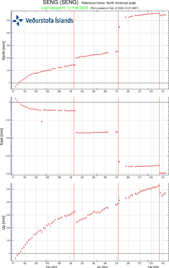
Time series from the GPS station Svartsengi (SENG) since 11th of November 2023 in the north, east and vertical directions (top, middle and bottom images, respectively). The bottom time series show land uplift in millimetres and yesterday's datapoint (11th of February) is shown with a green dot. The red vertical lines are timings of the last three eruptions (18th of December 2023, 14th of January 2024 and 8th of February 2024).
Since noon of 8. February, seismic activity in the area north of Grindavík has been minor, about 50 small earthquakes have been detected, all of which were around or less than M1.0. A small seismic swarm has been ongoing in the western parts of Mt. Fagradalsfjall with about 100 earthquakes detected, mostly M1 events or smaller. Minor swarms in the Fagradalsfjall area have occurred frequent for the past weeks, the depth of the earthquakes is at around 6-8 km.
Updated 9. February at 15:30 UTC
No eruptive activity was observed in a drone-flight over the eruptive site carried out at noon today (9 February) by the Special Unit of the National Police Commissioner. This suggests that the eruption is ending. Volcanic tremor is no longer being detected on seismic sensors.
IMO has updated the hazard
assessment according to the development of the eruptive activity. Changes have
been made to the hazard assessment for some hazards within zones. Hazards due
to opening of volcanic fissures has decreased, but hazards due to gas pollution
are still considered to be likely by the lava flow front. Hazards due to lava
flow is still in place, as lava lobes can burst out from the lava flow front.
Hazards due to sinkholes and fault movements are still considered high in Zone
4 (Grindavík).

(Click on the map to see it larger)
The hazard assessment map is valid until 15:00 on Monday, 12 February, unless changes in activity calls for a re-evaluation.
Updated 9. February at 13:00 UTC
Volcanic tremor has significantly decreased since yesterday (8th of February). The decrease was detected shortly after noon yesterday alongside decreased eruptive activity on the volcanic fissure and activity became more confined in separate craters. Temporary increases of the volcanic tremor were noted last evening, which coincided with increased volcanic activity in the craters. During the night, the activity decreased further and between 7 and 8 this morning, two eruptive craters were active. For the past hours no lava fountaining has been observed on web-cameras but activity within the craters might still be ongoing.
Satellite radar image taken at 14:56 yesterday shows surface subsidence of 10 cm in Svartsengi area, north-west of mt. Þorbjörn, when magma flowed from there towards Sundhnúkur crater row. Model calculations based on these data suggest that about 10 million m3 of magma has flowed from the magma reservoir beneath Svartsengi towards the eruption site at Sundhnúkur crater row.
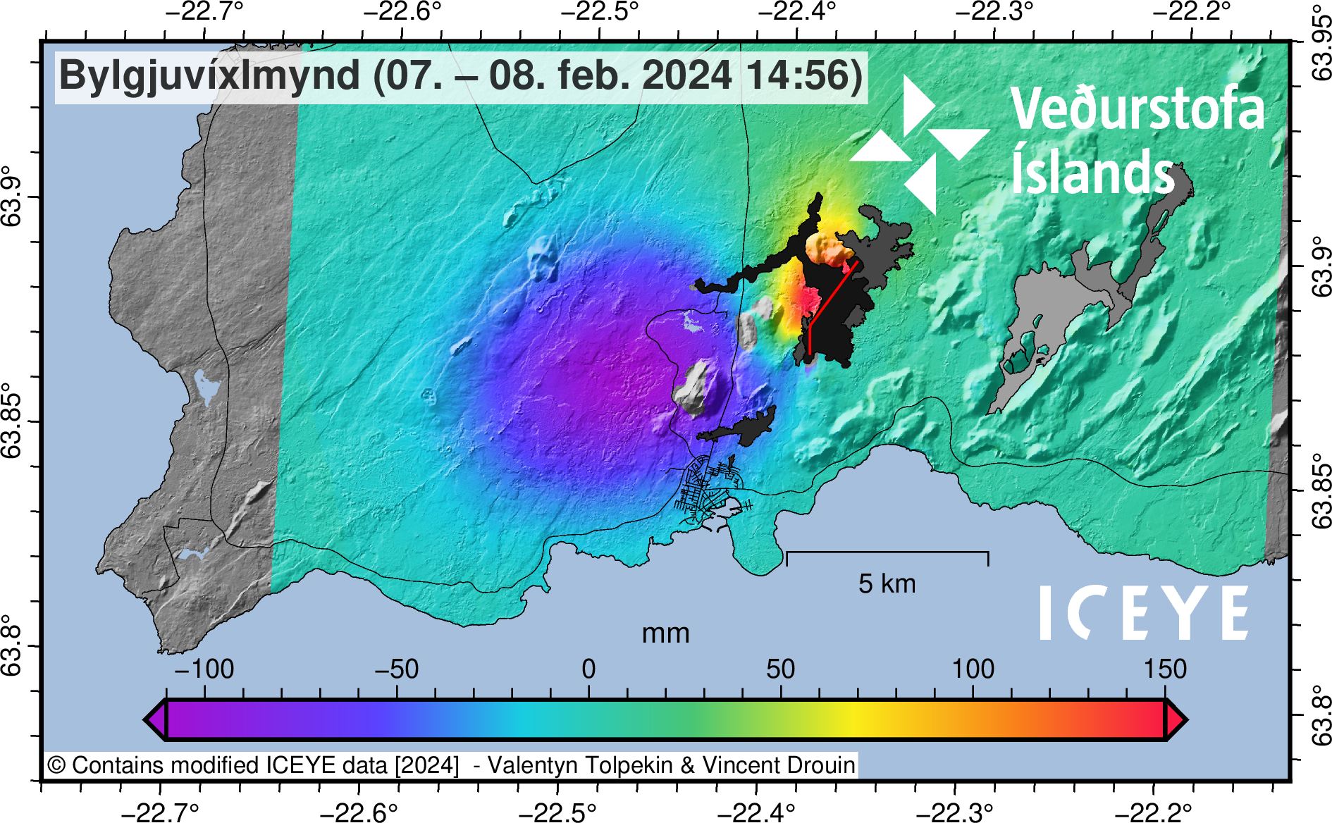
(Click on the Insar Satellite Image to make it larger)
Seismic activity at the eruptive site has been minor during the past 24 hours. About 40 earthquakes have been detected there, all around or smaller than M1.
Volume estimates of the erupted lava from the start of the eruption at 6:02 until 13:00 yesterday (8th of February) is about 15 million m3, which corresponds to an average extrusion rate of 600 m3/s during the first seven hours (data provided by Icelandic Institute of Natural History and Landmælingar Íslands).
Although the eruption has significantly decreased it is still too early to declare if it has come to an end. IMO maintains a 24-hour watch and keeps a close eye on the area. An updated hazard assessment will be published later today.
Updated 8. February at 17:15 UTC
The vigor of the eruption continues to decrease. The eruptive activity is currently on two or three locations on the eruptive fissure. The explosive activity which began between 13 and 14 o‘clock is now mostly over, but minor convective clouds rise from some parts the fissure.
Synchronously with the decreasing vigor of the
eruption, the deformation signals detected at the dyke area diminished, indicating
that magma is no longer ascending under as much pressure as before. Soon after
the onset of the eruption, seismic activity decreased significantly and has
remained minor thus far. About 20 small earthquakes have been detected over the
dyke since 08:00 this morning.
The map shows outlines of the lava flow as it was seen on a satellite image taken at 12:31 today (Thursday 8th- of February). The satellite image shows that lava flowed furthest about 4.5 km to the west from the eruptive site. For comparison, the lava flow field which formed in the eruption on the 18th of December 2023 is also shown on the map. Today ‘s lava flows partly over the lava flow formed in December 2023.
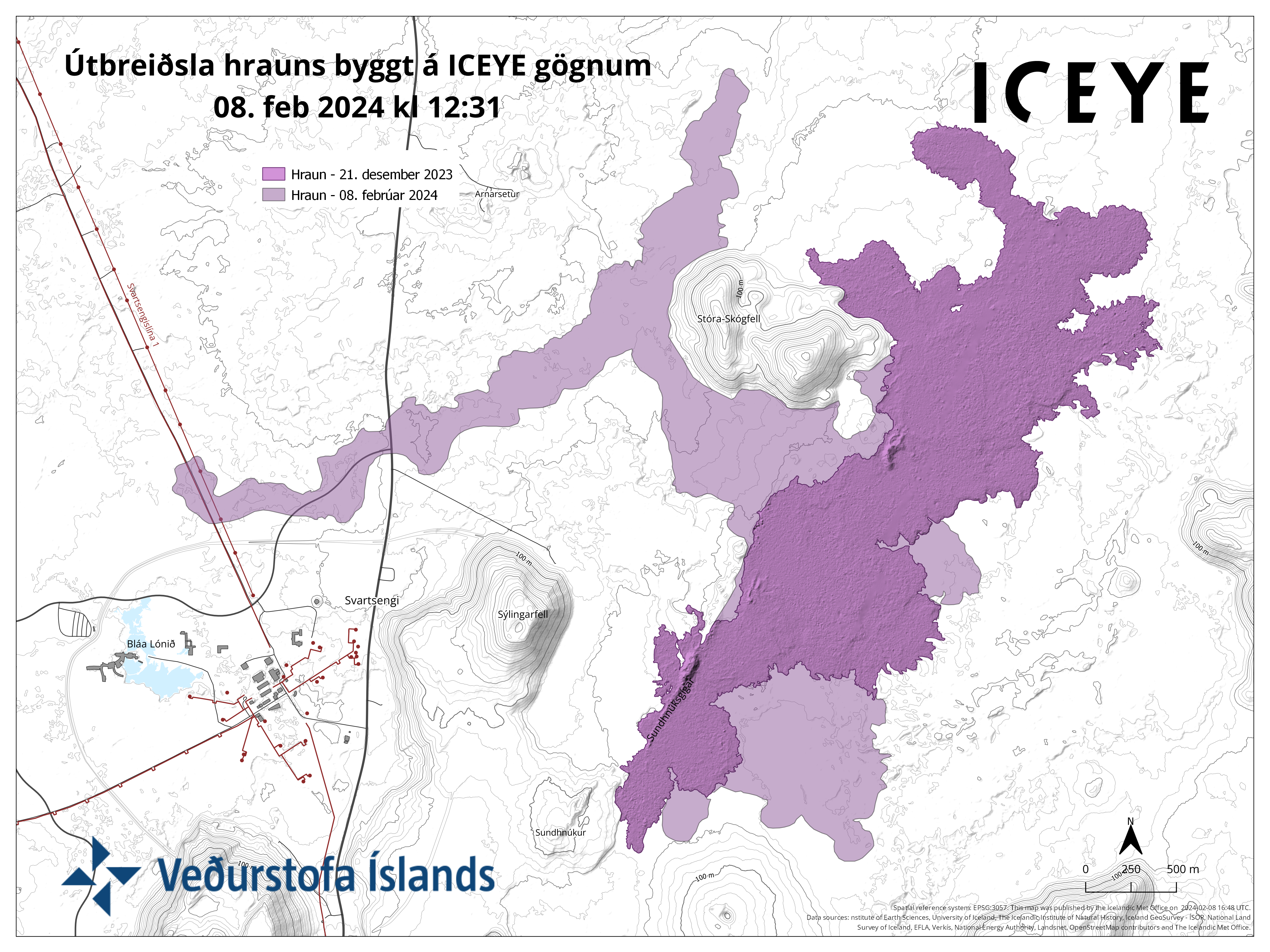
(Click on the map to make it larger)
IMO has updated the hazard assessment map considering the process of the eruptive activity. Changes have been made to the hazard assessment for some hazards within zones. However, these changes do not influence the overall hazard assessment for the zones. The new lava flow field has also been added to the map. The hazard assessment map is valid until 19:00 tomorrow, Friday 9th of February 2024, unless development in activity calls for a re-evaluation.
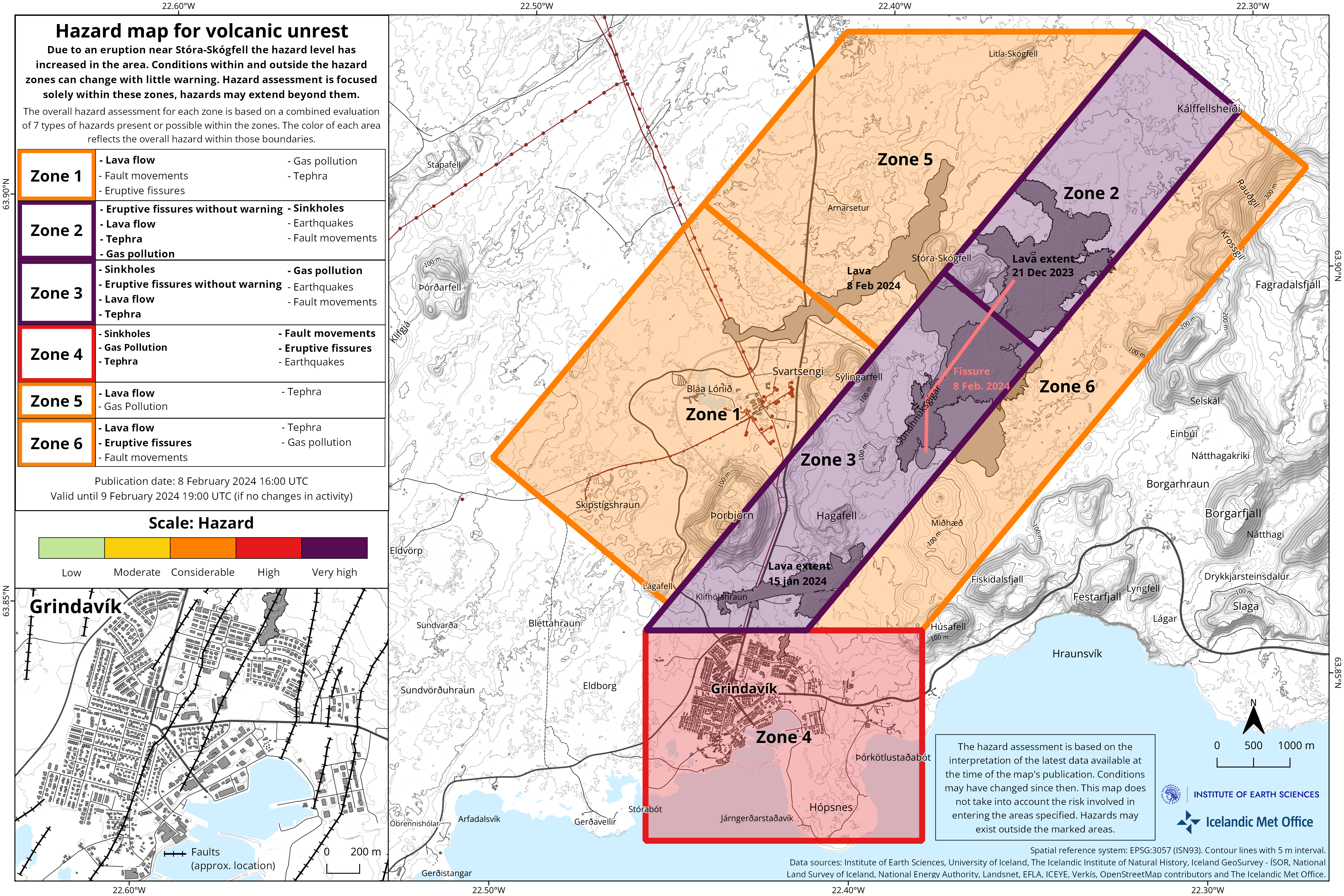
(Click on the map to make it larger)
Updated 8. February at 14:25 UTC
The vigor of the eruption is decreasing. The activity is now mainly on 3 locations on the eruptive fissure which opened this morning. This is not unlike the process observed in the eruption 18th of December 2023, when the activity was confined to a few craters few hours after the onset of the eruption.
A conspicuous,
dark plume rises from one part of the eruptive fissure. This is likely due to
magma interaction with groundwater which results in a slight explosive activity
where white plume of steam mixes with dark volcanic plume.
It seems that tephra does not travel far from the eruptive fissure at the moment. The volcanic plume is dispersed towards south-west.
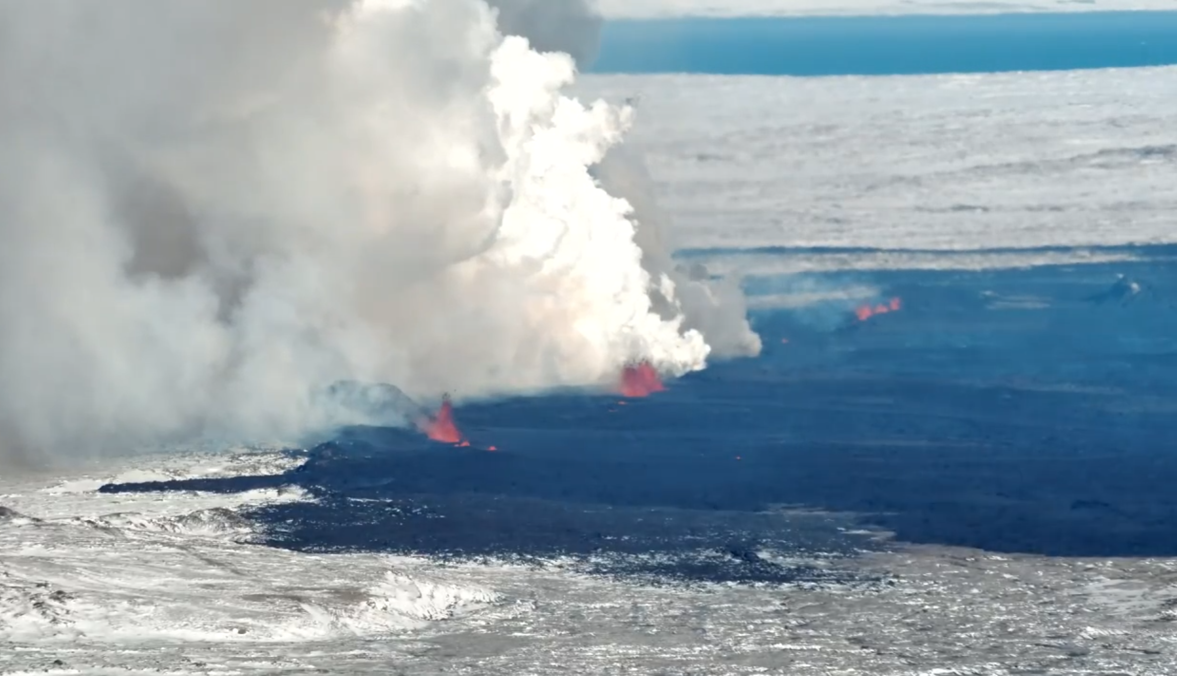
Photo taken towards north-west. (Photo: Special Unit of the National Police Commissioner).
Updated 8. February at 12:20 UTC
Geodetic data suggest that deformation has decreased significantly in the dyke area. Therefore, probability of new eruptive fissure openings has decreased.
IMO has received notifications of tephra fall in Grindavík.
 Tephra is frothy and
vesicular material which forms when splashes of lava cool quickly in the air in
the lava fountaining activity. This process took place when an eruptive fissure
opened this morning (8th of February 2024). Due to the tephras‘ vesicularity
and lightness it can be transported far within the volcanic plume with wind. It falls in Grindavík now, 3-5 km from the source
of formation due to the height of the lava fountains, north-easterly wind-direction,
thermal upwelling from the lava and low air temperature.
Tephra is frothy and
vesicular material which forms when splashes of lava cool quickly in the air in
the lava fountaining activity. This process took place when an eruptive fissure
opened this morning (8th of February 2024). Due to the tephras‘ vesicularity
and lightness it can be transported far within the volcanic plume with wind. It falls in Grindavík now, 3-5 km from the source
of formation due to the height of the lava fountains, north-easterly wind-direction,
thermal upwelling from the lava and low air temperature.
Tephra is a synonym for all airborne, solid, eruptive materials,
regardless of size an type. Tephra formation is well known in Iceland, such as in
the explosive eruptions in Grímsvötn 2011 and 2004, and Eyjafjallajökull 2010. In
explosive eruptions, the lava is more fragmented in the air an produces finer-grained
tephra but tephra can also be produced in effusive eruptions such as is now ongoing
on the Reykjanes peninsula. In effusive eruptions, the majority of tephra is
deposited close to the vent and thus is not well detectable outside of the lava
flow field. In May 2021, when lava fountaining was most active in the eruption
in Fagradalsfjall, large pieces of tephra (up to 10 cm in diameter) fell at
about 1 km distance from the eruptive source.
Tephra is sharp as glass and thus should be carefully
handled. Windscreen wipers should not be used to remove tephra from vehicles as
it will scratch the glass. Tephra should rather be blown or washed off with
water of windows and similar surfaces.
Gas dispersion
Weather forecast for gasdispersion from the volcanic site is north-easterly winds, 4-8 m/s today (Thursday), thus gas is dispersed towards south-west. Decreasing wind speed tonight which can cause gas concentrations to build up at the volcanic site. Easterly and south-easterly winds, 5-10 m/s after noon tomorrow (Friday), causing gas to be dispersed to the west and north-west, towards Keflavík.
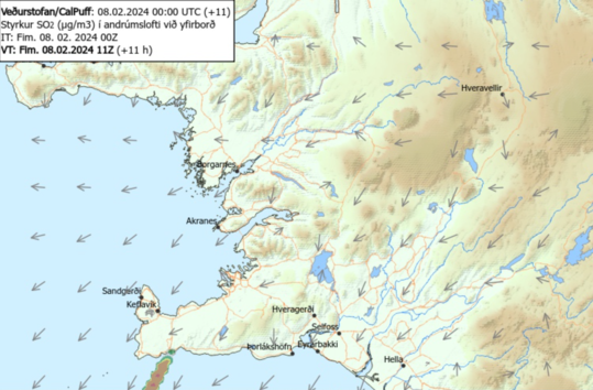
Updated 8. February at 11:40 UTC
The Icelandic Met Office has updated the hazard map for the area. The hazard level has increased in all areas due to the eruption.

Updated 8 February at 7:50 UTC
At 5:30 this morning an intense seismic activity started north-east of mt. Sýlingarfell. Around 30 minutes later, a volcanic eruption started at the site.
The eruptive fissure lengthened both towards north and south during the first minutes.
The
first images from the Icelandic Coast Guard's surveillance flight suggest that the eruption takes place at a
similar location as the eruption on the 18th of December 2023. The eruptive fissure
is approximately 3 km long, from mt. Sundhnúkur in the south and stretches towards
the eastern part of mt. Stóra-Skógfell. Lava flows mostly towards west at the
moment and the flow seems to be slightly less than at the start of the 18th of
December eruption.
The lava
fountains reach about 50-80 m height and the volcanic plume rises about 3 km above
the eruptive fissure.
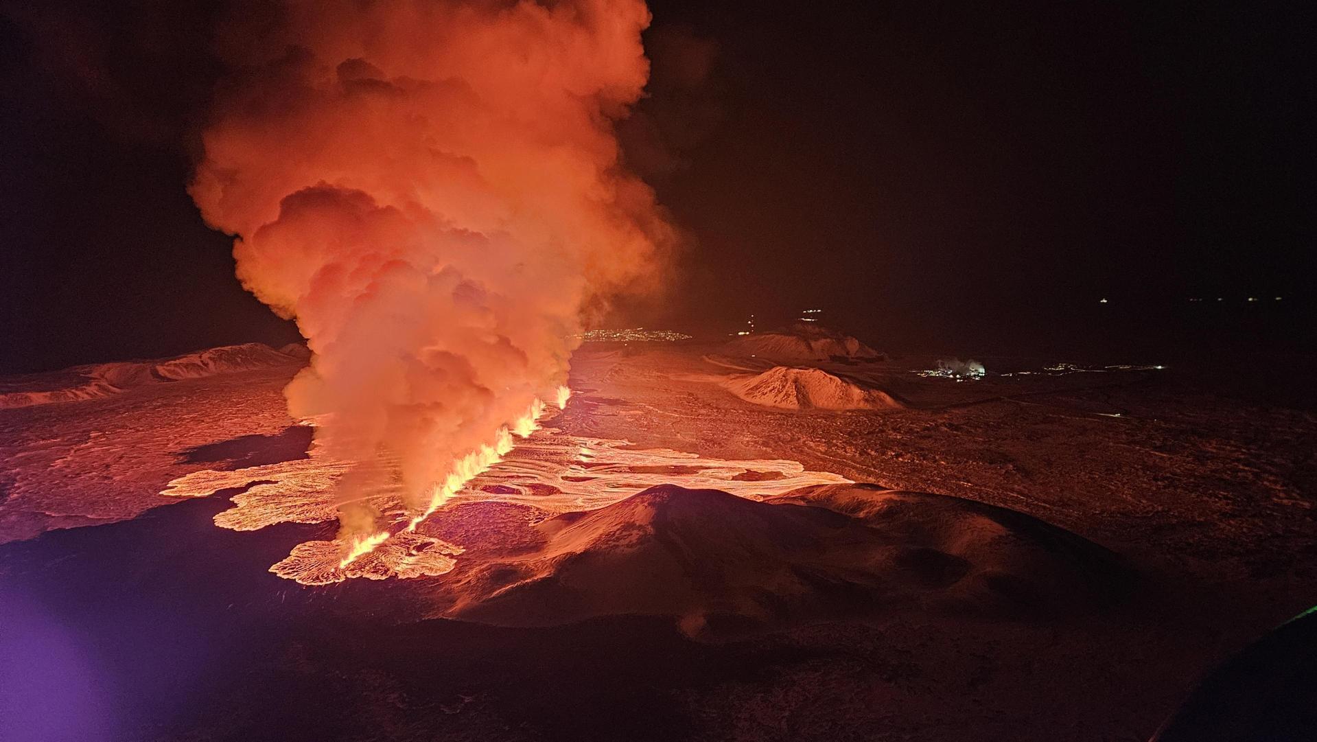
Updated 5 February 16:00 UTC
Ongoing magma accumulation beneath the Svartsengi-Þorbjörn area continues, even though the rate of inflation has decreased slightly in recent days. Similar processes were observed before the previous dyke intrusions and eruptions north of Grindavík in January 2024 and December 2023. According to updated geodetic models based on satellite and GNSS data covering the interval from 16 January to 5 February, the volume of magma recharge to the Svartsengi reservoir is now estimated at about 9 million m3. From geodetic modelling of the January 2024 intrusion and eruption, it is estimated that approximately 9 to 13 million cubic meters of magma flowed from the Svartsengi magma reservoir, feeding the eruption that began near Hagafell on 14 January. Therefore, the estimated volume of magma recharge has now reached the lower limit of the amount believed to have been tapped in January. Consequently, there is an increased likelihood of a new magmatic dyke intrusion and ensuing volcanic eruption in the coming days to weeks.
Since last Friday, nearly 200 earthquakes have been measured in the area north of Grindavík, most of them around or below magnitude 1 at depth of 3-4 km. The largest earthquake occurred on the morning of Sunday, 4 February, near Sundhnúkur, and was a M2.2 at a depth of approximately 6 km.
The IMO continues to closely monitor the area, and the current hazard assessment map remains valid until 3:00 PM on 8 February, if there are no changes in activity.
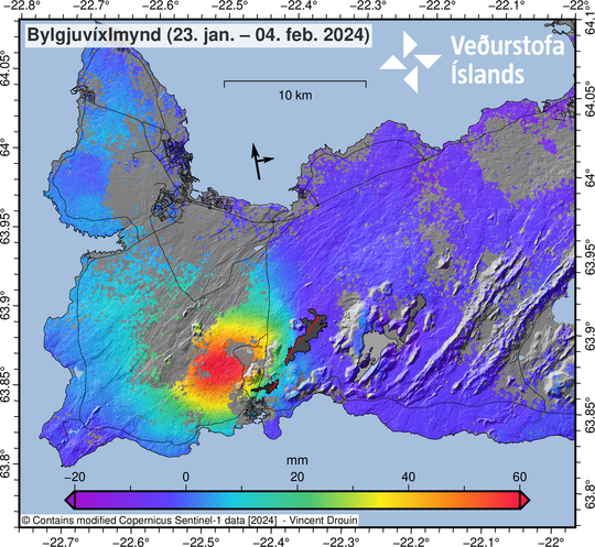
Updated 1 February 17:00 UTC
Models based on GPS data, reviewed this morning (1 February) by scientists from the Icelandic Meteorological Office and the University of Iceland, indicate that approximately 6.5 million cubic meters of magma has accumulated beneath the Svartsengi region. According to this assessment, magma will soon reach the same volume as drained during the January 2024 eruption. Therefore, the timescale for the next eruption could be within two weeks or possibly days. This means that the likelihood of a magma intrusion, and a volcanic eruption, have increased.
There is no absolute certainty that the warning time ahead of the next intrusion or eruption will be the same as 14 January, which was about a five-hours' notice from the beginning of the earthquake swarm until the eruption began just south of Hagafell. The warning period for the eruption between Stóra-Skógfell and Sundhnúkur on 18 December last year was about 90 minutes, and that eruption occurred approximately at the mid-point of the (now solidified) magma intrusion beneath the Sundhnúksgígar crater row. With repeated lateral magma intrusions, it is likely that the pathway for magma propagation to the surface will be easier, resulting in less seismicity. However, rapid movements of magma are always accompanied by increased micro-seismicity. We assess that the minimum warning time would be one-hour ahead of a volcanic eruption, and that the most likely pathway would be along the fissures from the magma intrusion on 10 November last year.
Seismic activity has been similar over the past week. Nearly 200 earthquakes have been measured in the area between Stóra-Skógfell and south of Hagafell in the past seven days. Most of these earthquakes were minor, under 1.0 in magnitude, at a depth of 2 to 5 km. The largest earthquake registered magnitude 1.8, and it was located about a kilometre south of Hagafell.
The Icelandic Meteorological Office has issued an updated hazard assessment map. The main changes are that zone 3 (Sýlingarfell – Hagafell) has been upgraded to red (high hazard), and zones 2 and 6 have been upgraded to amber (considerable hazard). Grindavík (zone 4) remains unchanged at a considerable level of hazard.

The overall assessment for each zone is based on a combined evaluation of seven types of hazards that could occur within individual zones. The list on the map shows hazards within the zones that are rated as "considerable", "high," or "very high". Hazards rated as "high" or "very high" are highlighted in bold.

It should be noted that
although the overall hazard assessment for Grindavík remains the same as last
week, the lava-flow hazard is now assessed as high. The hazard of sinkholes
opening over fissures within Grindavík is still rated as very high.
Updated 25 January 17:30 UTC
Inflation continues at Svartsengi. Over the past few days, the land has been rising at a rate of approximately 8 mm per day, slightly exceeding the recorded rate of uplift before the eruption on January 14th.
At this point, it is challenging to determine exactly how much magma has accumulated beneath Svartsengi since the eruption ended on January 16th. Most likely, the timeframe required to reach the same volume of magma as before the last eruption will be on the order of weeks, not days. Computational models are being refined to obtain a clearer assessment of the status of magma accumulation.
Low levels of seismic activity persist and are mostly concentrated around Hagafell. The current seismic activity aligns with that observed in the area following the previous eruption.
The Icelandic Meteorological Office has issued an updated hazard assessment map. The main changes include reducing the overall hazard level for Grindavík to orange (significant hazard).
It should be noted that, although the overall hazard level for Grindavík has been reduced by one level, the hazard associated with fissures remains very high. The current hazard is now referred to as "subsidence into a fissure," describing the danger that may be present where fissures are hidden beneath unstable surfaces that could collapse and develop sinkholes.
The hazard assessment related to fissure development within Grindavík has decreased. Evaluations are underway to determine if there is a danger of existing fissures expanding or new fissures forming. GPS data have exhibited very little movement within Grindavík the past few days, reducing the assessed hazard compared to before. The hazard due to sinkholes overlying fissures is now considered significant.

(Click on the picture to see it larger). Increased hazard in the area due to the eruption near Hagafell on January 16th and land uplift near Svartsengi. Conditions within and outside the hazard areas can change with little warning. Hazard assessment is focused solely within these areas, but the danger may extend beyond them. The overall hazard assessment for each area is based on a combined evaluation of 7 types of hazards present or possible within the regions. The color of each area reflects the overall hazard within those boundaries.
Updated 19 January 16:30 UTC
Clear signals of a continued land uplift are still being detected beneath Svartsengi. It is yet too early to assert whether the rate of the land uplift has increased since prior to the eruption on January 14. First measurements suggest that is the case, but as has previously been written measurements can fluctuate from one day to the next and a longer timeline of measurement is needed to be able to interpret the long-term development of the land uplift.
Seismic activity continues to decrease in the area of the magma dyke and deformation signals seen on GPS devices suggest significant slow down of ground movement compared to previous days. This information suggest that magma is no longer flowing into the dyke and the eruption has ended.
GPS measurements also show small deformation within Grindavík. There is still high danger of ground collapse into fissures within the town and thus important to map new fissures and changes to known ones estimated.
The Icelandic Meteorological Office has updated the hazard assessment due to the volcanic and seismic activity. Hazard level has been decreased in all zones.
An overall hazard assessment for zone 1, Svartsengi, is now down to yellow (moderate hazard).
An overall hazard assessment for zone 4, Grindavík, is now down to red (high hazard). Note that the colour of zones represents the overall hazard within those zones. A hazard which is rated greater within a zone is written in bold letters in the list of hazards on the map.
The the hazard assessmept map takes effect at 15:00 today, Friday January 19 and is valid until Thursday, January 25, at 15:00, unless there are significant developments.

Updated 18 January 15:30 UTC
As reported in the news yesterday, clear signs of land rise persist beneath Svartsengi, but it is still too early to determine the rate of the uplift due to the recent volcanic activity in the area. GNSS measurements are being evaluated to provide a comprehensive assessment of the situation. However, it appears that the deformation remains similar to that observed after the volcanic eruption on December 18.
Around 200 earthquakes have been recorded near the magma conduit since yesterday, with the largest measuring 1.4 in magnitude. Since midnight, approximately 70 small earthquakes have occurred, which is fewer than measured the day before. The weather has impacted the number of earthquakes detected in recent days, but the number of earthquakes seems to have decreased overall.
A significant risk remains in Grindavík due to fissures and the potential for ground collapse into them.
Updated 17 January 18:00 UTCMagma accumulation continues under Svartsengi. It is too early to assert the rate of the land uplift shortly after the volcanic eruption. Experts will continue to assess data from GNSS stations in the area to get an overall assessment of the situation. One of the meters, which was located north of Grindavík, went under lava, but over 20 GNSS stations are in the area and are being used.
Seismic activity has been mild over the magma conduit in the last 24 hours. According to computational models, magma lies shallow at the southern end of the conduit, where the land appears to be heavily fractured, making it easier for the magma to reach the surface. Therefore, there is a continued likelihood that new eruptive fissures may open without warning.
There is still danger within Grindavík related to fissures and the potential for ground collapse into them. Significant deformation has occurred in connection with the graben in the eastern part of the town. These movements were mostly along the fissures that formed on November 10 and had already been mapped.
Gas pollution was measured yesterday during work on wells connected to the utility system within Grindavík. The Icelandic Meteorological Office does not monitor localized gas pollution within Grindavík. It needs to be further examined whether or not the gas pollution is related to the magma lying very shallow in the area. It should be noted that dangerous gas pollution is among the issues mentioned in the current hazard assessment for Grindavík.
The IMO has issued an updated hazard assessment map. There are no changes in the overall hazard assessment for the areas compared to what was previously. The map takes effect at 15:00 today and is valid until Friday, January 19, at 15:00, unless there are significant developments.

Updated 16 January 18:00 UTC
Magma continues to accumulate beneath Svartsengi at a rate similar to that observed before the last two eruptions. This was the consensus reached during a consultation meeting of scientists this morning. During the eruption this past Sunday, similar to the December 18 eruption, magma flowed eastward from the accumulation site beneath Svartsengi, creating a magma conduit extending from Stóra-Skógfell southward beneath Grindavík. Computational models support this observation and indicate that the origin of the magma was slightly further west compared to the previous eruption, leading to variations in recent GPS measurements compared to those recorded on December 18.
As a magma conduit forms close to the surface, the Earth's crust is strained, causing the land above the central part of the conduit to subside and form a graben. Additionally, the ground is elevated on either side of it. Computational models reviewed at the consultation meeting show that the GNSS station in Svartsengi is located at the edge of the conduit, where the land rises as the conduit forms. Now, two days after the conduit's formation, the Svartsengi GNSS station is expected to show subsidence if magma accumulation has ceased. However, this is not observed, indicating that magma accumulation continues as before.
The magma conduit generated in the eruption that began on Sunday lies slightly further east than the conduit that extended under Grindavík on November 10. Data collected and processed by the Icelandic Institute of Natural History and the National Land Survey of Iceland reveal that a new graben has formed east of the one that appeared on November 10. The newly formed graben measures approximately 800-1000 meters in width, as shown on the map below. The greatest subsidence within it is approximately 30 cm, but it is worth noting that the region is still experiencing subsidence, and the valley is progressively widening. In comparison, the graben that developed in Grindavík on November 10 had a width of about 2 km, with the most significant subsidence measuring around 1.3 meters.
Inside this recently formed graben, previously mapped fissures that were visible on the surface have expanded, and additional fissures have emerged. Consequently, the risk associated with these fissures and the possibility of ground collapse into them have increased in the eastern section of Grindavík compared to before.
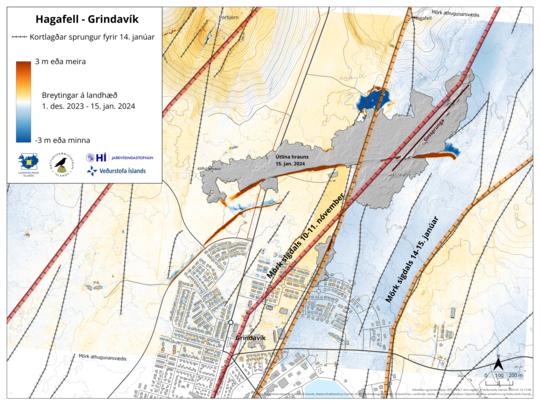
Map showing the location and width of the graben formed on November 10th (“Mörk sigdals 10-11. nóvember”) and the newest graben that recently formed to the east (“Mörk sigdals 14-15. janúar”).
Updated 16 January at 11:45 UTC
There is currently no visible activity within the eruptive fissures, with the most recent lava observed emanating from the northern fissure shortly after 1 am last night. Seismic activity continues to decrease, signifying that the area is stabilizing. Approximately 200 small earthquakes were recorded near the magma conduit since midnight, indicating that magma is still migrating. Most seismic activity is located near Hagafell, close to the first eruptive fissure that opened on Sunday morning. At this point, it is premature to declare that the eruption is over.
GPS sensors continue to detect ground deformation in and around Grindavík, illustrating that the magma conduit beneath Grindavík is still causing expansion in the area. Thermal images from a drone last night show that fissures previously mapped southwest of Grindavík have significantly enlarged. Considerable hazards persist in the area.
Updated 15 January at 16:40 UTC
Based on webcam footage, it is evident that the lava flow has decreased from the eruptive fissures that opened yesterday. Flow from the southern eruptive fissure, which emerged around noon yesterday near the town‘s border, seems to have ceased. The majority of the remaining lava flow is now directed southwest along the protective barriers, and its trajectory seems to have stabilized.
It is difficult to estimate how long this eruption will last. Seismic activity has decreased, and GPS measurements indicate that the rate of deformation in the area has reduced. However, deformation is still detected near the southernmost part of the magma conduit beneath Grindavík.
Measurements indicate that there has been a displacement of up to 1.4 meters in the past 24 hours, distributed across numerous fissures within the town‘s boundaries. Fresh fissures have developed, and existing ones have expanded. It is possible that additional fissures may emerge on the surface in the next few days.
As previously stated, the eruption sites are extremely hazardous, and the possibility of new fissures emerging without warning cannot be dismissed. This was demonstrated by the eruptive fissure that appeared near the border of Grindavík yesterday, which provided no recognizable warning signs on the monitoring equipment.
Today, there is a mild wind from the northeast at the eruption sites, but it will pick up speed later in the day. Therefore, gas pollution is drifting southwest towards the ocean. Tomorrow, the area will experience winds from the north reaching 10-18 m/s, causing the gas to drift south. Refer to the weather service's forecast for gas dispersion details.
The Icelandic Meteorological Office continues to monitor the area and is in direct contact with civil protection and response teams in the region about the progression of the event.
Scientists met this morning for a consultation meeting organized by the Icelandic Meteorological Office. They reviewed the most recent data related to the eruption.Top of Form
In the upcoming days, there will be ongoing measurements and the collection of additional data, followed by analysis. These data are being utilized, among other things, to construct models that enhance comprehension of the pre-eruptive indicators that led up to this event and to evaluate the most likely progression of the eruption. Comparisons are also being made between the December 18 eruption and the eruption that began yesterday to enhance understanding of changes in the area and to evaluate the most likely scenarios going forward.
The Icelandic Meteorological Office has issued an updated hazard assessment map based on the latest data. It remains unchanged from the last update. The map is valid until 19:00 on Wednesday, January 17, unless new developments arise.


Map depicting the extent of the lava based on measurements conducted by the Icelandic Institute of Natural History and the University of Iceland's Institute of Earth Sciences. Surveys were conducted twice yesterday. The dark purple shape shows the extent of the lava as of 1:50 pm on January 14, while the light purple shape shows the extent as of 4:15 pm, almost 2.5 hours later. The eruptive fissures are denoted by red lines, while the barriers constructed to prevent lava from reaching Grindavík are represented by orange dotted lines

Map exhibiting the thickness of the lava flow based on measurements at 13:50 yesterday.
Updated 14 January at 15:30 UTC
The eruption near Hagafell-Grindavík has maintained the same strength for the past hour or so.
Seismic measurements show that at the beginning of the unrest this morning (~2:30 am), the magma filled dike intrusion initially moved from the SE edge of Stóra-Skógfell and then continued southwest to the southern end of Grindavík. At 5:30 am seismicity had reached the northern end of Grindavík and both seismicity and deformation measurements indicate the dike has since propagated beneath Grindavík town. A new eruptive fissure opened at 12:10 this afternoon, just north of the town. Lava flows extruded from this fissure have now entered the town.
Due to the dike propagation, existing faults and fractures were reactivated and likely new fractures formed within Grindavík.
Gas distribution
The Icelandic Meteorological Office's weather forecast for gas distribution from the eruption at Hagafell indicates that the direction is north and northeast, with a speed of 3-8 m/s, and the weather is dry and bright today. It will be cloudy at times with minor snowfall late tonight and tomorrow morning. It will clear up in the afternoon tomorrow. Pollution from the eruption is spreading south and southwest.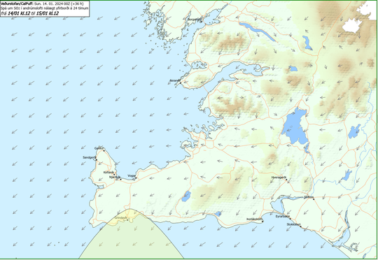
New Hazard Map released
The Icelandic Meteorological Office has updated the hazard assessment map in light of the interpretation of the latest data.
The risk has increased in all areas. The hazard assessment map is valid until 19:00, Monday, January 15, unless otherwise stated.

Updated 14 January at 8:20
An eruption started at 7:57 UTC
The fissure opening is southeast of Hagafell mountain.
The southern most part of the fissure is about 900 m from the town of Grindavík.
The opening is south of lava flow deflection barriers that are being built north of Grindavík. Lava is now flowing towards the town.
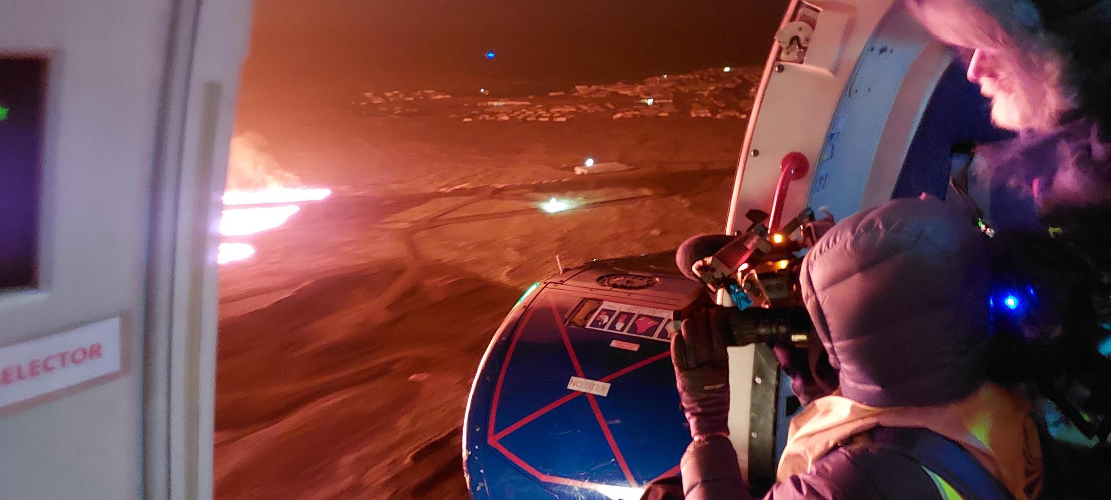 A picture taken on-board the Coast Guard flight. Fissure opening can be seen with the lights in Grindavík in the distance.
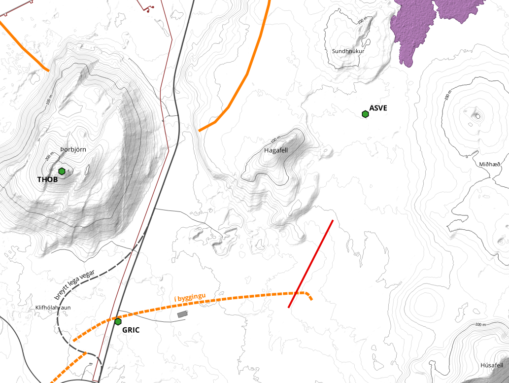
A map showing the fissure opening marked with a red line.
Updated 14 January at 06:15 UTC
At around 03:00 UTC today, an intense series of earthquakes began at the Sundhnúksgígar crater row.
At the time of publication, over 200 earthquakes have been measured in the area, and the seismicity has moved towards the town of Grindavík.
So far, the largest recorded earthquake is 3.5 in magnitude, and it was measured at 04:07 UTC at Hagafell.
Both real-time GPS measurements and borehole pressure readings (from HS Orka) show major changes since the onset of today's earthquake activity. These observations, in addition to the ongoing seismicity, confirm that magma is moving within the region.
Our assessment is that the possibility of an eruption is high, and that it could occur imminently.
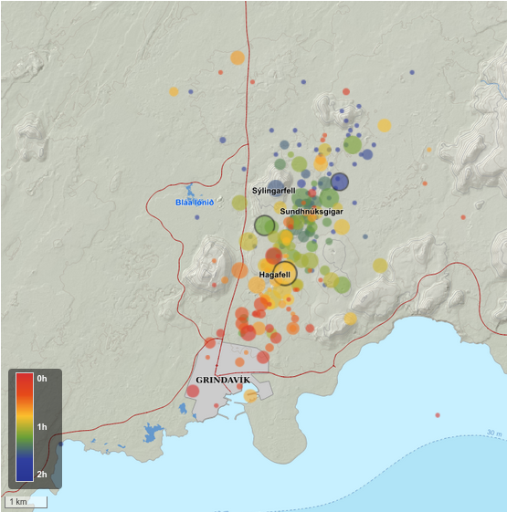
A map showing the latest earthquake activity.
Updated 12 January at 17:45 UTC
The Icelandic Meteorological Office has updated the hazard assessment map for the Grindavík – Svartsengi region due to the ongoing unrest on the Reykjanes Peninsula. As before, the map shows an assessment of existing hazards that could occur with little warning within the specified regions. Note that the assessment applies only for hazards within the defined areas, although hazards are possible beyond the confines of the assessed regions.
In terms of colour-coding, the overall assessment for the six zones remains unchanged from the previous map. However, there is a change in the hazard assessment associated with fissures within Grindavík (zone 4). The hazards associated with sudden opening of mapped and unknown fissures within Grindavík is now deemed higher. It should be noted that the hazards associated with fissures is limited to known areas within the municipal boundaries.
Unless otherwise stated, the map is valid until Tuesday, 16 January 2024.

Updated 9 January at 13:00 UTC
Seismic activity continues to exhibit a pattern similar to that of recent days. The earthquake activity remains relatively low, primarily centered between Hagafell and Stóra Skógfell, where the center of the intrusion is situated. Additionally, there is ongoing seismic activity in Fagradalsfjall, persisting since December 18th.
Land uplift is still being measured in the Svartsengi area, exhibiting a relatively stable trend since the eruption on December 18th. The accompanying image, marked with red dots representing data from the GPS station SENG in Svartsengi, illustrates this trajectory The recent rate of uplift is approximately 5 mm per day, resulting in a current elevation that is about 5 cm higher than before the dike intrusion on November 10th and December 18th last year.
Calculations from models relying on deformation measurements (GPS and satellite images) indicate that the amount of magma accumulated in the reservoir beneath Svartsengi has reached a level comparable to the volume that led to the formation of the magma conduit and the subsequent eruption on December 18th last year. This suggests that there is an increased risk of an eruption in the coming days.
The Icelandic Meteorological Office issued an updated hazard map on January 5th, and it will be reassessed on January 12th.
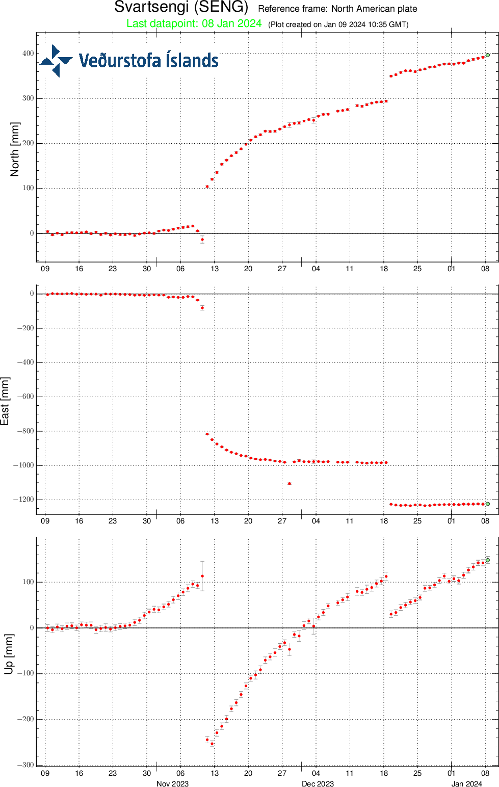
Relative measurements from the GPS station SENG in Svartsengi from the beginning of October 2023 to present, displaying north, east, and vertical components (top, middle, bottom). The bottom curve shows land uplift in millimeters, with today's measurement indicated by a green dot.
Updated 5 January at 17:40 UTC
A new hazard map has been issued by IMO. The map reflects a hazard-based appraisal of the Grindavík – Svartsengi region, made on 5 January 2024. The hazard assessment is based on the latest monitoring data, including seismic activity and ground deformation, as well as geodetic modelling results. The assessment also takes into consideration the likelihood of volcanic hazards in each of the six zones, as shown on the map.
In today's assessment, the main change affects the Svartsengi region (zone 1), which is now considered to be at a moderate hazard level, reflecting a decrease from the previous version of the hazard map. The justification for this change is that the hazard rating due to the formation of major surface fractures has decreased as no new major fractures have formed lately. Additionally, the latest geophysical observations, together with our scientific consensus, makes Sundhnúksgígar the prime location for an eruption.
In the meantime, IMO continues to monitor the area and any changes will be communicated directly to civil protection via the usual communication channels.
Updated 5 January at 14:30 UTC
The rate of land uplift near Svartsengi continues to decrease. Experts gathered at the Meteorological Office this morning confirmed this through an analysis of GPS data. As previously reported, this signals a rise in magma pressure, increasing the likelihood of a new dike intrusion and potential eruption. However, it cannot be ruled out that this may alternatively suggest a decrease in magma inflow.
Approximately 490 earthquakes have occurred near the magma conduit since Tuesday, January 2. Among these, 14 had magnitudes exceeding 1.0, with the largest measuring 1.8 north of Hagafell. On Wednesday, January 3, a magnitude 4.3 earthquake occurred near Trölladyngja, followed shortly by a magnitude 3.5 earthquake and numerous aftershocks; about 900 earthquakes have been measured in the area.
The seismic activity near Trölladyngja on January 3 occurred along a recognized fault line where larger earthquakes have previously happened multiple times. There is no indication that these earthquakes are directly linked to magma movements. Nevertheless, the notable changes in the landscape associated with volcanic activity in Fagradalsfjall, the land uplift near Svartsengi, the magma conduit near Sundhnúk on November 10, and the eruption on December 18 have been measured across western Reykjanes and influence seismic activity throughout the entire region.
According to their evaluation, scientists conclude that in the event magma reaches the surface, the most probable site for a subsequent eruption would again be Sundhnúksgígaröðinni, situated between Stóra-Skógfell and Hagafell. However, it is important to remember that dike intrusions do not always culminate in an eruption, as evidenced by the activity at Fagradalsfjall and also during the Krafla fires.
Updated 3 January at 12:30 UTC
At 10:50 AM, an earthquake of magnitude 4.5 occurred near Trölladyngja, followed shortly by another earthquake measuring 3.9 at 10:54 AM and a series of aftershocks. The earthquakes occurred at a depth of approximately 5 km and were likely triggered in response to stress released from earth movement elsewhere on the Reykjanes Peninsula. These earthquakes were widely felt in the southwest region of Iceland.
The location of the earthquakes is about 20 km NNE of Svartsengi, where land rise due to magma accumulation is ongoing.
The accompanying image shows the location of the earthquake that occurred at 10:50 AM and its impact area.
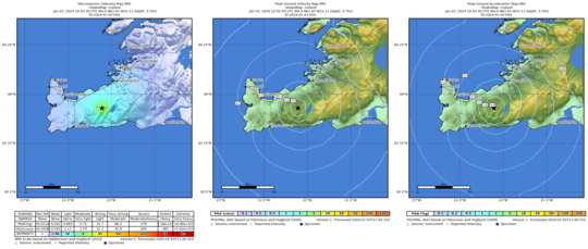
Updated 2 January at 14:00 UTC
The rate of ground displacement at Svartsengi is decreasing. Experts gathered at the Meteorological Office this morning confirmed this through an analysis of GPS data.
The deceleration of inflation is an indication that magma pressure is rising, increasing the chances of new dike intrusion and also volcanic eruption. This is a similar change in ground displacement that was observed at the end of the day on December 15, which culminated in an eruption three days later. However, it is difficult to assert whether this pattern will repeat.
The first signs of an impending volcanic eruption are a sudden increase in seismic activity, and such signs were observed shortly before the eruption began on December 18.
In recent days, seismic activity in the area has been relatively consistant, with around 200 earthquakes recorded per day. Most of the earthquakes measure below magnitude 1.0, but around 30 earthquakes with magnitudes exceeding 1.0 have been recorded since December 29, with the largest being a magnitude 2.1 located in the northern part of Grindavík.
Continued scientific assessment indicates that, should an eruption occur, the Sundhnúkur crater row, between Stóra-Skógafell and Hagafell, is the most probable location for an eruption. However, it is important to note that magma migration does not always result in an eruption, as demonstrated by the activity at Fagradalsfjall and in the Krafla Fires.
The hazard assessment map issued by the Meteorological Office onDecember 29 remains unchanged and is valid until January 5.
Seismic activity continues to be measured west of Fagradalsfjall, where around 100 small earthquakes have been recorded since December 29. Further analysis of the monitoring data will soon be conducted to obtain a clearer picture of the situation at Fagradalsfjall.
Updated 29 December at 15:15 UTC
The ground continues to inflate at Svartsengi. At the GPS station Svartsengi (SENG), the land has now reached a similar height as measured just before the eruption on 18 December. The rate of uplift since 18 December has remained constant, which is different from the situation before the last eruption, where uplift slowed in the days before the eruption. However, it is difficult to assert that the uplift will slow down before the next eruption, though this has been the case in eruptions on the Reykjanes Peninsula in recent years, and it was also noted during the Krafla Fires. Uncertainty remains about how much magma pressure needs to build up before magma starts moving towards the surface.
The current uplift is not accompanied by as much seismic activity as before. The reason for this is that significant stress in the area was released during the events on 10 November and 18 December. Therefore, considerably more magma needs to accumulate before seismic activity increases from its current level. Before the last eruption, there were several earthquakes over magnitude 3 and one over magnitude 4. Similar seismic activity can be expected in connection with the next magma intrusion.
As magma accumulation continues under Svartsengi, the likelihood of another magma intrusion and an eruption increases with each passing day. It is most likely that the next eruption will occur in the Sundhnúkur, between Stóra-Skógfell and Hagafell. It is important to note that magma intrusions do not always lead to an eruption, as shown by the activity at Fagradalsfjall and in the Krafla Fires.
The Icelandic Meteorological Office has issued an updated hazard map, based on the joint interpretation of data at a status meeting held today, 29 December. The overall assessment of hazard levels within the areas remains unchanged from the last update. However, changes have been made to the list of potential hazards within area 4, Grindavík, where risks due to possible lava flow and gas pollution have been added. The changes are due to increased chances of an eruption north of Grindavík. This hazard map will be reviewed on 5 January 2024.
In the meantime, IMO continues to monitor the area and any changes will be communicated directly to civil protection via the usual communication channels.

Updated 27 December at 14:20 UTC
Since 22 December, around 730 earthquakes have been recorded in the vicinity of the magma intrusion, of which 40 had a magnitude above M1. The largest earthquake over this period had a magnitude of 2.1 on 26 December, north of Hagafell. Most of the earthquakes are occurring at a depth of 4 km. Additionally, between 22 December and today, around 140 earthquakes have been located on the western side of Fagradalsfjall. Five of these earthquakes were above M1 in size and the overall depth range was 4 to 7 km.
Ground deformation continues in the Svartsengi region, and the rate of deformation is now similar to before the eruption on 18 December 2023. This means that magma continues to accumulate under Svartsengi. Therefore, it is increasingly likely that another magma intrusion will occur, possibility leading to a second volcanic eruption. Geodetic modelling results indicate that over 10 million m3 of magma were sourced from beneath Svartsengi to feed the intrusion that formed on 18 December, which led to the eruption. Based on the ongoing uplift rate, it will take one to two weeks for the same amount of magma to accumulate again underneath Svartsengi. There is still significant uncertainty on when the built-up in magma pressure will be sufficient to trigger the next magma intrusion.
It should be noted that the original magma intrusion, which formed on 10 November, extended 15 km from Kálfafellsheiði in the north to the southwest of Grindavík, just offshore. This means that magma propagated at depth beneath the entire area, including the town of Grindavík. However, the most likely source area for the next eruption is between Stóra-Skógfell and Hagafell. Based on insights from the December 2023 eruption, the likelihood for the next event increases day by day.
The hazard assessment map issued on 22 December 2023 remains valid. Assuming an unchanged situation, a new map will be issued on 29 December.
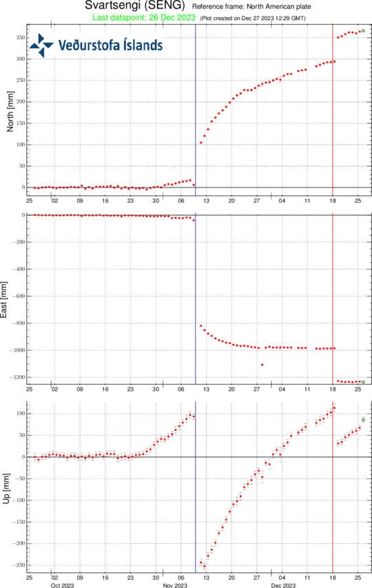
Time-series of continuous GPS solutions from station Svartsengi (SENG). The graph shows ground displacements in three components over the past 90 days. From bottom to top they are: up, east, and north, all measured in millimetres. The blue, vertical line shows the timing of the 10 November magma intrusion, and the red line the volcanic eruption on 18 December 2023. Each data point represents a 24-hour solution, and the vertical component shows clearly the ongoing ground uplift at Svartsengi.
Updated 22 December at 17:00 UTC
As announced yesterday, the fissure eruption at Sundhnúksgígar has ended. This indicates a temporary cessation of eruptive activity. In the last 24 hours, nearly 90 earthquakes were recorded in the Grindavík, Sundhnúksgígar, and Svartsengi regions. The largest earthquake was M1.6 west of Hagafell, just after 16:00 UTC yesterday (21 December). Overall, seismicity levels are low but variable on a daily basis.
According to GPS and satellite-based measurements, ground uplift in the Svartsengi region was apparent immediately after the eruption began on the evening of 18 December. Initial measurements show that the rate of uplift is greater than before the eruption occurred. This signifies that magma accumulation continues unabated beneath Svartsengi. This development will likely lead to another dike intrusion and, ultimately, a volcanic eruption. In the event of an eruption, the most likely source region is between Stóra-Skógfell and Hagafell.
Continuous GPS measurements show that the rate of daily ground uplift at Svartsengi between 10 November, when the magmatic intrusion formed, and 18 December progressively declined. This process is likely to repeat itself, meaning that the next dike intrusion could begin with little warning when the uplift rate decreases again. Therefore, the likelihood of an eruption increases day-by-day.
Following confirmation of the end of the 18 December eruption, the Icelandic Meteorological Office has issued a new hazard assessment. The hazard map comes into effect at 16:00 UTC today (22 December), and it remains valid until 18:00 UTC on 29 December. The main changes affect zones 2 and 3, where hazard levels have reduced from very high (purple) to high (red). The hazard assessment for all other zones is unchanged. Notably, the assessment for Grindavík is unchanged from the previous map, and the hazard level remains considerable. We emphasise that conditions can change rapidly, and that weather conditions can significantly affect the sensitivity of our monitoring networks. Under such conditions, the warning time could shorten considerably.
The weather forecast for Grindavík on 23 December calls for northeast wind 10-15 m/s, intermittent snowfall, and possibly drifting snow. Temperatures will be low, between 3 to 5°C. On 24 December, winds from the north 13-18 m/s with occasional snow showers, but 10-15 m/s in the afternoon with decreasing snow showers. Intermittent drifting snow can be expected. Temperatures will be from 0 to 2°C
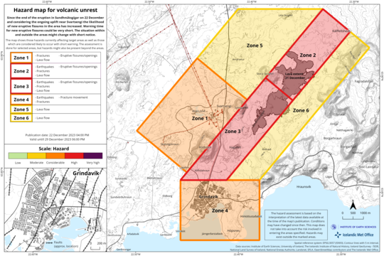
The latest hazard assessment map,
published on 22 December, 16:00 UTC. It is important to note that new
hazards could arise with little warning within the specified areas.
Additionally, the assessment applies only to the specified areas,
whereas hazards could extend or occur beyond the identified zones.
Updated 21 December at 12:55 UTC
Scientists who flew over the eruption site this morning confirm that no eruptive activity is visible and that lava flow from the craters seems to have ceased. Glowing is still visible in the lava field, possibly within closed channels. This was also confirmed by an Elfu staff member in Sýlingarfell. The activity appears to have diminished late last night or very early this morning. However, it is still possible that lava is flowing in closed channels, so it is premature to declare the eruption over.
Earthquake activity has continued to decrease, and over the last 24 hours, approximately 70 minor earthquakes were measured over the magma conduits. The largest quake yesterday occurred at 14:27 and measured 1.4 in magnitude, while the largest since midnight last night was magnitude 1.9. Deformation measurements at Svartsengi show little movement, but measurements over the next few days will further clarify the situation there.
Gas dispersion, mainly due to the degassing of the lava field, will be southeastward and out to sea today. Tomorrow, with a slower northeast wind, the gas will travel southwest.
At this point, it is difficult to predict the continuation of the eruption, but scientists at the Meteorological Office are constantly assessing the latest data and continue to closely monitor the area.
Updated 20 December at 18:50 UTC
The eruption that began in the Sundhnúksgígar crater row on 18 December started with considerable force, and the warning period was short. About 90 minutes passed from the first signs of seismicity until the eruption began. The eruption occurred on the magma intrusion that formed on 10 November. The magma is sourced most likely from beneath Svartsengi, where the land has risen repeatedly since 2020.
In the last 24 hours, the highest activity in the eruption has remained around the middle of the fissure that opened on 18 December. Seismic activity has been relatively steady, and there have been little changes in deformation since the eruption began. Considering this, the Icelandic Meteorological Office (IMO) assesses that the likelihood of a new eruption forming without warning nearby Grindavík has decreased. Therefore, IMO has issued a new hazard assessment map that will take effect tomorrow, Thursday, 21 December at 7:00 UTC. The hazard assessment map is valid until 28 December. It should be noted that although the likelihood of vent formation within area 4 has decreased, the hazard level in that area is nevertheless considered substantial. Even though the activity has decreased since the eruption began, the intensity of the eruption is still significant and comparable to eruptions at Fagradalsfjall. It has also been shown that the magma can reach the surface quickly, leaving little time to issue warnings.

Because of the volcanic eruption that began at Sundhnúksgígar crater row on 18 December, there is an increased likelihood of further vent openings on the original fissure. Based on the sudden onset of the eruption at Sundhnúksgígar, the warning time for new fissure openings could be very short.
Updated 20 December at 17:00 UTC
The vigor of the eruption continues to diminish. New images of the area show that currently two craters are erupting. The most active today is the crater directly east of Sýlingarfell which is the southernmost of the craters that were active yesterday.
Lava continues to mostly flow east from the volcanic vents, but a lava tongue has also run west, north of Stóra-Skógfell. The southernmost edge of the lava does not appear to be advancing. Satellite images taken last night show that the lava field is about 3.7 square kilometers in size.
Wind will turn northwesterly tonight and tomorrow, and pollution will be transported southeastward and out to sea. The Icelandic Meteorological Office regularly issues gas pollution forecasts.
There has been a significant decrease in earthquake activity, and over the last 24 hours, about 80 small tremors have been measured over the magma conduits. The largest quake was 2.2 in magnitude at 10:55 am yesterday morning, and the largest since midnight is 1.2 in magnitude.
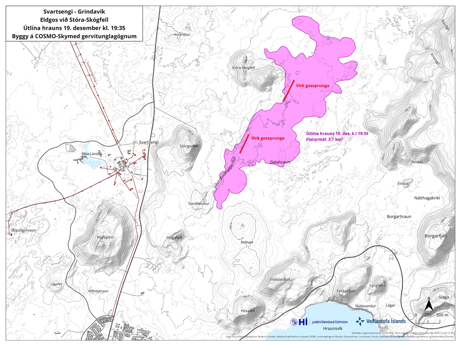
Updated 19 December at 18:30 UTC
The eruption continues to weaken. New aerial images of the area show that there are now three vents erupting southeast of Stóra-Skógfell, down from the previous five. The lava has mostly flowed east from the eruption site, but there is also a lava tongue flowing west from the region north of Stóra-Skógfell.
Since the eruption began, about 320 earthquakes have been measured over the magma channels. The largest earthquake, with a magnitude of 4.1, occurred at 23:25 on Monday. After midnight, seismic activity significantly decreased, and since 12:00 today, only 10 earthquakes have been recorded in the region. Following the eruption at Sundhnúksgíga, the land in Svartsengi subsided more than 5 cm. Previously, the land had risen there by about 35 cm since the formation of the magma channel on November 10. It is too early to determine if magma will continue to accumulate under Svartsengi and whether the land will start to rise again.
While the eruption continues at Sundhnúksgíga, there is an increased likelihood that more vents may open along the original fissure as well as further north or south. Looking back at the lead-up to the eruption reveals that there were approximately 90 minutes between the first indicators and the start of the eruption. Therefore, the warning time for new vent openings at Sundhnúk could be very short.
Updated 19 December at 14:30 UTC
The size of the volcanic eruption at Sundhnúksgígar continues to diminish. The lava flow is estimated to be about one-quarter of what it was at the beginning of the eruption on 18 December, and a third of the original fissure is active. The lava fountains are also lower than at the start of the eruption, reaching about 30 meters at their highest. These figures are based on visual estimates from a reconnaissance flight early on 19 December.
The development of the eruption is similar to recent eruptions at Fagradalsfjall, where the fissures are starting to contract and form individual eruption vents. Presently, there are about five eruption vents spread along the original fissure.
According to information from scientists who went on a second helicopter flight with the Icelandic Coast Guard at around 04:00 UTC today, the total length of the fissure eruption has not changed much from the beginning. There was little activity at the southern end of the fissure near Hagafell, and the majority of the lava flow is heading east towards Fagradalsfjall. Two streams reach west, both north of Stóra-Skógfell.
At the time of publication, the volcanic plume is drifting from the west and northwest. Gas pollution might be noticeable in Vestmannaeyjar today, but not elsewhere in populated areas. According to the weather forecast, gas pollution might be detected in the capital area late tonight or tomorrow morning.
A new hazard assessment map is being prepared, and it will be published later today.
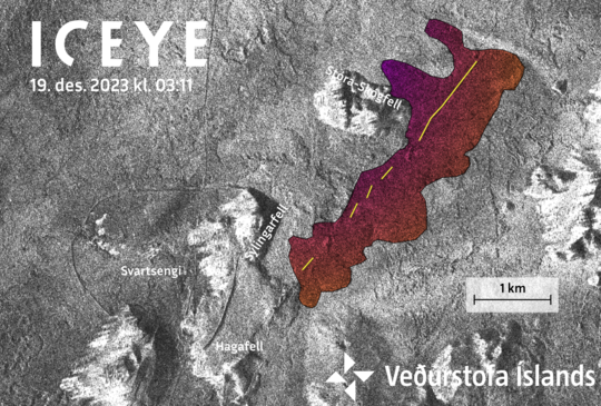
Amplitude image from an ICEYE satellite acquired at 03:11 this morning (19 Dec. 2023). Preliminary analysis of this image show the new eruptive fissure (yellow line) and lava flow (colored area). Notice that he dams built around Svartsengi are clearly visible.
Updated 19 December at 3:00
The intensity of the volcanic eruption, which started about four hours ago, is decreasing. This is evident from seismic and GPS measurements. The fact that the activity is decreasing already is not an indication of how long the eruption will last, but rather that the eruption is reaching a state of equilibrium. This development has been observed at the beginning of all eruptions on the Reykjanes Peninsula in recent years.
The eruptive fissure is about 4 km long, with the northern end just east of Stóra-Skógfell and the southern end just east of Sundhnúk. The distance from the southern end to the edge of Grindavík is almost 3 km.
The Icelandic Meteorological Office continues to monitor the activity and is in direct contact with civil protection and response units in the area. A meeting of scientists will be held tomorrow morning to evaluate the overnight development of the eruption.
This news will be updated at 09:00 on 19 December.
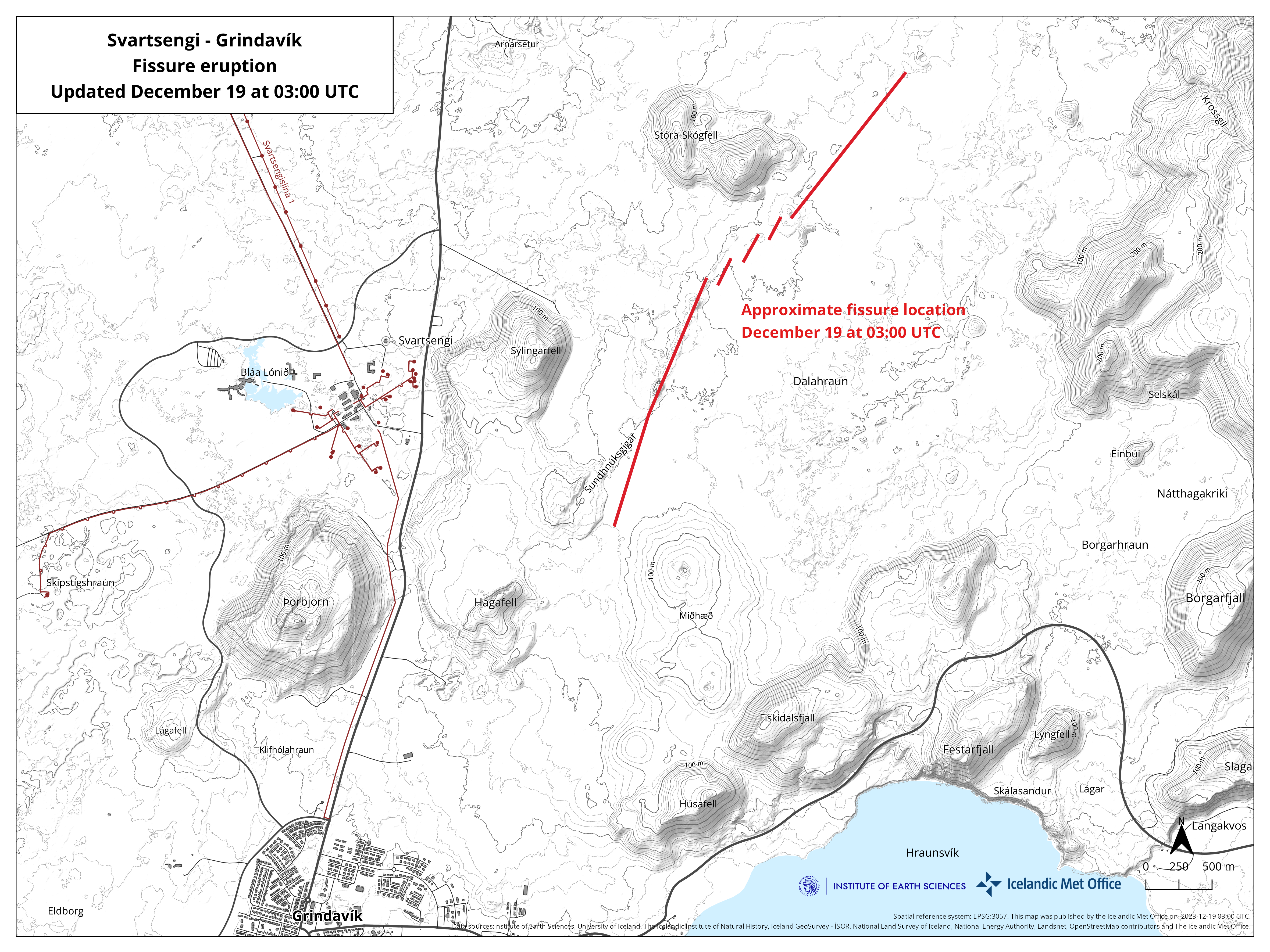
Updated 19 December at 02:10
According to the latest aerial observations and seismicity, the eruption fissure is expanding to the south. At the time of publication, the southern end of the fissure was close to Sundhnúkur.
The eruption is located on the dyke intrusion that formed in November. The rate of lava discharge during the first two hours of the eruption was thought to be on a scale of hundreds of cubic metres per second, with the largest lava fountains on the northern end of the fissures.
Lava is spreading laterally from either side of the newly opened fissures. From real-time GPS measurements, significant ground deformation has accompanied the opening of the eruption fissures.
Since midnight on 19 December, the level of seismicity at the eruption site has decreased. Additionally, estimates of fissure lengthening suggest that the eruption has decreased in intensity since its onset at 22:17 on 18 December.
Updated 18 December at 23:00
At 22:17 this evening, a volcanic eruption began north of Grindavík on the Reykjanes peninsula. The eruption is located close to Sundhnúkagígar, about four kilometres northeast of Grindavík, and it can be seen on nearby web cameras. The eruption was preceded by an earthquake swarm that started at 21:00.
A Coast Guard helicopter will take off shortly to confirm the exact location and size of the eruption.
More information will be available soon.
Updated 16 December at 14:00 UTC
At this stage it is too early to say if magma accumulation at Svartsengi has stopped and the inflation is over. The rate of deformation has decreased somewhat in recent days, but more data is needed to interpret the possible development of the activity in Svartsengi.
Scientists will continue to analyze the data in the coming days.
A new hazard map will be released on Wednesday December 20th, which will reflect the interpretation of the latest data.
Updated 15. December at 13:00 UTC
Generally weak seismicity continues in the area affected by the dike and is mostly concentrated near Hagafell. Since Tuesday December 12, 460 earthquakes, 30 of which were greater than M1.0, have been measured. The largest earthquake in this time was M2.8 near Hagafell on Tuesday morning. Data from GPS stations and satellite images show that uplift due to the accumulation of magma continues around Svartsengi. While magma continues to accumulate in this area, further dikes or an eruption remain possible.
The hazard map published on December 6 Icelandic map here below continues to be valid until December 20. Conditions inside and outside the demarcated hazard zones can change with little warning.

Updated 13. December at 11:15 UTC
The area around Svartsengi continues to inflate. The rate of inflation has decreased somewhat since Friday, but it is still greater than it was prior to the formation of the dike that traveled under Grindavík November 10 .
While magma continues to accumulate around Svartsengi, further dikes or an eruption remain possible.
If another dike forms it is considered to be likeliest that it would follow the same path as the November 10 dike. The most likely location for a potential eruption under these conditions is assessed to be north of Grindavík in the direction of Hagafell and the area around Sundhnúkagígar.
Seismic activity continues at a similar level to the previous days. It is generally weak and mostly in the area around Hagafell.
Updated 6. December at 18:00 UTC
Latest geodetic modelling results suggests that the magma inflow to the dike that formed on November 10 has likely ceased. The chances of an eruption happening along the dike at this time have therefore significantly decreased. However, magma accumulation continues beneath Svartsengi.
The ongoing activity at Svartsengi, which began in October, is not yet over and a new chapter may have begun with an increased chance of a new magma propagation and, subsequently, increased likelihood of an eruption.
As previously mentioned, the dike beneath Grindavík was fed by magma accumulating beneath Svartsengi. It is likely that this sequence of events will repeat. When looking at the overall pattern with repeated magma accumulation, it can be estimated that the next magma propagation from Svartsengi might be on a smaller scale than the one previously formed on November 10. A magma propagation could persist for several hours or days with an increased risk due to seismic activity and deformation during that period.
Signs of a magma propagation include a sudden increase in seismic activity and rapid changes in ground deformation. These signs can be observed on instruments several hours before the magma propagation is likely to pose a threat to Svartsengi or Grindavík. If a magma propagation occurs, the Icelandic Meteorological Office will immediately activate response plans for public safety.
Following a magma propagation, the likelihood of an eruption increases. As mentioned above, it is most likely that magma will propagate from Svartsengi into the previously formed dike on November 10. Making it the most likely area for an eruption.
It is not possible to estimate when the next magma propagation will occur. The uncertainty is considerable, and a magma propagation could happen in the next few days or possibly after several months.
The Icelandic Meteorological Office continues to monitor the area closely and continues to monitor any signs of magma propagation and other changes that could pose further danger in the area near Svartsengi and Grindavík.
Comparison of Svartsengi and Krafla Fires
In the last week, approximately 300-500 earthquakes were detected in a 24-hour period around the dike intrusion. The largest earthquake was a M2.7 near Hagafell on Friday evening. Since midnight today, about 90 earthquakes have been detected along the dike, all measuring below a M2.0. The majority of seismic activity continues to be concentrated along the middle of the dike at about 3-4 km depth. Due to subsidence in Svartsengi the stress in the Earth's crust has changed. Until the previous stress level is reached, it can be expected that minor seismicity continuous in the region.
Despite the recent decrease in seismic activity in the last weeks, further unrest can be expected on the Reykjanes Peninsula. Examples of similar unrest can be seen in the Krafla Fires that began in 1975. Over a 10-year period, there were 20 magma propagations, with 9 of them resulting in an eruption (see explanatory image below). In the Krafla Fires, all of the magma propagations fed the same dike but they varied in size. A similar recurrence can also be observed in the activity around Fagradalsfjall.
The latest geodetic modeling results indicate that the volume of magma currently accumulated under Svartsengi is considerably less than the volume accumulated before the dike intrusion on November 10. When looking at the magma accumulation and magma propagation in the Krafla Fires, it is evident that the largest amount of magma had accumulated in the Krafla caldera before the first volcanic eruption. A smaller amount of magma accumulated in the caldera before the next magma propagation occurred. It can be estimated that a similar development will occur in relation to magma accumulation under Svartsengi, and a smaller amount of magma needs to accumulate before triggering the next magma propagation into the dike. It is likely that slowly increasing seismicity will be detected before a new magma propagation takes place, indicating increased pressure under Svartsengi.
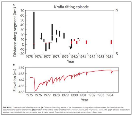
Updated 1. December at 16:50 UTC
The seismicity on the peninsula continues to decrease. For the past few days, the automatic earthquake location system has been detecting relatively few earthquakes, mostly micro-earthquakes below magnitude one. The most recent seismicity is concentrated in the area between Sýlingarfell and Hagafell, where most likely the dike is fed by magma accumulating beneath Svartsengi. Some deformation is still detected at the cGPS stations located close to the dike, but the signal is now mainly interpreted as the response of the crust to the inflation ongoing in the Svartsengi area.
Even though the activity along the dike and its vicinity is now occurring at very low intensity, the inflation which started in Svartsengi few days after the dike formed, continues at a fairly stable rate. Some cGPS stations around Svartsengi and Mt. Þorbjörn shows a slow declining trend, but other stations still show a constant trend suggesting that the inflow rate of magma at depth has not reduced significantly.
The process which began on 25 October with a significant seismic swarm and peaked on 10 November with the formation of a 15 km long magmatic dike is not over. With certainty it can be stated that a phase has started where a similar sequence of events might repeat in time.
At this stage, though, is difficult to say when the next energetic intrusion of magma at shallower depth might occur and if it will occur in a similar area or not. The IMO continues to maintain the surveillance of the area at high level.
Updated 29. November at 17:00 UTC
The seismic activity has continued to slowly decrease over the last two days. Yesterday, about 340 earthquakes were measured near the magma intrusion in the area east of Sýlingarfell, and since midnight today, around 150 earthquakes have been recorded. Most of the earthquakes have been smaller than magnitude 1.0.
The rate of uplift near Svartsengi has been decreasing, but it is still ongoing at a rate of about 1 cm per day. The majority of the displacement in the region is currently attributed to inflow under Svartsengi with a smaller portion flowing into the magmatic intrusion. In other words, the deformation measured and modeled at Svartsengi is now much greater than that seen near the magma intrusion, but all deformation signals are slowly diminishing. Observed signs of inflow into the magmatic intrusion is now limited to the area east of Sýlingarfell. Despite the slowing down of seismic activity and deformation, an eruption is still considered to be possible. If an eruption does occur, the location thought to be most likely is east of Sýlingarfell.
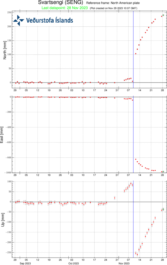
Here is a timeline for the GPS station Svartsengi (SENG). It shows movements over the last 90 days in the north, east, and vertical directions. The blue line marks the magma intrusion from November 10th until today.
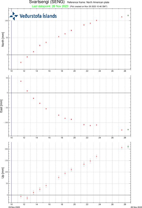
This image depicts the movements from the station since November 10th until today.
Updated 27. November at 16:30 UTC
Seismic activity has been relatively stable for the past few days with a daily rate of about 500 earthquakes in the area of the magmatic dike. Most of the seismicity continues to be nearby Sýlingarfell and Hagafell. Around midnight a short-lived seismic swarm commenced in the vicinity of Sýlingarfell and lasted for roughly one hour. A total of 170 earthquakes were detected in the area at a depth of 3-5 km. The earthquakes were almost all very small with one M3.0.
Data from GPS stations and satellite images show that uplift continues in the area of Svartsengi and deformation is still ongoing along and around the dike. The elevated seismic activity which occurred around midnight isn´t associated with any changes to the ongoing deformation. Both seismic and deformation data suggest that magma continues to accumulate beneath Svartsengi and to flow into the middle portion of the dike which formed on 10 November. The seismic swarm that occurred this night might indicate increasing pressure within the dike.
In light of the available data and the newest analysis, an eruption along the dike is still considered likely as long as the magma inflow continues. It is assessed that the area with the highest likelihood for an eruption is in the middle part of the dike between Hagafell and Sýlingarfell. The hazard map published by the IMO on 22 November remains valid.
Additional geodetical modelling has been performed to reconstruct the evolution of the dike which formed on 10 November. These newest results suggest that the dike at depth could be wider than initially assessed. The time needed to solidify the magma that intruded into the dike would be therefore estimated to be on the order of a few months.
This picture shows reviewed earthquakes since 24. November.
Updated 24. November at 13:30 UTC
Yesterday, around 650 earthquakes were measured near the dike intrusion north of Grindavík, and since midnight today, nearly 300 earthquakes have been detected. Most of the earthquakes are below M1.0, but the largest earthquake in the last two days was M2.7 near Hagafell. The seismic activity continues to decrease.
Data from GPS measurements show that deformation continues near Svartsengi, and deformation is still measured around the dike intrusion. However, there are indications that the rate of deformation has decreased based on data from the past week. Though, the interpretation of deformation data is complex at this stage. This is because other processes, such as fault movements related to earthquakes and the viscoelastic response of the Earth's crust to unrest in the area, have an impact on the deformation signals.
Considering the latest interpretation of all data, the likelihood of a volcanic eruption at some location along the length of the magma intrusion persists. It is possible that magma could emerge in the area between Hagafell and Sýlingarfell. However, as crustal relaxation continues to occur and seismicity decreases, along with a decrease in magma inflow to the intrusion, the likelihood of an imminent volcanic eruption diminishes with time.
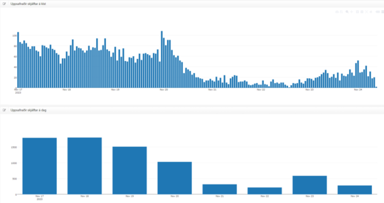
Overview of seismic activity from Friday, November 17th. The upper graph shows the number of earthquakes per hour, and the lower graph shows the number of earthquakes per day. The effects of strong wind and heavy sea swell on the Reykjanes Peninsula on November 21st and 22nd are evident in fewer recorded earthquakes due to reduced sensitivity of the seismic network during that time.
Updated 23. November at 12:30 UTC
On 21 November, approximately 300 earthquakes were detected in the region of the magma intrusion. From midnight on 22 November to 18:00 UTC on the same day, around 100 earthquakes had been recorded in the same region, which is considerably less than in recent days. Additionally, the intensity of earthquakes above magnitude 2.0 has decreased. During the period of severe weather on 21 and 22 November, efforts were made to assess how weather conditions and ocean swell influences IMO's monitoring systems.
Magma inflow rates and crustal adjustments related to the formation of the intrusion continue to diminish. Additionally, crustal uplift near to Svartsengi continues at a similar pace. Geodetical models based on data from 21 November suggest that the influx into the intrusion is greatest near to the Sundhnúkur crater row, about 4 km northeast of Grindavík. Minor surface displacements have been detected within the graben region in and around Grindavík.
The likelihood of a volcanic eruption at some location along the length of the magma intrusion persists. It is possible that magma could emerge in the area between Hagafell and Sýlingarfell. However, as crustal relaxation continues to occur and seismicity decreases, along with a decrease in magma inflow to the intrusion, the likelihood of an imminent volcanic eruption diminishes with time.
Based on the latest data, and considering the evolution of activity since 10 November, the likelihood of a sudden eruption within the Grindavík urban area is decreasing daily, and it is presently assessed as low. It can be assumed that newly emplaced magma beneath Grindavík has solidified partially, thereby reducing the likelihood that the magma will reach the surface within the city limits. However, we emphasise that the possibility of a volcanic eruption at some point along the length of the intrusion, particularly between Hagafell and Sýlingarfell, remains plausible.
It is apparent that there is a strong connection between crustal uplift in the Svartsengi region and the sudden, initial propagation of the magma intrusion on 10 November. Models indicate that the magma in the reservoir beneath Svartsengi may have flowed eastward towards the Sundhnúkur craters, subsequently forming the 15-km-long volcanic intrusion. While crustal uplift in Svartsengi continues, it is expected that the accumulating magma may flow again eastwards, potentially reactivating the intrusion. It is also feasible that a magma intrusion could form to the west of the magma body accumulating beneath Svartsengi. Precursors to such an event would include pronounced seismicity and rapid ground displacements, both of which are monitored closely by IMO continuously.
Updated 21. November at 15:30 UTC
Since midnight today, 165 earthquakes have been recorded due to the ongoing volcanic unrest, all below magnitude 2.0 in size. The level of seismicity today is considerably lower than in the recent days, when 1,500-1,800 earthquakes were recorded each day. It can be expected that the intense weather affecting the country has an impact on the sensitivity of the seismic monitoring system to detect the smallest earthquakes, making it difficult to assess whether the seismic activity is decreasing overall.
The deformation associated with the magma intrusion that formed on November 10 continues. Likewise, crustal uplift continues near Svartsengi. The speed of the uplift at Svartsengi has remained almost the same during the past 24 hours.
In collaboration with specialists from the University of Iceland, IMO continues to monitor the area as effectively as possible, constantly re-evaluating and interpreting the data received.
As mentioned before, IMO has increased surveillance in and around Grindavík and the area around Hagafell. The effectiveness of this surveillance depends on the high sensitivity of earthquake and real-time GPS measurements, which are highly dependent on weather conditions. Given the weather forecast for the next two days, which indicates precipitation and significant wind, it can be expected that both seismic monitoring and real-time GPS observations will be affected. Ocean waves also create microseisms that overwhelm the low-frequency detection capabilities of seismometers on the Reykjanes Peninsula. Fog and hail showers could also affect the visual confirmation of an eruption, adding to the monitoring and assessment uncertainty.
Updated 20. November at 13:20 UTC
Since midnight today, over 700 earthquakes have been detected in the region of the magma intrusion, the largest of which was magnitude 2.7 near to Hagafell.
In recent days, between 1,500 and 1,800 daily earthquakes have been measured in the region, with the largest event registering magnitude 3.0 last Friday (17 November). Based on radar imagery from 18 and 19 November 2023, the latest interferogram of the magma intrusion and the surrounding area shows significant crustal uplift in the vicinity of Svartsengi. The newly processed interferogram was reviewed by experts during the weekend (18 – 19 November) from the Icelandic Meteorological Office, the University of Iceland, and the Department of Civil Protection and Emergency Management. The results were also discussed in today's status meeting, held at IMO. The rapid, ongoing uplift close to Svartsengi is occurring in the same area where uplift was measured before the magma intrusion formed on November 10. Geodetic models derived from satellite images show that the uplift in Svartsengi area is considerably faster than before. Generally, when a magma intrusion forms, subsidence occurs above the centreline of the intrusion, as seen in Grindavík, with signs of land uplift discernible adjacent to the intrusion. Crustal uplift in the Svartsengi region due to magma accumulating at depth has been measurable since the intrusion began to form on 10 November. Initially, the uplift sign was influenced by the formation of the intrusion, but now the dominance of deep magma recharge is apparent.
The clear sign of crustal uplift in Svartsengi region does not change the likelihood of an eruption from the magma intrusion. This is assessed, amongst other things, on the fact that the Earth's crust over the magma intrusion is much weaker than the crust over the uplift region close to Svartsengi. As long as there is not significant seismicity in the Svartsengi region, there is not a high likelihood of an eruption at that location. Moreover, an eruption is still deemed more likely from the intrusion, particularly if there is a sudden, large inflow of magma into the intrusion.
Our monitoring and hazard assessment preparations are still based on the assumption that the situation could change suddenly with little warning. The Icelandic Meteorological Office, in close cooperation with experts from the University of Iceland, will continue to monitor the area closely, with the goal of continually interpreting and evaluating all available monitoring observations.
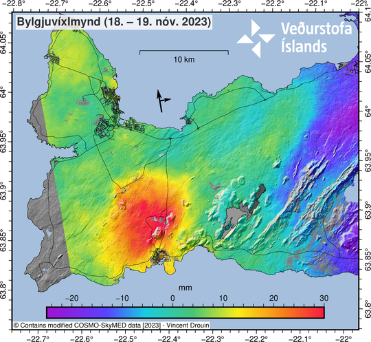
COSMO-Skymed interferogram spanning 24-hours between 18−19 November at 06:41. The broad uplift signal visible in orange/red around Svartsengi is indicative of a deep inflation (>5 km) taking place.
Updated 18 November at 15:00 UTC
Seismicity related to the magma intrusion that formed suddenly a week ago remains high and constant. Approximately 1,700 earthquakes have been recorded in the last 24 hours, 1.000 of those recorded since midnight. The largest earthquake during the last 24 hours had a magnitude of 2.8 and occurred near Hagafell, 3.5 km NNE of Grindavík.
Updated 17 November at 12:00 UTC
Seismicity related to the magma intrusion that formed suddenly a week ago remains high and constant, although the level of activity is substantially lower than 10 – 12 November 2023. Approximately 2,000 earthquakes have been recorded in the last 24 hours, with most activity in an area north of Hagafell, towards the Sundhnúkar craters. Most of the seismicity is micro-earthquake activity comprising earthquakes under M 1. The largest earthquake during the last 24 hours occurred at 06:35 near Hagefell; it had a magnitude of 3.0.
According to GPS measurements, ground deformation continues but at a decreasing rate. The latest geophysical models based on GPS data and satellite imagery indicate that the largest movements in the magma intrusion are occurring north of Grindavík, near Hagafell. If magma manages to reach the surface, Hagafell is thought to be a prime location for an eruption.
Subsidence over the magma intrusion remains active, although measurements show a slight slowdown from day to day. Presently, GPS stations located in and around Grindavík, near the center of the subsidence zone, show about 3–4 cm of subsidence per day.
Based on the interpretation of the latest data and model results, a volcanic eruption remains likely, with the highest likelihood of it starting north of Grindavík near Hagafell.

A map showing the extent of the subsidence over the magma instrusion in and around Grindavík. A GPS station (GRIC) located near the center of the subsidence has recorded a total subsidence of 25 cm since the beginning of the event.
Updated 16 November at 17:50 UTC
Over the past few days, seismicity near the magma intrusion has remained relatively stable. As of 17:00 today, about 1,400 earthquakes have been recorded since midnight, the largest being 2.9 in magnitude, sourced near Hagafell just after 13:00. Most of the earthquakes were under magnitude 2, with the highest concentration of activity near Hagafell.
Deformation related to the magma intrusion continues to be measured, although it has slowed slightly since yesterday. The latest models, derived from GPS measurements and satellite data, still suggest that the largest movements of the magma intrusion are north of Grindavík near Hagafell. If magma manages to break through to the surface, it is most likely to happen in the region of Hagafell.
Eartly today, sulphur dioxide (SO2), a type of volcanic gas, was measured from a borehole at Svartsengi, located just north of Þorbjörn. The borehole extends eastward to considerable depth towards the Sundhnúkur crater row. The base of the borehole therefore reaches close to the location in the crust was the magma intrusion is located. Further gas measurements will be conducted tomorrow, 17 November. The detection of volcanic gas from such a borehole is another independent confirmation of the presence of magma north of Hagafell, as indicated by seismic activity and geophysical modelling results.
The likelihood of an eruption remains high. Monitoring continues for signs of shallowing seismicity and sudden crustal movements, which could be precursors to magma breaking its way to the surface. At the time of writing, no such signs had been observed.
Updated 15. November at 11:30 UTC
Since
midnight, about 800 earthquakes have been measured, most of them in the middle
of the magma dyke at Sundhnúk at a depth of about 3-5 km. Seismic activity has
remained constant since 11th of November. The main monitoring focus
on seismic activity remains in the area of the dike and Grindavík.
Deformation measurements show
continued deformation in the area. They are consistent with magma still flowing
into the dyke. Part of the magma dyke seems to be solidifying, especially at
the edges, but not at the magma inflow area, which is believed to be near
Sundhnúk.
Measurements of sulfur
dioxide (SO2) seem to show fluctuating degassing due to the magma dyke, but
further measurements are needed for confirmation. Analysis of this data is
currently underway in collaboration with the Chalmers University in Sweden.
The fiber optic cable of HS Orka, that runs from Svartsengi west of Þorbjörn to Arfadalsvík is beeing used as a continuous seismic measuring line with high sensitivity. This is a new technology that has developed in recent years and is now used as additional measurements in collaboration with HS Orku and ETH in Switzerland.
Overall, the situation seems to be unchanged since yesterday. The probability of an eruption is still considered high. In the event of an eruption, the most likely location is at the magma dyke.
Updated 14. November at 19:20 UTC
Earlier this week, IMO specialists installed two DOAS remote sensing instruments on Húsafell. These instruments can measure the presence and the amount of SO2 in the atmosphere. One of the DOAS instruments detected SO2 yesterday and today at the newly formed graben, located between Sundhnúkagígar and Grindavík. Because of the low amount of daylight, the measurements can be imprecise, and it took time to review the data and interpret it. In the last two days, eastern winds have been prevalent in the area, so it cannot be ruled out that recent strong seismicity has caused the release of SO2 from beneath Fagardalsfjall, as magma at that location has not solidified yet since the eruption in July 2023.
It is hard to estimate the depth from which the SO2 is being released as the process is influenced by magma pressure. However, it is thought that the magma needs to be in the upper hundred meters of the crust in order for SO2 to be released. This is one of the reasons why the DOAS instruments have been sited close to Grindavík.
DOAS (Differential Optical Absorption Spectrometer) is a tool that can detect sulfur dioxide in the atmosphere. The method relies on visible light, which travels through the atmosphere, hits a sensor in the measuring device, which is then analyzed for certain colors (wavelengths) that are missing from the spectrum. Sulfur dioxide absorbs certain wavelengths of light, which means that light hits the measuring instrument in a different way if SO2 is detected. The probe scans certain sectors of the sky, and it provides information on the concentration of sulfur dioxide within the area scanned. DOAS measurements need daylight to work, so operating such instruments in the wintertime in Iceland can be challenging.
Updated 14. November at 12:40 UTC
Since midnight, 14 November, over 700 earthquakes have been located along the orientation of the magma intrusion, the largest of which was M 3.1 near to Hagafell. Last night, 13 November, stress-triggered seismicity occurred close to Kleifarvatn, with the largest earthquake registering M 3.8 at 21:09 UTC. Today, most earthquakes are occurring along the magma intrusion, with the majority being micro-earthquakes, commonly at focal depths of 3 to 5 km.
Deformation measurements, including high-resolution aerial observations, satellite radar imagery, and ground-based GPS observations reveal continued, ongoing ground movements due to the ongoing formation of the magma intrusion. These results are consistent with continued, albeit much lower magma inflow to the region of the intrusion.
Between 12 and 13 November, the inflow is estimated at 75 m3 / s, and the average depth to the top of the magma intrusion is thought to be around 800 m. The inflow and depth estimates are derived from model-based calculations, and they are subject to uncertainty.
Throughout this period of volcanic unrest, the focus has been continuous monitoring of seismicity and ground deformation in the Grindavík – Svartsengi region. To further our monitoring capabilities, we have installed additional GPS stations in and around Grindavík. The latest measurements from these stations show that the graben-like formation is still forming and mechanically active. Furthermore, to increase our ability to warn of an eruption, we have installed ground-based SO2 detectors that overlook Grindavík and south of Sundhnúkur.
In summary, the
likelihood of an eruption remains high. If an eruption occurs, the most likely location with be along the orientation of the magma intrusion, beginning as a fissure eruption.
Updated 13. November at 16:20 UTC
Seismicity along the magma intrusion continues, although the size and intensity of the activity is decreasing. Since midnight today, 13 November, around 900 earthquakes have been detected. The seismic activity is concentrated on the region of the intrusion, between Sundhnúkur and Grindavík at a depth of about 2–5 km.
Decreasing rates of ground deformation are seen
in GPS data from Grindavík. Satellite radar results show a graben-like
formation that cuts through part of Grindavík. This feature was first
identified by IMO in satellite radar imagery early on 11 November.
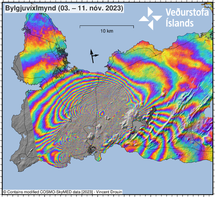
This ascending COSMO-SkyMed (CSK) interferogram covers the time period 3-11 November and shows an extensive deformation field related to the dike intrusion that began on the afternoon of the 10 November within the Reykjanes-Svartsengi volcanic system. This CSK interferogram and the previous (spanning 2-10 November) supported the difficult decision made by Civil Protection to evacuate the town of Grindavík late Friday evening. It also enabled modelling of the dimensions of the dike intrusion (on the 11 November), which provided a median dike length of 15 km and top depth of less than 1 km below the surface. The imagery shows over 1-m of ground displacement in the western part of Grindavík, caused by the propagation of the magma intrusion. From geodetical modelling results, we infer that (as of 12 November) the greatest area of magma upwelling is sourced close to Sundhnúkur, 3.5 km north-northeast of Grindavík.
New geodetic
modelling is currently being undertaken, using an ICEYE interferogram and GNSS
observations spanning the last 24-hours, to better assess the ongoing activity
and provide an estimate of the current magma inflow rates.
According to our latest estimates, the volcanic hazard assessment in and around
Grindavík is unchanged from 12 November. All monitoring systems are being
monitored closely in real-time, especially near Grindavík, for any indications
of sudden change. The natural hazards monitoring team at IMO is operating at maximum
surveillance while the Department of Civil Protection and Emergency Management coordinates
short-term, temporary access to Grindavík today, 13 November.
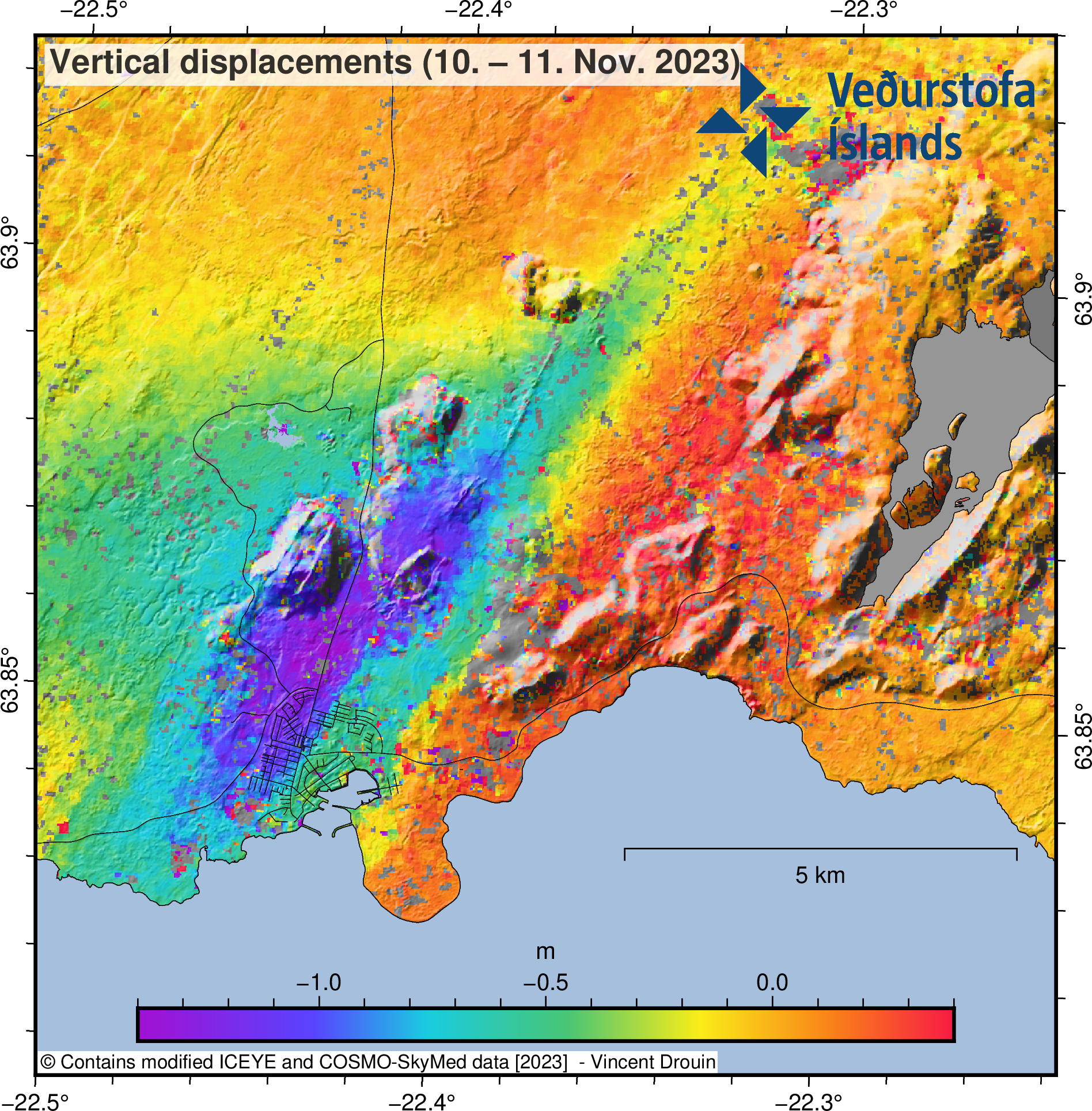
Estimate of the vertical displacements caused by the dike during its initial propagation from Friday afternoon to Saturday morning. The displacements were estimated by combining ICEYE and COSMO-SkyMed pixel offset tracking results.
Updated 12. November at 12:30 UTC
Since the morning of November 11th, seismic activity related to the magma intrusion remains fairly constant. Since midnight November 12th, around 1000 earthquakes have been recorded within the dyke, and all of them have been below M3.0 in magnitude. The most seismic activity has been located in the region north of Grindavík. Most of the earthquakes are at a depth of 3-5 km corresponding to the lower part of the dyke intrusion.
GPS measurements covering the past 24 hours show that deformation associated with the dyke intrusion that formed on Friday, November 10th has slowed. This can be an indication that magma is moving closer to the surface, new models will be run as soon as new data comes in to update the model.
It was a joint assessment from the meeting, based on the latest data, that there is scope for temporary measures under the control of the Department of Civil Protection and Emergency Management to collect necessities for the residents and attend to urgent errands in Grindavík and the surrounding area. During such operations, it is necessary to increase the vigilance of the area through additional monitoring with the aim of improving the detection of magma reaching the surface. It was the opinion of the scientists that it would be advisable to start these operations immediately, as uncertainty about the progress of the event grows as the day progresses. The final decision on whether these actions will be taken, and their implementation is in the hands of public safety and the Police Chief in Suðurnes.
In light of this joint assessment has the Police Chief in Suðurnes decided to allow inhabitant to part of restricted area in Þorkötlustaðahverfi and it is only to retrieve vital items, pets and livestock. This will be organised and controlled operation by the Police. This permission only applies to Þorkötlustaðahverfi. Note, special operation is ongoing to pick up all horses in the area north of Austurver.
This news has been updated since the latest information from the Police Chief in Suðurnes.Updated 11. November at 18:30 UTC
At 18:00 today, 11 November, a status meeting concluded between scientists at the Icelandic Meteorological Office, the University of Iceland, and the Department of Civil Protection and Emergency Management. The purpose of the meeting was to discuss the latest measurements of seismicity and ground deformation in the region of Grindavík, in addition to reviewing the latest geophysical models and hazard assessments. From combined assessments of satellite radar imagery, ground-based GPS measurements, and seismicity, it was concluded that the ongoing dike intrusion represents a serious volcanic hazard.
From geophysical models of the dike intrusion, it is estimated that the intrusion is propagating upwards slowly, with magma thought to be 800 m beneath the surface. The exact location of a possible eruption site is unknown, but the 15-km length and orientation of the dike gives a good indication of possible sources. The overall assessment from the status meeting was that the likelihood of a volcanic eruption is high, and that an eruption could be possible on a timescale of just days. Based on the extent of the dike, magma could emerge from its southern, just outside of Grindavik. Therefore, the likelihood of a submarine eruption has also increased, so preparations must be made for the possibility of explosive activity. A hazard area has been defined based on the location of the dike, as shown in the map.
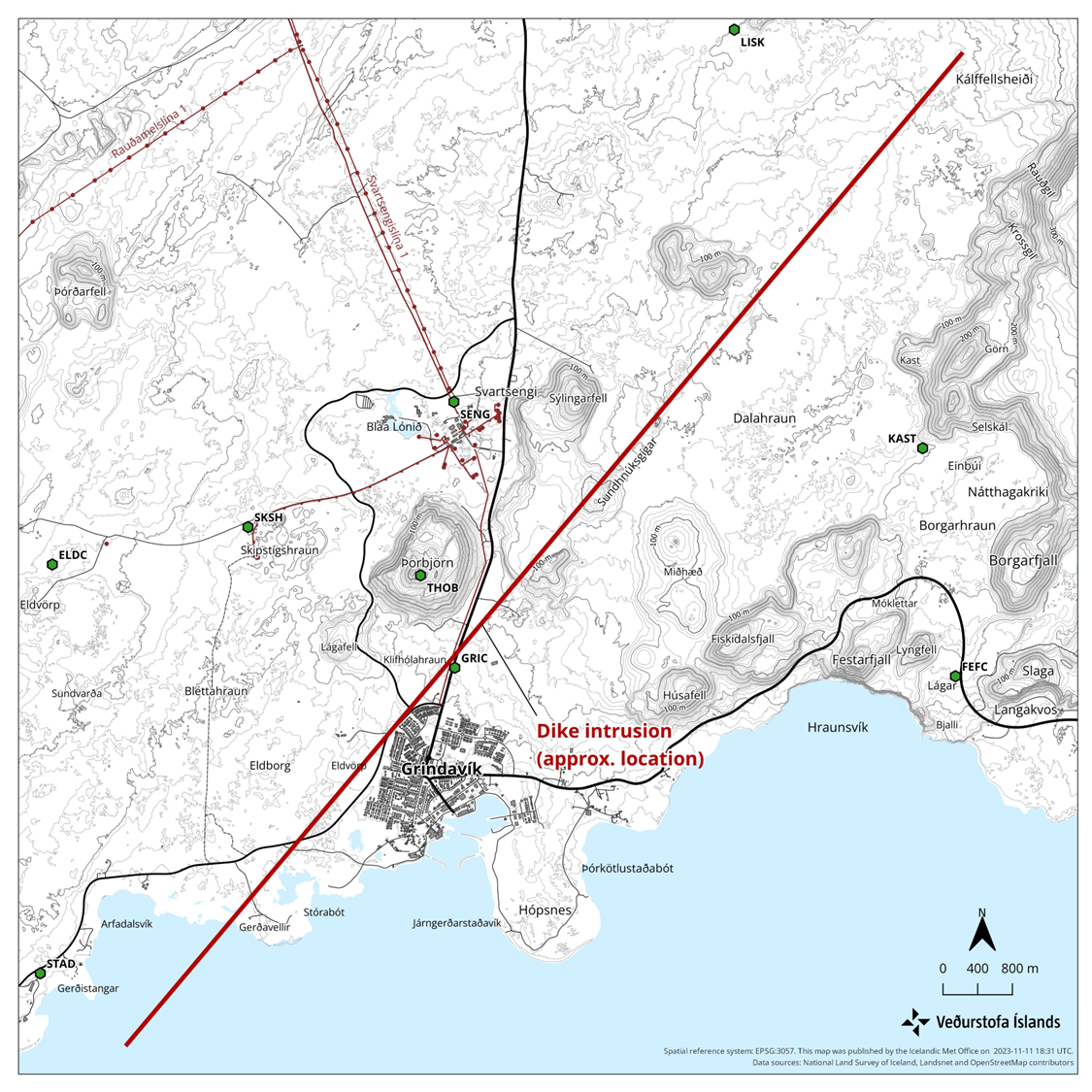
Status map showing the location of the dike intrusion based on combined satellite radar imagery, GPS measurements, and geophysical modelling.
Updated 11. November at 12:00pm
Since midnight, around 800 earthquakes have been measured in the region where the magma intrusion is occurring. The earthquake activity has diminished slightly in the past hours, but it remains high. Most of the recent earthquakes have occurred close to Grindavík, where the southwest end of the magmatic dyke is estimated to be located.
Analysis of the earthquakes from today and yesterday is ongoing. The goal of this work is to better understand the evolution of the magma intrusion. Presently, the data indicates that the magma intrusion extends from Stóra-Skógsfell in the north to Grindavík in the south, where it extends beneath the sea. In accordance with the latest preliminary models, using the most recent satellite data acquired last night, the shallowest depth of the top of the magma intrusion north of Grindavík is 1.5 km. Joint interpretation of the ground and satellite measurements indicate that the size of the magma intrusion and the rate at which it is moving are several times larger than have been measured previously on the Reykjanes Peninsula. Our assessment is that an eruption, if it were to occur, will originate from the northern side of the magma intrusion. This means that there is a greater likelihood of an eruption beginning close to Sundhnjúkagígur.
Scientists are meeting regularly to interpret the data and update the latest models and hazard assessments. A meeting for journalists will be held at 12:00 at the Department of Civil Protection and Emergency Management. The current conditions and future scenarios will be discussed.
The likelihood of a volcanic eruption occurring in the near future is deemed considerable.
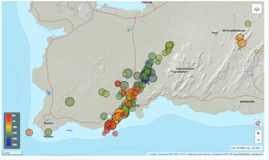
Reviewed earthquakes since 9pm last night.
Updated 10. November at 11:30pm
Significant changes have occurred in the seismic activity measured near Sundhnjúkagígar north of Grindavík and deformation observed in the Reykjanes Peninsula this afternoon. The seismic activity has moved south towards Grindavík. Based on how the seismic activity has evolved since 6 PM today, along with results from GPS measurements, there is a likelihood that a magma intrusion has extended beneath Grindavík. In light of this outcome, the police chief in Suðurnes, in cooperation with the Civil Protection Authorities, has decided to evacuate Grindavík. An emergency level of civil protection is now in effect. This is not an emergency evacuation. Residents of Grindavík are advised to proceed with caution.
At this stage, it is not possible to determine exactly whether and where magma might reach the surface. There are indications that a considerable amount of magma is moving in an area extending from Sundhnjúkagígum in the north towards Grindavík. The amount of magma involved is significantly more than what was observed in the largest magma intrusions associated with the eruptions at Fagradalsfjall. Further data is being collected to calculate models that provide a more accurate picture of the magma intrusion. It is currently not possible to say when this work will be completed.
Updated 10. November at 8pm
The seismic activity currently measured at Sundhnjúkagígar occurs within an area about 3 km northeast of Grindavík. The shallowest earthquakes measured now are at a depth of about 3-3.5 km.
The signs that can be seen now at Sundhnjúkagígar are similar to those seen on the eve of the first eruption at Fagradalsfjall in 2021 and are very similar to the seismic activity that was measured about a month before that eruption. The most likely scenario now, taking into account the activity that culminated in the onset of the March 19th 2021, is that it will take several days (rather than hours) for magma to reach the surface.
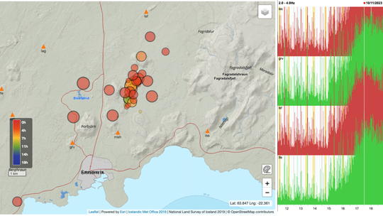
Earthquakes on the 10th of November (until 6:48pm). The Icelandic Meteorological Office's seismic network is shown with triangles. Four seismic stations surrounding the current seismic activity have been showing a large increase in tremor since 3pm.
Updated 10. November at 6:30pm
The National Commissioner of the Icelandic Police, in consultation with the Police Commissioner of Suðurnes, has declared a Civil Protection Alert Phase due to the intense earthquake swarm that commenced 3pm today at Sundhnjúkagígar, north of Grindavík. There is the possibility for larger earthquakes than have been experienced thus far, and this sequence of events could lead to an eruption. The Civil Protection Alert Phase means that the risk is increasing, and measures are being taken to ensure the utmost safety of those who live/stay in the area. This is done by increasing precautions in the relevant area.
The Aviation Color Code has been elevated to orange (heightened unrest with increased likelihood of eruption). IMO is closely monitoring the situation. Residents are encouraged to follow the information provided on Almannavarnir.
Updated 10. November at 2pm
Earlier today, at 12:44, an earthquake of magnitude 4.1 occurred near Sýlingarfell, west of Sundhnjúkagígar. The craters are about 2-3 km northeast of Grindavík. A dense swarm of earthquakes began around 07:00 this morning in the same area, and nearly 800 quakes have been recorded since midnight, including 9 greater than magnitude 3. The depth of the earthquakes is about 5 km. Such earthquake swarms have previously been recorded in this area. It cannot be ruled out that the seismic activity near Sundhnjúkagígar is due to magma movements at depth.
Magma accumulation continues near Þorbjörn at the same depth and at a similar rate as before. It is accompanied by swarm-like seismic activity, as was noticed yesterday and this morning. While magma accumulation continues, ongoing seismic activity can be expected due to stress release in the area. Earthquakes up to magnitude M5.5 can be expected in such swarms, and the seismic activity may shift between areas. At this stage, there are no indications that magma is forcing its way to the surface.
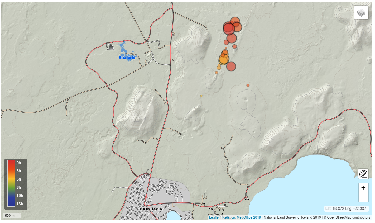
Reviewed earthquakes since midnight
Updated 9. November at 12:20pm
Around 1400 earthquakes have been recorded in the last 24 hours. Seismic activity increased from midnight, and the SIL seismic network has detected seven earthquakes above M4.0 since then. The largest earthquake measured M4.8 at 12:46am. It was located west of Þorbjörn. It is the largest earthquake since the activity began on October 25th. Seven earthquakes M4.0 or larger in size were measured in the area from Eldvörp to the area east of Sýlingarfell. While the accumulation of magma continues, seismic activity can be expected on the Reykjavík Peninsula because the magma intrusion causes increased tension in the area.
According to GPS data at midnight, uplift continues in the area. The GPS data is being reviewed in relation to the seismic activity tonight. Since the beginning of the inflation until today, the uplift has been fairly even, although an acceleration of the process has been observed between days. The seismic activity last night and this morning is an example of this episodic seismic activity that can be expected while magma accumulation is in progress. The fact that there are now larger earthquakes than before in the area does not necessarily mean an increased rate of magma accumulation.
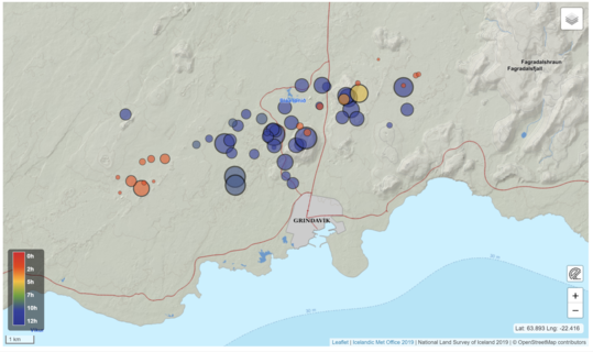
Reviewed earthquakes since midnight last night
Updated 8. November at 2:40pm
Approximately 1200 earthquakes have been measured in the last 24 hours, most of them in the area between Þorbjörn and Sýlingafell, similar to the day before. The largest earthquake was M3.4 at 12:31am last night, just south of Þorbjörn. The seismic activity continues at the same depth as before. It is likely that seismic activity will continue, and be episodic in intensity, while magma accumulation is ongoing.
Uplift continues at a similar rate as before according to Satellite and GNSS data. Interferogram (InSAR) for the period 28th of October – 6th of November showing near-vertical motion confirms this, but it also shows offsets due to fault movements associated with the seismic activity. Updated models based on the same data estimate that magma continues to accumulate in a horizontal sill at a depth of about 5 km and since the beginning of the inflation event (October 27th) the average inflow is estimated about 5 m3/s (uncertainty is ±2 m3/s)
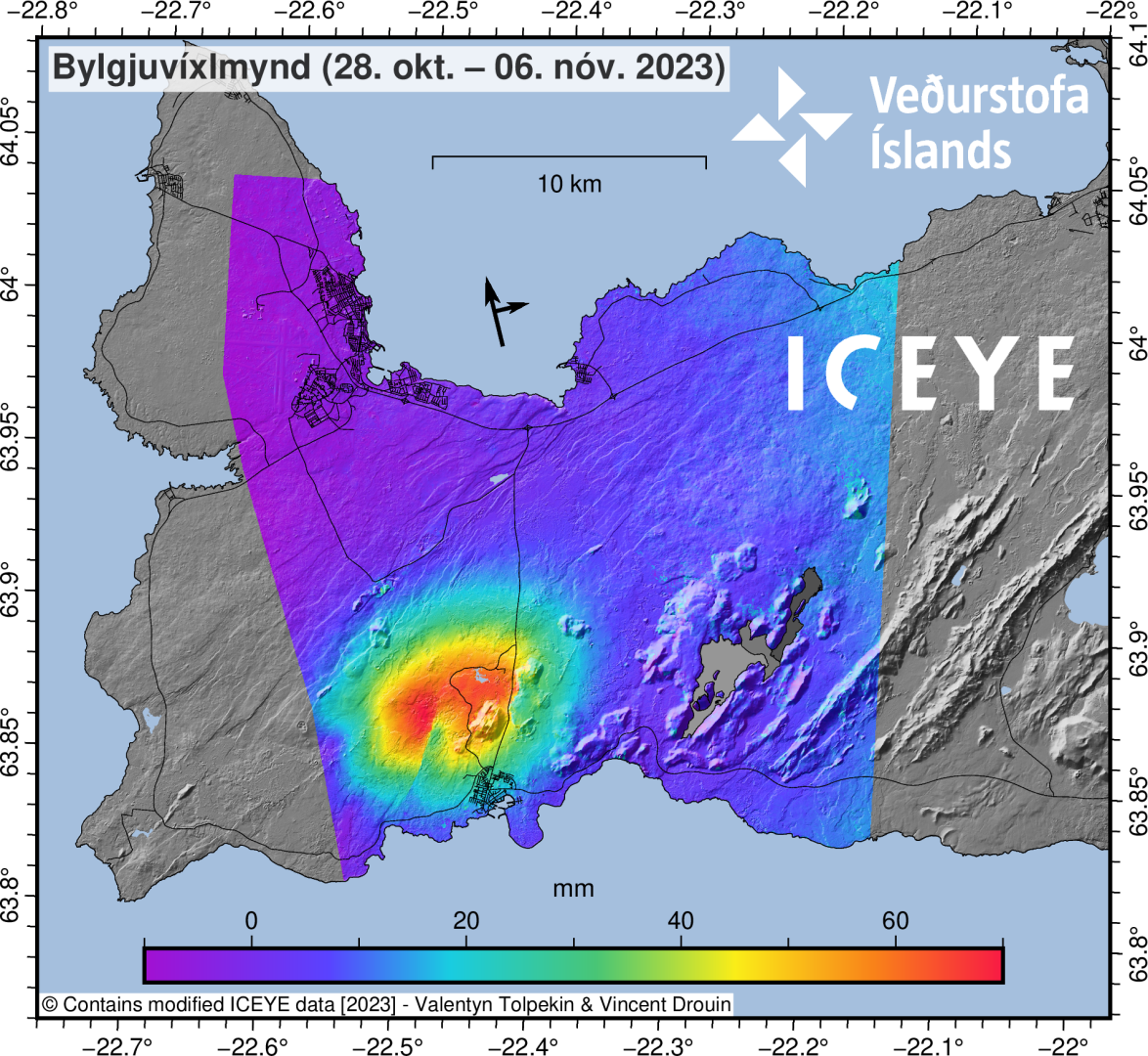
Interferogram (InSAR)
for the period 28th of October – 6th of November shows that deformation in that
period is around 7 cm. SW of Mt. Þorbjörn is an offset in the deformation
signal caused by fault movements by earthquakes.
Updated 7. November at 1:30pm
There have been around 900 earthquakes in the last 24 hours, most of them in the area between Þorbjörn and Sýlingafell. The largest earthquake was M2.9 and occurred around 7 am this morning. The seismic activity remains at the same depth as before.
According to satellite data processed around 5 pm yesterday and covers the period between November 4-6, confirms that uplift continues around Þorbjörn. The same data shows no signs of magma accumulation in Eldvörp or near Sýlingarfell, east of Svartsengi where seismic activity has been measued in recent days.
Magma accumulation continues at a depth of around 5 km in the are NW of Þorbjörn. If October 27th is considered the starting day of the inflation event until today, the rate of uplift has been fairly constant, although an acceleration of the process has been observed between days. It is likely that seismic activity will continue, and be episodic in intensity, while magma accumulation is ongoing.
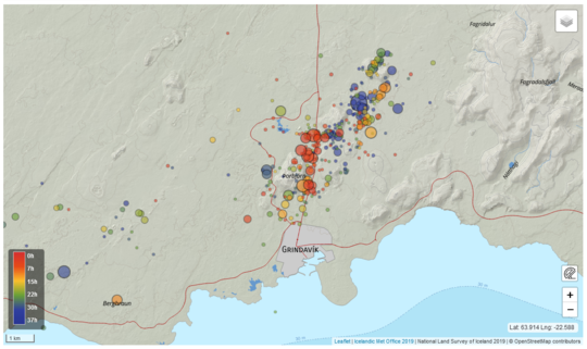
Reviewed earthquake locations since 6th of November and today until noon.
Updated 6. November at 1:15pm
In the last 24 hours around 1300 earthquakes have been detected on the Reykjanes peninsula, of which three earthquakes were above M3. The largest earthquake was M3.6 this morning and located 3 km NE of Mt. Þorbjörn.
Deformation data shows that uplift continues in the area and there are indications on GNSS observations of an increase in inflation rates since 3rd of November. Since the start of the inflation, the uplift at the GNSS station at Mt. Þorbjörn has reached 7 cm. The deformation is caused by a sill-type intrusion at around 5 km depth. Modelling, based on data since 27th of October, indicates that the volume change associated with this inflation event has reached almost two times the volume change associated with the four previous inflation events in the same area between 2020-2022. Inflow of magma/magmatic fluids into the sill-type body is estimated at approximately 7 m3/s which is about four times greater than the highest inflow estimated during previous inflation events here.
While the inflation continues,
increased seismicity in the area can be expected from additional stress changes
induced within the crust.
Updated 4. November at 11:30pm
After 17:30 yesterday, seismic activity decreased considerably. In the last 12 hours, about 900 earthquakes have been detected, all under M3.0. The activity after midnight as mainly been located at Sundhnjúkagígar - NE of Þorbjörn, as well as west of Eldvörp.
Seismicity has decreased considerably since yesterday, but the development of earthquake magnitudes, number of earthquakes and their location is comparable to the development previously seen related to magma accumulation in the vicinity of Þorbjörn.
The latest deformation data shows that uplift continues in the area. This uplift is thought to be due to magma accumulation NW of Þorbjörn at 4-5 km depth. While that magma accumulation continues, increased seismicity in the area can be expected from increased stresses in the crust. Rockfall can occur following large earthquakes, so caution should be taken by steep slopes.
The Icelandic Meteorological Office continues to monitor the area closely and to meet with the Civil protection agency to discuss the situation. Signs of magma coming towards the surface would appear as increased, shallower seismicity and rapid crustal deformation at the surface as well as volcanic tremor, which is a high rate of many small earthquakes. At the moment no clear signs can be seen of any of this, but the situation can change on short notice.
Earthquakes (circles) with magnitude over 1.5, from midnight on 3 November until 10:45 on the 4 November. The colour bar to the left shows the time of the earthquakes and the size of the circles represents the relative size of the events. Locations of seismic stations (triangles) and GPS deformation stations (squares) are also shown.
Updated 3. November at 3pm
An earthquake of
magnitude 4.3 was detected at 1:14 pm, today between Þorbjörn and Sýlingarfell.
Another earthquake of magnitude 3.5 was detected at 2:01 pm in Þorbjörn. These
earthquakes are thought to be due to continuing stress in the crust from magma accumulation
undir Þorbjörn mountain. No volcanic tremor has been detected and the area is
still being closely monitored.
Updated 3. November at 1:50pm
According to measurements from 11:00 am today, the uplift centered northwest of Þorbjörn continues. The uplift is caused by a magma intrusion at a depth of about 4 km. Seismic activity continues on the Reykjanes peninsula due to crustal stress changes caused by the intrusion. An increase in earthquake activity was detected after midnight and into the morning. Since midnight, around 1.000 earthquakes have been recorded in the area, with two being above M3.0 and two above M4.0. The biggest earthquake of the current swarm was measured at 8:06 am and was 4.3 in size. The biggest earthquakes last night seem to line up in a north-south direction west of Þorbjörn. This is happening on previously known fissures, where tension has been accumulating associated with plate tectonics and may curl due to tension from intrusions.
There are currently no clear signs of magma moving closer to the surface. Signs that magma is making its way to the surface would appear in shallower seismic activity and increasing tremor, which is a high frequency of small earthquakes. At the same time, sudden deformation of the surface should be measured with GPS measurements. The development of this event is closely monitored, as the course of events can change with very little notice.
Model calculations show that the intrusion is located northwest of Þorbjörn, as shown in the accompanying image. The most recent seismic activity has been over the intrusion itself. The earthquakes measured at Eldvörp and east of Grindavík road are due to tension from the magma intrusion by Þorbjörn, rather than signs of magma movements in those areas.

Approximate center of magma intrusion according to model calculations based on GPS and satellite images together with seismic activity from November 2nd at 8pm to November 3rd at 12pm larger that M1.0 in size. The model assumes a box-shaped intrusion, but its length and width are subject to quite a bit of uncertainty. The model will be frequently updated with the newest data once aquired, and the size and shape of the intrusion might change considerably, so there is quite some uncertainty to the model.
Updated 2. November at 3pm
GPS data from the last 24 hours indicate that uplift continues at a similar rate in the area northwest of Mt. Þorbjörn. Earthquake activity has been quite stable, but yesterday around 800 earthquakes were recorded in the area around Þorbjörn, and the largest was M3.7 at 12:56 am. Since midnight today, around 400 earthquakes have been recorded in the area, the largest measuring M2.8 at 9:51 am. More detailed analysis of recent GPS data confirms that a magma intrusion is forming at a depth of 4-5 km under the area northwest of Þorbjörn.
It is important to note that seismic activity is will likely continue northwest of Þorbjörn, and earthquakes over M4.0 could be found in populated areas. Triggered seismic activity can also be expected in the coming days because the magma intrusion causes increased tension in the area. Rockfall can occur following strong earthquakes, so it is important to be cautious on steep slopes.
Reviewed earthquakes from midnight November 1st until noon November 2nd.
Updated 1. November at 12:20pm
On 25 October, an intense earthquake swarm began near Svartsengi, north of Grindavík on the Reykjanes Peninsula. So far, over 10,500 earthquakes have been detected in the swarm, with over 26 earthquakes exceeding magnitude three, the largest of which was magnitude 4.5 on 25 October at 08:18 UTC.
The latest satellite radar image, acquired late on 31 October, reveals 5 to 6 cm of ground movements over 12 days, centered just northwest of Mt. Þorbjörn. The same displacement signal is seen in continuous GPS measurements from stations in the region, beginning on 27 October. The latest GPS results from 1 November indicate that ground displacements continue in the region. Combining seismic, geodetic, and satellite-based observations, we infer that a volcanic intrusion is located at about 4 km depth just northwest of Mt. Þorbjörn. Presently, there are no indications that the volcanic intrusion is becoming shallower. We expect that seismicity will continue northwest of Mt. Þorbjörn, and this could include felt earthquakes exceeding magnitude four. Triggered earthquake activity is also possible in the coming days due to stress increases caused by the intrusion. This is a likely explanation for the ongoing seismic activity detected west of Þorbjörn in Eldvörp on 1 November. Triggered seismicity is also possible due to the long-term effects of magma accumulation beneath Fagradalsfjall.
Updated 31st of October at 5pm
This morning at 8:40 am an earthquake swarm began at Þorbjörn, which lasted for almost 2 hours and was exceptionally intense. The largest earthquake in the swarm measured M3.7. The center of the activity was just east of the centre of the uplift observed in recent days. The depth of the earthquakes was estimated between 5 and 1.5 km depth. The earthquake swarm is a clear sign of magma movements at depth. GPS measurements support the interpretation, although the uplift that started about four days ago has slowed down. Earlier today, there was a meeting with Civil Defense and stakeholders on the Reykjanes Peninsula, where the latest measurements and possible scenarios and responses to the current scenario were discussed.
Situation closely monitored
IMO is monitoring closely developments and is looking to see if micro-seismic activity increases closer to the surface, which could be a sign that magma is breaking its way through the earth´s crust. Presently, there are no signs that earthquake activity is becoming shallower. However, the situation could change quickly, and it is not possible to exclude a scenario involving a lava-producing eruption in the area northwest of Þorbjörn. It is important to point out that magma movements, similar to that observed close to Þorbjörn, often fade away and do not lead to a volcanic eruption. Nevertheless, long-term rifting and increased (triggered) earthquake activity in the Svartsengi area could have created weaknesses in the crust, making it easier for magma to move to shallower depths.
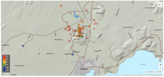
Reviewed earthquakes from midnight today.
Updated 30th of October at 11:30am
The Sentinel satellite data expected to be received yesterday has not arrived yet, however the cGPS data in the area around Svartensgi and Þorbjörn show that the deformation is still ongoing. The deformation rate since the beginning of this intrusive event has been slightly decreasing over time. Preliminary deformation model results suggest the average depth, where the magmatic instrusion is occurring, is about 4 km.
Over the past 24 hours about 1300 earthquakes have been automatically detected on the Reykjanes Peninsula. Most of this seismicity is located at a depth between 2-4 km. The largest earthquake had a magnitude M2.7 on the 29 October at 11:40UTC.
Scientists from the Icelandic Meteorological Office are undertaking additional surface measurements in the area, including geochemical observations. Regular communication is maintained between IMO, HS-Orka and the Civil Protection while this unrest continues.

8-hours solution for the cGNSS THOB station in Þorbjörn showing the latest data point updated at 08:00 UTC today
Updated 29th of October at 2pm
The latest cGPS deformation data around the Þorbjörn and Svartengi area confirm that the deformation, which started 27 October, continues. As initially stated, the ongoing deformation rates are higher than in previous events which occurred in a similar area in 2020 and 2022. Overall, the seismicity north of Grindavík has been declining over the past 24 hours and there are no significant changes in earthquake depths. However, it is important to emphasise that the current deformation may trigger renewed seismicity in the area that could be felt by people.
New satellite data are expected to be delivered later today, and a new interferogram will be processed as soon as the data are available. The results will allow us to identify and interpret the deformation processes that have occurred on the peninsula over the past 12 days. We expected to publish the results tomorrow.
An episode of complex volcano-tectonic unrest is currently affecting the
Reykjanes Peninsula. It is interpreted to result from multiple deformation sources
at depth, which are interacting and affecting a wide area across the peninsula.
Updated 28th of October at 1:30pm
The latest cGPS measurements, along with a newly acquired InSAR image over Reykjanes Peninsula, reveals a clear sign of ground uplift, centred around Svartsengi. This uplift signal began at some point on 27 October, and it reflects a pressure increase that is probably caused by a magmatic intrusion at depth. The centre of the uplift signal is around 1.5 km northwest of Þorbjörn, close to the Blue Lagoon. In 2020 and 2022, similar uplift signals were detected in the same area and with similar geometry. This is now the fifth inflation event in the area. From an initial assessment, the ongoing uplift signal is occurring more rapidly than before. Presently, there are no indications of magma moving at shallower depth. However, the situation may evolve rapidly. For instance, significant fracturing has occurred in the Svartsengi area due to triggered seismicity in recent days. Such fracturing could allow magma to find pathways to shallower depth.
Overall, the latest deformation results from the Reykjanes Peninsula show a complex, ongoing process of magma movements in the earth's crust. These processes are affecting a wide area, including Fagradalsfjall (where long-term inflation continues), east of Festarfjall (where the deformation seems to have stopped), and – in the last 24 hours – an area close to Svartsengi shows inflation.
The seismic swarm that began on 25 October north of Grindavík has resulted in over 7.000 earthquakes. The level of earthquake has reduced considerably, although the swarm is still ongoing, meaning that felt earthquakes are still likely.
Geophysical modelling is underway today to determine the depth and size of the uplift source close to Svartsengi. An additional satellite radar image will be available from Reykjanes Peninsula on 29 October. This image should provide an even closer insight into the recent magma movements and deformation pattens on the peninsula.
“Line-of-sight" (LOS) deformation measured by the ICEYE SAR satellite between the 26 October at 05:21 UTC and the 28 October at 05:21 UTC. Satellite data provided in collaboration with ICEYE (https://www.iceye.com/).
Updated 27th of October at 2pm
The ground-deformation signal detected since yesterday in the area East of Festarfjall is confirmed by the latest cGPS data. The horizontal displacement over the past few days is ~ 2 cm as seen at FEFC station and movement has now also been measured at another cGPS station located in Selatangar. A 1-day interferogram spanning 26 to 27 of October, does not reveal any significant changes in the area, but the signal at FEFC measured during this 24-hr period was smaller than 1 cm, likely too small to be detected by this interferogram. cGPS stations in Grindavík and north of here show no significant changes.
The seismic swarm north of Grindavík continues with around 1000 earthquakes since midnight. A total of 5800 eqs have been recorded since the beginning of the activity. An earthquakes M4.0 was measured at 04:02 UTC on 27 October around 2 km north of Grindavík. The seismic activity is interpreted as the response of the crust to the stress changes induced by continued magmatic inflow at depth beneath the Fagradalsfjall volcanic system.
Displacement at cGNSS station FEFC east of Festarfjall. Blue vertical line marks the onset of a dike intrusion in July 2023 and the red line the start an eruption near Litli-Hrútur 10th of July 2023. Most recent data points show up movement and horizontal movement towards SE.
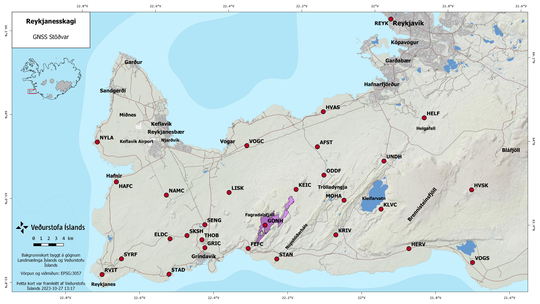
cGNSS stations at
Reykjanes Peninsula. Data from stations FEFC and STAN east of Festarfjall show
movement in the last day.
Updated: 26th of October at 5pm
The seismic swarm that commenced on 24 October continues. Over 4,000 earthquakes have been recorded on the Reykjanes Peninsula, of which 14 had a magnitude exceeding M3. Most of the activity has occurred between Stóra-Skogafell and North-East of Eldvörp. Seismicity is located between 2 and 6 km depth, with the largest earthquake (M4.5) measured on 25 October at 08:18 UTC. Scientists at the Icelandic Meteorological Office (IMO) interpret the ongoing seismic activity as triggered by stress induced by the ongoing deformation at Fagradalsfjall, which began soon after the summer 2023 eruption. The ongoing seismic swarm is expected to continue for the coming days. In the longer-term, the continued accumulation of magma beneath Fagradalsfjall could cause further seismic swarms on the peninsula.
Ground deformation measurements near Svartsengi and Grindavík show no changes related to the ongoing seismic swarm north of Grindavík. A single GPS station (FEFC), east of Festarfjall, is beginning to show localised movement in a south-east direction. These measurements could indicate the presence of magma at depth along the continuation of north-east – south-west-trending dyke intrusions, which have formed under Fagradalsfjall since 2021.
Staff from IMO continue to monitor the seismic unrest closely. In the coming days, satellite data will be used to better assess the spatial extent of any ground deformation. The measurements will also be used to better understand ongoing geophysical processes on the Reykjanes Peninsula.
Reviewed triggered earthquakes from October 20-26th.
Written 25th of October:
Last night an intense earthquake swarm started near Svartsengi, north of Grindavík. Over 1000 earthquakes have been detected there since midnight and the swarm is still ongoing. The largest earthquakes detected are M3.9 at 5:35 UTC and M4.5 at 8:18 UTC. Both of those earthquakes originated at around 5 km depth. Latest deformation data collected from several stations around the Þorbjörn/Grindavík area do not show significant changes correlated with the ongoing seismic activity. In light of the data currently available, this seismicity is interpreted to be likely triggered by the stress changes related to previous intrusive activity on the peninsula. There are currently no indications of magma migration beneath the Þorbjörn/Grindavík area, but the situation might change anytime, and it might evolve over a short time from hours to days. As reported in September a magmatic intrusion is currently ongoing beneath Fagradalsfjall.
Staff of IMO continues to monitor the area closely and interpret newest data as it becomes available.
Uncertainty level of Department of Civil Protection has been declared due to this seismic swarm.
8-hours solution for the cGNSS THOB station in Þorbjörn showing the latest data point updated at 08:00 UTC today.
Reviewed earthquake locations from midnight to noon on the 25th of October.
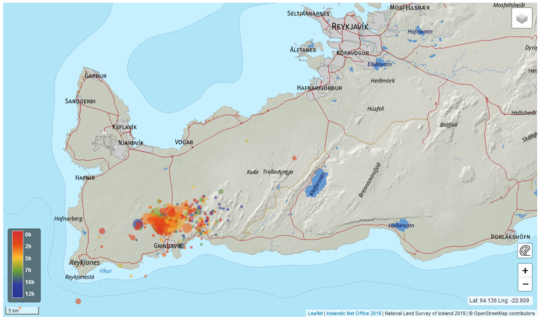 Automatic
locations of earthquakes from midnight to noon on the 25th of
October.
Automatic
locations of earthquakes from midnight to noon on the 25th of
October.


