

The weather in Iceland 2009
Climate summary
The weather was very favourable in Iceland in 2009.
Temperature
The temperature was well above the 1961 to 1990 mean. In Reykjavík it was the 10th warmest since the beginning of continuous observations in 1870. In Akureyri it was slightly colder, the year being the 31st warmest since 1882. All months, except two, were above the mean. The average temperature in Reykjavík was 5.6°C, 1.2°C above the 1961 to 1990 normal. In Akureyri the average was 4.1°C, 0.8°C above normal. In Stykkishólmur in the West the average was 4.7°C, 1.2°C above the normal.
Average temperatures at individual stations and ranking (1 = warmest, 3 = third warmest etc.).
| station | temperature | anomaly | rank | of |
| Reykjavík (SW) | 5.55 | 1.24 | 10 | 139 |
| Stykkishólmur (W) | 4.70 | 1.22 | 14 | 165 |
| Bolungarvík (NW) | 3.87 | 0.93 | 20 | 113 |
| Grímsey (N) | 3.69 | 1.25 | 10 | 136 |
| Akureyri (N) | 4.06 | 0.77 | 31 | 129 |
| Grímsstaðir (NE) | 1.62 | 1.12 | 20 | 103 |
| Egilsstaðir (E) | 3.92 | 0.98 | 17 | 60 |
| Dalatangi (E) | 5.02 | 1.29 | 4 | 72 |
| Teigarhorn (E) | 4.89 | 1.17 | 10 | 137 |
| Höfn í Hornaf. (SE) | 5.61 | 1.07 | ||
| Fagurhólsmýri (SE) | 5.85 | 1.24 | 3 | 112 |
| Stórhöfði (S) | 6.02 | 1.21 | 8 | 133 |
| Hveravellir (Central Higland) | 0.28 | 1.37 | 6 | 44 |
| Eyrarbakki (S) | 5.30 | 1.23 | 12 | 114 |
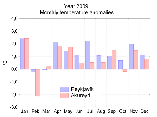
This was the 11th year in a row with the temperature above the mean 1961 to 1990 in Akureyri and the 14th consecutive year above in Reykjavík. In Reykjavík, it was the 9th consecutive year above the mean for the slightly warmer period 1931 to 1960. Such a long run with above mean temperatures is unique in the record.
The highest maximum temperature of the year was 26.3°C, measured at Egilsstaðir in the Eastern inland on June 29 and at Torfur in the Northern inland on July 1.
The absolute minimum of the year was recorded at Svartárkot in the Northern inland on February 12, -29.0°C.
Precipitation
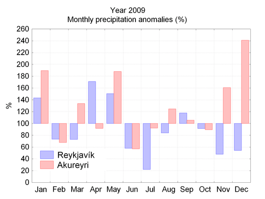
The total precipitation of 2009 in Reykjavík was 713 mm, which is about 10% below the 1961 to 1990 mean. This was the driest year in Reykjavík since 1995. The first part of the summer was unusually dry in Reykjavík and in most of the South and West. The total precipitation in Akureyri was 652 mm, which is more than 30% above the 1961 to 1990 mean. This is the largest annual precipitation in Akureyri since 1991. December was particularly snowy in Akureyri as the precipitation total in that month has never been so high, continuous measurements started in 1927.
The largest 24-hour total at a manned station was measured at Hólar in the Southeast on 10th October, 180.6 mm. In the automatic network the largest 24-hour total was measured at Eskifjörður in the East on 10th October, 185.3 mm.
Snow
Generally, the year had light snowfalls; the largest depth measured was at Mýri in the Northern inland on 18 January, 166 cm.
The ground was totally covered by snow for 40 days in Reykjavík; this is 25 days below the long term mean. In Akureyri the ground was totally covered by snow for 97 days, 20 days below the long term mean.
Precipitation days
Precipitation was registered on 205 days in Reykjavík, 16 days below the 1961 to 1990 average. In Akureyri the precipitation days were 201, 31 above the long-term average.
Sunshine duration
Bright sunshine was recorded for 1490 hours in Reykjavík, 200 hours above the 1961 to 1990 average. This is the tenth consecutive year with the number of bright sunshine hours above average. The cloud cover in Reykjavík was below average. In Akureyri bright sunshine was measured for 1050 hours, very close to the average.
Prevalent winds
Easterly winds were more prevalent than in any year since 1985. The north-to-south pressure gradient was also stronger than average. The sea level pressure was slightly below average.
Windstorms
Damaging windstorms were unusually few during 2009 and the frequency considerably below average. The worst widespread windstorm occurred during 9th and 10th October.
A brief overview of the seasonal weather
January was warm and wet; the first part of the month was particularly warm. The first part of February was very cold, but the weather was calm and rather favourable. This was a very dry period in most of the country. By the middle of the month the weather became much warmer with heavy precipitation in the South.
March was close to the 1961 to 1990 average. Windstorms were few, but snow and drifting snow influenced traffic conditions, especially late in the month in the North. Avalanche danger was persistent in the North-western fjords during the first week of the month and in the North during the last part of the month.
The spring (April and May)
April was warm and snow cover was considerably below the normal. The precipitation was above the normal in most districts and it was particularly wet in the Southeast. The weather was windy. A new total precipitation record for April was reached at Kvísker in the Southeast, 523,7 mm. May was warm, rather wet and windy.
The summer (June to September)
June was favourable, temperatures were above the normal in the entire country, precipitation was below normal. It was unusually calm, the calmest June since 1963 and the average sea level pressure was unusually high. July was mainly warm and dry, the temperatures above normal, except in a small area of the Eastern inland. In the west the vegetation suffered in the dry weather. This was the driest July in Reykjavík since 1889. During the last days of July a severe cold spell hit the country for a few days, there was snow in the northern highlands and the southern lowlands experienced night frosts which caused large damage in the potato fields, reducing the harvest by up to 80% in places.
August was rather warm, it was sunny in the South and West, but the North and East were rather gloomy and the precipitation was above normal in that part of the country. September was mainly calm and warm. The precipitation was slightly above normal. The summer was warm in Reykjavík, ranking in the tenth place since 1871.
The last part of the year
The temperature was close to the average. A cold spell hit during the first week with slight snow in most districts. The remaining part of the month was warm. A very strong windstorm hit on 9th and 10th October with slight damages, mainly in the vicinity of Reykjavík.
November was rather warm and favourable. The first part of December was very warm, but just before Christmas the weather got colder. The last week of the year was very cold. There was unusually much snow in the central part of the North, but only slight snow in other districts. Akureyri reached a new snow depth record for December, 90 cm.
Documents
This article, The weather in Iceland 2009, can be read here in pdf (0.3 Mb)


