
The weather in Iceland 2011
Climate summary
The year 2011 was warm and the weather mainly favourable in Iceland except for a bad cold spell in late May and June. The northeast was hardest hit by the cold spell. Another cold spell hit in early December. April and November were unusually warm. At a few stations in the east and northern coastal areas April was warmer than June. This has not happened before in Iceland at any station since the beginning of instrumental recording.
Temperature
The average temperature of 2011 in Reykjavík was 5.4 °C, 1.1 °C above the 1961 to 1990 mean. This is the 16th consecutive year of above normal temperature in Reykjavík. The temperature was above normal during ten of the months, November being the warmest. December was the coldest month of the year. In Stykkishólmur in the west the average was 4.5°C, 1.0°C above the mean and the year ranks as the 20th warmest since 1845.
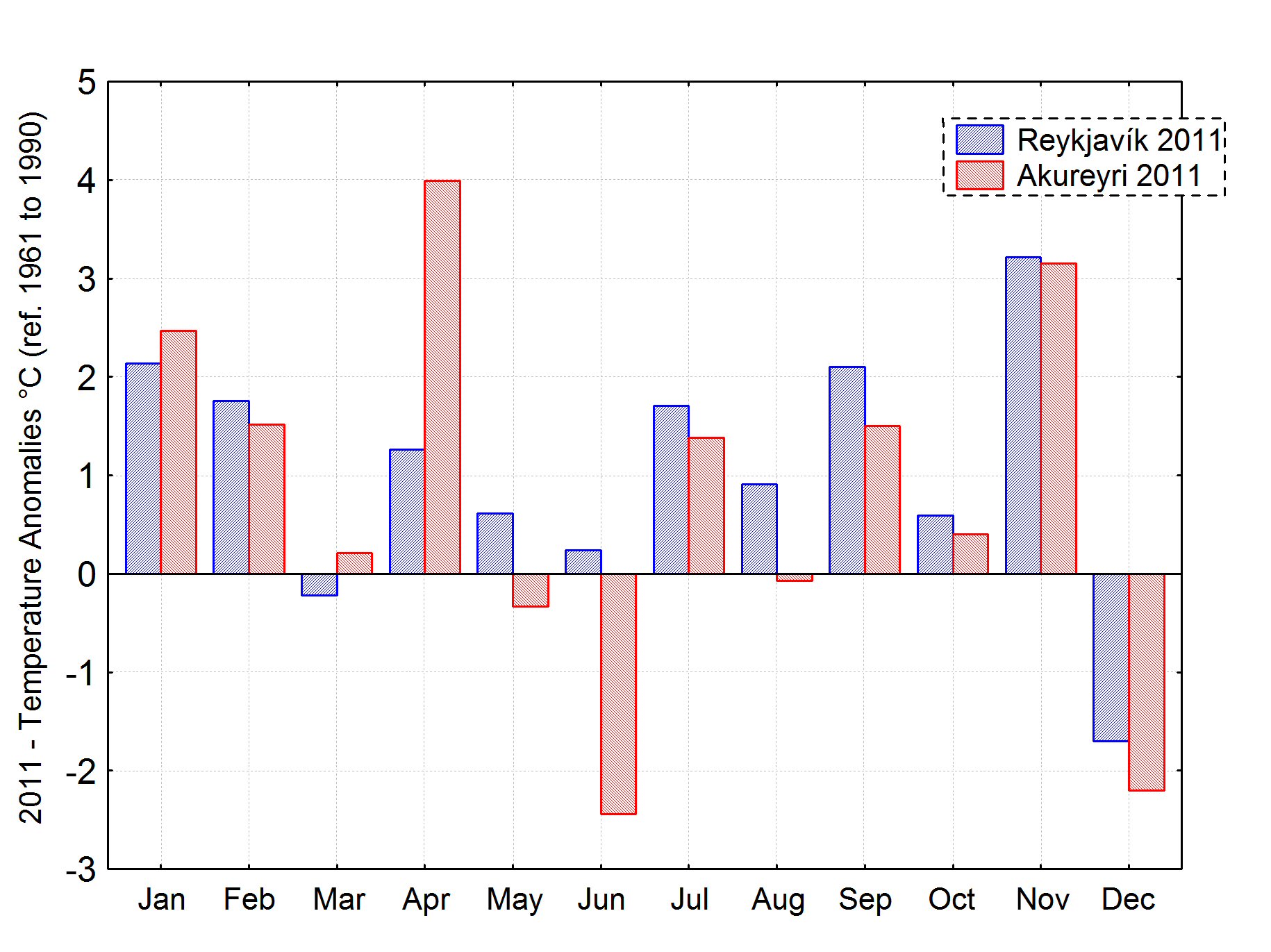 Monthly temperature anomalies (°C) in Reykjavík (blue) and Akureyri (red) 2011. Reference period: 1961 to 1990.
The absolute maximum and minimum temperatures of the year
The maximum temperature recorded in 2011 in the whole country was 24.8°C, measured at Húsavík in the north on 27 July. This is slightly lower than the average annual absolute maximum in Iceland. The minimum temperature was -27.8 degrees at Upptyppingar in the northeastern inland on 8 December, close to the average annual absolute minimum in Iceland.
Precipitation
The precipitation was above normal. In Reykjavík it exceeded the 1961 to 1990 mean by about 13%. April was the wettest with more than the double normal amount. June and August were the driest. At Akureyri in the north the precipitation was about 30% above the mean. In the east the exceedance was even larger, up to 45% at Dalatangi, but not an absolute record. The largest 24-hr precipitation of the year was measured at Kvísker in the southeast, 135.5 mm on 3 July. The number of days with precipitation was considerably higher than the normal in most of the country. Days with precipitation exceeding 1.0 mm were 174 in Reykjavík, 26 more than during an average year.
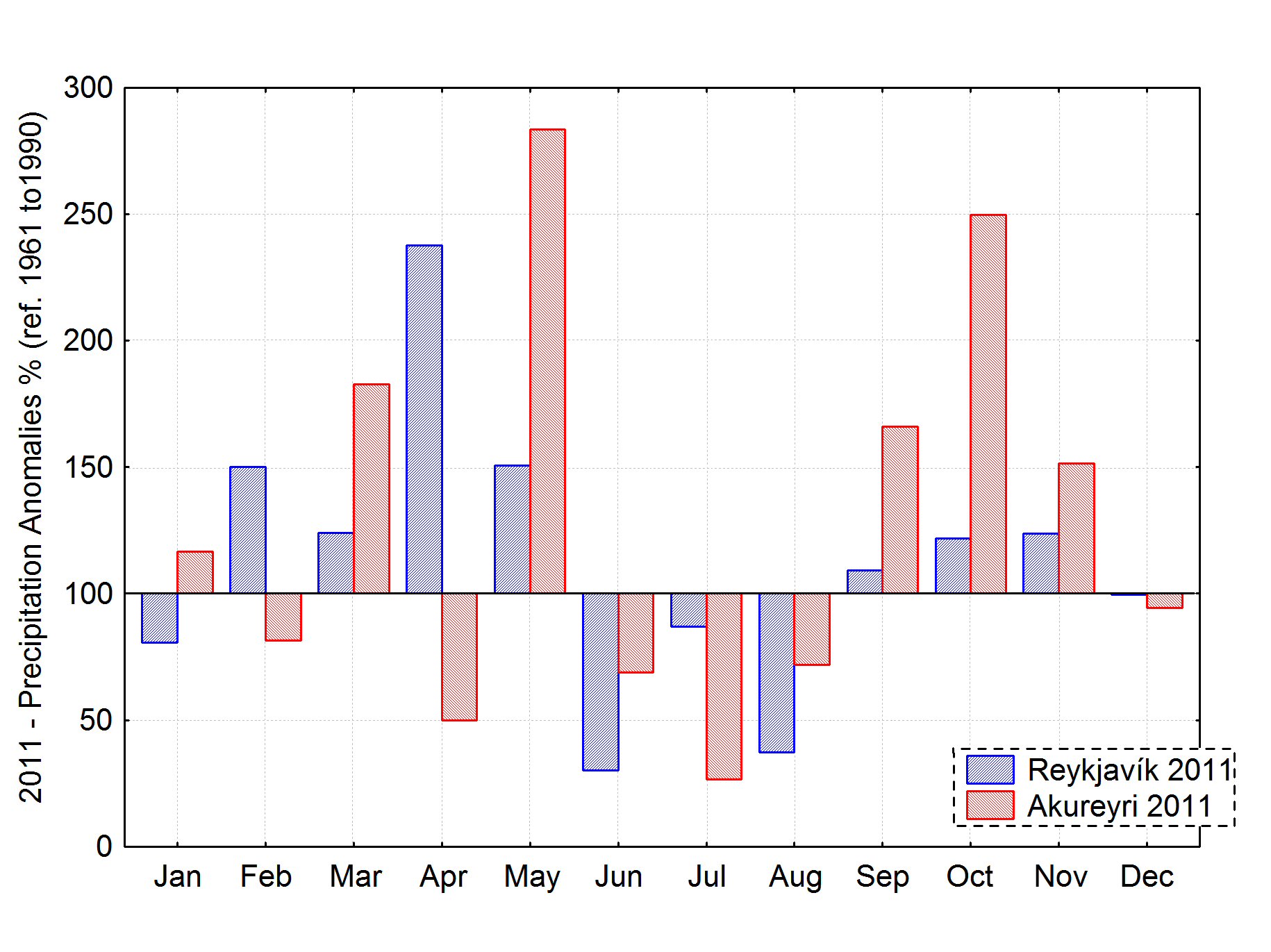 Monthly precipitation anomalies (%) in Reykjavík (blue) and Akureyri (red). Reference period: 1961 to 1990.
Snow
There was not much snow during the winter of 2010 to 2011. Snow covered the ground completely only on 2 days in January in Reykjavík. On the other hand, December had unusually much snow in Reykjavík. The ground was completely covered by snow for a total of 29 days. In Akureyri in the north there was not much snow either during the first months of 2011, but the ground was covered by snow during the whole of December, for the first time since 1996.
Bright sunshine
There were 1465 hours of bright sunshine in Reykjavík during 2011, 196 more than in an average year. This is the twelfth consequtive year of above average sunshine in Reykjavík. In Akureyri the number of bright sunshine hours was 979.4 or 66 hours below average, but well above the absolute annual minimum.
Sea level pressure
There was a remarkable contrast in pressure between the years 2010 and 2011. During the earlier year the pressure was the highest since the start of observations in 1823, but in 2011 it was among the lowest during the same period. The average sea level pressure in Reykjavík during 2011 was 1001.0 hPa, 4.9 hPa below the long term mean, and ranks as the third lowest since the beginning of observations in 1823, slightly higher than 1990 and 1868 and on par with 1989 and 1863. The highest sea level pressure of the year was measured at Dalatangi in the east on 5 March, 1037.3 hPa, but the lowest at Eyrarbakki in the southwest on 24 desember, 948.4 hPa.
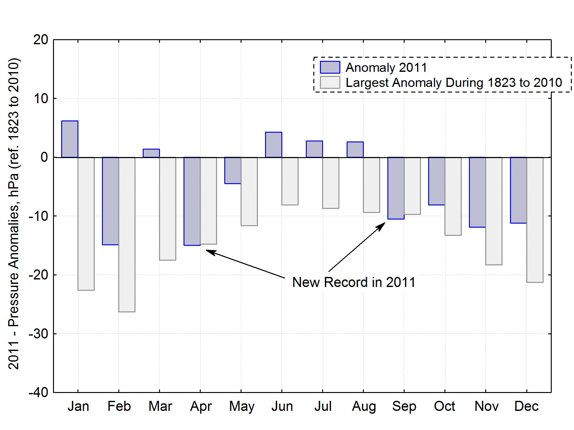 Monthly sea level pressure anomalies in Reykjavík (blue), largest anomalies of the entire reference period, 1823 to 2010 plotted in gray. The average pressure in April and September has never before been as low as in 2011.
Wind speed
The average wind speed at all manned stations was the highest since 1993. April was particularly windy. Windstorms reaching the whole country were few, but local wind damage occurred on a number of occasions. The highest 10-minute wind speed was measured at Jökulheimar in the central inland on 11 February, 46.9 m/s. The highest gust was measured at Gagnheiði 22 December, 60.1 m/s.
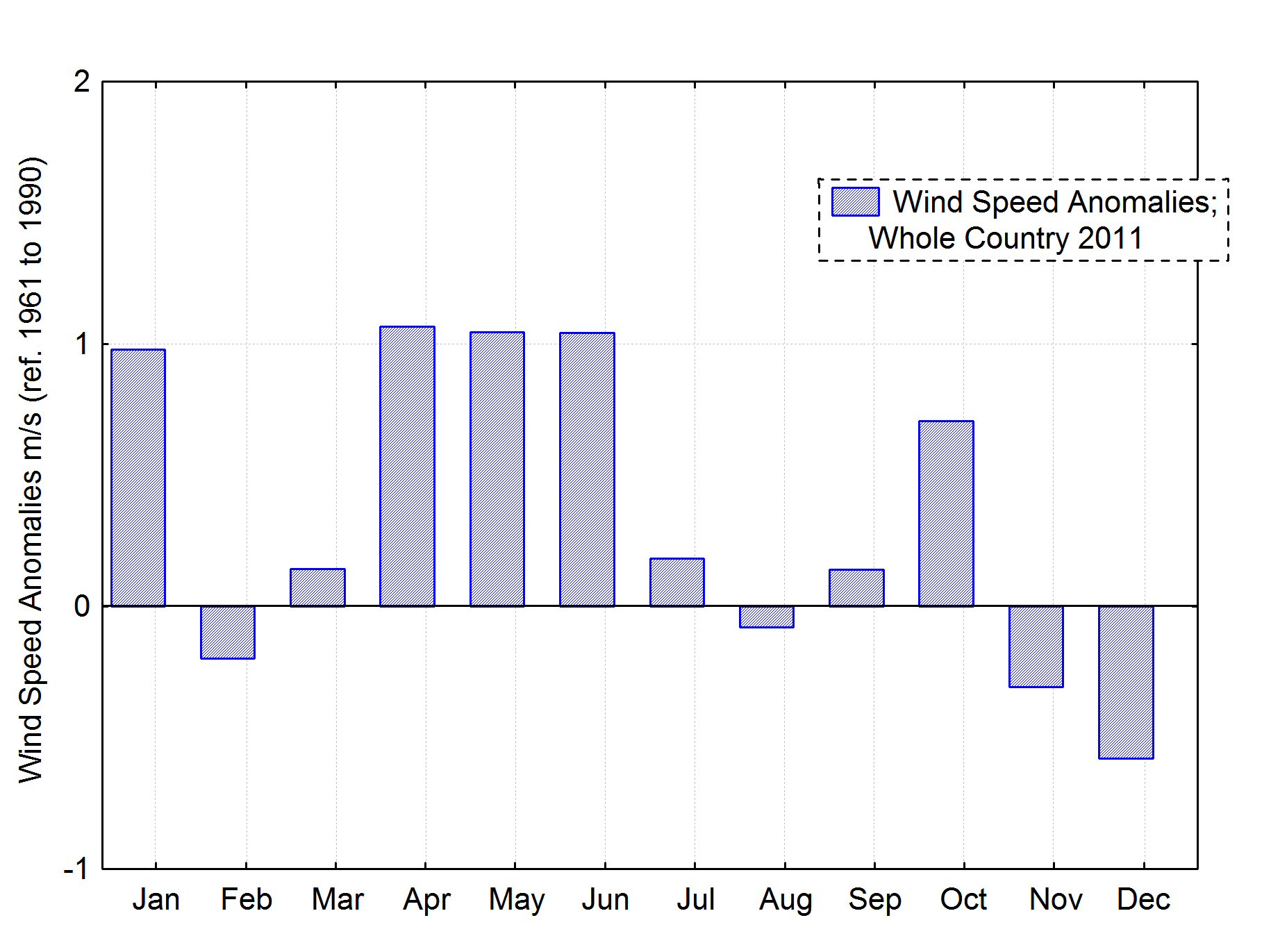 Monthly wind speed anomalies (m/s) in 2011. All synoptic weather stations. Reference period: 1961 to 1990.
Wind direction
The prevalent wind direction was close to average during the year as a whole but individual months were highly anomalous. Southerly winds were much more prevalent than on the average in April and northerly winds unusually prevalent in June.
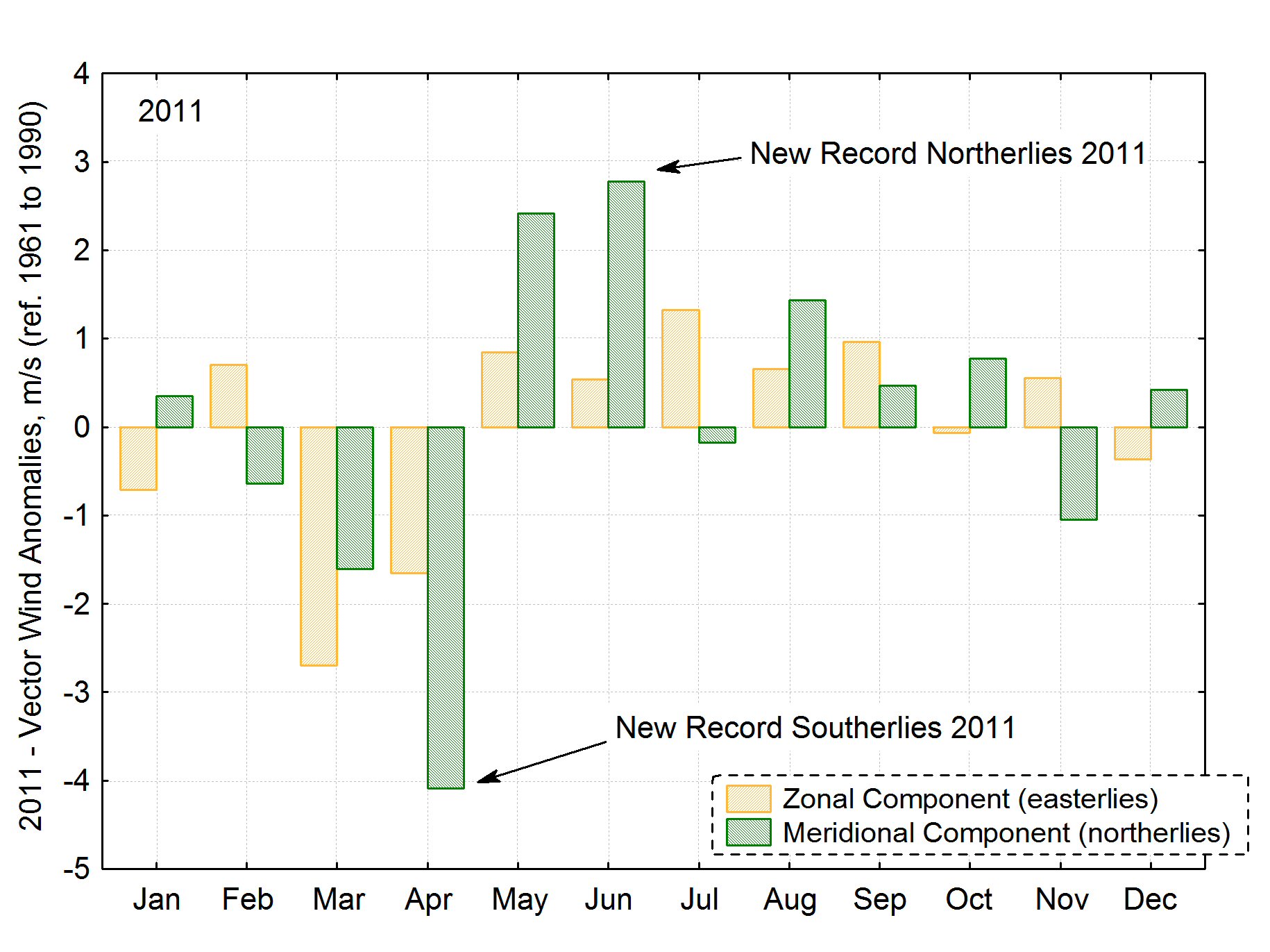 Vector wind anomalies (all synoptic stations). On the whole the year was close to the average but individual months had large deviations from the mean (1961 to 1990). April had a large southerly anomaly but in both May and June northerly winds were much more common than during the reference period.
A short monthly summary
January
January was warm. It was dry in the south and southeast but in other parts of the country the precipitation was above normal. There was a northerly storm on the 6 and 7 which caused some damage. There were frequent communication disruptions during snowstorms in the north and east during the first part of the month and dry and wet avalanches caused minor damages.
February
February was warm and windy and minor damages occurred during some of the windstorms.
March
The weather was very unsettled and in the west it was considered to be unfavourable. Precipitation was heavier than the average. There was more snow in the south and west in March than since the year 2000.
April
April was very warm, in the east it was one of the warmest in the record. At Teigarhorn in the east it was the second warmest since the start of measurements in 1873. The month was very windy and the precipitation in the south and west was heavy. There was only one dry day in Reykjavík. Snow cover was far below the normal. The monthly average pressure was the lowest in the record. The month was rather windy and wind damage occurred on a few days.
May
The first third of the month was unusually warm and in the second third the temperature remained above average. The last third was particularly cold. The northern and northeastern parts of the country were hit by an unseasonal snowstorm on 23 and 24. This caused communication breakdowns, even in the lowland. The precipiation was heavy in the east and earlier total records were exceeded at a few stations.
June
June was cold, especially in the northeast and in the eastern inland, being the coldest June for almost 60 years in that part of the country. The temperature in the southwest was close to the average. The month was very dry in the south, west and most of the north, but the precipitation was heavy in the east. The ground was covered by snow during a few days at higher habitated areas in the northeast during the first half of the month.
July
In contrast to June July was rather warm, especially in the northwest. The north was dry.
August
August was a favourable month, the temperature was above the normal, except in a small area in the east. It was very dry in the west and dry in most parts of the country.
September
September was warm in the whole country. It was wet in the southeast and also in the southwest during the last week of the month. The average pressure was the lowest ever in September, since measurements started in 1822.
October
October was warm, warmest in the east. The precipitation was above normal.
November
November was unusually warm, one of the warmest on record even though the last days were cold. Precipitation was above normal and there was little snow.
December
The first half of the month was unusually cold, but the second part was close to the average. Snow was unusually prevalent, covering the ground completely in Reykjavík for 29 days of the month. The snow cover has has never been so long-lasting in December before. The snow cover has been observed in Reykjavík since 1921. A large part of the snow turned to ice during the second half of the month. This resulted in extraordinary slippery ground and a large excess of fall related accidents.
This article, The weather in Iceland 2011, can be read here in pdf (0.3 MB)


