

The weather in Iceland 2012
Climate summary
Introduction
On the whole the year was a favorable one. However, the first three months were dominated by very changeable and windy weather and southerly and westerly winds that eventually became quite mild. A few damaging windstorms hit the country. September and November were dominated by unfavorable weather. At the beginning of April there was a marked change and most of the remaining parts of the year northerly winds were prevalent. Except for a few severe northerly storms the weather remained rather mild.
The spring and summer were unusually dry and sunny in both the western and northern parts of the country. In some areas the vegetation suffered by drought and there were local water supply problems in a few places.
The northern and northeastern part of the country was hit by an unseasonal and severe snowstorm in early September. In the area, farmers lost thousands of sheep in spite of extensive effort to salvage this livestock, which was due to be hearded from the summer pastures a few days later. Icing on power supply lines led to considerable damage and power outages in the area as well as traffic disruptions.
The weather during the first two weeks of November was very stormy and there were unseasonably large snowfalls in the North. A particularly fierce northerly windstorm raged almost unabated during the first four days of the month and caused the most extensive wind damage in the country for at least the last 6 years. A severe northeasterly storm hit the western and northern parts of the country between Christmas and New Year. Power supplies and communication were hit heavily for a few days. Many residential and industrial buildings had to be evacuated for a few days due to a threat of avalanches, which hit several structures but the damage was minimal, without doubt because of the large mitigating effort which has been ongoing for the last 17 years.
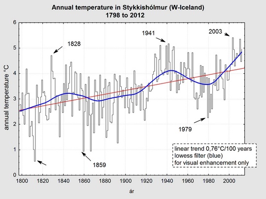
Temperature
The year was warm, especially in the western part of the country. In Stykkishólmur in the west it was the seventh warmest year since the official start of observations in 1845. There and in Reykjavik it was the 17th in an unbroken sequence of above normal [1961 to 1990] annual temperatures, and the 14th such year at Akureyri in the north.
The average temperature in Reykjavík was 5.5°C, 1.2°C above the 1961 to 1990 mean. In Akureyri the average was 4.3°C, 1.1°C above the mean. The first three months of the year were particularly warm as were July and August. No month was cold. At the individual stations Surtsey off the southern coast had the highest annual mean temperature, 6.8°C. The lowest annual mean was measured at Brúarjökull, on the lowest part of a glacier in the east, -2.1°C. The lowest annual mean in the inhabited areas was measured at Möðrudalur in the northeastern inland, +1.1°C.
The absolute maximum temperature of the year, 28.0°C, was measured at Eskifjörður in the Eastern Fjordland on August 9, the lowest minimum measured during the year was -25.7°C at Brúarjökull on April 2, and the -24.7°C measured at the farm at Svartárkot in the northern uplands on December 25 was the lowest minimum in inhabited areas.
The lowest minimum of the year measured in Reykjavík was -7.9°C, on January 3. This is the highest ever annual value of the minimum temperature in Reykjavík.
Precipitation
The annual precipitation was slightly above the 1961 to 1990 average in most parts of the country. The annual total in Reykjavík was 951 mm, about 19% above the long term mean. The first three months of the year were very wet. September was also wet, but the period May, June and July was unusually dry. In the north both September and November had unusually much precipitation and in November much of the precipitation fell as snow in the north.
At Stykkishólmur in the west June was the driest ever, the observations started in 1856. And the three months, June to August were the driest there since 1915.
The annual maximum 24-hr precipitation in the country was 125.0 mm, recorded at Nesjavellir, about 40 km east of Reykjavík.
Snow
The winter of 2011 to 2012 had early heavy snow and the winter as a whole saw 73 days with snow cover (100%) in Reykjavík, 8 days more than the 1971 to 2000 average. During the last part of the winter the snow conditions were unusually light in the north, resulting in the winter total of 77 snow cover days in Akureyri, 41 day less than the average.
The first part of the winter 2012 to 2013 had a very light snow cover in the south but the snow cover was unusually heavy in the north. During the year as a whole, snow cover days in Reykjavík were 49, 16 days less than the average. In Akureyri the number of snow cover days was 95, 22 days less than the annual average.
Bright sunshine
The year 2012 was one of the sunniest on record both in northern and southwestern Iceland. Akureyri measured bright sunshine during 1415 hours, a new record, and exceeding the old by 140 hours. In Reykjavík the number of sunshine hours was 1587. This is the second highest annual total since the measurements started in 1911, only exceeded by the year 1924.
Sea level pressure
The average sea level pressure in Reykjavík was 1007.4 hPa, 1.5 hPa higher than the 1961 to 1990 mean. The highest pressure measured in the country during the whole year was 1039.0 hPa and the lowest reading was 947.3 hPa.
Wind speed
Wind speed was close to the average for the whole year. October had particularly light winds.
A few bad windstorms hit the country. There was more total damage than during storms in recent years. The most extensive windstorms were: January 10 (wind from the west), February 7 (wind from the south), May 13 (from the north), September 10 (from the north), November 1 til 3 (from the north), November 9 to 10 (from the northeast and north) and December 29 (from the northeast). The first November windstorm was the most extensive one; the damage was generally mainly wind-related. However, salt deposition on transformers caused heavy electrical disruption both in the January and November storms. Icing caused much damage on the electrical supply lines both in September (NE-part of the country) and December (NW-part of the country). The livestock death in the September storm has already been mentioned.

Wind direction
During the first three months of the year, winds from the south and west prevailed, more than the long-term average. After that northerly winds prevailed, winds from the east were particularly common in December.
A short month-by-month overview
January
This was a month of windy and changeable weather. In the Southwest and Northwest there was heavy snow. Short-lasting thaws were common so much of the snow turned to ice, causing excessively slippery roads and pavements which made ordinary daily outside chores very difficult. The temperature was above the mean and the precipitation was heavy, in the southwest close to record amounts or exceeding them at a few stations.
February
The weather remained very unsettled during the whole month which was very warm all over the country. Precipitation was heavy in the south and west and at a few stations previous record amounts were exceeded. There were 28 days with measurable precipitation in Reykjavík. Snow cover was light as most of the lowland snow of December and January melted during this warm period.
March
March was very warm, especially in the north and east. It was very wet in the south and east and snow cover was light all over the country. The weather was very changeable. On the 29th a new absolute maximum temperature record for March was reached for Iceland at the station Kvísker in the southeast. The new record is 20,5°C.
April
April was a favorable month, but rather cold at the East coast. It was very dry in the south. April was colder than March in the whole north and east. This state of affairs is unusual. The snow cover was light.
May
The first two days were warm, as was the last week. In between, there was a severe cold spell with heavy snow in the east. In the warm spell during the last week the maximum temperature in the country reached 20°C for six consecutive days. This is highly unusual in May. There was unusually much sunshine.
June
June was warm in the west but rather cold in the east. It was very dry; precipitation was below the long term mean all over the country. The drought was unusual in the western and northwestern part of the country. This is the driest June in Stykkishólmur since the start of observations in 1856, the total precipitation during the whole month was only 0,6 mm. The wind speed was below average.
July
July was very warm in the southwest and west and the temperature was above the 1961 to 1990 mean in the whole country. Precipitation was below the mean, but it was not quite as dry as in June. The number of sunshine hours was high. Winds were light.
A remarkably deep low developed to the southwest of Iceland on 19 and 20 July 2012. According to the analysis of the ECMWF the central pressure in the low dropped to 966 hPa. This is amongst the lowest values ever observed in the North Atlantic in July.
After the low reached its maximum intensity it moved towards Iceland and filled gradually. Sunday evening 22 July the pressure was at minimum near the south coast of Iceland. The lowest mercury barometer reading was 972.8 hPa, first at Vestmannaeyjar at 21 pm and then again at Kirkjubæjarklaustur 6 hours later. The lowest value at an automatic station was reached in Vestmannaeyjar during an extended period of one hour, 21:30 to 22:30, 972.4 hPa.
The pressure in Iceland has only on three occasions dropped down to 975 hPa or lower in the entire record extending back to the 1820s. These cases were 974.1 hPa in Stykkishólmur on 18 July 1901, 974.3 hPa in Stykkishólmur on 19 July 1923 and 975.0 hPa in Reykjavík 11 July 1912. It should be kept in mind that even though the pressure was recorded at a few stations all over the country during the period from 1874 onwards, longer intervals passed between readings than now. Three readings per day were typical, but eight readings have been made at most of the barometric stations since the mid-1940s.
August
August was warm in the whole country. It was unusually dry in the north. The period June to August has never been so dry in Akureyri since the beginning of continuous measurements in 1928, but earlier measurements at nearby sites indicate that the summers of 1915 and 1916 might have been as dry as this one. An unprecedented run of 23 consecutive days with country maximum temperature over 20°C ended on August 18.
September
The weather was unfavorable and unsettled. The outstanding event was the great snowstorm in the north and northeast during the 9th to 11th of the month. Snowdrifts up to 2 meters were observed at inland farms which is very unusual so early in the season. Thousands of sheep perished and the electrical grid suffered large damages due to icing. The month was very wet in the north – amongst the wettest on record. This contrasts remarkably to the preceding dry spell that had lasted in the area since May.
October
October was a favorable month, with light snow cover. Temperatures were close to the normal. The average wind speed over the whole country was the lowest in October since 1960.
November
The first three weeks were very unfavorable. There was unseasonably much snow in the north and the precipitation totals in the northeastern inlands were above the record maxima for November. Windstorms were common, the worst have already been mentioned above.
December
The weather was favorable until Christmas. There was a bad snowstorm during the last days of the year in the northern and northwestern part of the country with both severe communication disruptions as well as loss of electricity in both towns and rural areas. The temperature was above normal.
Additional material
This article, The weather in Iceland 2012, can be read here in pdf (0.3 Mb)


