
Eyjafjallajökull eruption 2010 - the role of IMO
Sigrún Karlsdóttir, Guðrún Nína Petersen, Halldór Björnsson, Halldór Pétursson, Hróbjartur Þorsteinsson, Þórður Arason
The Icelandic Meteorological Office (IMO) is responsible for monitoring and issuing forecast and warnings of natural hazards to the civil protection agency, aviation service provider and the public. One of the main strength of the institute is that it covers the fields of meteorology, hydrology and seismology, all of which interact when it comes to natural hazards such as volcanic eruptions (e.g. Vogfjörð et al., 2005)*.
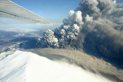
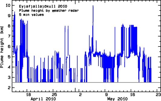
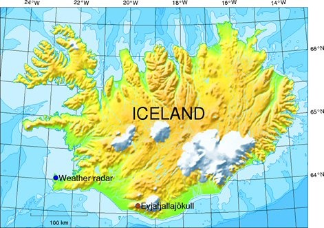
During the ice capped Eyjafjallajökull volcanic eruption in April-May 2010, IMO monitored the volcanic activity through various geophysical sensors (seismic, strain, GPS), river runoff from the glacier and the behaviour of the volcanic eruption cloud (see slide show). The main tool for monitoring the volcanic cloud was a C-band weather radar located at Keflavik international airport, approximately 150 km west of the volcano (see map below).
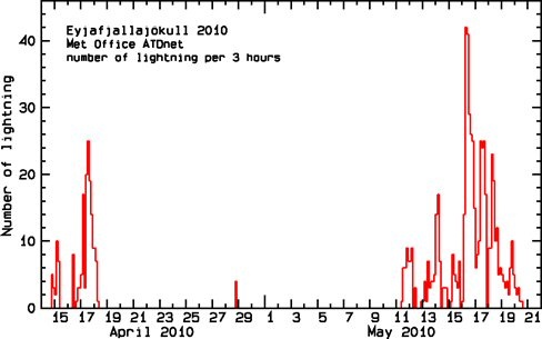
Radar monitoring of the plume height was supported by visual observations, on-site and from a network of web-cameras. Airborne observations allowed for detailed examination of the plume, and pilot reports proved to be an extremely useful aid in verifying the radar data. Furthermore, data from lightning sensors and radiosondes was used to supplement information on plume height. Satellite images, from several frequency bands and both polar as well as geostationary satellites were used to track the orientation of the eruption cloud, and brightness temperature difference was used to estimate ash dispersal. Ash fall monitoring and meteorological observations supplemented with reanalysis and wind forecasts were used to track local ash dispersal.
The data generated by these different observation types gives a consistent picture of the progression of the eruption and reveals interesting connections. For example, the occurrence of lightning seems to be explained by both sufficiently strong plume and cold ambient air. Wind also had a clear effect on the eruption cloud height. In general, simple scaling laws for the relationship between the emission rate of the volcano, and the height of the eruption do not seem to explain all the height variations in the eruption cloud.
The effects of ash on aviation have been known for several decades. For better preparedness, regular exercises have taken place between IMO, London VAAC and ISAVIA during the past six years. Larger exercises involving EUROCONTROL and Toulouse VAAC have been conducted as well. Improvements in the contingency plans took place during this period; however, a great step forward was taken during the Eyjafjallajökull eruption. For instance, a volcanic ash status report on the plume activity was issued every 3 hr, to London VAAC and other sister institutes in Europe and North America. The reporting process was governed by the quality control system at IMO. In addition a joint daily report was issued from scientists at IMO and the Institute of Earth Sciences, University in Iceland.
Several activities are planned to improve meteorological-, seismic- and hydrological monitoring around volcanic areas in Iceland. In addition several research activities have started or are planned which aim to improve our understanding of the volcanic behaviour, plume activity and interaction between plume and weather.
For further information, a slide show from a lecture on the subject (pdf 1.4 Mb) is available. Also, other articles on the Eyjafjallajökull eruption 2010 can be read on our web-site as well as the then current news on the subject.
Reference
* Vogfjörð K., Jakobsdóttir S.S., Guðmundsson G.B., Roberts M.J., Ágústsson K., Arason T., Geirsson H., Karlsdóttir S., Hjaltadóttir S., Ólafsdóttir U., Thorbjarnardóttir B., Skaftadóttir T., Sturkell E., Jónasdóttir E.B., Hafsteinsson G., Sveinbjörnsson H., Stefánsson R., and Jónsson T.V., 2005, Forecasting and Monitoring a Subglacial Eruption in Iceland, Eos, Vol. 86, No. 26, p. 245-252, 28 June 2005.


