
Bárðarbunga 2015 - January events
Seismic and volcanic events 1-31 January
The January observations (pdf 0.91 Mb) of the Bárðarbunga seismic and volcanic events are given here with daily notes, factsheets and additional material. Information, day by day, is given in reversed order. In combination, the monthly articles give an overview of events: August, September, October, November December, January, February, March-April-May and the overview article (list of links).
Calendar
Below is a calendar with a short-cut to each day of the month.
Jan: 1-2-3-4-5-6-7-8-9-10-11-12-13-14-15-16-17-18-19-20-21-22-23-24-25-26-27-28-29-30-31
The size of the lava has exceeded that of lake Þingvallavatn.
 Panoramic view towards the eruptive site in Holuhraun 3rd September 2014. Photo: Richard Yeo.
Updated information - ongoing eruption and seismic events
31 January 2015 - five months of continuous eruption
From the Scientific Advisory Board:
The volcanic eruption in Holuhraun has now lasted for five months. Today, there are 152 days since a continuous eruption started 31 August 2014. Seismic activity started 16 August and has therefore lasted for 167 days. For comparison, the volcanic eruption in Westman islands archipelago south of Iceland (Heimaey, Vestmannaeyjar) lasted for 130 days, from 23 February 1973 until 3 July same year.
31 January 2015 12:00 - from geoscientist on duty
No significant changes have taken place during the last 26 hours. Around six o‘clock this morning visibility improved and since then the glow from Holuhraun can be seen on webcams and there do not seem to be any changes there. Seismic activity at the Bárðarbunga caldera has been pulsative; the activity becomes more intense for a while and then decreases markedly, almost to the point of ceasing. Around 30 quakes have been detected there during the last 26 hours; the largest at 18:16, M4.1 in magnitude. In the dyke intrusion a dozen quakes in the range M0.5-1.3 have occurred. Last night, a swarm of small earthquakes began at Herðubreiðartögl.
30 January 2015 19:00 - from the Scientific Advisory Board
- A forecast based on extrapolating the current developments of the Bárðarbunga subsidence shows that if the caldera keeps subsiding along a similar trajectory, then the subsidence will go on for another 5 to 16 months.
- With the same method, the volcanic eruption in Holuhraun could evolve with similar pace and the eruption might last another 4 to 15 months. Information on the volume of the lava field in Holuhraun is, however, not as accurate as the information on the subsidence of Bárðarbunga.
- These assumptions must be viewed with caution. It is entirely possible that the eruption will end sooner than predicted above. It is also possible that the eruption could become stable and go on for years, but with a greatly reduced magma flow rate.
- An eruption in Bárðarbunga is still possible, even though the development described above will continue. Even though the volcanic eruption in Holuhraun stops in the coming months it is not certain that the current rifting episode is at an end. It is still possible that an eruption may start on another part of the fissure swarm within the Bárðarbunga volcanic system.
Report from the meeting of the Scientific Advisory Board (pdf 3.3 Mb) Today's report is thorough and contains various graphs and maps with explanations. See also an extract with photos of the ice cauldrons.
30 January 2015 10:00 - from geoscientist on duty
A rather intense earthquake swarm occurred at the Bárðarbunga caldera (northern part) last night, January 29th, between 20:50 and 22:30. Most of the events were small but the two largest events were of magnitude M4.4 at 21:22 and M4.6 at 21:45.

29 January 2015 10:00 - from geoscientist on duty
No significant changes have been observed in the activty past 24 hours. At Bárðarbunga about 20 earthquakes have been observed, a bit fewer than previous days, and about 10 by the dike intrusion. The largest quake in the area occurred at 20:33 last night of magnitude 4.3. The visibility on webcams to the eruption site was good last evening, and somtimes during the night, but there has been poor visibility this morning.
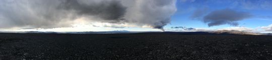
28 January 2015 - the plume
At noon yesterday, the maximum height of the eruptive column was estimated at about 1300 m above the sand plain (notes from IES). Below is a photograph of the gas cloud from an earlier surveillance flight.

28 January 2015 10:00 - from geoscientist on duty
No changes have been observed in the activity past 24 hours. There has been good visibility on webcams to the eruption site yesterday and this morning. The largest earthquake since yesterday occurred this morning at 07:36 in the northern caldera rim of magnitude 3.5. About 10 quakes were observed in the dike intrusion during the past 24 hours. In Bárðarbunga there were over thirty quakes observed, the largest up to magnitude 3.5.
27 January 2015 12:00 - from the Scientific Advisory Board
The volcanic eruption in Holuhraun continues. Visible intensity of the eruption was low last Wednesday when various observations were done at the eruptive site. Comprehensive cross-section measurements from air (30 Dec and 21 Jan) show, however, that the lava field has thickened substantially during these three weeks and that the volume of the lava field is now little less than 1.4 km³. The flow of magma, during this period, was just under 100 m³ per second. The intensity of the eruption is there for slowly decreasing. Hopefully it will be possible to measure the volume of the lava field again later this week, which will give new numbers on the flow of magma.
Notes from the meeting of the Scientific Advisory Board (pdf 0.5 Mb)
27 January 2015 10:00 - from geoscientist on duty
Earthquakes the last 24 hours are similar to the last days. Good visibility was through webcams to the eruption yesterday evening and this morning. The largest earthquake, M4.3, occurred yesterday evening at 19:24. Bárðarbunga caldera: Almost 30 earthquakes have occurred the last 24 hours, one between M4 and M5. The intrusive dyke: About 10 earthquakes up to M 1.3 were detected in the last 24 hours.
26 January 2015 - a flight report
Notes (IES) from a surveillance flight 21st January 2015 include many photographs and explanations, made by the Institute of Earth Sciences. The flight is operated by the Icelandic Coast Guard (LHG).
26 January 2015 09:45 - from geoscientist on duty
Good visibility to the eruptive site this morning. No significant changes since yesterday morning; the largest earthquake, M4.6, occurred last evening. Bárðarbunga caldera: About 30 earthquakes have been detected, the largest were M4.6 and M4.3 and four more were over M3. The intrusive dyke: About ten earthquakes up to M1.5 were detected.
25 January 2015 12:00 - from geoscientist on duty
Since the last report yesterday morning seismic activity around Bárðarbunga and volcanic activity at the eruption site in Holuhraun remained similar to recent days. Seismic activity is still strong and persistent, but at lower levels compared to previous weeks and months. Bárðarbunga: The strongest earthquake at Bárðarbunga was M4.3 today at 10:17 on the northern caldera rim. Three additional events were M4 or larger, 11 were between M3 and M4. A total of about 50 earthquakes have been detected in the caldera region. Dyke intrusion: Only about 10 earthquakes were detected in the dyke intrusion, none of them larger than M1.5. Other regions: About 10 earthquakes up to M2.5 occurred at Tungnafellsjökull. Almost no activity was detected around Askja and Herðubreið.
24 January 2015 12:00 - from geoscientist on duty
Seismic and volcanic activity around Bárðarbunga and at the eruption site in Holuhraun continue at similar levels compared to recent days, no unusual observations have been made during the last 24 hours. Bárðarbunga: The strongest earthquake at Bárðarbunga was M4.9 this morning at 07:25 in the northern caldera rim. Only one additional event exceeded M4 and 16 were between M3 and M4. A total of about 60 earthquakes have been detected in the caldera region since the last report yesterday morning. Dyke intrusion: About 15 earthquakes were detected in the dyke intrusion, none of them larger than M1.3. Other regions: Last night two small earthquake clusters were measured at Tungnafellsjökull (about 15 events, all M<2.5) and southeast of Herðubreið (about 10 events, all M<2). Similar activity has been frequently observed in previous months.
23 January 2015 - from the Scientific Advisory Board
Notes from the meeting of the Scientific Advisory Board (pdf 0.5 Mb)
23 January 2015 10:00 - from geoscientist on duty
No significant changes in seismic and volcanic activity have been observed since the last report yesterday morning. Bárðarbunga: The strongest earthquake was M4.7 last night at 03:07 on the northern caldera rim. It was the only event larger than M4 during the last 24 hours. Additionally, 19 events exceeded M3 and all in all about 60 earthquakes have been detected. Dyke intrusion: About 25 earthquakes were observed in the dyke intrusion, the strongest was M2.1 last night at 00:31 close to the eruption site in Holuhraun. Albeit the vast majority of events in the dyke is located between the northern part of Dyngjujökull and the eruption site, some small events were detected in the southwestern part of the dyke, closer to Bárðarbunga.
22 January 2015 - new equipment at Holuhraun
New equipment was installed near the eruptive site, a weather station and a MultiGAS detector.

22 January 2015 09:45 - from geoscientist on duty
General assessment: Although no significant changes in seismic and volcanic activity are observed from one day to the other, the overall activity has continued to decrease slowly in recent weeks. The last earthquake larger than magnitude 5 occurred two weeks ago. The daily number of earthquakes larger than magnitude 3, as well as the total number of detected earthquakes around the Bárðarbunga caldera, is now lower than it has been in previous months. However, seismic activity in the dyke intrusion continues at rather stable levels with 15-25 detected earthquakes per day, all smaller than magnitude 2.
This day's report: The strongest earthquakes at the Bárðarbunga caldera since the last report yesterday morning were around magnitude 4.5; all together four events exceeded magnitude 4 and eleven were between magnitude 3 and 4. A total of around 40 earthquakes has been detected. About 20 earthquakes were detected in the dyke intrusion, none of them stronger than magnitude 1.2.

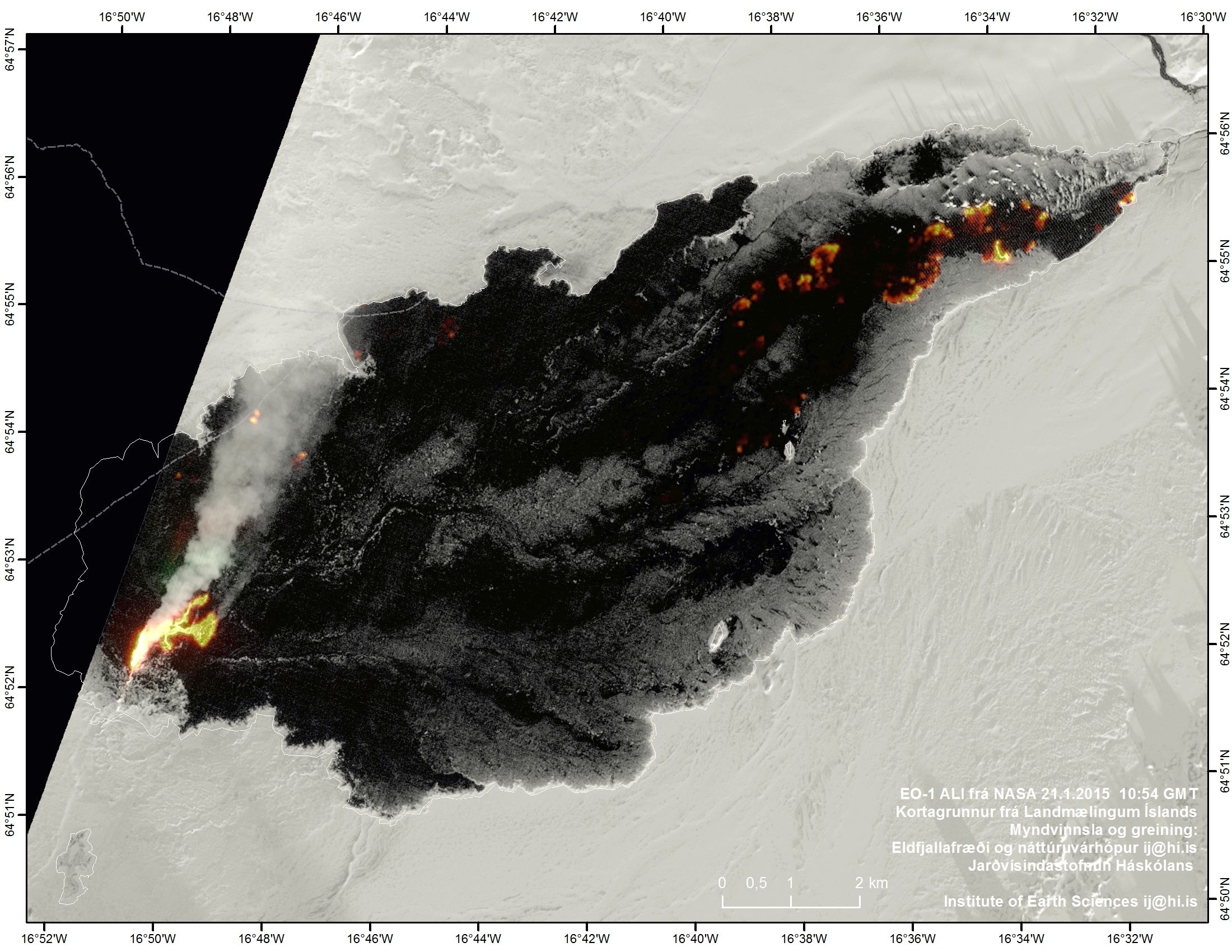
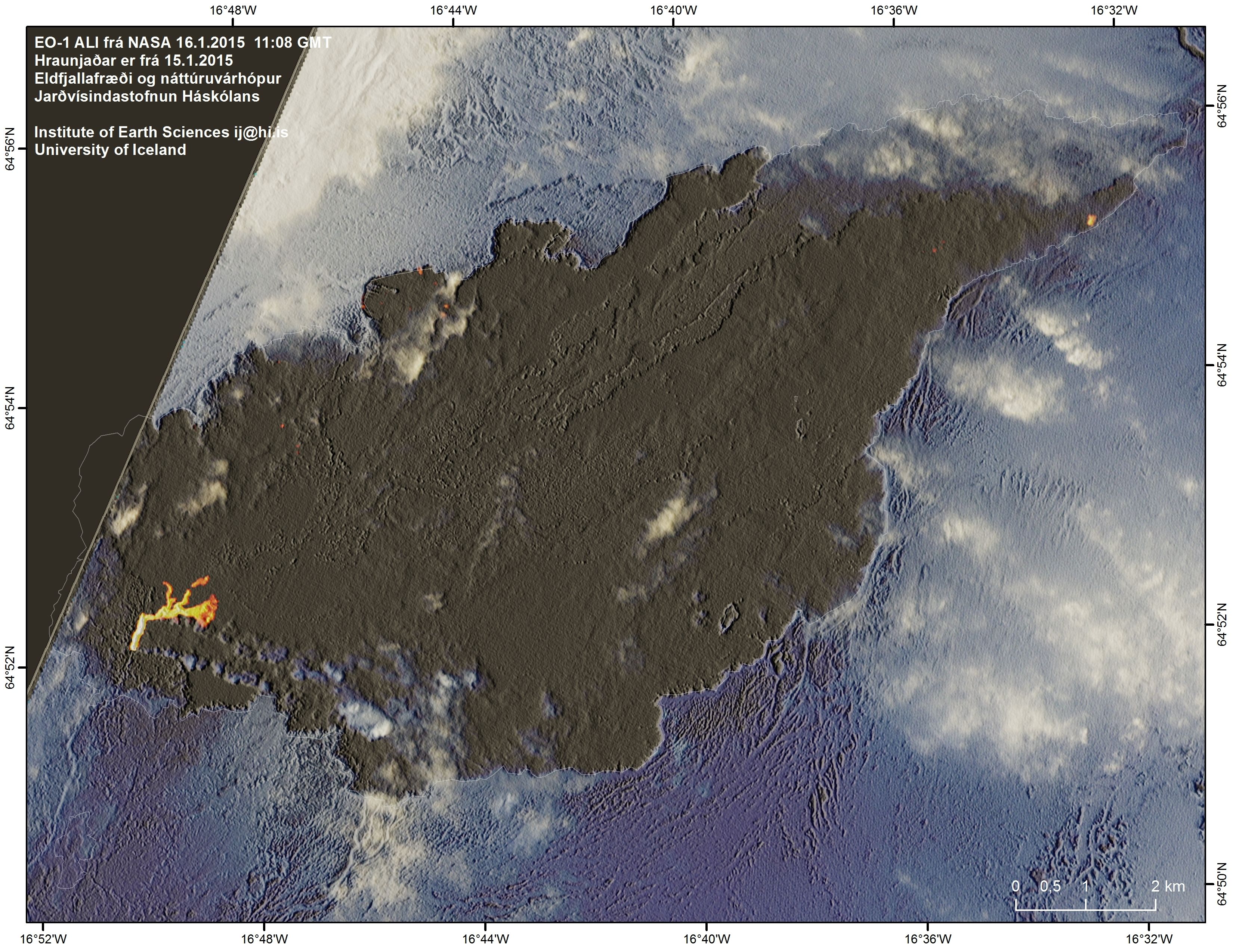
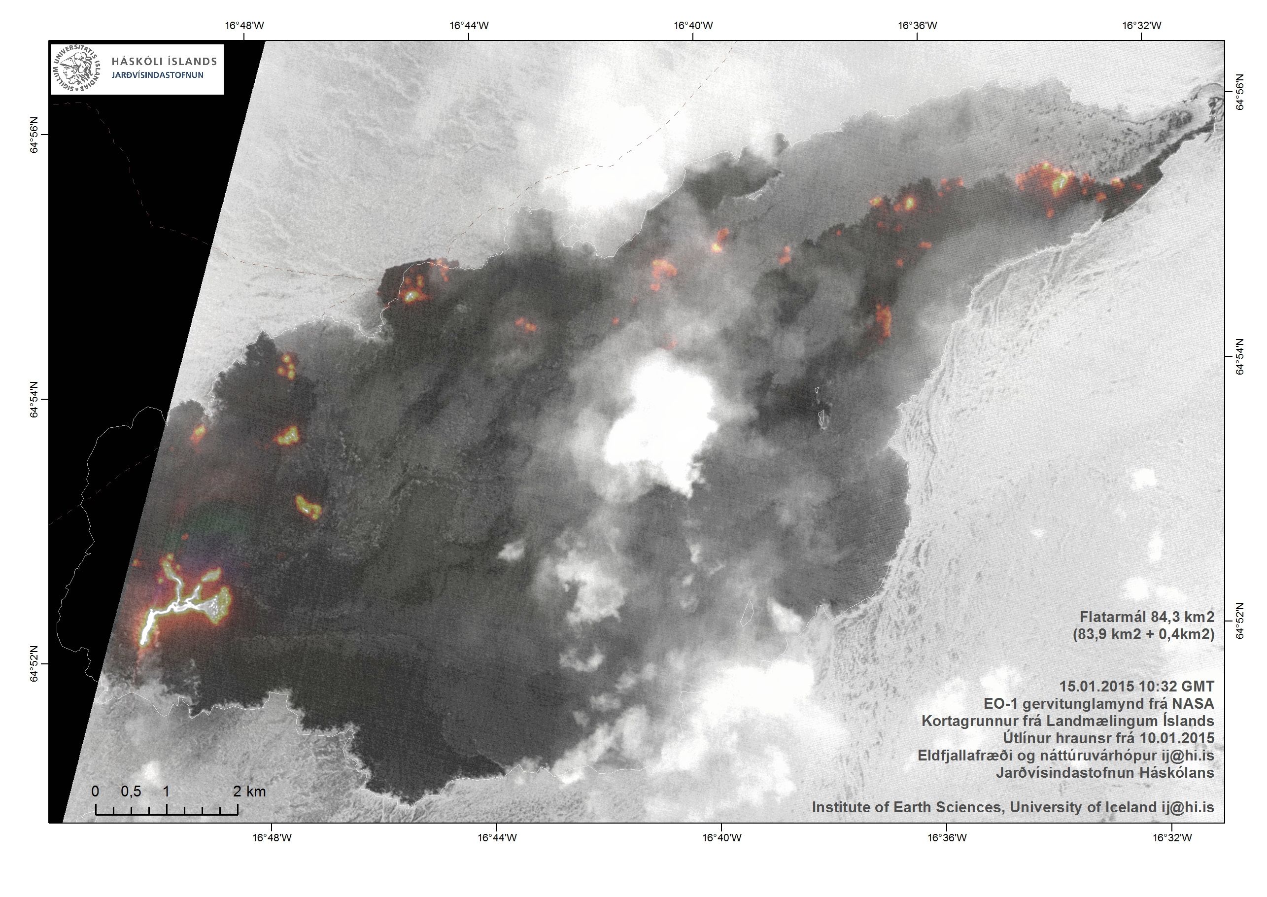
Additionally, the Institute of Earth Sciences has processed an EO-1 satellite image from NASA in order to show the topography of the lava field and enhance the active patches. The area is now 84.3 km² + 0.4 km² or 84.7 km². The only visible addition since 18.1 is at the NE edge though activity is seen elsewhere.
Handheld meters, carried by scientist near the eruptive site 21 Jan, showed SO2 concentrations of 29 ppm and 14 ppm. This is in concordance with the sulphur veils apparent from the aircraft and is reminiscent of the circumstances in SE Iceland 28 October 2014. Since 1 ppm is about 3000 µg/m³ this refers to concentrations of 87,000 µg/m³ and 42,000 µg/m³ respectively. For comparison, see values in the table compiled by the Environment Agency of Iceland and the Directorate of Health.
21 January 2015 09:30 - from geoscientist on duty
Since the last report yesterday morning, activity has continued at stable levels. No significant changes were observed in seismicity around Bárðarbunga or in the dyke intrusion, or in volcanic activity at the eruption site in Holuhraun. The strongest earthquake at the Bárðarbunga caldera was magnitude 4.7 yesterday morning at 10:32 on the southern caldera rim. Four additional events exceeded magnitude 4 and eight were in the range between magnitude 3 and 4. In total, approximately 40 earthquakes were detected around the caldera. Around 20 earthquakes were detected in the dyke intrusion, all of them smaller than magnitude 1.5. Low activity around Tungnafellsjökull, Askja and Herðubreið.

20 January 2015 - from the Scientific Advisory Board
Notes from the meeting of the Scientific Advisory Board (pdf 0.5 Mb)
20 January 2015 10:00 - from geoscientist on duty
Seismic activity around Bárðarbunga and in the dyke intrusion continues at similar levels as in recent days. No changes were observed in the eruption in Holuhraun. Around 50 earthquakes were detected around the Bárðarbunga caldera rim, the strongest was magnitude 4.3 at 22:12 yesterday.
19 January 2015 10:00 - from geoscientist on duty
During the last 24 hours seismic activity around the Bárðarbunga caldera and in the dyke intrusion continued at comparable levels as in recent days. However, noise due to present storm conditions influences the seismic measurements and small earthquakes might not be detected. The eruption in Holuhraun continues, no obvious changes are observed. Around 40 earthquakes have been detected around the caldera rim, the strongest was magnitude 4.4 yesterday evening at 22:27. Five additional events were larger than magnitude 3. About 15 events occurred in the dyke intrusion, around the eruption site and under Dyngjujökull. All of them were smaller than magnitude 1.5.

18 January 2015 11:30 - from geoscientist on duty
Since noon yesterday approximately 60 earthquakes have occurred at Bárðarbunga; the largest being an M4.7 at 07:35 this morning, originating at the northern rim of the caldera. Three more earthquakes in the range 4 – 4.7 were detected. About 15 earthquakes were detected in the dyke intrusion, all under 2 in magnitude.
17 January 2015 11:30 - from geoscientist on duty
Since yesterday morning about 40 earthquakes have been detected in Bárðarbunga. The largest was M4.5 at 17:38, located at the northern rim of the caldera. In total, five earthquakes in the range 4 – 4.5 occurred at Bárðarbunga. In the dyke intrusion there were 15, all less than 2 in magnitude. Little activity was at Tungnafellsjökull and Herðubreið.
This morning (17 Jan) a series of earthquakes is occurring at the Torfajökull area, 2-3 km west of Landmannalaugar. The largest was an M2.5 at 10:28 but a dozen in total. These earthquakes are of shallow origin and are probably caused by geothermal activity in the area.

16 January 2015 - from the Scientific Advisory Board
Notes from the meeting of the Scientific Advisory Board (pdf 0.4 Mb).
16 January 2015 09:30 - from geoscientist on duty
Today, there are five months since the onset of seismic events in Bárðarbunga. The volcanic activity began two weeks later.
Since yesterday morning, just over 40 earthquakes have been detected at Bárðarbunga; the largest was an M4.3 which occurred at 12:52 yesterday (15 Jan) at the northern rim of the caldera. In total, six earthquakes at the interval 4 - 4.3 occurred at Bárðarbunga. Around ten earthquakes were detected in the dyke intrusion, all under 2 in magnitude. At Tungnafellsjökull and Herðubreið, seismic activity was negligible.

15 January 2015 10:00 - from geoscientist on duty
About 50 earthquakes have been observed in Bárðarbunga past 24 hours. The largest quake was of magnitude 4.6 at 07:11 this morning in the southern caldera rim. In total, nine quakes were between magnitudes 4.0 and 4.6. About ten quakes were observed in the dike intrusion, all below magnitude 2. Also about ten quakes were observed in Herðubreið and Herðubreiðartögl, the largest of magnitude 2.3 at about 10:00 yesterday.

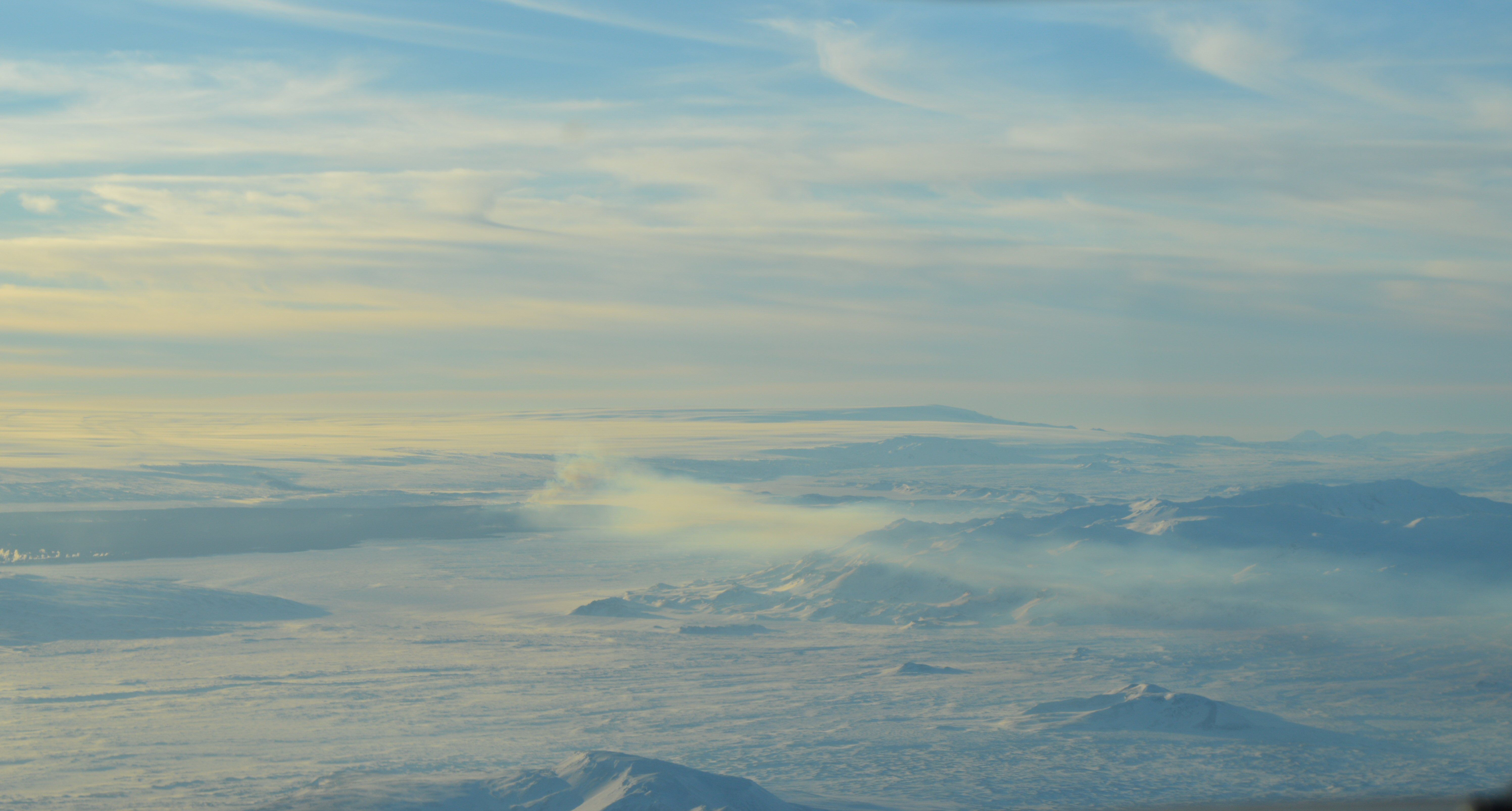
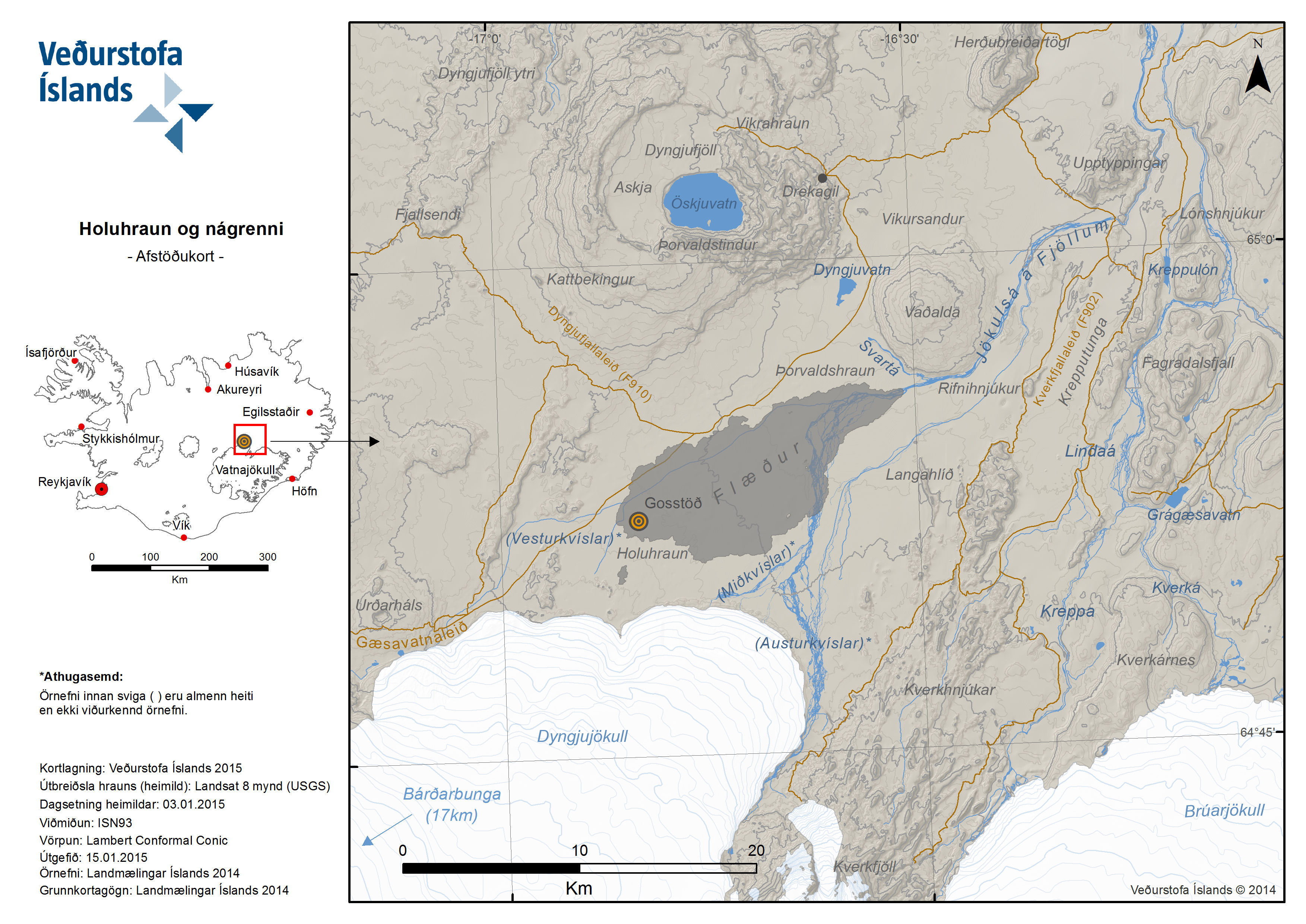
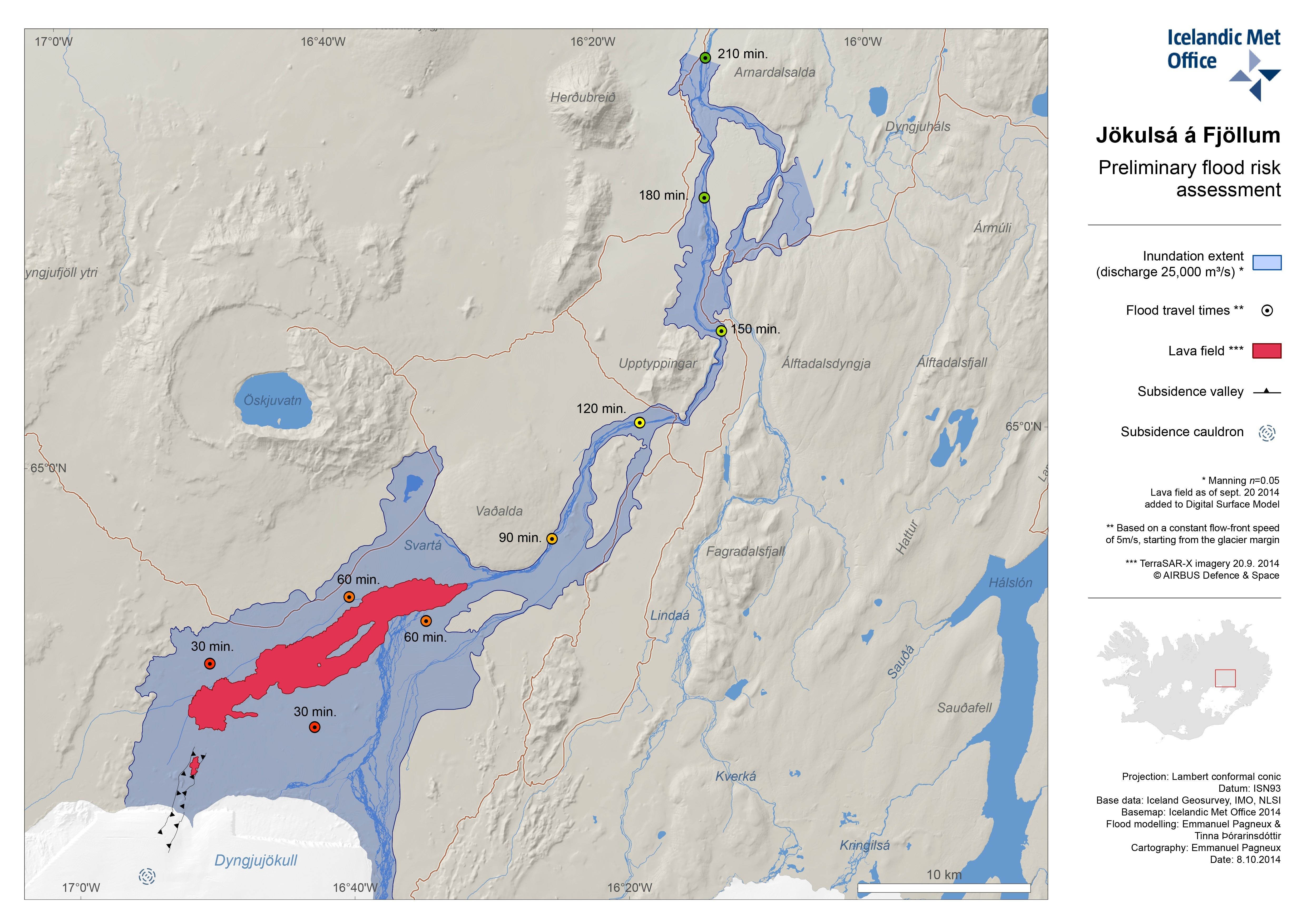
Location map of the eruption site north of Bárðarbunga (enlarge).
14 January 2015 10:00 - from geoscientist on duty
Almost 50 earthquakes were observed since yesterday morning in Bárðarbunga. The largest quake was of magnitude 4.6 at 17:51 in the northern caldera rim. Another quake of magnitude 4.6 occurred in the southern caldera rim at 15:00 yesterday. In total, seven quakes were registered of magnitude 4.0 to 4.6. Almost 15 quakes were observed in the dike intrusion, all below magnitude 2. Also about 15 quakes were observed in Tungnafellsjökull, the largest of magnitude 3.1 at 13:17 yesterday.
13 January 2015 - from the Scientific Advisory Board
Notes from the meeting of the Scientific Advisory Board (pdf 0.4 Mb)
13 January 2015 10:00 - from geoscientist on duty
About 50 earthquakes have been observed since yesterday morning in Bárðarbunga. The largest quake was of magnitude 4.5 at 18:30 yesterday in the northern caldera rim. Five quakes were between magnitude 4 and 4.5. Almost 10 quakes were observed in the dike intrusion, all below magnitude 2. A few quakes were observed in the northern part of Tungnafellsjökull last night, the largest of magnitude 2.2.
12 January 2015 12:00 - from geoscientist on duty
The fires at Holuhraun were well visible on webcams this morning. The largest earthquake in Bárðarbunga since noon yesterday was M4.4 at 00:22, originating at the southern margin of the caldera. Five other quakes were over 4 in magnitude and altogether around 25 quakes were detected in Bárðarbunga. A few were detected in the dyke intrusion, all under 2 in magnitude.
11 January 2015 12:00 - from geoscientist on duty
Since noon yesterday, about 30 earthquakes have been detected at Bárðarbunga; the largest was an M4.7 at the northeastern rim of the caldera at 18:23 (10 Jan). A few others were just over M4. Ten or so quakes, 1 in magnitude or less, occurred at the dyke intrusion.

10 January 2015 - aerial photos
Another article stores photos from a surveillance flight 10 January 2015 (Morten S. Riishuus, IES).
10 January 2015 - an equipment rescued from the lava
In a field excursion, a FutureVolc DOAS instrument was rescued from the advancing lava front.
10 January 2015 11:40 - from geoscientist on duty
Around 50 earthquakes have been detected at Bárðarbunga during the last 24 hours. The largest, M.4, occurred this morning at 07:10 (10 Jan) and is the only one above 4 since yesterday morning. Just under a dozen quakes was detected in the dyke intrusion, all near or under 1 in magnitude. Fair visibility towards the eruptive site, similar intensity as recently.
9 January 2015 - from the Scientific Advisory Board
Notes from the meeting of the Scientific Advisory Board (pdf 0.4 Mb)
9 January 2015 10:00 - from geoscientist on duty
Over 30 earthquakes were observed in Bárðarbunga during the past 24 hours. About five quakes were between magnitude 4 and 5. The largest quake occurred at 18:47 yesterday (8 Januray) of magnitude 5.1 in the norheastern caldera rim. Over ten quakes were observed in the dike intrusion, most below magnitude 1. Good visibility is to the eruption site on web cameras and the eruption seems to be similar in strength as during previous days.
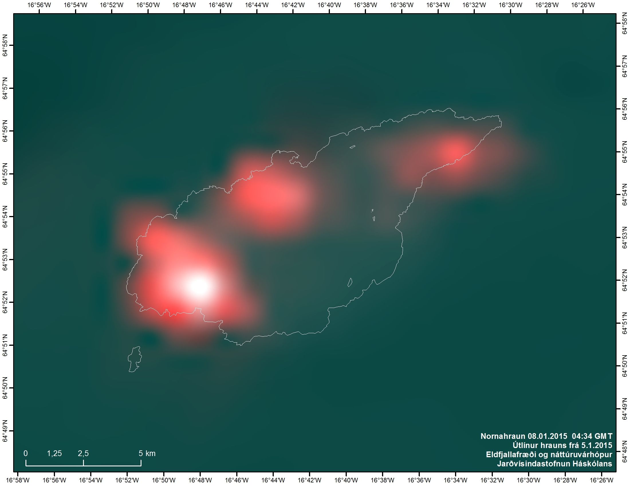
8 January 2015 10:00 - from geoscientist on duty
Over 30 earthquakes have been observed in Bárðarbunga past 24 hours. Four quakes were over magnitude 4, two of magnitude 4.2, at 02:32 and 04:51. The other two were of magnitude 4.0 and 4.1. A few quakes were observed in the dike intrusion, all about or below magnitude 1. The eruption has been clearly seen on web cameras this morning and seems to be similar to previous days.

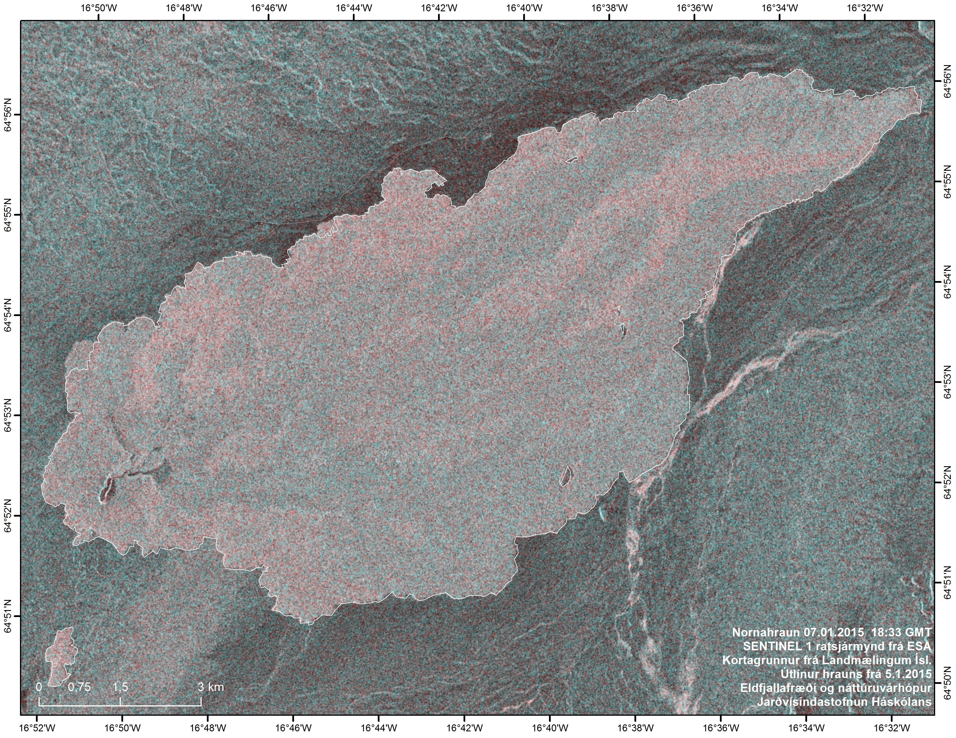
7 January 2015 10:00 - from geoscientist on duty
About 40 earthquakes have been observed in Bárðarbunga during the past 24 hours. A few were between magnitude 4 and 5. The largest occurred in the northeastern caldera rim at 13:36 yesterday of magnitude 4.4. A few quakes have been observed in the dike intrusion, all below magnitude 2. The eruption was visible on web cameras last night and seems to be of similar strength as during past days.
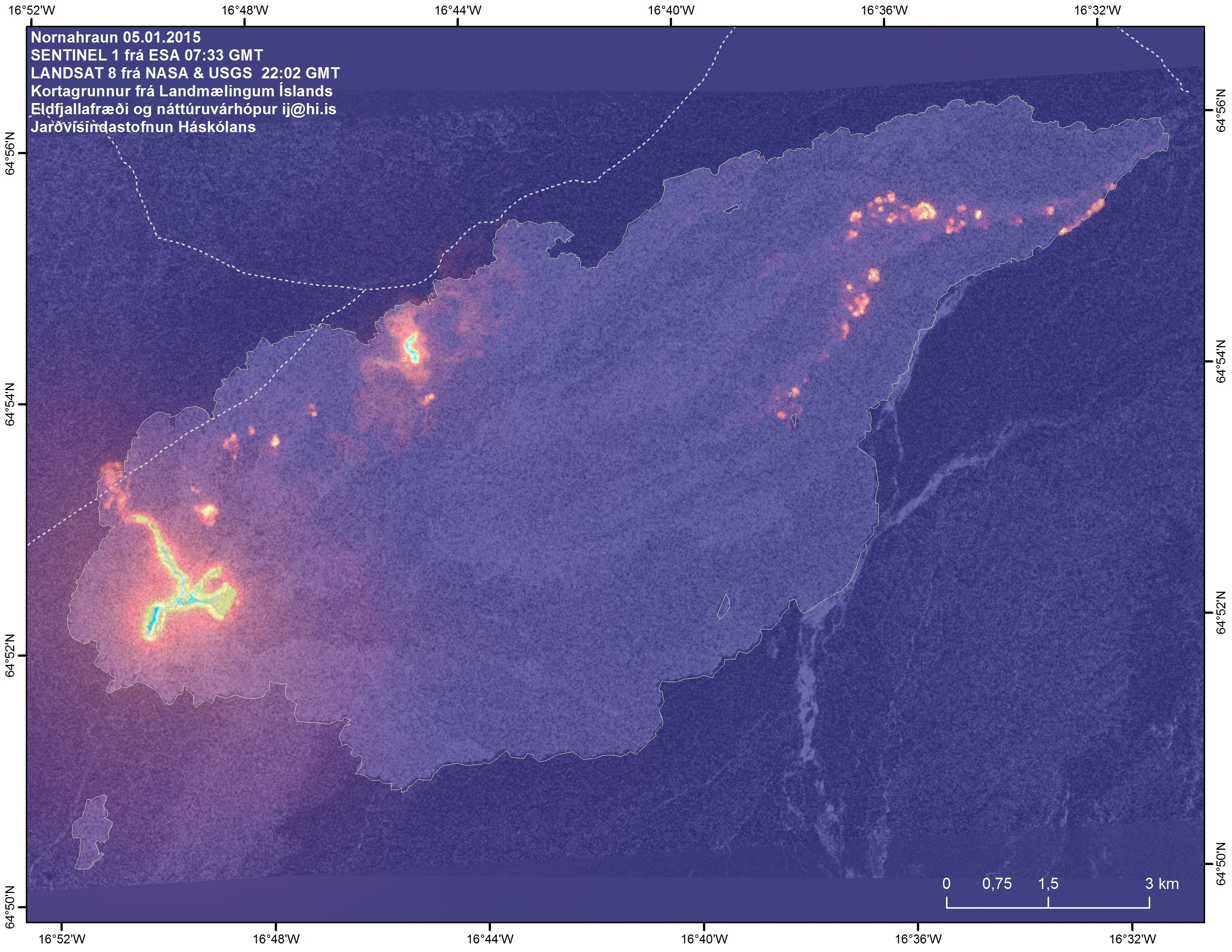
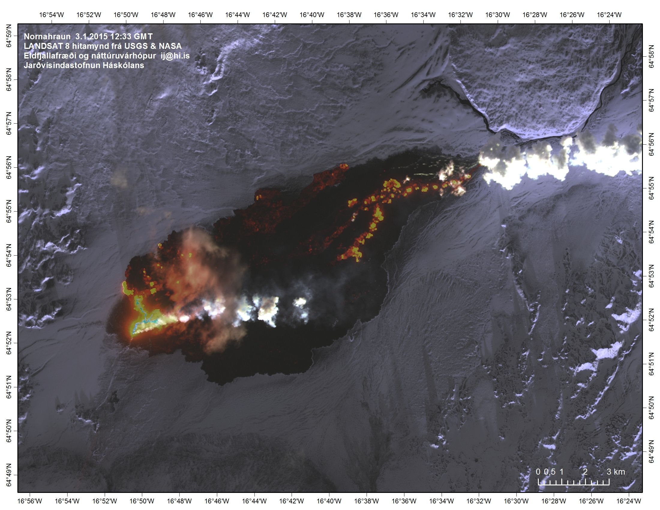
6 January 2015 - one day's growth
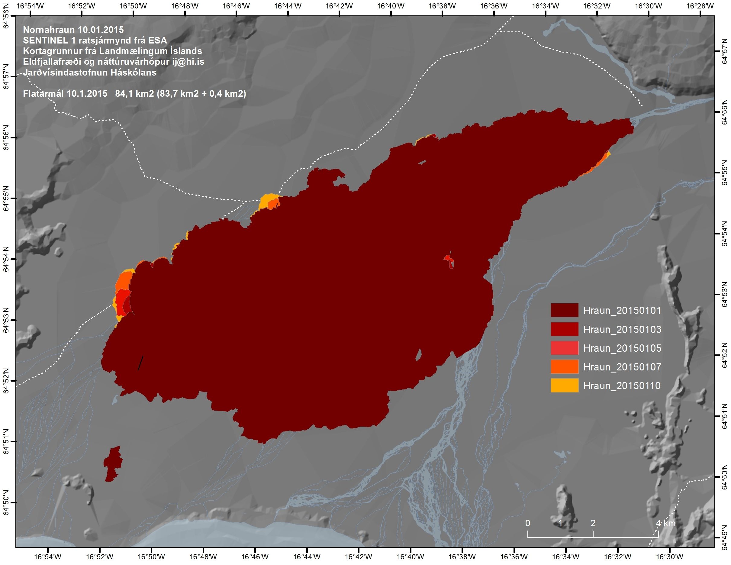
Combined overview map 5 January 2015; the radar image and the outlines of the lava were made early (8am) but the thermal image that evening (10pm). Therefore, the addition that day can be seen clearly on the combined image. The lava covered an area of 83.4 km² (83.0 km² + 0.4 km²) in the morning. The extension occurred mainly at the western margin and has not yet been calculated. There is still some activity at the northeastern margin.
6 January 2015 - from the Scientific Advisory Board
Notes from the meeting of the Scientific Advisory Board (pdf 0.4 Mb)
6 January 2015 10:00 - from geoscientist on duty
Around 30 earthquakes have been detected at Bárðarbunga during the last 24 hours. Three were between 4 and 5 in magnitude. The largest occurred at the northeastern rim at 21:53 last night, M4.9. A few quakes have been detected at the intrusive dyke and at Tungnafellsjökull, all less than M2. Visibility towards the eruptive site has been fairly good and the intensity of it seems to be unchanged.
6 January 2015 - thickness and volume
Radar measurements for height, made by IES during a TF-FMS surveillance flight 30 December 2014, give indications of the thickness and hence the volume of the lava. Preliminary results are presented below, although uncertainties are considerable and full processing of the data will take quite some time:
- Significant thickening of the lava has taken place since the beginning of December, mainly in the eastern part where new lava spread over older tongues of lava.
- The maximum extent since September has been beaten by a small tongue which is progressing slowly along its northern part, the excess is at least 200 m.
- The lava is on average 10 m thick in the eastern part, about 12 m in the center, and about 14 m or more in the western part.
- Maximum thickness of the lava, near the craters, was about 40 m at the eastern margin of the magma lake. Preliminary estimate for the volume of the lava is now 1.1 km³.
Two flight sections were also measured across Bárðarbunga. The subsidence continues in a similar fashion, i.e. about 25 cm/day during the past month. All in all, from mid August, the Bárðarbunga surface has lowered by 59 m (according to this flight, 30 Dec. 2014). Institute of Earth Sciences.

5 January 2015 10:00 - from geoscientist on duty
More than 20 earthquakes have been detected in Bárðarbunga the last 24 hours. The largest one, M4.3 occurred 23:29 yesterday evening. Some smaller earthquakes have been detected in the dyke intrusion and at Tungnafellsjökull.

4 January 2015 12:00 - from geoscientist on duty
The activity in the Bárðarbunga area is comparable to recent days. About 45 earthquakes have been automatically located past 24 hours. Two larger quakes were observed in this period, at 12:01 yesterday and 07:49 this morning, both of magnitude 4.5. Very little activity was observed in Bárðarbunga after the large quake this morning. The surrounding areas have been experiencing continued activity of small quakes, in Tungnafellsjökull, Herðubreiðartögl, and in the dyke intrusion under Dyngjujökull.
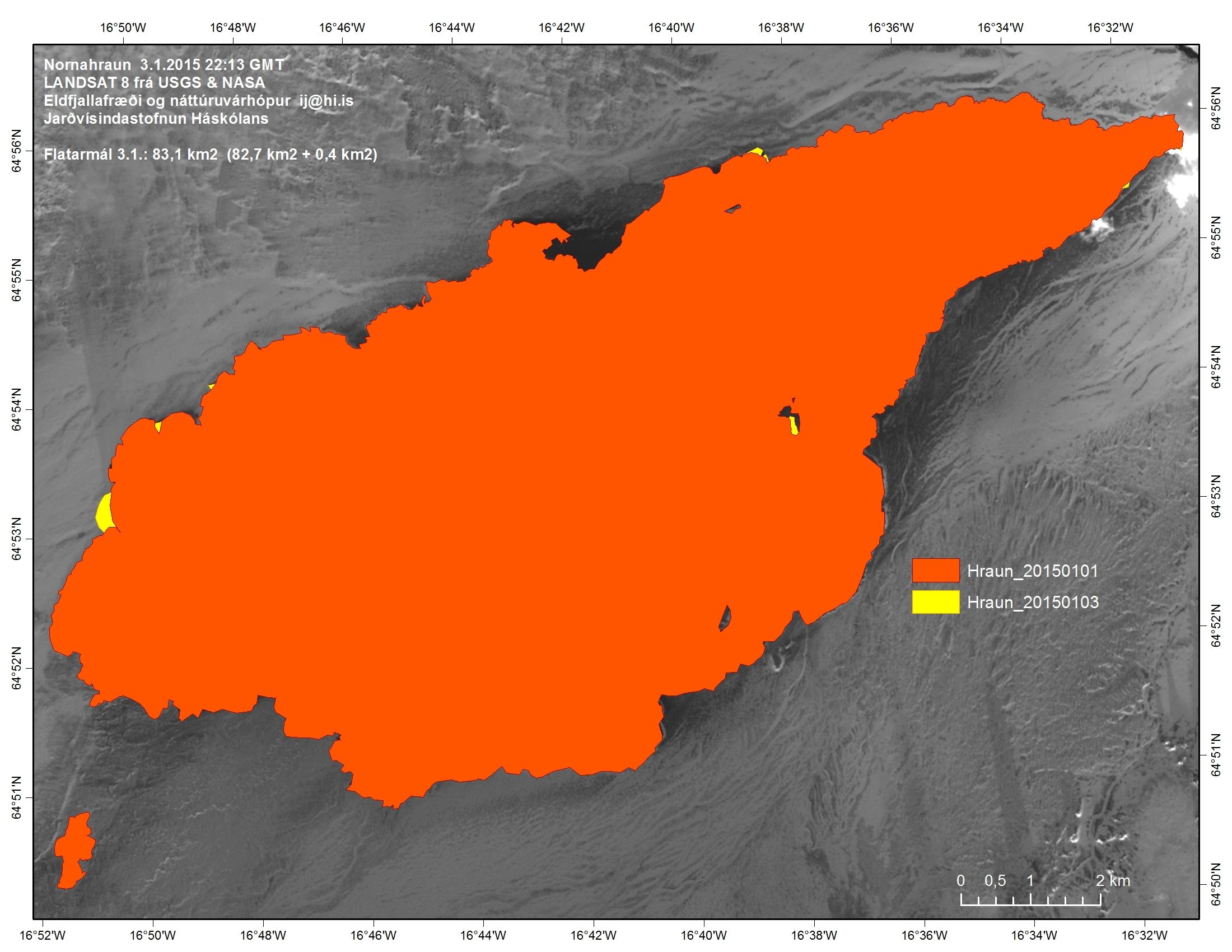
3 January 2015 12:00 - from geoscientist on duty
The activity in Bárðarbunga continues at a similar pace as before. About 50 earthquakes were automatically located during the past 24 hours. The largest quake occurred last night at 00:32, of magnitude 4.6. The activity in surrounding areas continues in Tungnafellsjökull, Herðubreiðartögl and the northern part of the dyke intrusion.
2 January 2015 10:00 - from geoscientist on duty
The activity in Bárðarbunga is comparable to previous days. Over 40 earthquakes have been observed and automatically located since noon yesterday. The largest quake of magnitude 4.6 occurred yesterday at 14:43. Some activity is also observed in surrounding areas; Tungnafellsjökull, Herðurbreiðartögl, and in the northern part of the dyke intrusion.
1 January 2015 12:00 - from geoscientist on duty
Seismic activity in and around Bárðarbunga is similar to what it has been. About 40 earthquakes have been detected during the last 24 hours. The largest earthquake, 4.4, occurred at 14:40 yesterday (31 Dec.). Small earthquakes continue in the area, both in Tungnafellsjökull and at Herðubreiðartögl, as well as in the northern end of the dyke intrusion.
1 - 31 December 2014
Observations from the month of December are found in another comparable article; including a comparison with historic eruptions and an account of the first 100 days of eruption.


