
Bárðarbunga 2015 - February events
Seismic and volcanic events 1 - 28 February
The February observations (pdf 1.28 Mb) of the Bárðarbunga seismic and volcanic events are given here with daily notes, factsheets and additional material. Information, day by day, is given in reversed order. In combination, the monthly articles give an overview of events: August, September, October, November December, January, February, March-April-May and the overview article (list of links).
Calendar
Below is a calendar with a short-cut to each day of the month.
Feb: 1-2-3-4-5-6-7-8-9-10-11-12-13-14-15-16-17-18-19-20-21-22-23-24-25-26-27-28
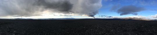 Panoramic view towards the eruptive site in Holuhraun 3rd September 2014. Photo: Richard Yeo.
Updated information
28 February 2015 - gas emissions continue
In spite of relief at the end of the eruption in Holuhraun, conveying gratitude to staff and co-workers, the Icelandic Meteorlogical Office still monitors gas dispersal closely.
Other lava eruptions have taught that the lava field continues to emit gas for a long time yet and without the thermal rise from an open vent, the volcanic gases will tend to follow the ground. Therefore, even higher values of more polluting gas may be expected now than in recent weeks.
28 February 2015 12:00 - declaration from the Scientific Advisory Board
Notes from the meeting of the Scientific Advisory Board (pdf 0.4 Mb). The volcanic eruption is over.
The eruption in Holuhraun, which began 31 August 2014, has come to an END.
- The area continues to be closely monitored.
- Gas contamination is still detected around the eruption site.
- No changes have been made to the restricted area north of Vatnajökull.
- The Civil Protection still operates in alert phase.
- Aviation Colour Code for Bárðarbunga has been downgraded from orange to yellow.
27 February 2015 15:15 - no glow seen in flight
In a helicopter flight today, no glow was seen at the eruptive site. So it seems that magma flow is over, i.e. that new and hot magma flows no longer to the surface through the vents in Holuhraun. Volcanic gas is, however, still being released from the eruptive site and the lava field.
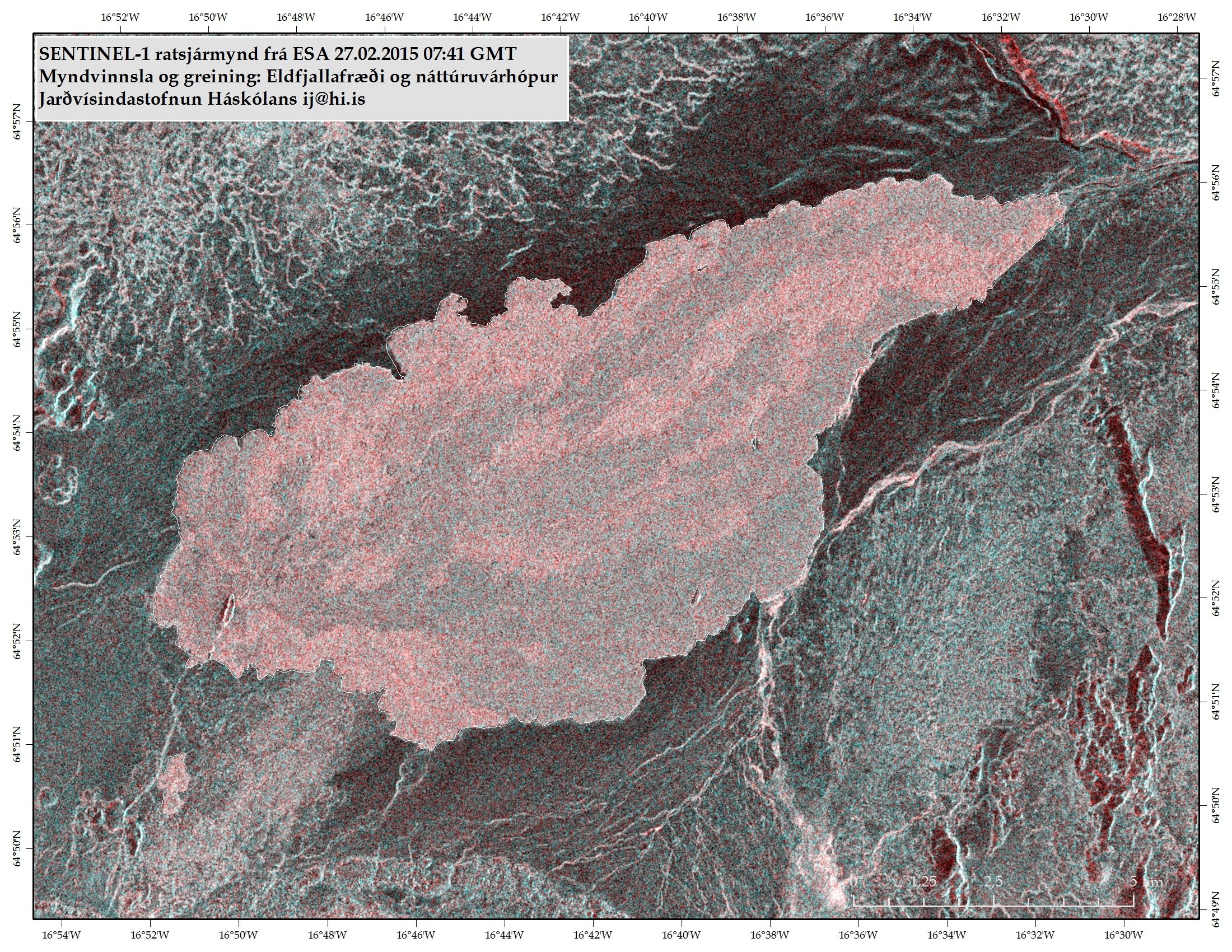
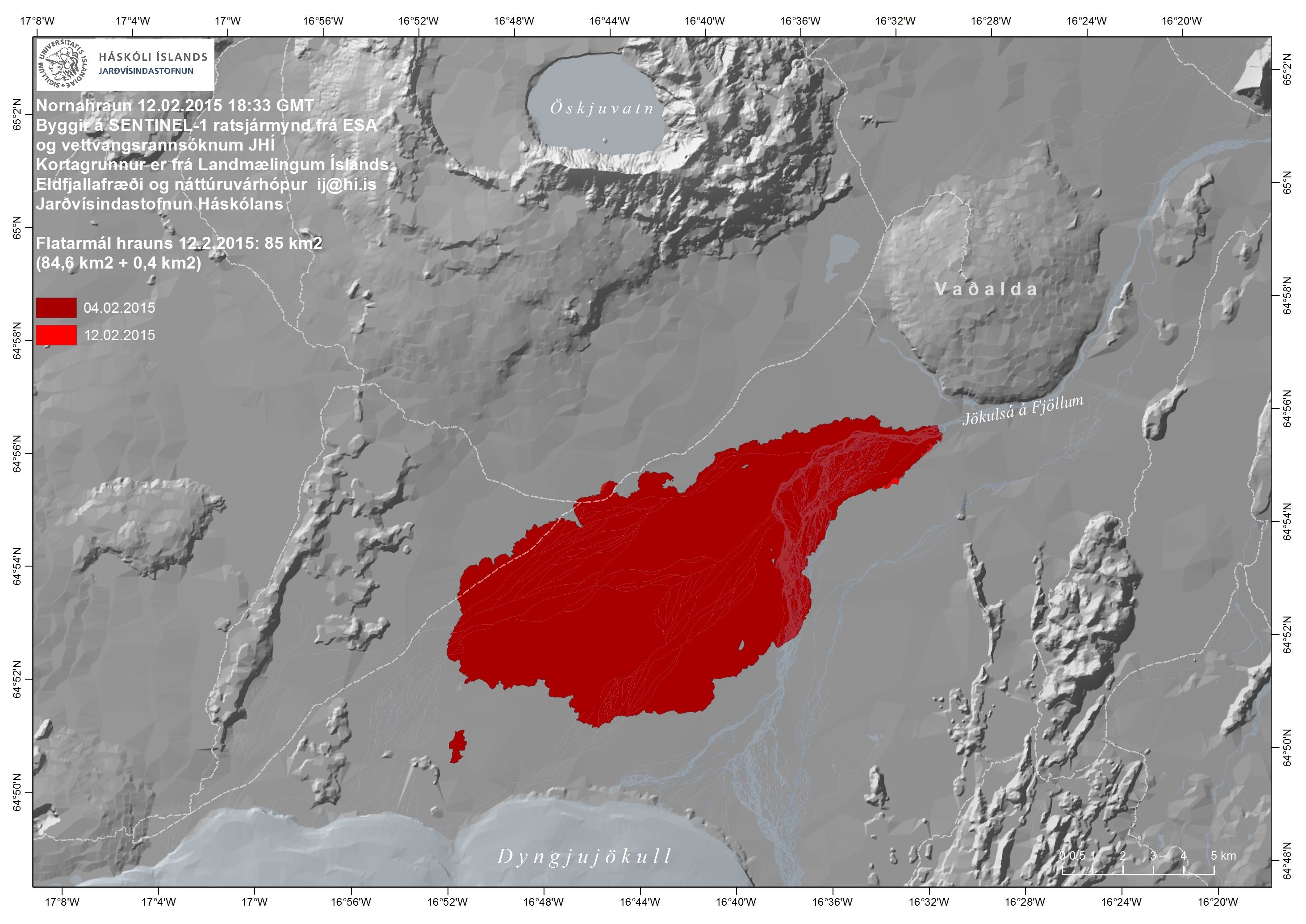
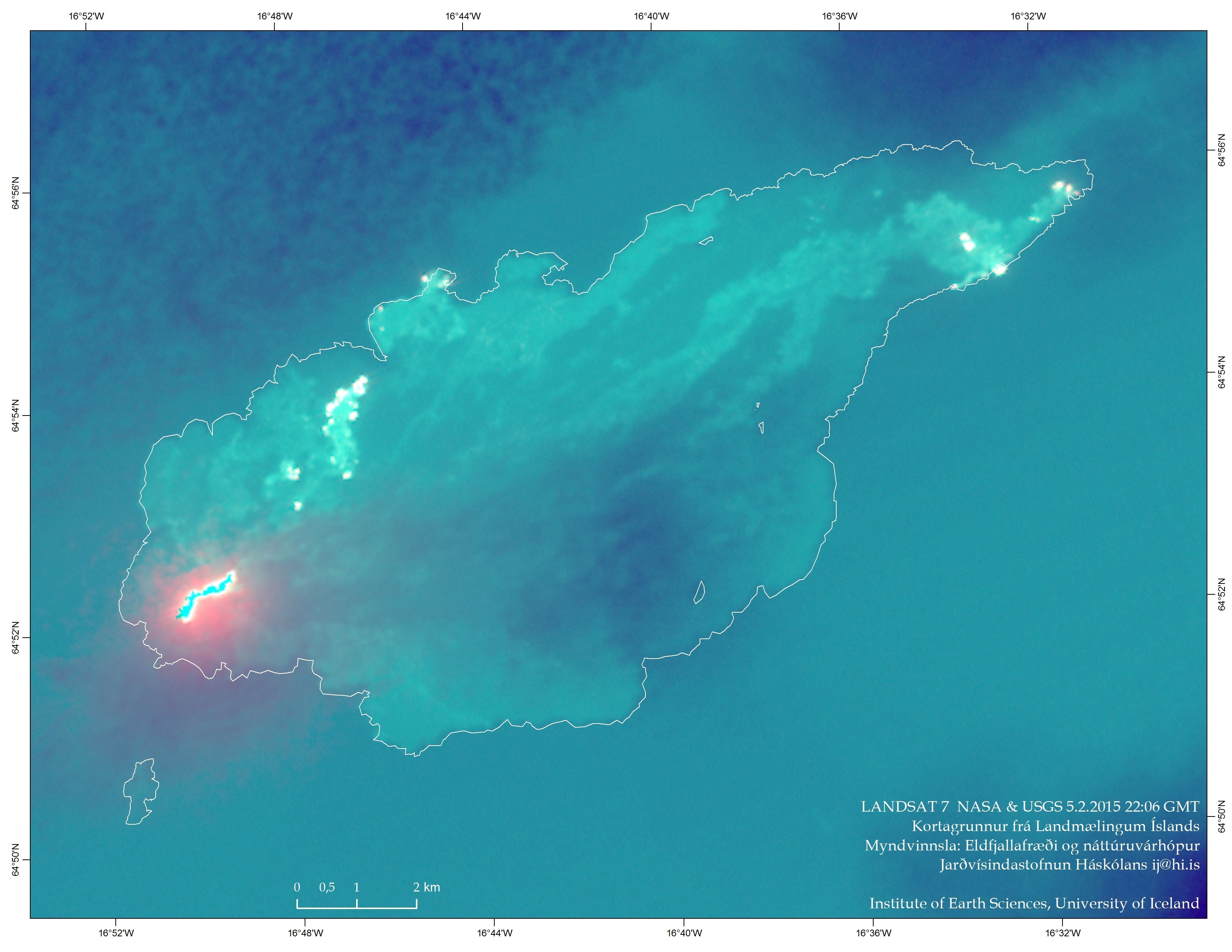
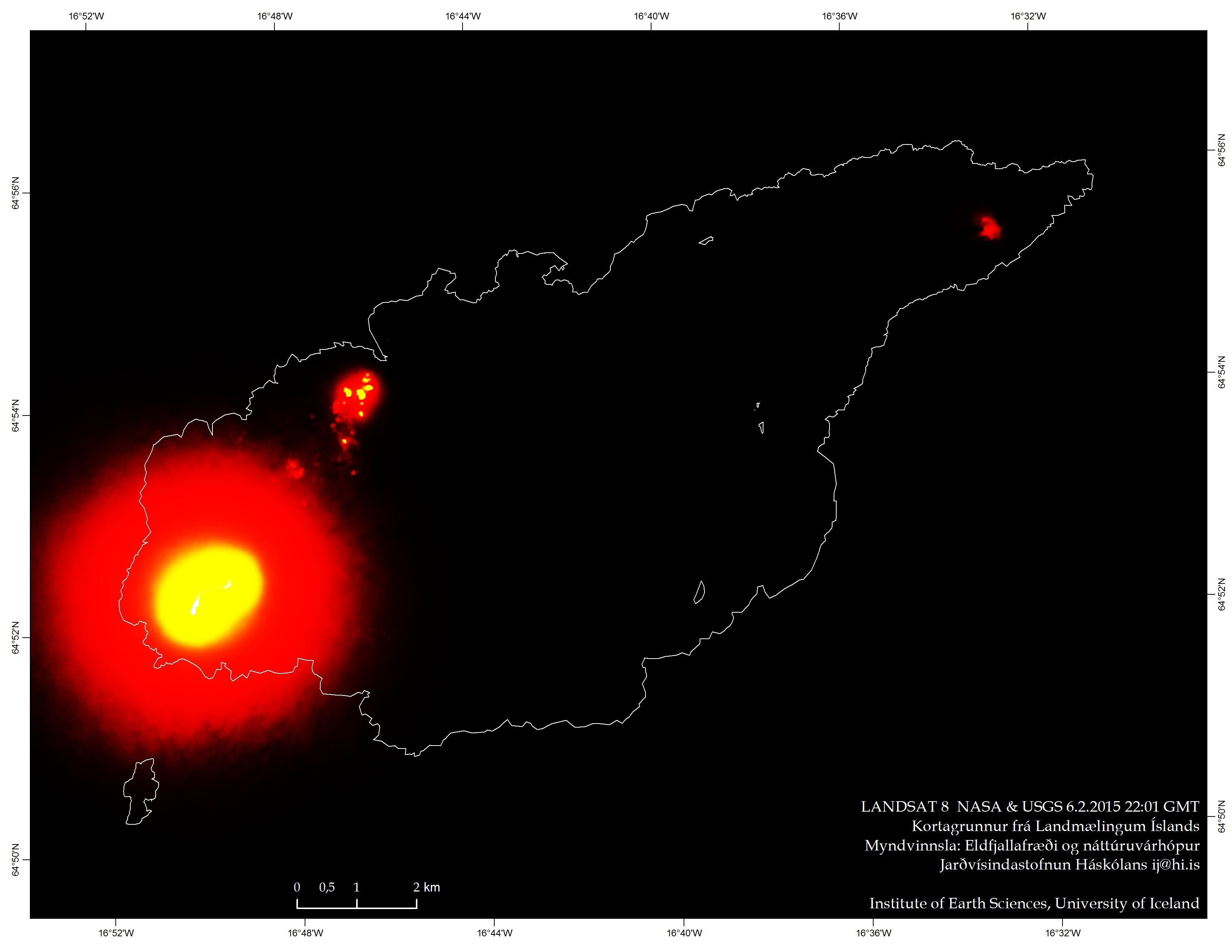
27 February 2015 - radar image of the lava

27 February 2015 12:00 - from the Scientifc Advisory Board
Notes from the meeting of the Scientific Advisory Board (pdf 0.4 Mb).
Seismic activity in Bárðarbunga continues to diminish. No earthquake over M3 has occurred since 21 February and none over M5 since 8 January.
GPS measurements near Vatnajökull ice cap show continuing slow deflation towards Bárðarbunga, still indicating a flow of magma from under the volcano. The subsidence of the caldera was 5 cm per day last week, correcting for the ice which slowly flows into the caldera.
An automatic gas detector at Blönduós (North Iceland) showed 500 μg/m³ SO2 yesterday (26 Feb.).
27 February 2015 10:00 - from geoscientist on duty
Over ten earthquakes were observed in Bárðarbunga past 24 hours. The largest quake was of magnitude 2.5 at 01:59 last night, but other quakes were below magnitude 2. In the dike intrusion about 20 quakes were observed, all below magnitude 1.3. Two quakes were observed in Tungnafellsjökull, the lager of magnitude 1.2. At Herðubreið and Askja five quakes were observed, all below magnitude 1.3.
26 February 2015 - thermal image from the field

26 February 2015 10:00 - from geoscientist on duty
Over ten earthquakes have been observed in Bárðarbunga past 24 hours. All the quakes were below magnitude 1.4. Also over ten quakes observed in the dike intrusion and all below magnitude 1.4. Two quakes observed in Tungnafellsjökull, the larger one of magnitude 1.7. Seven quakes were observed in Askja, the largest of magnitude 2.3 at 05:42 last night. At Herðubreið three quakes were observed all below magnitude 2.
25 February 2015 10:00 - from geoscientist on duty
Since yesterday morning over 20 earthquakes were observed in Bárðarbunga. The largest were of magnitude 1.7. In the dike intrusion 20 quakes were observed, all below magnitude 1.5. A few quakes were observed at Herðubreið and Herðubreiðartögl, all below magnitude 2.
24 February 2015 - low SO2 values in populated areas
No high values of sulfurdioxide, SO2, have been detected on the twenty or so automatic gas measuring stations at populated areas recently. None of those has passed the health limit of 350 µg/m³ since 5 February. Today is the nineteenth day below the limit at all stations. The second longest period with values below 350 µg/m³ on all stations since mid September 2014 (when the current network reached more or less the final size) is five days (5 - 9 January). It is vital to keep in mind that this does not apply to the wilderness closer to Holuhraun.
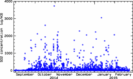 An overview from automatic stations at populated areas, monitoring gas from the eruption in Holuhraun. The graph shows daily maxima of 1 hour average SO2 concentrations in air (μg/m³) at each of the twenty stations. The figure spans 29 August 2014 - 28 February 2015.
24 February 2015 12:00 - from the Scientifc Advisory Board
Notes from the meeting of the Scientific Advisory Board (Pdf, 0.4 Mb).
Lava flow in Holuhraun has decreased substantially. Seismic activity in Bárðarbunga continues to diminish although it can still be considered strong. The largest earthquake since Friday was M3.7 on Saturday, 21st of February, at 15:20.
The rate of subsidence in the Bárðarbunga caldera is now less than 2 cm per day. However, ice flows slowly into the caldera, affecting the GPS measurements, so care is needed with their interpretation.
24 February 2015 10:00 - from geoscientist on duty
Since 10:00 yesterday morning over 10 earthquakes have been detected in Bárðarbunga caldera, all of them smaller than M2. In the dyke intrusion ca 15 earthquakes were detected, the largest one M1.5. Ca 20 earthquakes have occurred at Herðubreið/Herðubreiðartögl, all of them less than M2.
No visibility has been to the eruption site via webcams since last night as it is snowing in the area.

23 February 2015 10:00 - from geoscientist on duty
Since 12:00 yesterday, 22.02., just over 10 earthquakes were detected in Bárðarbunga, the largest ones ca M2. In the dyke intrusion ca 20 earthquakes were detected, all of them smaller than M1.5. Three earthquakes, smaller than M2, were detected at Askja and Herðubreið.
Sligthly before 08:00 this morning a glow from the eruption could be seen in webcams.
22 February 2015 12:00 - from geoscientist on duty
Seismic and volcanic activity continue at similar levels as during previous days. Three earthquakes larger than magnitude 3 occurred around the Bárðarbunga caldera since the last report yesterday morning, the strongest was M3.7 yesterday afternoon at 15:20. All in all about 25 earthquakes were detected. About 20 events occurred in the dyke intrusion, all of them smaller than M1.2. Four events were measured around Askja and three around Herðubreið.
21 February 2015 - aerial photos from the first five months

21 February 2015 - the land, the lava and the lakes

21 February 2015 12:00 - from geoscientist on duty
Bárðarbunga: Activity around the caldera and in the dyke intrusion continues at similar low levels as in recent days. No earthquake exceeded magnitude 3 for more than 48 hours. This is the first time since the beginning of the activity in August last year that the Vatnajökull earthquake map does not show a "green star" (magnitude larger than 3). All together about 10 earthquakes were detected around the caldera and about 15 in the dyke intrusion since the last report yesterday morning.
Katla: A shallow magnitude 3.3 earthquake occurred under the western Katla caldera last night at 02:26. About 5 aftershocks up to magnitude 2.2 have followed. Activity has decreased quickly, so we are still far away from talking about an earthquake swarm. Such short shallow sequences with earthquakes of magnitude 3 and stronger have frequently occurred in recent years and are most likely linked to hydrothermal activity in the caldera. No changes of water levels or electric conductivity have been observed in surrounding rivers.
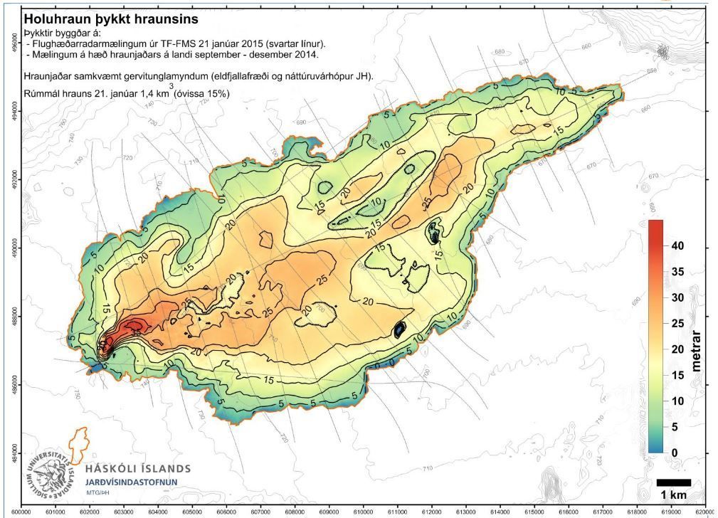
20 February 2015 - a new IES report from the eruption site
Excerpt from a new field report from the Institute of Earth Sciences, 17 - 19 February:
There is only one active vent inside the crater and the surface of the molten lava continues to sink. The lava channel has crusted over, except the 200 - 300 m nearest to the vent. The eruption column reaches no more than 1000 m above ground. The photos below show breakouts 15 – 16 km ENE of the vent, fed by the closed lava pathway which is inflating the lava field.


20 February 2015 12:00 - from the Scientific Advisory Board
Notes from the meeting of the Scientific Advisory Board (pdf 0.4 Mb). The volcanic eruption in Holuhraun continues, but it has diminished substantially over the last few weeks. Visual activity in the crater has decreased and the lava field is hardly increasing in size.
20 February 2015 10:00 - from geoscientist on duty
Earthquake activity around the Bárðarbunga caldera has been rather low following a pulse of stronger activity yesterday morning between 01:25 and 02:10. During the past 24 hours, about 15 earthquakes were detected in the caldera, non of them exceeded M3. About 20 earthquakes occurred in the dike intrusion, the strongest was M1.6 today at 08:24. Additionally, five earthquakes were measured around Askja and about 10 around Herðubreið.
19 February 2015 - on pulses and the time lapse between them
Earthquake pulses on the caldera rim of 30-90 minutes duration, like the one observed last night, have been characteristic for the seismic activity linked to the caldera subsidence since the beginning of the sequence last summer.
Such pulses were observed several times per day during the first months, but time intervals between them have significantly increased from 2 - 4 hours in the beginning to 12 - 24 hours or even more now in February.
The decreasing magnitude of the strongest earthquakes, and the increasing time intervals between them, are in accordance with the generally observed decay of seismic and volcanic activity in the region over the last weeks and months.
However, activity levels are still considerable and IMO is monitoring the situation very closely.
19 February 2015 10:00 - from geoscientist on duty
The strongest earthquakes on the Bárðarbunga caldera rim since the last report yesterday morning were M4.1 yesterday at 14:17 and M4.3 at 01:26 last night. A total of around 30 events has been detected around the caldera in the last 24 hours, most of them in a pulse of events between 01:25 and 02:10 this morning. About 15 earthquakes were observed in the dyke intrusion, all smaller than M1.5. A few events were detected around Askja and Herðubreið.
18 February 2015 - from geoscientist on duty
No significant changes were observed in the seismic and volcanic activity around Bárðarbunga in the last 24 hours. Activity remains at low but persistent levels. Around 25 earthquakes were detected on the Bárðarbunga caldera rim, none of them exceeded magnitude 3. About 15 earthquakes were observed in the dyke intrusion, all smaller than magnitude 1.5. Three small earthquakes occurred close to Askja.
17 February 2015 - slow and steady decay of seismic activity
Seismic activity on the caldera rim of Bárðarbunga has constantly decreased in the last months. A new article describes the cumulative seismic moment release per week, at the caldera and the dyke.
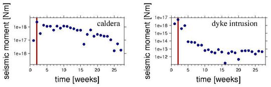
All in all, the moment release on the caldera rim has decayed by a factor of 10 - 20 since the end of August 2014. However, the current weekly moment release of about 1E17 Nm is still remarkable for a volcanic earthquake sequence.
17 February 2015 - number of events since the onset
Yesteday, there were six months since the onset of the current seismic activity 16 August 2014. A little later, volcanic activity began in Holuhraun. See an introduction to Bárðarbunga published at that time and a chapter on Bárðarbunga from a risk assessment (in progress). Below is a table with the number of events during these six months, and keep in mind that in ordinary circumstances only about 10,000 - 15,000 automatic events occur per year in Iceland:
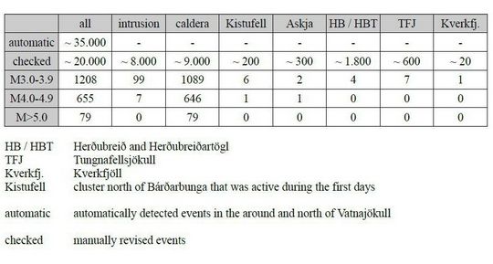
A new table (enlarge, pdf 30 Kb) with the approximate number of events and the total number of events over M3 in magnitude since the onset of the seismic events in northwestern Vatnajökull. The period is 16.08.2014 - 17.02.2015. For comparison an older table is available.
17 February 2015 11:00 - from the Scientific Advisory Board
Notes from the meeting of the Scientific Advisory Board (pdf 0.4 Mb). The volcanic eruption in Holuhraun continues. The eruption is still strong although it continues to diminish. No earthquake over M5.0 has been detected in Bárðarbunga since 8 January.
17 February 2015 12:00 - from geoscientist on duty
No obvious changes have been observed in the seismic activity at Bárðarbunga and in the dyke intrusion, as well as in the volcanic activity at the eruption site in Holuhraun since the last report, yesterday morning.
The strongest earthquake on the Bárðarbunga caldera rim was magnitude 3.6 yesterday at 11:13, all together about 15 events have been detected around the caldera. A total of 20 earthquakes were observed in the dyke intrusion, the strongest was magnitude 1.5 at 03:33 this morning. Low activity around Tungnafellsjökull, Askja and Herðubreið.
16 February 2015 - six months since the onset of seismic activity
Today, there are six months since the onset current seismic activity, see also an introduction to Bárðarbunga. A little later, volcanic activity began in Holuhraun. See overview of seismicity.
16 February 2015 10:00 - from geoscientist on duty
Seismic and volcanic activity around Bárðarbunga and at the eruption site in Holuhraun continue at similar levels as in previous days. The overall activity is persistent, but lower compared to recent weeks and months. No unusual observations have been made during the last 24 hours. Noise due to present storm condictions might though influence the seismic measurements and smallest earthquakes might not be detected.
Bárðarbunga: Around a dozen earthquakes have been detected around the caldera rim, the strongest one was M3.9 yesterday at 14:12.
Dyke intrusion: Six earthquakes were observed in the dyke intrusion, all of them M<1.5.
Other regions: A M2.2 earthquake occurred east of Herðubreið today at 03:29, all together around 10 events were detected in the same cluster.
15 February 2015 12:00 - from geoscientist on duty
A dozen earthquakes has been detected during the last 24 hours. The largest occurred at 16:37 yesterday, 2.1 in magnitude. Just under ten earthquakes have been detected in the dyke intrusion, all near or under 1 in magnitude. A few occurred in the Herðubreið area, the largest just over M1. Visibility towards the eruptive site was fair on webcams this morning, while still dark, and the eruption seemed of similar intensity as lately.

14 February 2015 12:00 - from geoscientist on duty
Around 20 earthquakes have been detected at Bárðarbunga during the last 26 hours. Three earthquakes above 4 in magnitude occurred at the northeastern rim of the caldera last night; the first one M4.3 at 21:13 but then a larger one ten minutes later (21:22), an M4.5, and the third two hours later, an M4.0 at 23:33. A dozen earthquakes occurred at the dyke intrusion, the largest an M1.7 at 13:26 yesterday (13 Feb.).
Seismic activity at Herðubreið and Herðubreiðartögl continued yesterday and this morning; over a dozen earthquakes in addition to the 30 documented in our last report, noon yesterday.

13 February 2015 17:10 - the access controlled area changed
A press release regarding the access controlled area North of Vatnajökull (pdf 0,5 Mb).
At the end of January The Icelandic Meteorological Office carried out a new hazard assessment for gas pollution from the volcanic eruption in Holuhraun. The new hazard assessment is based on the gradual decreased intensity of the volcanic eruption since October, seasonal weather conditions and regular monitoring of gas pollution at the eruption site. A model for weather conditions in the area over the last 10 years and given values of SO2 was also used in the hazard assessment. The risk map that now comes into effect is based on weather conditions in February until May and will be revised again before the summer.
The map of the restricted/closed area (red) and the hazard area (gray) (high resolution pdf 3.5 Mb).

13 February 2015 14:20 - from the Scientific Advisory Board
Notes from the meeting of the Scientific Advisory Board (pdf 0.4 Mb).
The National Commissioner of the Icelandic Police and Police Districts Commissioners in North East, East and Southern Iceland have decided (with reference to law on civil protection nr. 82/2008, article 23) to change the scope of the access controlled area north of Vatnajökull glacier. The decision is taken in close collaboration with the Icelandic Meteorological Office, Vatnajökull National Park, the Icelandic Environmental Agency and the Directorate of Health.
A map showing the new access controlled area and GPS coordinates can be seen on the web site of the Department of Civil Protection (scroll down for map). The restricted red area is completely closed and the hazard zone which surrounds it is in grey.
13 February 2015 10:00 - from geoscientist on duty
About 20 earthquakes have been detected at Bárðarbunga during the last 24 hours. No earthquake reached 3 in magnitude (although processing has not been completed yet). In the dyke intrusion a dozen earthquakes were detected, the largest M1.1.
At Herðubreið and Herðubreiðartögl, north of Holuhraun, a series of earthquakes began just after 2 o‘clock this morning with increased intensity after 05:30. About 30 earthquakes were detected in the area, the largest an M2.7 at 08:19. The activity has been decreasing during the last hour or so.
12 February 2015 10:00 - from geoscientist on duty
About 30 earthquakes have been observed in Bárðarbunga during the past 24 hours, a bit more than the day before that. The largest quake occurred yesterday at 12:16 M4.0. About ten quakes were observed in the dike intrusion, all about or less than magnitude 1. The eruption was visible on webcams this morning and the activity seemed similar to previous days.
11 February 2015 10:00 - from geoscientist on duty
Almost 20 earthquakes have been observed in Bárðarbunga during the past 24 hours. The two largest quakes were both of magnitude 3.8, at 11:44 yesterday and at 04:51 last night. About ten quakes were observed in the dike intrusion, the largest of magnitude 1.1.
10 February 2015 12:00 - from the Scientific Advisory Board
The volcanic eruption in Holuhraun continues; no scientists are in the area because of bad weather conditions. A team of scientists has been monitoring pollution in rainwater, snow and melt water since the eruption started. The team is planning to collect samples on Vatnajökull glacier and on mountain tops in Eastern Iceland. Chemical composition of rainwater around Iceland is also being monitored.
Notes from the meeting of the Scientific Advisory Board (pdf 0.4 Mb).
10 February 2015 10:00 - from geoscientist on duty
More than 20 earthquakes have been detected at Bárðarbunga in the last 24 hours. Two were over M4: An M4.7 at 03:18 this morning and M4.0 at 13:33 yesterday. Two earthquakes about M3.8 were detected in the early hours of the morning. Only a few small earthquakes were in the dike intrusion.
9 February 2015 10:00 - from geoscientist on duty
About 20 earthquakes have been detected at Bárðarbunga since noon yesterday. All were under M4; two were over M3 (M 3.8 and M3.2) and only a few small earthquakes in the dike intrusion. The eruption was visible in web cameras this morning.
8 February 2015 - the caldera subsidence scrutinized
Now, displacement velocities of GPS stations are compared over two different time periods in order to monitor the subsidence of the Bárðarbunga caldera closely and process data for long term research.
8 February 2015 12:00 - from geoscientist on duty
About 20 earthquakes were observed in Bárðarbunga during the past 24 hours. Two the largest were of magnitude 3.9, one at 16:38 yesterday and the other at 04:18 last night. Other quakes were not over magnitude 3. About 10 quakes were observed in the dike intrusion, the largest of magnitude 2.

7 February 2015 12:00 - from geoscientist on duty
About 20 earthquakes were observed in Bárðarbunga since yesterday morning at 10:00. Two quakes of magnitude about 4 were observed this morning; M4.1 at 07:05 and M4.0 at 07:20. A few quakes were between M3 and M4. About ten quakes were observed in the dike intrusion, of magnitude M1.5 or less.
6 February 2015 12:00 - from the Scientific Advisory Board
A visible reduction has been in the eruption during the last two weeks. Seismic activity in Bárðarbunga continues to be strong. Notes from the meeting of the Scientific Advisory Board (pdf 0.4 Mb)
6 February 2015 10:00 - from geoscientist on duty
Over 20 earthquakes were detected at Bárðarbunga during the last 24 hours, the largest M4.5 at 03:48 this morning; one earthquake M3.9. Only a few were detected in the dyke intrusion, all under M1.5.

5 February 2015 - IES notes from a surveillance flight
The Institute of Earth Sciences has sent notes from a surveillance flight 5 February 2015 (pdf 0.9 Mb).
5 February 2015 10:00 - from geoscientist on duty
About 25 earthquakes were detected at Bárðarbunga during the last 24 hours. The largest was M4.5 at 03:13 this morning. Three earthquakes were in the range M3 - M4. In the dyke intrusion only five earthquakes were detected, all under M1.5.
4 February 2015 - new equipment near Holuhraun
New equipment was installed near the eruptive site two weeks ago, a MultiGAS gas measuring instrument and a weather station. Both instruments transmit data to IMO, that is used for monitoring the eruption.
MultiGAS measures the gases H2O, SO2, CO2, H2S and H2 which will help with forecasts of future eruptive activity. The MultiGAS instrument is part of a collaboration with the University of Palermo, thanks to the Futurevolc project.
The weather station measures several local environmental parameters including wind speed and direction and humidity which helps to advise people working close to the eruption and in interpreting visual changes in the eruptive plume. The weather station is part of a collaboration with the British Geological Survey.
4 February 2015 10:00 - from geoscientist on duty
More earthquakes were detected in Bárðarbunga the last 24 hours than in the previous days. The largest earthquake was yesterday at 16:09, M4. Ten earthquakes between M3 and M4 were detected, and more than ten in the dyke intrusion, all under M1.5. The eruption eruption was clearly visible in web cameras.
3 February 2015 - photos from a surveillance flight
In a separate article, photos from a surveillance flight 3 February 2015 show both the gasplume, gas fumaroles from the center of the lava field far away from the craters, and photos of the eruptive site.
3 February 2015 12:00 - from the Scientific Advisory Board
Hardly any changes in the intensity of the eruption in Holuhraun have been detected over the last few weeks. GPS measurements near northern Vatnajökull ice cap show continuing slow deflation, with displacements towards Bárðarbunga. On Saturday (31 Jan.) around 2300 μg/m³ SO2 was measured in Höfn í Hornafirði. A new risk analysis for the area around the eruption site is being conducted.
Notes from the meeting of the Scientific Advisory Board (pdf 0.4 Mb)
3 February 2015 10:00 - from geoscientist on duty
Slightly more earthquakes than the days before - ca 45 - have been detected in Bárðarbunga the last 24 hours. The largest earthquake, M4.6, occurred last night at 21:35. Four earthquakes between M3 and M4 were detected. Ca 15 earthquakes have been detected in the dyke intrusion the last 24 hours, the largest one M1.9.
2 February 2015 10:00 - from geoscientist on duty
Seismicity in Bárðarbunga and the dyke intrusion is similar as last days. The eruption could be seen in webcams but disappeared sometimes in snowstorms. Ca 30 earthquakes were detected in Bárðarbunga since 12:00 yesterday, the largest ones this morning M4.1 at 08:00 and M4.0 at 08:09.
Less that 10 earthquakes were detected in the dyke intrusion, all ca or less than M1.0.
1 February 2015 12:00 - from geoscientist on duty
Once again, no significant changes in seismic activity during the last 24 hours. Webcam visibility is good and the eruptive activity seems quite stable. At Bárðarbunga, between 20 – 30 earthquakes have been detected, the largest an M4.4 at 08:18 AM. In the dyke intrusion a dozen small quakes has been detected. Two earthquakes occurred at Grímsvötn in Vatnajökull ice cap this morning (at 06:20 and 08:35), both about 1.2 in magnitude; but since then no further seismic activity has been detected there.

1 - 31 January 2015
Observations from the month of January are found in another comparable article, including a satellite image which shows that the size of the lava has exceeded that of lake Þingvallavatn.


