
Bárðarbunga 2015 - March, April, May
Seismic and volcanic events - the aftermath
Information on the aftermath of Bárðarbunga seismic events is given below (or pdf 0.71 Mb). The eruption in Holuhraun has ended but there are still gas emissions from the lava field; see notes and observations in March, April and May. New material is added to the top of the article. In combination, the monthly articles give an overview of events: August, September, October, November, December, January, February, March-April-May and the overview article (list of links).
Calendar
Below is a short-cut to additions in March, April and May plus an announcement 1st June.
March: 2-3-4-5-9-12-16-24-26. April: 1-3-8-11-16-24. May: 13-19. June 1.
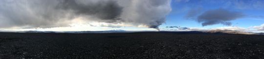 Panoramic view towards the eruptive site in Holuhraun 3rd September 2014. Photo: Richard Yeo.
New information
1 June 2015 - announcement
The Commissioner of the Icelandic Police, in collaboration with the district Commissioner of Police in North-Iceland east district, has lowered the alert level for the seismic activity in Bárðarbunga to Uncertainty Phase, which is the lowest level of three alert levels.
The area around Holuhraun is no longer closed. The lava field itself is however impassable and dangerous and attempts are not allowed. One of the tasks of Vatnajökull National Park is to lay out safe paths with time to come.
19 May 2015 - minor gas release
On May 19th a team from IMO reached Holuhraun lava field to make direct measurements of gases and modify instrumentation in the area.
Measurements inside the crater (where one and a half month ago up to 40 ppm of SO2 were measured) now only showed minor gas release, a maximum of 2 ppm of SO2 at the surface.
Some gases are being released through cracks in the lava, but it is hard to measure them properly. A temperature maximum of 250°C was measured inside a crack in the lava; however, most of the lava is so cool that the snow is covering some of the main crater.

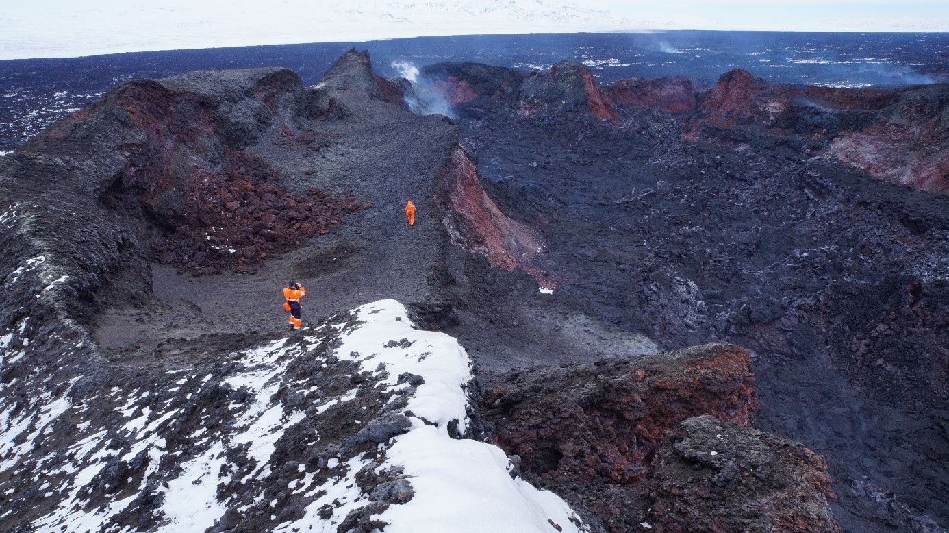
13 May 2015 - Holuhraun filmed by a drone
Assisted by the Institute of Earth Sciences in mid March, the Icelandic company Svarmi ehf filmed the Holuhraun lava field, using drones. The results are now available on their web-site, including: A striking 5 min. video showing a 3D model of the newly formed craters in Holuhraun (Svarmi ehf).
24 April 2015 - the Aviation Colour Code now green
IMO has changed the Aviation Color Code for the Bárðarbunga volcano from yellow to GREEN.
This decision has been taken in light of recent seismic and geodetic data from around the volcano, in addition to other measurements such as satellite-based thermal observations and radar-profiling flights.
Following the end of the Holuhraun eruption on 27 February 2015, Bárðarbunga has exhibited no further signs of escalating unrest. Seismicity levels within the volcano's caldera and the associated dyke intrusion continue to decline. Likewise, continuous GPS-based measurements in the region show that the volcano is not, for the moment, recharging with magma.
Bárðarbunga continues to be monitored closely and any significant change in the volcano's state will be reported immediately.
16 April 2015 - BBC reports on the voluminous gas
The BBC News "Science & Environment" reported yesterday on the estimation of the Bárðarbunga eruption gases, citing IMO's Sara Barsotti on the EGU General Assembly in Vienna, Austria, and referring to Magnús (Tumi) Guðmundsson of the Institute of Earth Sciences.
11 April 2015 - IES flight report since yesterday
From the Institute of Earth Sciences, University of Iceland:
Yesterday, 10 April, radar altimeter surveys were conducted from TF-FMS over Bárðarbunga, after six weeks of waiting for the right weather. The results obtained are:
- The depth of the caldera subsidence is the same as obtained with the BARC GPS station until contact was lost in March, the maximum being 62 m.
- The volume of the subsidence bowl is now 1.9 km³. This is an increase of about 0.1 km³ since 3rd February. It is likely that most of this volume increase occurred in Febuary.
- Geothermal activity:
-
- Ice cauldrons at the SE rim of Bárðarbunga are now 5-10 m deeper than they were in late January.
- The southern ice cauldron on the western rim is similar in depth as was two months ago, but it has grown wider. The northern cauldron on the western rim is unchanged since January.
- An ice cauldron, which formed on the SE slopes, outside the caldera, in late August in a short-lived subglacial eruption, has continued to grow. It was 10 m deep in September, 50 m deep in January and now the depth has reached 60 m.
The geothermal activity in Bárðarbunga has apparently not increased in the last two months, but more detailed analysis is needed before it will be known whether it has decreased. No signs, that could be interpreted as water accumulation under the ice, could be seen (neither uplift of cauldron floors nor significant uplift of the caldera center were detected).
11 April 2015 - tourists' interest
Iceland eruption trips are popular, according to the online version of Iceland Review, yesterday. However, precautions must be taken against the possibly hazardous fumes, see their earlier news: "Now that tourists can visit the Holuhraun eruption site, they must pay close attention to the levels of toxic volcanic gases in the area as the lava field will continue to degas for several months."
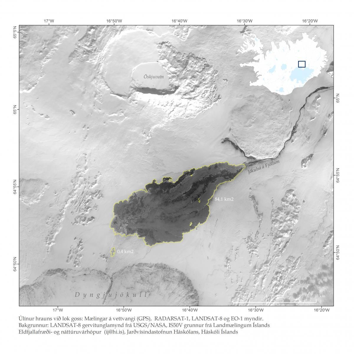
8 April 2015 - final outlines of the lava
The Institute of Earth Sciences, University of Iceland, has produced a map showing the final outlines of the Holuhraun lava field and provides data on the final extent of Holuhraun on the institute's web-site. References must be cited correctly, see the text below the map.

3 April 2015 - online sensors for sulphur gas

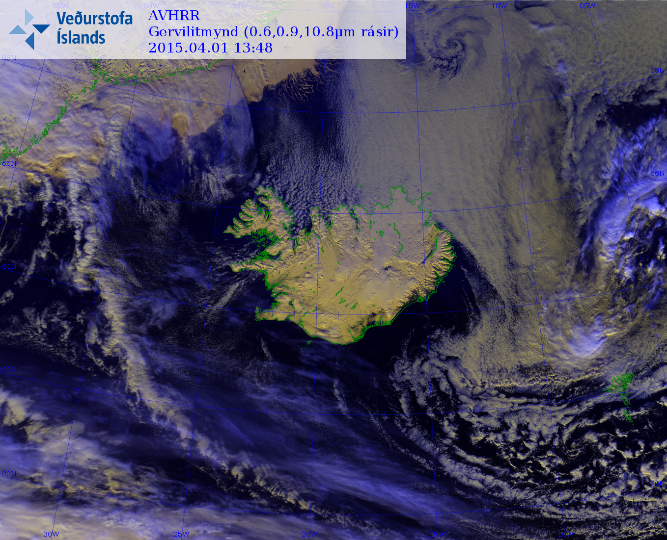
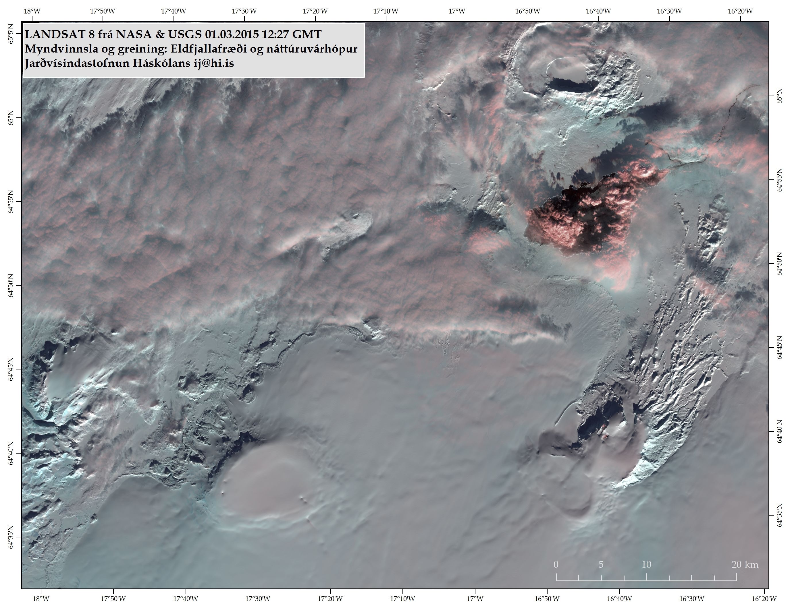
1 April 2015 - a satellite image

26 March 2015 - a gas report by IMO
A brief report on gas measurements in the field, 26 March 2015 by the Icelandic Meteorological Office: Within the crater, the concentration of SO2 was over 40 ppm but the release was localized and wind conditions did not allow any significant spreading. While walking across the lava field to the crater, no SO2, CO or H2S was detected. A little earlier, a webcam was mounted by Flæður.

24 March 2015 - a field report from IES
The Institute of Earth Sciences has presented a field report from the eruption site, 17 - 19 March 2015, during which aerial survey mapping was made, using a fixed-wing drone. Profiles with kGPS were also walked across and along the lava dam between the older Þorvaldshraun and the new Holuhraun, collecting data for modelling of flooding on Flæður. A steam field in the far ENE part of the lava is still active. By the crater and along the lava channel, concentrations of 0.3 - 0.9 ppm SO2 were measured.


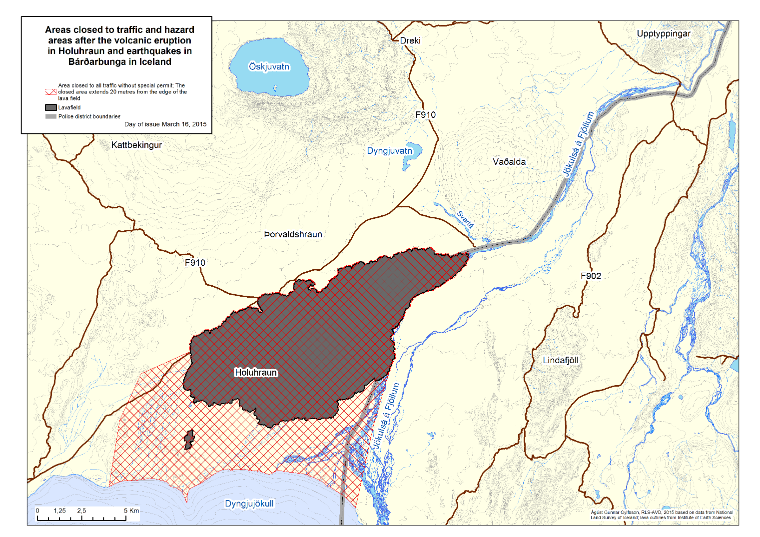
16 March 2015 - reduction of the access controlled area
The Police District Commissioners in North Eastern, Eastern, Southern Iceland, and the National Commissioner of the Icelandic Police have decided to change the restricted area in Holuhraun, see press release (pdf 0.9 Mb).
This decision is based on a risk assessment from the Icelandic Meteorological Office covering risk factors in the area. The Icelandic Meteorological Office has also proposed countermeasures to increase public safety close to the restricted area.
The Police, in cooperation with Vatnajökull National Park, will provide a presence in the area to secure public safety, in close collaboration with the Icelandic Meteorological Office. These institutions will try to install further monitoring equipment to add to the existing monitoring system in the area to increase monitoring so that warnings may be issued if necessary.
Vatnajökull National Park will issue locations of viewing areas. Information on evacuation routes will be issued by officers on site.
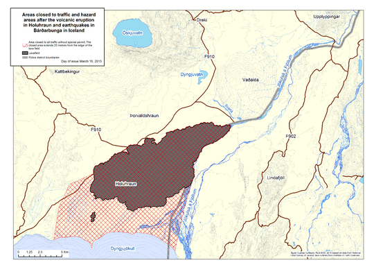 The restricted area extends 20 m outside the edges of the new lava field, to the edge of Dyngjujökull glacier on the south side, the river Jökulsá á Fjöllum to the east and to the westernmost branches of Jökulsá á Fjöllum in the west. Enlarge.
12 March 2015 - from the Scientific Advisory Board
Notes from the Meeting of the Scientific Advisory Board 10 March (pdf 0.3 Mb) are now available. No further meetings are booked; the board will convene when needed. The main points of the meeting are:
- The hazards that may still be relevant, following the events in Bárðarbunga and Holuhraun, were discussed.
- More equipment must be installed in the area, and the monitoring of the Icelandic Met Office must be secured, before the area is opened for the public.
- Counter-measures to reduce risk in the area will be taken and decisions on further opening of the area will then be made.
- The Aviation Colour Code for Bárðarbunga was changed from orange to yellow when the eruption ended.
5 March 2015 - field trip yesterday

4 March 2015 - field report with photos
A two day field trip, 3 March and 4 March 2015, was made in order to improve gas measurements and tend to various equipment; see two reports (in English) with photographs (pdf 0.7 Mb).
3 March 2015 - surveillance flight confirmed the end
Last week, Thursday evening 27 February, a surveillance flight was made in order to confirm the news that no glow was visible on webcams at Holuhraun. It was too dark to take any photographs.
According to thermal measurements (FLIR, IES) there was still considerable heat on the rims of the crater but colder at its bottom. A gas detector showed max 0.5 ppm SO2 in flight and max 0.4 ppm when tested on ground, at the southwestern edge of the lava field.
In the northeastern part of the lava field there were still embers in old outbreaks; the maximum temperature detected was 560°C (compared to 1200°C before). After comparison with other data at the Met Office it is concluded that probably the eruption ended early morning 27 February.
3 March 2015 - from the Scientific Advisory Board
The volcanic eruption in Holuhraun came to an end on Friday 27th of February.
Scientists are now analysing data and examining the eruption site to reassess the hazard assessment. It was decided to use this week for that assignment. The Scientific Advisory Board will meet again next Tuesday, 10th of March, based on that meeting it will be decided if the hazard assessment and the restricted area will be changed.
Notes from the Meeting of the Scientific Advisory Board (pdf 0.4 Mb)
2 March 2015 - gas emissions continue
The eruption in Holuhraun has come to an end but the Icelandic Meteorological Office still monitors gas dispersal closely. Other lava eruptions have taught that the lava field continues to emit gas for a long time yet and without the thermal rise from an open vent, the volcanic gases will tend to follow the ground. Therefore, even higher values of more polluting gas may be expected now than in recent weeks.

1 - 28 February 2015
Observations from the month of February are found in another comparable article, including a declaration from the Scientific Advisory Board that the volcanic eruption in Holuhraun has come to an end and that gas emissions still continue.
This March-April-May article can be downloaded as pdf (0.71 Mb).


