Navigation
.
Listen
Articles
© Veðurstofa Íslands
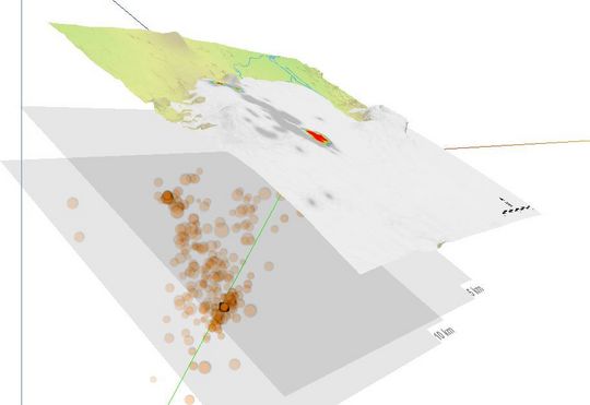
Skjáskot úr þrívíddarlíkani af jarðskjálftahrinunni í Bárðarbungu 2014. Þetta er tilraunaútgáfa og líkanið enn í þróun. Tryggvi Hjörvar, starfsmaður Veðurstofu Íslands, gerði þetta líkan.
MODEL
Of interest - Bárðarbunga
Reduction of the access
controlled area around Holuhraun lava field
END OF ERUPTION declared
by the Scientific Board
Location map (detailed)
around the new lava field
Bárðarbunga earthquakes
3D interactive model
Thickness and volume
estimate from January 1st
Comparing historic sizes of lavafields: AD 934 and 1783
Gas dispersion model
Preliminary
flood risk assessment
for Jökulsá á Fjöllum
Web cameras of Míla
Web cameras of M&T
Related topics
Instructions on using earthquake pages
Bárðarbunga and Holuhraun 2014-2015 - overview
Grímsvötn 2011 - overview
Eyjafjallajökull 2010 - overview
Useful links
FutureVolc
Road conditions
Earthquake Engineering Research Centre - University of Iceland
Incorporated Research Institutions for Seismology
National Earthquake Information Center
Preventive response to earthquakes
You are here:
Home
>
Earthquakes
>
Articles
en.vedur.is
Home
Weather
Earthquakes
Hydrology
Avalanches
Climatology
Sea ice
Pollution
About IMO
Earthquakes
Earthquakes - all regions
Volcanoes
Catalogue of Icelandic Volcanoes
Tremor measurements
Strain measurements
Deformation Measurements
Articles
Reports and publications
Conferences
Response to earthquakes
Other institutions
Reykjanes
Search
Search string
Other related web sites
Icelandic
Mobile web
This website is built with
Eplica CMS