
Update on volcanic activity in Grímsvötn
Status reports, photos and facts
30 May 2011 - 15:00
Collective status report (pdf 20 Kb) of the Institute of the Earth Sciences and of the Icelandic Meteorological office was published at 14:00.
Saturday morning at 6:30 UTC the volcanic tremor on Grímsfjall (Grímsvötn) rapidly decreased and had disappeared at 7 UTC. Since Thursday the tremor had been intermittent. Today, Monday 30 May, it has been confirmed by the participants of Iceland Glaciological Society's spring expedition that the eruption has ended.
The end of the Grímsvötn eruption is set to 7 UTC Saturday morning 28 May 2011.
26 May 2011 - 17:45
Collective status report (pdf 44 Kb) of the Institute of the Earth Sciences and of the Icelandic Meteorological office was published at 16:00. Status reports will no longer be sent on a regular basis, only if something notable is observed.
Plume is no longer detected on radar at 70 km distance from the eruption site although minor steam explosions are observed in the crater. Ashfall occurs only in the vicinity of the eruption site.
Visual observations of Grímsvötn show that little ice has melted during the eruption, meaning that an outburst flood (jökulhlaup) is not to be expected. Long-term conductivity measurements of Gígjukvísl suggest that meltwater is draining freely from Grímsvötn following a jökulhlaup from the lake last autumn.
Explosive activity was observed near the ice-wall just south of the crater/fissure where the main activity has been. Overall assessment: Very little changes since yesterday. Explosions continue, only affecting the area around the crater.
26 May 2011 - 14:45
Yesterday, a group walked towards the eruptive site. Surveillance revealed much ash west and south of Grímsvötn. A few measurements, at locations where the ice was completely covered, gave ash thicknesses varying from 10 to 130 cm. Photo by Vilhjálmur Kjartansson, 25. maí 2011:
25 May 2011 - 18:05
Collective status report (pdf 35 Kb) of the Institute of the Earth Sciences and of the Icelandic Meteorological office was published at 16:00.
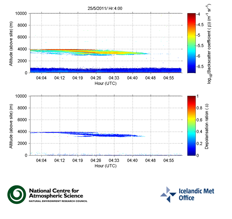
After 2:20 UTC the plume has not been detectable on radar, except for a steam plume at 3:30 which reached 5 km. Eyewitnesses have reported small steam bursts from the crater today. Widespread ash in cloud layers has been detectable 5-7 km west of the volcano.
Yesterday evening there was still active explosivity in Grímsvötn (see photo collection). The activity is in three to four tephra cones surrounded by meltwater. The activity is pulsating with explosions producing ash clouds that rise up from the craters, some reaching a few kilometers. The eruption plume is not continuous and all the material falls out nearby.
All measurements and aerial observations show that the eruption has diminished substantially. Ash-fall is now confined to the vicinity of the eruption site.
 Photo: Árni Sigurðsson, Tuesday evening 24 May 2011.
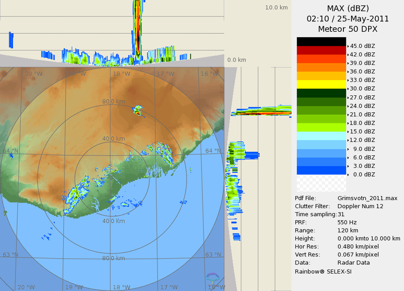
25 May 2011 - 15:00
The ash plume reached about 5 km at 21 hrs last night; at 02:10 this morning it reached the height of 12 km and then subsided. Lightnings were detected. At about 04:00 a steam plume up to 5 km high was observed, but after that steam only reached 100-300 m height. IMO has reported to London Volcanic Ash Advisory Centre that no ash plume is being detected and is not expected. Seismic tremor fell after 21 hrs last night and again at 02 last night, but is still being recorded at the Grímsfjall station and stations near the volcano. No earthquakes are being recorded.
24 May 2011 - 17:30
The ash plume has not been visible on radar due to weather conditions at the eruption site and around it. The estimated height is below 5 km since clouds over the glacier were at 5-7 km and the plume did not reach above the cloud deck. Seismic tremor at the Grímsfjall station has been fairly stable since yesterday afternoon. No earthquakes were recorded in the volcano today.
See status report of IMO and the Institute of the Earth Sciences at 17:00.
The IMO has a mobile weather radar on loan from the Italian Civil Response Authorities. When Grimsvötn erupted it was placed near the village Kirkjubæjarklaustur, about 80 km from the volcano. The weather radar is used to monitor changes in the height of the volcanic plume, but those are indicative of the strength of the eruption.

The radar image from 9:40 AM on Thuesday May 24th shows the location of the volcanic plume (see thin circle). It is significantly weaker than in previous days, and does not reach 5 km altitude. During the early stages of the eruption it reached more than 20 km altitude, but in recent days it has been ranging from 5 to 10 km altitude.
23 May 2011 - 19:00
Collective status report (pdf 37 Kb) of the Institute of the Earth Sciences and of the Icelandic Meteorological office was published at 17:00.
In the last hours, the plume has reached heights of 5 to 9 km, but northerly winds have been very strong which can effect the height. The amount of fallout is great from Vík in the west to the east of Öræfajökull. The amount of ash fall is the greatest close to the village Kirkjubæjarklaustur. Ash has been detected in several areas throughout the country, except in the northwest. The eruption has abated slightly since yesterday. No effusion of lava has been observed.
22 May 2011
The altitude of the plume is monitored by two weather radars, one located in Keflavík International Airport 220 km from the volcano, and a mobile one currently situated approx. 80 km away from the volcano.
Initially the plume reached approx. 20 km altitude but during the night it fell to 15 km, occasionally rising to 20 km. During the morning of the 22nd the plume was lower still, or at around 10 km in altitude, rising occasionally to 15 km.
Collective status report (pdf 61 Kb) of the Institute of the Earth Sciences and the Icelandic Meteorological Office was issued at 17:00.
21 May 2011
An eruption began at Grímsvötn volcano at approximately 17:30 UTC, May 21st 2011. Eruptions in Grímsvötn start as subglacial eruptions, which quickly break the ice cover. At 21:00 UTC, the eruption plume had risen to an altitude of over 65,000 ft (~20 km). The last eruption in Grímsvötn occurred in November 2004. Grímsvötn is Iceland's most frequently erupting volcano.


