
Earthquakes
Earthquakes
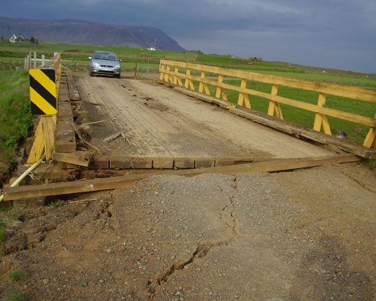
The brigde crossing the Sandá river, Ölfus, was damaged by an earthquake 29 May 2008. Photo: Sigurlaug Gunnlaugsdóttir.
In order to be able to predict an eruption, or issue a public warning on imminent eruption, it is important to monitor the Earth's crust with a dense network, especially where volcanoes are located to near inhabited areas.
Volcanic areas are usually characterized by seismicity, which can be very different for example in intensity and magnitude between different volcanoes and whether the volcano is at rest or active. But earthquakes or changes in seismicity can be a strong indicator on an imminent eruption. By collecting seismic data on long term it is possible to acquire knowledge on how volcanoes behave seismically and learn to know which changes are likely to lead to and eruption at each volcano. Earthquakes at volcanoes are usually smaller in magnitude than those that occur at
Active volcanic zones are usually followed with some earthquake activity. This activity can vary significantly between volcanic systems and also if the volcanic system is dormant or quite active at the time. But earthquakes and changes in earthquake activity can be a strong indicator of imminent eruptions. By collecting earthquake data from each volcanic system for a long period of time the system can be studied and the knowledge from that study on how the volcanic system acts will help in learning how to notice those changes which could likely lead up to an eruption. Earthquakes in volcanoes are usually quite smaller than the once which are measured in the fracture zones, and are hardly larger than M 5-6.
Hekla volcano is one of Iceland's most active volcanoes. Earthquake activity in the vicinity of Hekla is usually quite low, but seems to increase abruptly before an eruption. Before the eruption in Hekla in 2000, increased earthquake activity was measured in the area and a seismic swarm occurred just about an hour before the eruption. In addition to the earthquake activity, there were some significant changes in nearby strain meters and because of that an warning could be sent out to the public about an imminent eruption about half an hour before the eruption started. In other volcanic system in Iceland there are examples of prolonged intrusion activity before the magma reaches the surface. In the eruptions in Eyjafjallajökull in 2010 and in Holuhraun-Bárðarbunga in 2014-2015, the seismic activity could be mapped thoroughly showing how the magma was moving beneath the surface for weeks and months before it erupted. This was mapped with quite accurate locations of thousands of earthquakes which were measured while the magma was making its way through the crust. Changes in the crust were also measured with GPS and InSAR measurements. Earqhquakes within the Grímsvötn volcanic system have been indicators for both short term and long term precursors of eruptions. For the last eruptions there, increased earthquake activity has been seen at least a year before an eruption, which than changes to a more intense seismic swarms hours before an eruption.
Increased vibration in the earth which is measured on seismographs is usually called a tremor, or increased tremor. This type of tremor if often seen in the beginning of eruptions when the magma is breaking its way up to the surface and when an eruption is ongoing. Volcanic tremor is usually even stronger when there is an eruption beneath a glacier (i.e. Grímsvötn), in those cases there is interaction between the magma and melted ice which increases the explosive activity in the eruption.
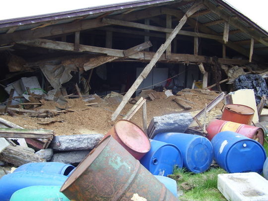
Barn at the farm Kross after earthquake in May 2008. Photo: Sigurlaug Gunnlaugsdóttir.
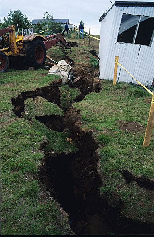
One of several fractures caused by an earthquake (M 6,2) on the southern lowlands, June 17 2000. Ljósmynd: Oddur Sigurðsson.


