
Bárðarbunga 2014 - October events
Seismic and volcanic events 1-31 October
The October observations (pdf 1.09 Mb) of the Bárðarbunga seismic and volcanic events are given here with daily notes, factsheets and additional material. Information, day by day, is given in reversed order. In combination, the monthly articles give an overview of events: August, September, October, November, December, January, February, March-April-May and the overview article (list of links).
Calendar
Below is a calendar with a short-cut to each day of this month's events:
Oct.: 1-2-3-4-5-6-7-8-9-10-11-12-13-14-15-16-17-18-19-20-21-22-23-24-25-26-27-28-29-30-31
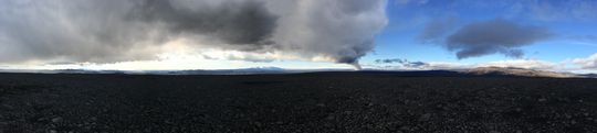 Panoramic view towards the eruptive site in Holuhraun 3rd September 2014. Photo: Richard Yeo.
Updated information
31 October 2014 - an article in Nature
Nature, the international weekly journal of science, has published an article on these events, called Gas-spewing Icelandic volcano stuns scientist - sulphur rich eruption defies preparations for an ashy blast, by Alexandra Witze.
31 October 2014 12:00 - from the Scientific Advisory Board
Conditions at Bárðarbunga are unchanged regarding earthquakes, subsidence and gas pollution. The energy of the geothermal areas in Bárðarbunga is now few hundred megawatts and the melting of water is estimated around 2 cubic meters per second. The water goes into Skjálfandafljót og Jökulsá á Fjöllum. The flow is too small to effect the total water flow of the rivers.
Notes from the meeting of the Scientific Advisory Board (0.4 Mb)
31 October 2014 10:00 - from geoscientist on duty
Over 80 earthquakes have been observed in the Bárðarbunga area past 24 hours. The largest was of magnitude M5.3 at 01:30, the first over magnitude 5 since Tuesday. A few quakes were over magnitude M3. Also a few in the northern part of the intrusion.
Currently the eruption site is not visible on webcams due to poor visibility.
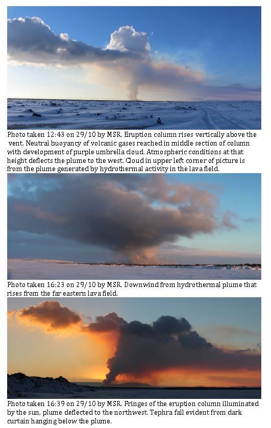
30 October 2014 - plume photos
In a field report from the Institute of Earth Sciences there are photos of the plume with explanations (taken 29 October by Morten S. Riishuus).
30 October 2014 10:00 - from geoscientist on duty
The last 24 hours the seismicity in Bárðarbunga has been a slight more than the day before. More than 100 earthquakes have been detected, all under M5. Ca 10 were larger than M4. The largest one was M4.6 at 16:09 yesterday. Ca 10 quakes were between 3 and 4. Seismicity in the northern part of the dike is similar to last days.
Visibility to the eruption is good and no changes can be seen.
29 October 2014 - yesterday's surveillance flight
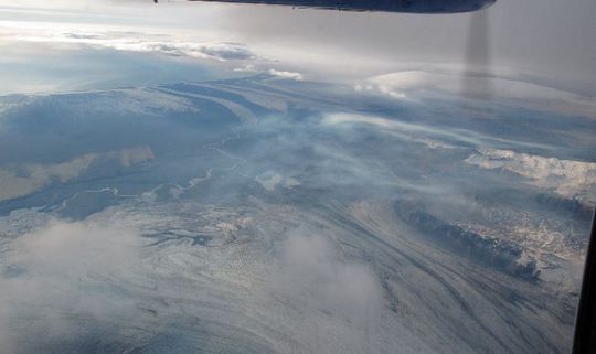
Photogalleries from flight 24 Oct and flight 10 Oct, are given as links under the appropriate date.
An extract from the flight report
On October 28th a reconnaissance flight was made with the Icelandic Coast Guard's aircraft, TF-SIF. The main objective was to observe any changes to the eruption site in Holuhraun and the caldera in Bárðarbunga as well as observation of volcanic gas emission and dispersion.
Over the western part of Iceland the cloud cover was broken and layered. The lowest layers had a cloud ceiling of 2000 feet, the second layer between 6000-9000 and a third layer at flight level around 19000 feet. The clouds slowly dissipated to the south.
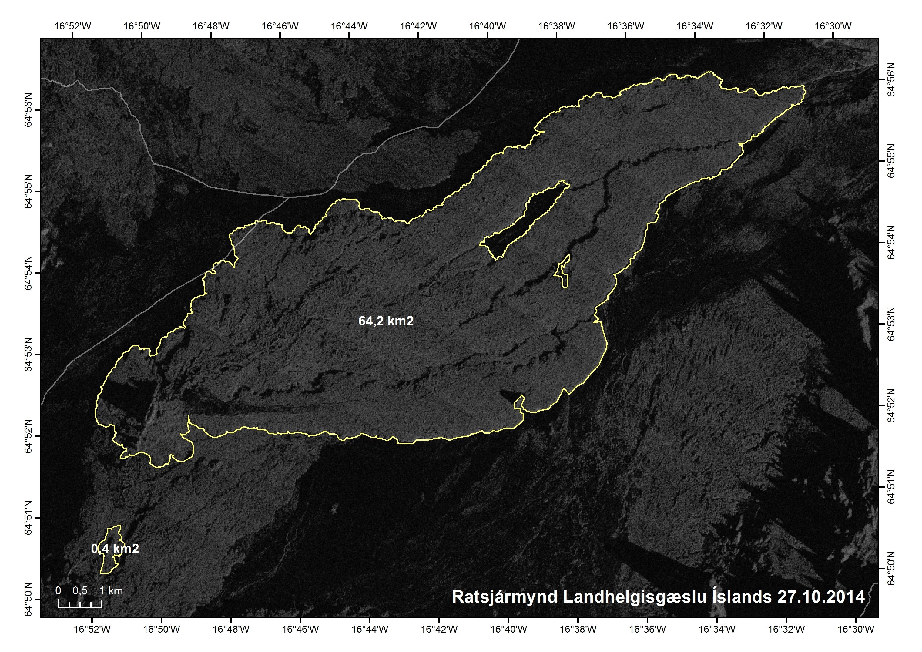
The flight was directed to the northeast from Reykjavik airport, north towards Hofsjokull and Askja. A large circle was then flown around the Bárðarbunga caldera and Holuhraun. In the later part of the flight the area south of Vatnajökull as well as the south coast were monitored for gas pollution.
Volcanic gas dispersion was quite extensive. Almost no pollution was seen around Reykjavík during take off. Northeast of Þingvellir a white or light brown gas cloud became visible on top of the cloud cover, aggregating in the troughs. The gas seems to drift in bands or veils that are not continuous, with clean air in between the veils.
Further towards Vatnajökull glacier the gas waves increased. From the west side of Vatnajökull visibility was good to the far east where blue haze in may separate layers was visible and extended quite far in both directions.
The blue haze was extensive in wave like form to the south and southwest of the glacier. The haze seems to aggregate between the outlet glaciers on the leeward of the glacier in the north wind.
Just to the west of Vatnajökull there was a break in the pollution, but it was again visible closer to Mýrdalsjökull glacier. The ocean south of the island was covered in haze, bluish or brown and the haze seemed to drift far to the west.
It seems that the pollution builds up over a period of days. The gas cloud was not continuous from the eruption site and seemed to be quite stationary in some places, especially around the outlet glaciers on the south sides of Vatnajökull.
29 October 2015 12:00 - from the Scientific Advisory Board
Seismic activity in Bardarbunga continues to be strong.130 earthquakes have been detected in the caldera over the last 48 hours.
Notes from the meeting of the Scientific Advisory Board (0.4 Mb)
29 October 2010 10:00 - from geoscientist on duty
About 80 earthquakes have been located in the Bárðarbunga area past 24 hours - similar amount as the 24 hours before. Four earthquakes were over M4.0:
28 Oct. 09:37 M4.6
28 Oct. 13:01 M4.6
29 Oct. 02:29 M4.6
29 Oct. 05:23 M4.8
Earthquakes over M3.0 were more than 10 and activity in the northern part of the dike is similar as last days. Visibility is good at the eruption site and according to webcams the eruption is ongoing at similar rate as before.
28 October 2014 10:00 - from geoscientist on duty
About 80 earthquakes have been located in the Bárðarbunga area past 24 hours. Two quakes were over magnitude 5 in the northern caldera rim this morning, one M5.0 at 04:54 and the other M5.1 at 06:04. Additionally, few quakes over magnitude 4 have been observed, but manual processing of these is not finished. Over ten quakes were located in the northern part of the dike intrusion. The eruption was observed on webcams a few times during the night, last observation was at about seven and the eruption seems at a similar pace as before. Currently there is poor visibility in the area and the eruption not visible on webcams. (See next day for this day's flight report).

27 October 2014 12:00 - from the Scientific Advisory Board
Geothermal heat is increasing. A cauldron in the southeast corner of Bárðarbunga has deepened about 25 meters. This is thought to be linked to the subsidence of the Bárðarbunga caldera.
Notes from the meeting of the Scientific Advisory Board (pdf 0.4 Mb)
27 October 2014 10:00 - from geoscientist on duty
Just over 60 earthquakes have been detected in and near Bárðarbunga during the last 22 hours. The largest occurred at 01:05 this morning, M5.3 at the southwestern rim. Two quakes over 4 occurred at the caldera, an M4.6 at 17:34 yesterday and an M4.3 at 05:48 this morning, as well as a few over 3 in size. A dozen earthquakes were detected in the dike, all small.
26 October 2014 12:00 - from geoscientist on duty
Approximately 80 earthquakes have been detected around the Bárðarbunga caldera. The strongest events were M5.3 today at 05:48 on the southeastern caldera rim and M4.7 yesterday at 12:10 on the northern rim. Seven additional events were larger than M4 and around five between M3.0-3.9.
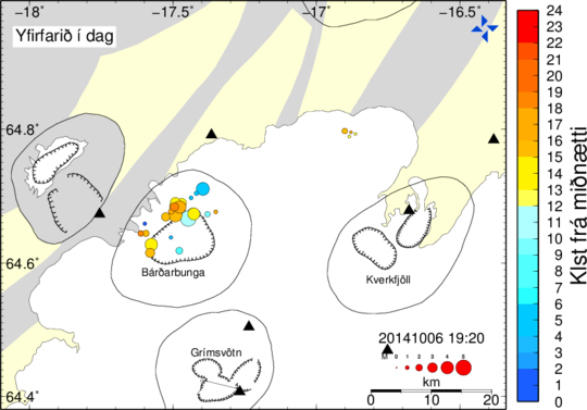
Seismic activity on the caldera rim has significantly decreased in terms of number and strength of events following the M5.3 earthquake this morning. Temporary low activity has previously been observed for several M>5 events and can not be interpreted as a decrease of the overall activity. The subsidence rate of the caldera had shortly increased around one hour after the M5.3 and is now again back to normal rates, see graph, which also is a frequent observation associated with M>5 earthquakes in Bárðarbunga.
Around 20 events have been detected in the northern part of the dyke intrusion; the strongest was 2.1 at 11:51 yesterday. Activity has been low around Tungnafellsjökull, Herðubreið and Askja during the last 24 hours. The eruption ongoing, but rarely visible so far today.
25 October 2014 12:00 - from geoscientist on duty
Seismic activity on the Bárðarbunga caldera rim continues at comparably high rates as in recent days. Activity in the dyke intrusion was rather low during the last 26 hours since the last report, seismicity around Herðubreið has slightly decreased.
Approximately 110 earthquakes have been detected around the Bárðarbunga caldera. Strongest events were M5.2 today at 01:48 on the northern caldera rim and M5.0 yesterday at 10:23 on the north-eastern rim. Additionally, seven earthquakes were in the range of M4.0-4.9 and a dozen M3.0-3.9.
Around 25 events have been detected in the northern part of the dyke intrusion, all below M1.5. About 20 earthquakes were detected around Herðubreið, none of them exceeded M2.0. No visual observation of the eruption so far today.
24 October 2014 - surveillance flight
Photos are available from the surveillance flight 24 October 2014.
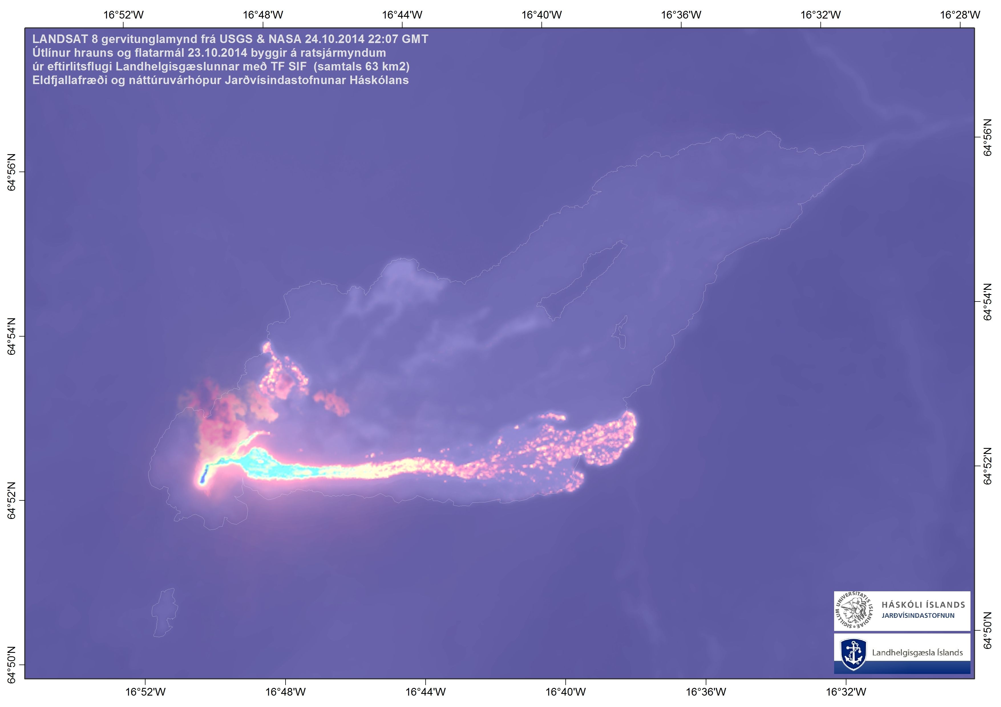
24 October 2014 - glowing lava stream
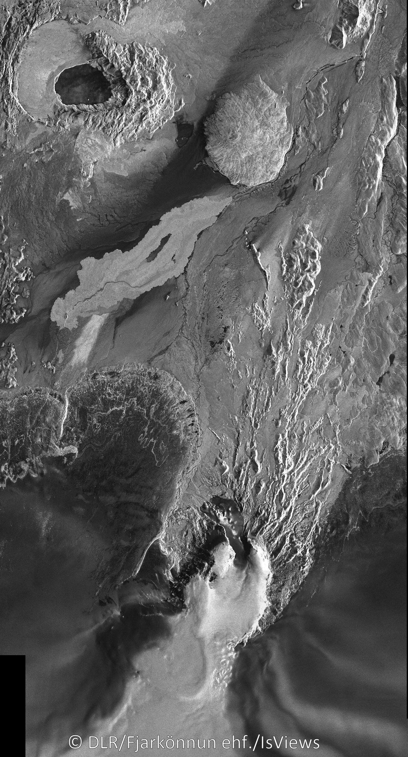
A thermal image from USGS and NASA, 24 October at 22:07, shows the lava stream due east and the progression of the margins toward east and north (outlines since 23rd). The plume appears as a thermal source also, drifting northwards, but this is gas only, not lava. Institute of Earth Sciences.
24 October 2014 11:30 - from the Scientific Advisory Board
Notes from the meeting of the Scientific Advisory Board (pdf 0.4 Mb)
24 October 2014 10:00 - from geoscientist on duty
Similar seismic and volcanic activity around the Bárðarbunga system as during the last days.
On the Bárðarbunga caldera rim about 70 earthquakes were detected in the last 24 hours, the strongest event was magnitude 4.8 at yesterday at 13:07. In addition to this earthquake, seven events were larger than magnitude 4 and around 25 between magnitude 3 and 3.9. Around 20 events have been detected in the northern part of the dyke intrusion, the strongest one was magnitude 1.9 last night at 02:48.
Approximately 35 earthquakes were detected southeast of Herðubreið, four of them exceeding magnitude 2, the strongest magnitude 2.8 at 19:15 yesterday evening. No visual observation of the eruption so far this morning.

23 October 2014 10:00 - from geoscientist on duty
No significant changes are observed in the seismic activity around the Bárðarbunga volcanic system.
Around 70 earthquakes occurred on the Bárðarbunga caldera rim in the last 24 hours, the strongest events were magnitude 4.8 at yesterday at 13:21 and magnitude 4.6 at 01:36 this morning. All together 7 earthquakes exceeded magnitude 4 and 15 events were in the magnitude range 3-3.9. Subsidence of the caldera continuous. Two earthquakes of magnitude ~3.5-4.5 in Bárðarbunga just right now (09:48 and 09:50).
Around 30 events have been detected in the northern part of the dyke intrusion, between northern Dyngjujökull and the eruption site in Holuhraun. The strongest were both magnitude 1.4 yesterday at 10:07 and 13:33.
A magnitude 3.0 earthquake occurred southeast of Herðubreið yesterday afternoon at 17:04, around 10 smaller events have preceded and followed this event. The region around Herðubreið and Herðubreiðartögl has been moderately active in recent days. Although this activity might be a response to increased stress due to the dyke intrusion, the region has been frequently active in the past and a direct link between the intrusion and the present activity is not obvious. No activity was observed under Tungnafellsjökull.
The last visual observation of the eruption was around 05:45 this morning.
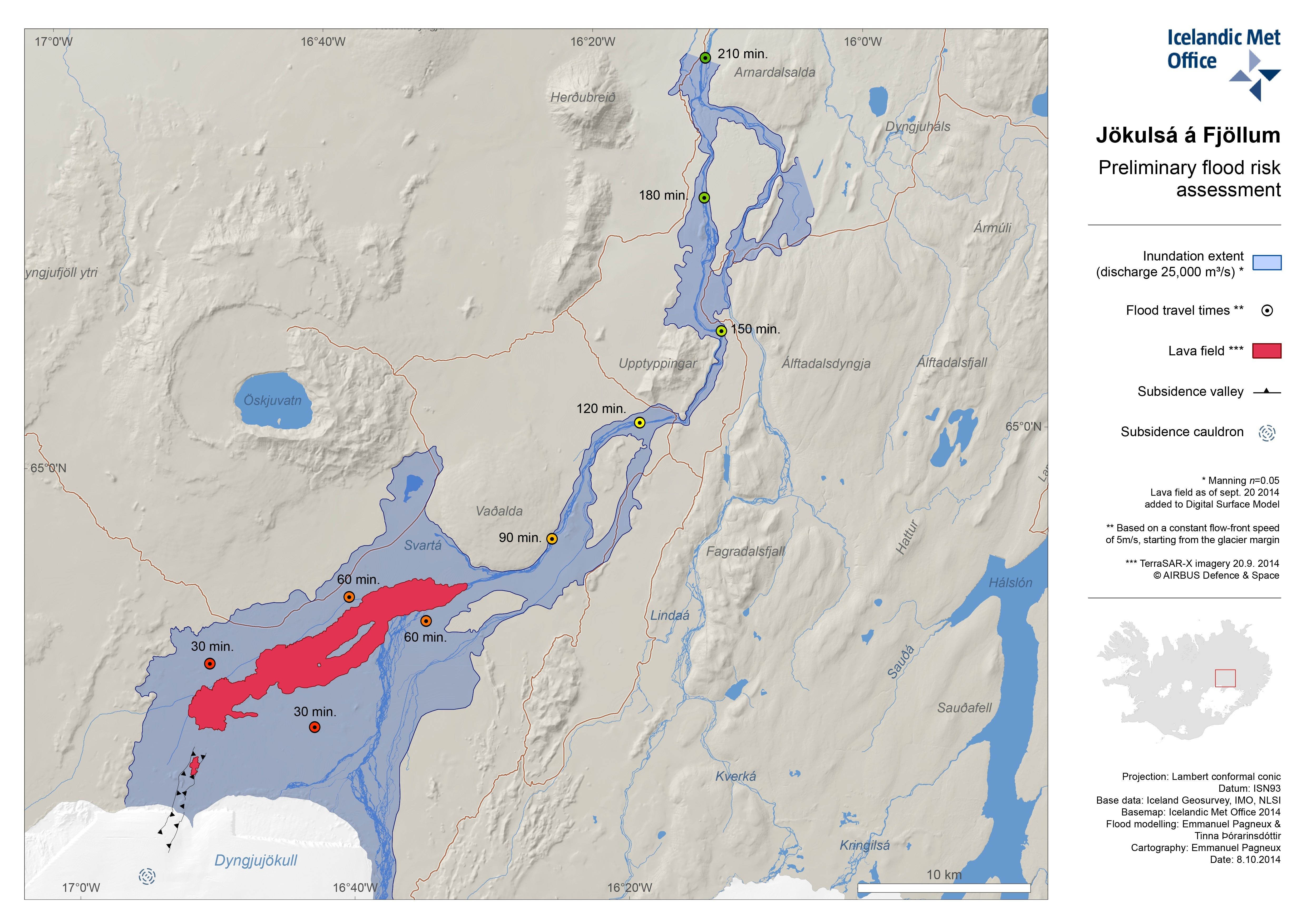
22 October 2014 - preliminary flood assessment
Preliminary flood assessment for Jökulsá á Fjöllum is now available. Inundation extent is given and flood travel times, given certain criteria.
22 October 2014 11:40 - from the Scientific Advisory Board
Notes from the meeting of the Scientific Advisory Board (pdf 0.4 Mb)
22 October 2014 10:00 - from geoscientist on duty
Seismic activity in the Bárðarbunga system and volcanic activity at the eruption site in Holuhraun is continuing at comparable levels as in recent days. No significant changes are observed. About 50 earthquakes occurred in the Bárðarbunga caldera rim in the last 24 hours, strongest events were magnitude 4.9 at 09:11 and magnitude 4.8 at 05:24 this morning. Three additional earthquakes exceeded magnitude 4 since yesterday morning, nine were between 3 and 3.9. Subsidence of the caldera continues.
About 30 events have been detected in the dyke intrusion since yesterday morning, the strongest one was magnitude 1.2 at 20:47 yesterday evening. The vast majority of events in the dyke was located between the northern part of Dyngjujökull and the eruption site in Holuhraun, very few events further south-west. Minor seismic activity is oberved around Herðubreið, about 10 events, all magnitude smaller than 1.5. Very low activity is observed in Tungnafellsjökull after being seismically quite active before last weekend.
The eruption continues, webcam observations (visibility good until about 07:30 this morning) and reports from scientists in the field do not suggest any changes in activity.

21 October 2014 10:00 - from geoscientist on duty
Seismic activity in the Bárðarbunga system and volcanic activity at the eruption site in Holuhraun has been comparable to recent days. During the last 24 hours around 70 earthquakes have been detected around the Bárðarbunga caldera rim, the strongest was magnitude 5.3 at 08:36 this morning on the northern rim. The event was preceded by a magnitude 4.7 in the same area just two minutes before. Four additional events exceeded magnitude 4 since the last report yesterday.
Earthquakes over M4.0 the last 24 hours:
20 Oct. M4.6 at 13:27
20 Oct. M4.1 at 13:30,
20 Oct. M4.7 at 13:31
20 Oct. M4.6 at 22:18
21 Oct. M 4.7 at 08:34
21 Oct. M 5.3 at 08:36
12 events were in the range of magnitude 3.0-3.9. The subsidence of the caldera continues at similar rates as the days before, no obvious step in subsidence was observed for the M5.3 earthquake this morning. Earthquake rates in the dyke intrusion are rather low, around 20 events have been detected in the last 24 hours, the strongest one was magnitude 1.4 yesterday at 23:31. All events in the dyke were located between the northern part of Dyngjujökull and the eruption site in Holuhraun.
The eruption continues, visibility on webcams was limited this morning due to weather.
20 October 2014 14:00 - from the Scientific Advisory Board
Notes from the meeting of the Scientific Advisory Board (pdf 0.4 Mb)
20 October 2014 10:00 - from geoscientist on duty
Seismic activity at Bárðarbunga is still high. An earthquake, M5.1 occurred at 08:54 this morning in the northern rim of the caldera. Some earthquakes between 4 and 5 occurred the last 24 hours. The eruption site was visible on webcams in the night and this morning, but currently no visibility is in the area and nothing can be seen through webcams.
19 October 2014 - the extent of the lava
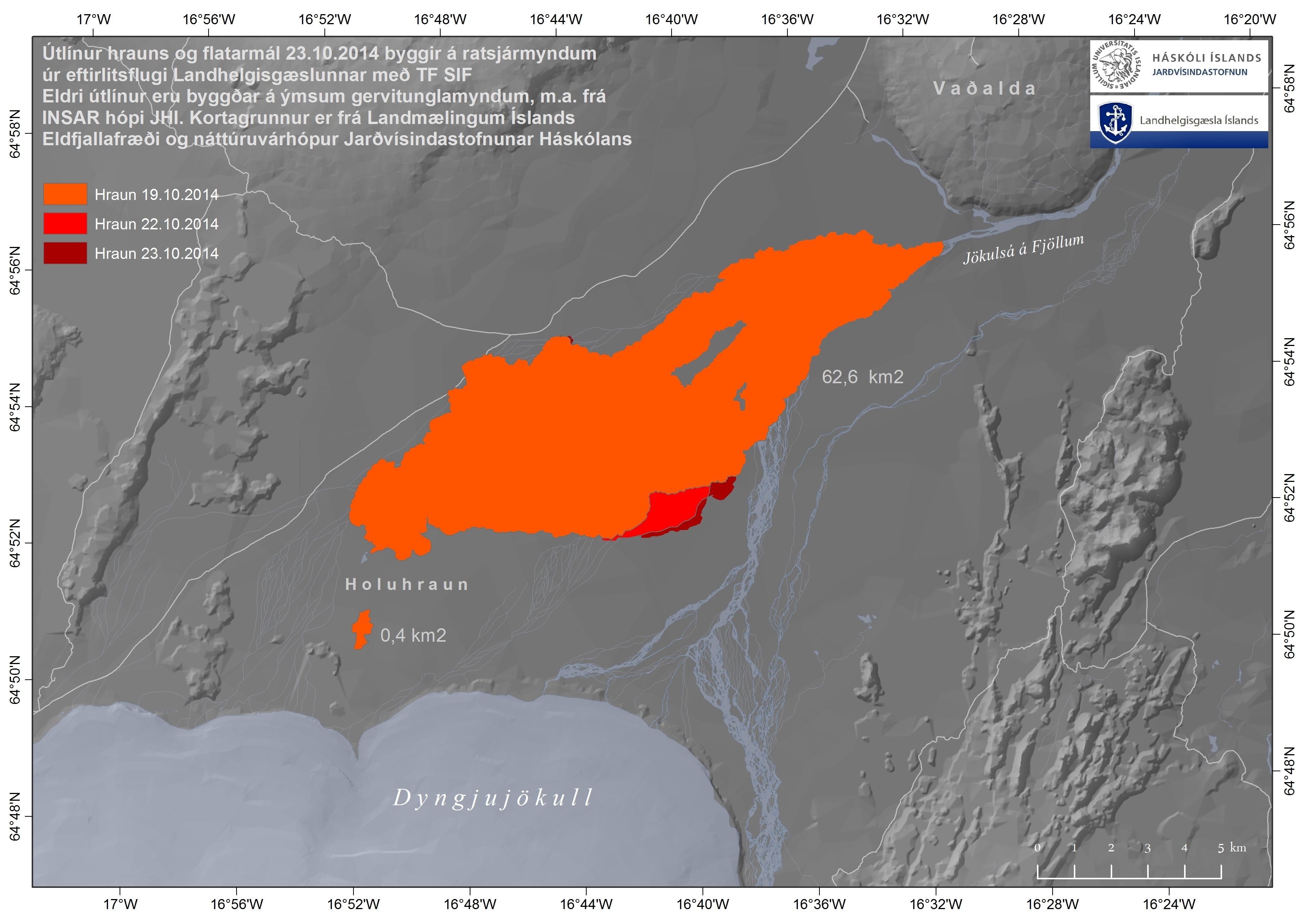
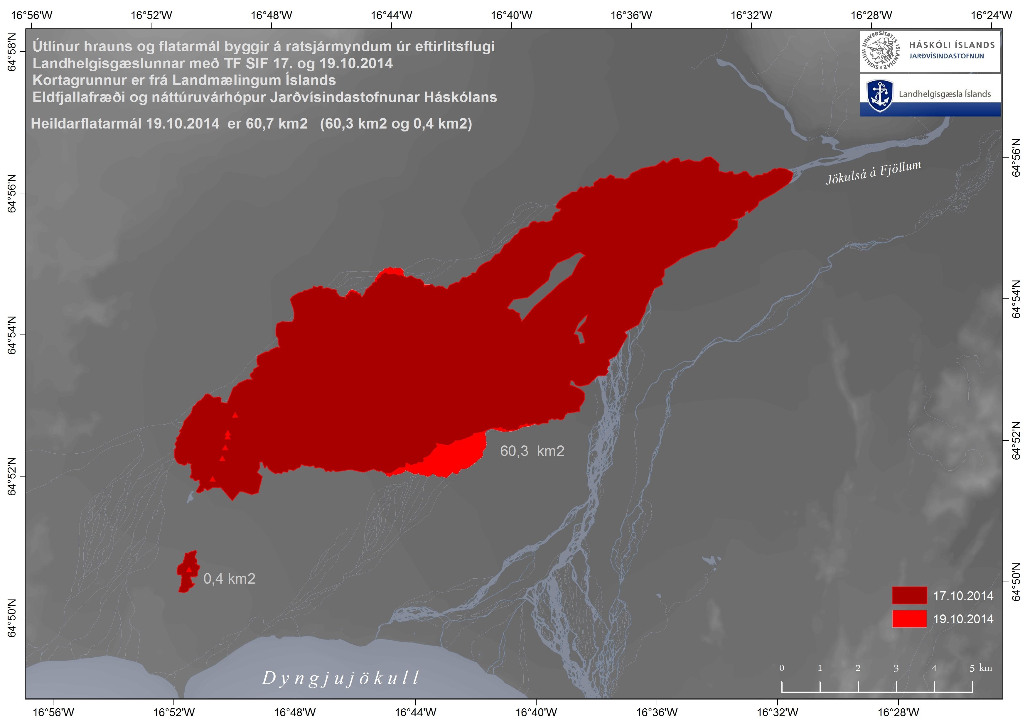
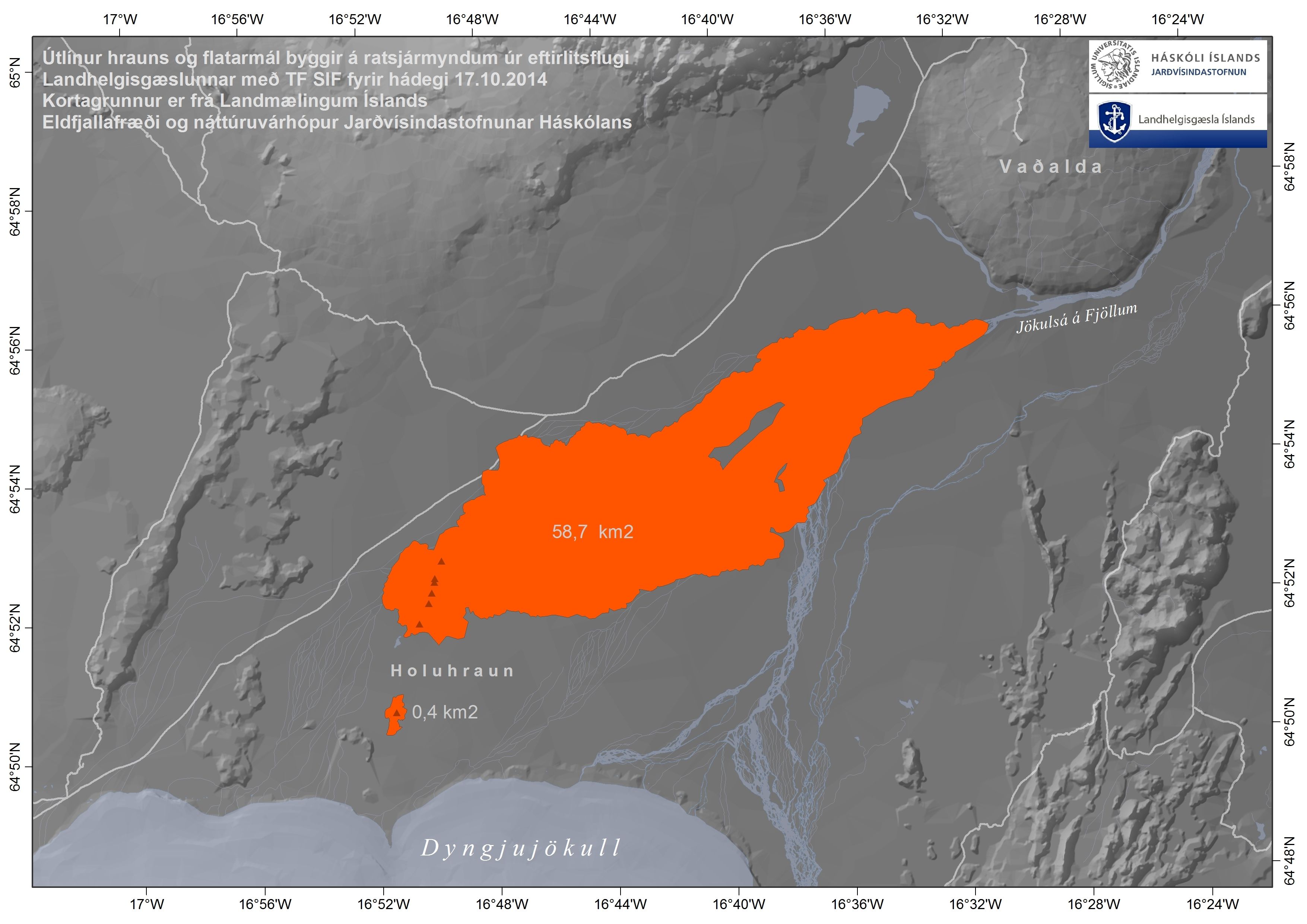
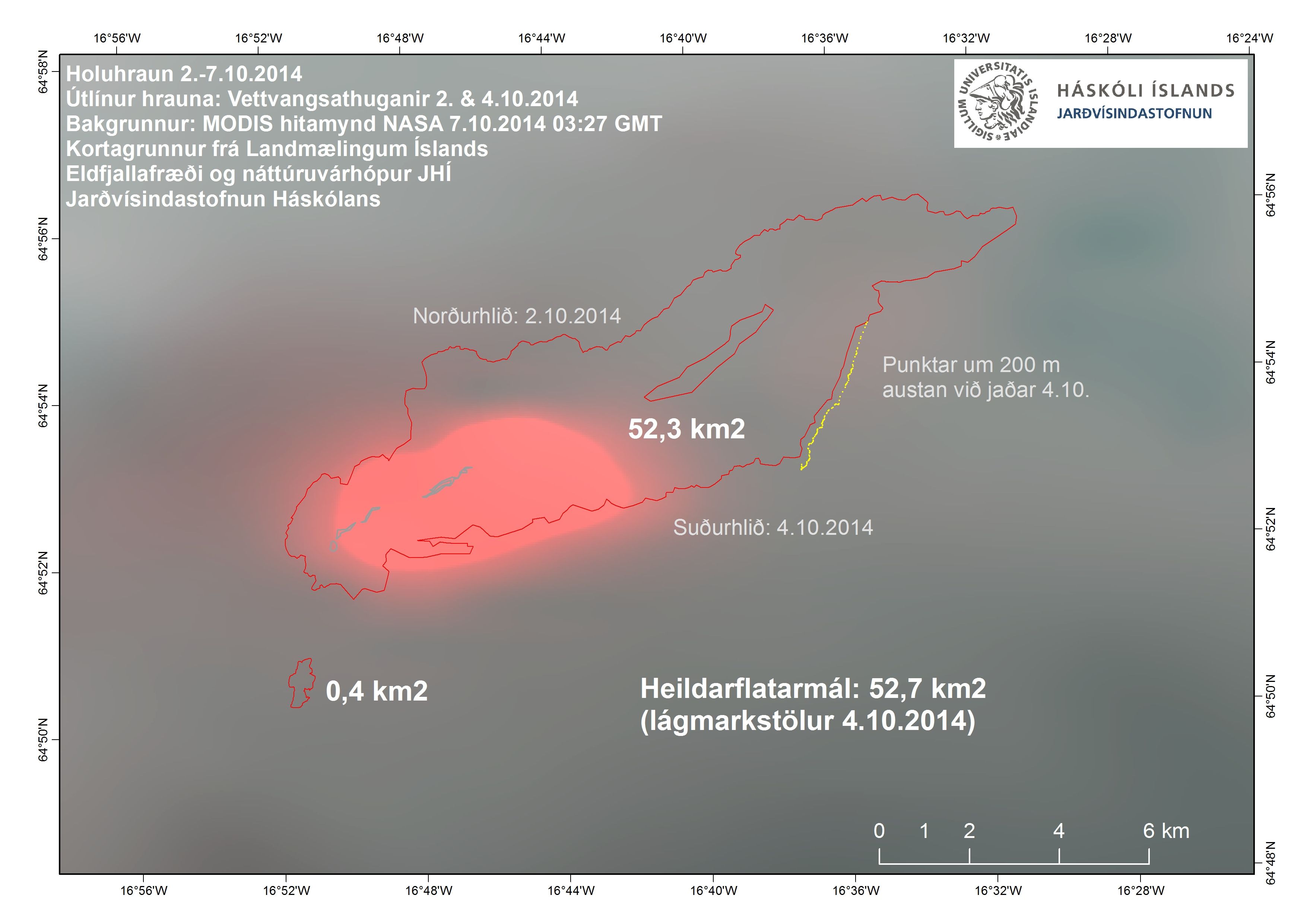
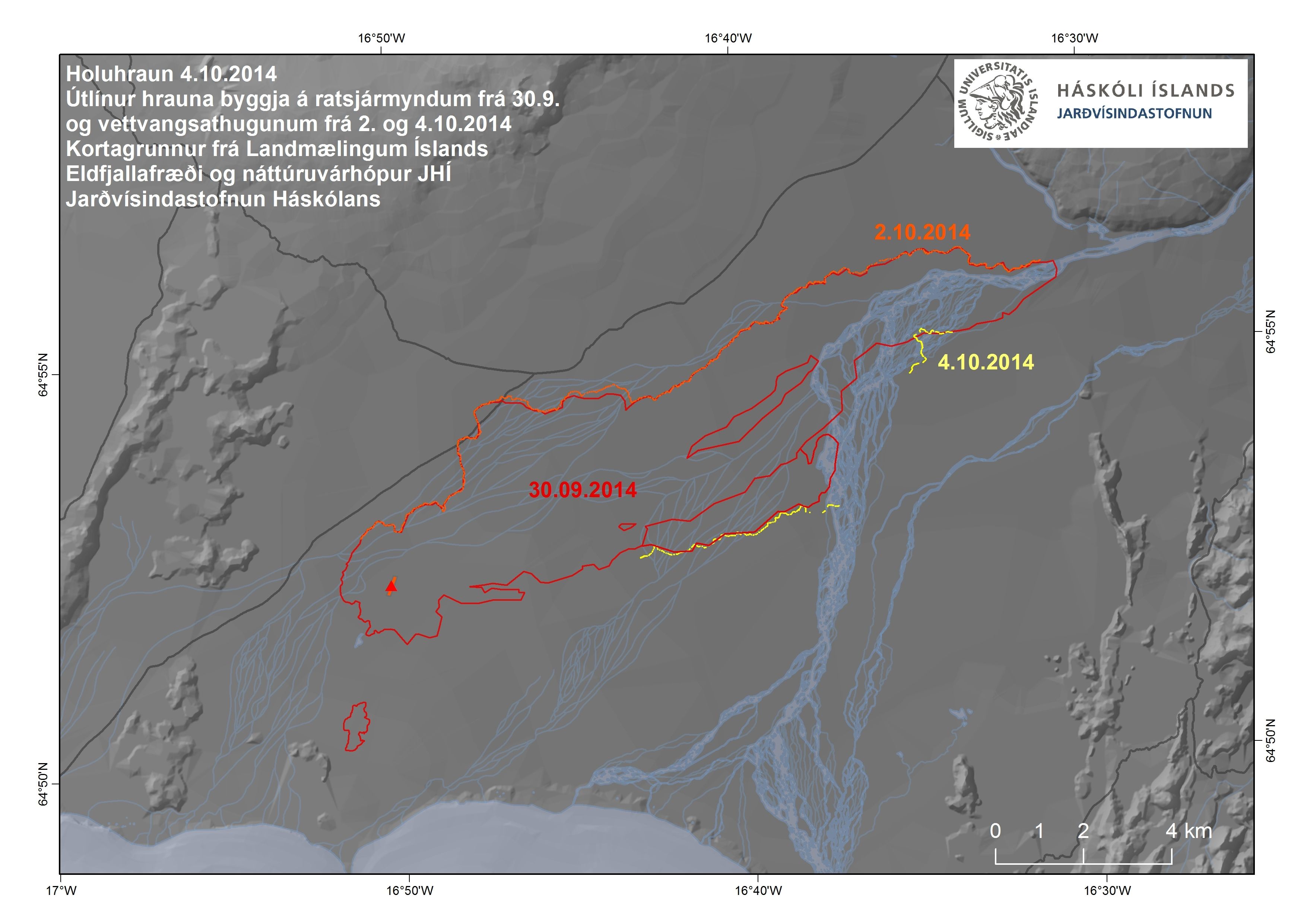
The Institute of Earth Sciences has issued a new map of the lava extent, based on radar images from today's surveillance flight by the Icelandic Coast Guard. The total extent of the lavas is now 60.7 km2 (60.3 km2 + 0.4 km2). A considerable lobe has protruded southwards but also a small one to the north; see enlarged map.
19 October 2014 12:00 - from geoscientist on duty
Seismic activity in Bárðarbunga continues. Largest earthquakes past 26 hours:
18 Oct at 20:17 M5.0
18 Oct at 23:04 M4.7
19 Oct at 03:22 M5.2
19 Oct at 09:47 M4.5
The eruption site was visible on webcams this morning, but currently the area is covered with low clouds and no visibility. There is low activity at the eruption site and in the intrusion. A few small quakes were observed in the Öxarfjörður area, and the general activity in Iceland is very low.
18 October 2014 10:00 - from geoscientist on duty
Activity in the Tungnafellsjökull area has decreased, but is still considerable in Bárðarbunga. An earthquake of magnitude M5.4 occurred at 09:40 UTC this morning in the northern caldera rim of Bárðarbunga. This is one of the largest quakes during the eruption, but no significant changes in caldera subsidence were observed due to it.
Visibility is poor in the eruption area, and webcams have not been useful since yesterday afternoon. Low clouds and precipitation (sleet or snow) currently at the eruption site.
17 October 2014 11:45 - from the Scientific Advisory Board
Notes from the Scientific Advisory Board (pdf 0.4 Mb)


17 October 2014 10:00 - from geoscientist on duty
About 100 earthquakes have been observed in Iceland during the past 24 hours, of which 84 were close to the Bárðarbunga area. Few quakes were located in the intrusion but over 40 in the Tungnafellsjökull area. The overall activity is similar to the day before. No quake observed above M5 but 5 over M4 during the past 24 hours.
16 Oct 16:10 M4.6
16 Oct 21:25 M4.5
17 Oct 01:58 M4.4
17 Oct 07:14 M4.0
17 Oct 08:13 about M4
16 October 2014 10:00 - from geoscientist on duty
During the last 24 hours, about 70 earthquakes have been detected at Bárðarbunga and a dozen in the northern part of the dike. This is somewhat less activity than 24 hours earlier. Two quakes over five in magnitude occurred at the northern caldera rim; an M5.4 at 11:16 yesterday and an M5.0 in the early hours of the morning, at 03:14 today. One earthquake M4.2 occurred later this morning, at 09:25, in a similar location.
Observations of deep thudding sounds were received yesterday while the large earthquake occurred, possibly as a consequence thereof. Scientist went to Askja yesterday but found no signs of a rockfall, which could have caused the noises. Possibly the sounds were from jet aircrafts, passing at the same time.
15 October 2014 11:40 - from the Scientific Advisory Board
Notes from the Scientific Advisory Board (pdf 0.4 Mb)


15 October 2014 10:00 - from geoscientist on duty
As reported yesterday, there is an increase in the number of detected earthquakes in the Bárðarbunga area. Calm weather recently, resulting in better detection of small earthquakes, is hardly enough to explain this increase anymore and probably this increase is real. During the last 24 hours, almost 130 earthquakes have been detected at Bárðabunga and about 30 in the northern part of the dike. No quakes above 5 in magnitude have been detected since 12 October, but five quakes yesterday were between 4.5 and 4.8. The eruption was clearly visible on webcams from midnight until almost 8 o‘clock this morning.
14 October 2014 10:00 - from geoscientist on duty
Seismicity is similar to last days.
Most earthquakes occurred at Bárðarbunga. The last 24 hours over 80 earthquakes have occurred there and more than 50 in the dike. These numbers are higher than in last week but the difference can probably be explained by frequent lows and storm the first days in October (small earthquakes are not so easily detected when it is windy). During the last few days, weather in the area has been calm.
Three earthquakes, between 4 and 5, have occurred in the area:
19:00 yesterday evening, M 4.7
01:10 last night, M 4.7
06:41 this morning, M 4.5
13 October 2014 11:30 - from the Scientific Advisory Board
Notes from the Scientific Advisory Board (pdf 0.4 Mb)
13 October 2014 10:00 - from geoscientist on duty
Earthquakes: Seismicity is continuing in the Bárðarbunga area, most of the earthquakes occurred at the northern rim of the caldera. Many earthquakes were also located in the dike - from the eruption site and ca 10 km under Dyngjujökull.
The largest earthquakes since 10:00 yesterday:
10:07 4,7 (12 Oct.)
21:23 5,2 (12 Oct.)
09:16 4,8
09:26 4,5
Eruption: Webcameras show no significant changes in the eruption and geoscientists on site confirm that. Visibility over the site was good until 07:00 this morning.
12 October 2014 10:00 - from geoscientist on duty
Eruption: Webcameras show no significant changes in the eruption.
Earthquakes: Since 10:00 UTC yesterday (Saturday) two quakes over magnitude 5 occurred in Bárðarbunga. The first one M5.0 at 11:30 yesterday and M5.2 at 08:43 this morning. Both originated in the northern rim of the Bárðarbunga caldera. Additionally, four quakes over magnitude 4 were registered: Yesterday M4.7 at 19:33, M4.1 at 01:36 last night, M4.0 at 03:57 and M4.2 at 06:20. Over 100 quakes have been registered during past 24 hours in the caldera and about 25 in the northern part of the intrusion.
Gas pollution: Northeasterly winds are expected today (Sunday), so the pollution is expected towards south and southwest from the eruption. Polluted area is bounded by Faxaflói in the west and Mýrdalur in the east and is expected to extend north of Hofsjökull. Tomorrow (Monday) wind will be southerly and the pollution will go north.
The Icelandic Met Office provides two-day forecasts on gas dispersion from the eruptive site in Holuhraun. Most reliable are the forecast maps approved by meteorologist on duty. And although still being developed further, an automatic forecast (trial run, see disclaimer) is also available.
11 October 2014 10:00 - from geoscientist on duty
From now on a change is made in these reports from a geoscientist on duty, and they will be published daily at about 10:00 UTC. This may be changed if the eruption changes significantly.
The eruption continues with the same lava flow rate as in past weeks.
Seismicity is similar to previous days:
- There is low activity in the dyke intrusion. Around 20 earthquakes have occurred during the last 24 hours, all within magnitude 1.5 and in the northern part of the intrusion between the eruption site and to the south some kilometers under Dyngjujökull glacier.
- About 80 earthquakes were detected on the caldera rim of Bárðarbunga. The largest earthquakes were at 11:26 and 23:51 yesterday, both of magnitude 4.8. Earthquakes of magnitude 4.7 and 4.5 also occurred and seven between 3.0 and 3.9. Most activity was on the northern caldera rim.
Displacements (no significant changes):
- Minor movements of GPS stations in the area.
- Subsidence of the caldera continuing at similar rate.
Water monitoring: No changes.
Gas forecast (latest forecast 09:32 UTC): Today (Saturday) and tomorrow (Sunday): Northeasterly winds are expected with the possibility of gas pollution south and southwest of the eruption site in an area from Hellisheiði in the west to Hornafjörður in the east.
The Icelandic Met Office provides two-day forecasts on gas dispersion from the eruptive site in Holuhraun. Most reliable are the forecast maps approved by meteorologist on duty. And although still being developed further, an automatic forecast (trial run, see disclaimer) is also available.
10 October 2014 19:00 - from geoscientist on duty
Since midnight, no earthquakes above M5 have been detected in the caldera. The largest occurred during the night (4.7 in size) and half an hour before noon, M4.8. Quite a number of smaller quakes has been detected at the caldera (almost 60 since midnight, the majority at the northern rims). Also in the dike (about 20), from the eruptive site and to about 10 km within the Dyngjujökull margin.
An observation from a surveillance flight with TF-SIF today, revealed great blue mist and gas from the eruptive site to about 3 km height above the crater. From there, it is carried across the South Iceland lowland and across West Iceland as far as could be seen from the aircraft. The pollution seems to be greatest just west of Eyjafjallajökull but is also considerable towards Mýrdalssandur.
10 October 2014 12:00 - from the Scientific Advisory Board
Notes from the Scientific Advisory Board (0.4 Mb)

10 October 2014 07:00 - from geoscientist on duty
Seismic activity at Bárðarbunga is similar as before. Six earthquakes, size around M4, have been located the last 24 hours, five at the northeastern rim of the caldera and one, at 19:13 at the southeastern part of the rim.
13:36 M4.1
19:13 M4.8
21:22 M5.2
01:40 M3.8
02:24 M4.7
06:41 M3.8
The subsidence of the Bárðarbunga caldera continues with similar rate.
The eruption can't be seen on webcams.
9 October 2014 19:00 - from geoscientist on duty
About 25 earthquakes have been observed in the last 12 hours (a little over 40 since midnight), located on Bárðarbunga, the largest M4,1 at 13:36 PM on the northern rim of the caldera. Five small earthquakes were observed in the dike intrusion and about 20 close to Herðubreið.
The eruption can not be seen on the webcams.
9 October 2014 - a high definition image of the lava

9 October 2014 07:00 - from geoscientist on duty
Seismic activity at Bárðarbunga is similar as before. Two earthquakes over M4 occurred the last 12 hours at the northern rim of the caldera:
18:49 M4.6 (8 Oct.)
04:37 ca. M5
The subsidence of the Bárðarbunga caldera continues with similar rate.
Visibility is not good in the area and the eruption couldn't be seen in webcams last night.
8 October 2014 19:00 - from geoscientist on duty
Since 07 AM, a little over 30 earthquakes have been located at Bárðarbunga (a little under 50 since midnight). The largest were at the northeastern rim, at 15:17 M3.9 and at 15:24 M5.2. Two small earthquakes were located in the dike intrusion, one under Dyngjujökull and the other in front of the glacier margin. Visibility to the eruptive sight is good (web cameras) and the strength of the eruption seems to be of the same degree as recently.
8 October 2014 11:00 - from the Scientific Advisory Board
Notes from the Scientific Advisory Board (pdf 0.4 Mb)
8 October 2014 08:45 - number of earthquakes since the onset

A new table with the approximate number of events, and the total number of events over M3 in size, (pdf 30 Kb) since the onset of these seismic events in northwestern Vatnajökull 16 August 2014. In the whole country, at least 23,000 - 25,000 events have been detected automatically during this period, the majority in NW Vatnajökull, while in ordinary circumstances about 10,000 - 15,000 automatic events occurs per year in Iceland. For comparison, an older table is available.
8 October 2014 07:00 - from geoscientist on duty
Ten earthquakes have occurred in the northwestern part of Vatnajökull since midnight and almost 30 since 19:00 yesterday evening, most of them in Bárðarbunga. The largest earthquake since 19:00 yesterday was M3.9 at 03:37. It is cloudy in the area and the eruption has not been seen in webcams since 01:00. Then it looked similar as the last days.
7 October 2014 19:00 - from geoscientist on duty
Seismic activity around Bárðarbunga, and volcanic activity at the eruption site at Holuhraun, has been comparable to recent days.
Seismicity is low in the dyke intrusion; since the last report at 07:00 this morning around 15 earthquakes have been detected in the northern part of the dyke (less than 20 since midnight) and the strongest one was magnitude 1.1.
About 25 earthquakes have been detected around the Bárðarbunga caldera rim during the last 12 hours (40 since midnight), the strongest event there was magnitude 5.5 at 10:22 on the southeastern rim (and since midnight a 5.0 earthquake on the northwestern rim at 03:51 must be included). Additionally, eight more earthquakes exceeded magnitude 3 since 07:00 (11 since midnight).
Scientists in the field confirmed at 18:40 that the eruption is continuing at similar rates as during the last days; there is no visibility of the eruption site on the webcams.
7 October 2104 - the lava outlines
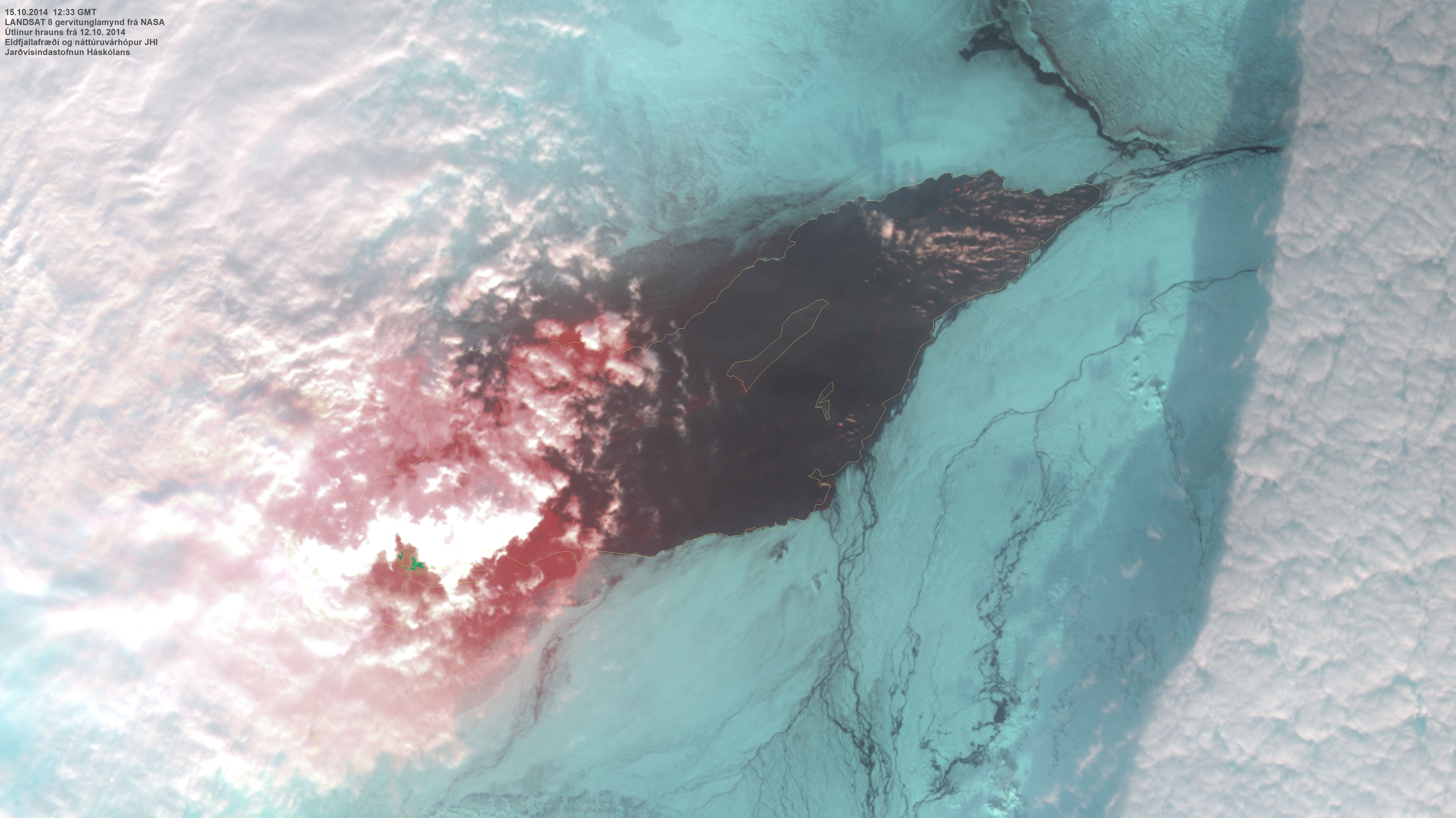
A satellite image of the outlines of the lava, 7 Oct. 2014, was received from Fjarkönnun ehf.
7 October 2014 11:00 - on the gas dispersion
The Icelandic Met Office provides two-day forecasts on gas dispersion from the eruptive site in Holuhraun. Most reliable are the forecast maps approved by meteorologist on duty. And although still being developed further, an automatic forecast (trial run, see disclaimer) is also available.
For advice on SO2, please check the Environment Agency of Iceland and the Directorate of Health.

7 October 2014 07:00 - from geoscientist on duty
Since 19:00 yesterday almost 30 earthquakes have occurred in Bárðarbunga, thereof more than 15 since midnight. Three were larger than M4:
00:33 M4.5
03:52 M5.0
06:07 M4.0
At 22:00 last night one earthquake, M3.8 occurred.
Very few earthquakes were located in the dike. The largest one, M2.7, occurred at 19:29 last night. Strong wind was in the area and that can have increased the number of small events. Later in the night the wind has been going down.
The eruption can't be seen through webcams. Just for a short while in the night it could be seen and looked similar as last days.

6 October 2014 19:00 - from geoscientist on duty
Seismic activity in the dyke intrusion was low today, see today's map (and compare to a 24 hours map a week ago). Since 07:00 this morning, only about 5 earthquakes have been detected there (less than 10 since midnight), all below magnitude 2. Storm conditions around Vatnajökull might affect the detection of the smallest earthquakes.
Around 20 earthquakes have been detected around the Bárðarbunga caldera rim since the last report at 07:00 (ca. 30 since midnight). The strongest event was magnitude 5.1 at 11:04 on the northern caldera rim. Of these, seven events exceeded magnitude 3 (ten since midnight).
The visibility of the eruption at Holuhraun on the webcams was limited today. Scientists in the field, and the ranger in Dreki, have confirmed that it is continuing at comparable levels as during recent days.
6 October 2014 11:30 - from the Scientific Advisory Board
Notes from the meeting of the Scientific Advisory Board (pdf 0.4 Mb).
6 October 2014 07:00 - from geoscientist on duty
Since 19:00 UTC yesterday almost 20 earthquakes have been located at Bárðarbunga (ca 10 since midnight). Little activity has been in the dike. Some small earthquakes have been located southwest of Kópasker.
The largest earthquakes:
22:50 M4,3 (5. Oct.)
00:09 M3,7
03:00 M3,8
05:32 M4,2
Volcanic activity in Holuhraun appears to be stable according to webcam observations.
5 October 2014 19:00 - from geoscientist on duty
A total of 115 earthquakes have been located today. Additionally, some data has not been processed and the total number will increase. Of the located quakes 21 are larger than magnitude 3. The largest quake of magnitude 5.0 occurred at 16:59; another of magnitude 4.8 at 03:55; and magnitude 4.7 at 11:14.
Most of the seismic activity is in the Bárðarbunga caldera rim, and some activity at the northern end og the dike intrusion and also close to Herðubreiðartögl.
Furthermore, 20 quakes were located offshore several kilometers southwest from Kópasker. The largest of these of magnitude 3.4 occurred at 09:34.
The eruption is currently not visible on webcams due to clouds.

5 October 2014 11:00 - a joint overview from IMO and IES
Volcanic activity: The eruption continues at similar intensity as in recent days. According to scientists in the field (Ármann Höskuldsson et al.), a new lava front at the southern edge of the main lava flow has been advancing eastwards in recent days.
Seismic activity: Similar to recent days.
- Low activity in the dyke intrusion. About 20 detected earthquakes during the past 24 hours, all in the northern part of the intrusion between the eruption site and to the south a few kilometers into Dyngjujökull glacier. No event exceeded magnitude 1.5.
- About 70 earthquakes were detected in the caldera rim of Bárðarbunga, largest event was magnitude 5.0 yesterday at 12:05. Four events were between magnitude 4.0 and 4.9, 17 events between 3.0 and 3.9. Most activity was in the northern and southwestern caldera rim.
Displacement: No significant changes.
- Minor movements on GPS stations in the area.
- Subsidence of the caldera continuing at similar rate.
Water monitoring: No changes.
Gas forecast (lates forecast at 11:08):
Today (Sunday) around noon, gas pollution from the eruption is expected to travel northwest. In the afternoon, the wind gradually turns, and tonight the pollution will be heading towards west. Therefore, it is possible that gas pollution will be felt in the northwestern quarter of the country today, from Eyjafjörður to Breiðafjörður. Tomorrow (Monday) the gas pollution will travel towards west and westsouthwest. Pollution is possible in the area between Snæfellsnes and Reykjanes. Therefore, it is possible that the pollution may reach Reykjavík for some time tomorrow.
See forecast maps approved by meteorologist on duty.
See also an automatic forecast (trial runs, disclaimer).
5 October 2014 07:00 - from geoscientist on duty
Seismic activity at Bárðarbunga remains at stable levels. Since 19:00 UTC yesterday (4 Oct) about 30 earthquakes have been detected in the caldera rim (about 20 since midnight), of which 12 exceeded magnitude 3 (11 since midnight). Strongest events were M4.1 at 02:40 and M4.8 at 03:54 in the northern caldera rim.
The observed earthquake frequency has been relatively low in the dike intrusion, about 10 small events during the past 12 hours (about 5 since midnight), all below magnitude 2.
No obvious changes are seen in the volcanic activity at the eruption site in Holuhraun.
4 October 2014 19:00 - from geoscientist on duty
Eight earthquakes greater than magnitude 3 have been located since 07:00 UTC this morning. The largest were in the northern caldera rim of Bárðarbunga, but two quakes were located in the southern rim. The largest quake, of magnitude 5, was observed at 12:05. At 14:34 a quake of magnitude 4.1 was observed, and another of magnitude 4.9 at 18:55.
The earthquake activity is dispersed along the caldera rim and in the northern end of the dike towards the eruption site. Additionally, a few small quakes have been located close to Herðubreið and Herðubreiðartögl.
Currently, the eruption is not visible on the webcams, but earlier today webcams indicated no significant changes in the eruption.


4 October 2014 11:00 - a joint overview from IMO and IES
Volcanic activity: The eruption continues at similar intensity as in recent days. Steady lava production.
Seismic activity (similar to recent days):
- Comparably low activity in the dyke intrusion. Around 20 detected earthquakes during the last 24 hours, all below magnitude 2 and in the northern part of the intrusion between the eruption site and to the south some kilometers into Dyngjujökull glacier.
- Around 50 detected earthquakes on the caldera rim of Bárðarbunga, largest event magnitude 5.0 yesterday at 12:42, all together 9 events exceeded magnitude 3 since yesterday, 03 October 11:00.
Displacement (no significant changes):
- Minor movements on GPS stations in the area.
- Subsidence of the caldera continuing at similar rate.
Water monitoring: No changes.
Gas forecast:
At the moment the gas plume is drifting north towards Öxarfjörður, Skjálfandi and later Eyjafjörður. Based on the latest forecast (09:41 UTC), wind will change to south-easterly directions throughout the day and gas pollution can be expected in the northwest and west as far as Breiðarfjörður later in the evening. Wind is predicted to change back to southerly directions overnight, gas pollution can then be expected again in the northern parts of the country.
See forecast maps approved by meteorologist on duty.
See also an automatic forecast (trial runs, disclaimer).
4 October 2014 07:00 - from geoscientist on duty
Seismic activity around Bárðarbunga within the last 12 hours has been comparable to recent days. Around 40 earthquakes have been detected around the Bárðarbunga caldera rim since 19:00 last night (of these ~25 since midnight) and around 15 in the dyke intrusion since 19:00 (~10 since midnight). Earthquakes in the dyke were all smaller than magnitude 2.
The strongest events on the caldera rim were:
M4.2 22:02 (3.10.)
M3.8 00:44 (4.10.)
M4.6 02:24
M4.6 05:57
M4.2 06:03
Volcanic activity appears to be stable according to webcam observations. No obvious changes observed.
3 October 2014 19:00 - from geoscientist on duty
The largest earthquake at Bárðarbunga since 07 AM was size 5.0 at 12:42, originating at the northern caldera rim. Another earthquake, size 3.8, occurred at 13:17 and yet another 4,7 at the northern caldera rim, just now at 18:49. Other earthquakes were less than 3 in size. Since 07 AM, all in all 29 earthquakes were detected at the caldera, nearly all at the northern rim.
At the northern end of the intrusive dike, seven earthquakes were detected which were all below 1.5 in size. At Herðubreið there were six earthquakes, all less than 2 in size.
3 October 2014 - gas dispersion trial forecast
A trial forecast is made for gas dispersion, based on Calpuff modelling. For the time being, it is only available on our Icelandic web-site. Please read carefully the disclaimer (in English) below the map.
3 October 2014 11:40 - from the Scientific Advisory Board
Notes from the meeting of the Scientific Advisory Board (pdf 0.4 Mb).
3 October 2014 07:00 - from geoscientist on duty
Seismic activity in the northwestern part of Vatnajökull and north of the glacier continues and ca 50 earthquakes have been located since 19:00 yesterday evening. Most of the earthquakes have occurred in Bárðarbunga but some in the northern part of the dike.
Earthquakes, larger than M3 in chronological order (all in the northern part of Bárðarbunga caldera):
20:08:22: M3,1
20:08:32: M4,5
20:40:43: M3,3
00:20:03: M3,9
01:41:34: M4,8
04:13:22: M3,7
04:45:19: M4,3
One earthquake, M2.4, occurred at 21:57 yesterday evening 10.4 km soutwest of Kópasker.
2 October 2014 19:00 - from geoscientist on duty
Since midnight six earthquakes over 4 in size have been detected at Bárðarbunga but not any quakes between 3 and 4 in size. The largest were 4.8 at 00:36 and at 13:27; the first at the northern rim and the second at the southern rim.
Since midnight just over 40 earthquakes have been detected at the Bárðarbunga caldera. Only eight quakes have been detected in the northern part of the dike, all near or under 1 in size. A few quakes occurred at Herðubreið and Töglin.
According to web cameras, the eruption in Holuhraun is of similar intensity as recently.
Seismic activity has been prevalent in Öxarfjörður (Axarfjörður) bay off the northern coast of Iceland, about 5-10 km southwest of the village Kópasker. The largest was 3.3 at 09:03 this morning.

2 October 2014 07:00 - from geoscientist on duty
Since 19:00 yesterday automatically detected events are around 20. Biggest measured was at 00:37, magnitude 4.8. Second biggest was magnitude 4.6 at 06:40 this morning. Both of them are in the northern part of the Bárðarbunga caldera. Most of the smaller events are magnitude 1-2 and located at the northern part of the dike intrusion as well as in Bárðarbunga.
1 October 2014 19:00 from geoscientist on duty
Seismic activity at Bárðarbunga and in the dyke intrusion during the last 12 hours has been similar to recent days. Stormy conditions causing noise on seismometers can still influence the detection of small earthquakes.
Since the last report at 07:00 this morning, around 10 earthquakes have been detected in the intrusion, all of them smaller than magnitude 1.5. Around 30 earthquakes were detected around the Bárðarbunga caldera, the strongest was magnitude 4.8 at 17:59 on the northern caldera rim. No earthquake larger than magnitude 5 has occurred since Monday 13:42.
Since midnight: Around 15 in the dyke, all smaller than M1.5. Around 40 around the caldera, strongest M4.6 at 02:44 and M4.8 at 17:59.
Volcanic activity at the eruption site in Holuhraun continues at same levels as in recent days.
1 October 2014 - the number of earthquakes since the onset

Here is a new table with the approximate number of events, and the total number of events over M3 in size, (pdf 30 Kb) since the onset of these seismic events in northwestern Vatnajökull 16 August 2014. In the whole country, at least 22,000 - 24,000 events have been detected automatically during this period, the majority in NW Vatnajökull, while in ordinary circumstances only about 10,000 - 15,000 automatic events occurs per year in Iceland. For comparison, an older table is available.
1 October 2014 11:40 - from the Scientific Advisory Board
Notes from the meeting of the Scientific Advisory Board(pdf 0.4 Mb).
1 October 2014 07:00 - from geoscientist on duty
The largest earthquake at Bárðarbunga since 19:00 yesterday occurred at 19:24 and was M4.8. The second largest occurred at 02:44 and was M4.6. Five earthquakes larger than M3.0 have been located since 19:00 yesterday, all at the northern rim of the Bárðarbunga caldera. The largest earthquake in the northern part of the dyke since 19:00 yesterday occurred at 21:02 and was M2.8.
Since midnight 9 earthquakes have been located in the Bárðarbunga caldera and 3 in the northern part of the dyke. Two earthquakes have occurred at Askja and Herðubreið.
1 - 30 September 2014
Observations from the month of September are found in another comparable article.


