
Bárðarbunga 2014 - November events
Seismic and volcanic events 1-30 November
The November observations (pdf 0.89 Mb) of the Bárðarbunga seismic and volcanic events are given here with daily notes, factsheets and additional material. Information, day by day, is given in reversed order. In combination, the monthly articles give an overview of events: August, September, October, November, December, January, February, March-April-May and the overview article (list of links).
Calendar
Below is a calendar with a short-cut to each day of this month's events:
Nov: 1-2-3-4-5-6-7-8-9-10-11-12-13-14-15-16-17-18-19-20-21-22-23-24-25-26-27-28-29-30-
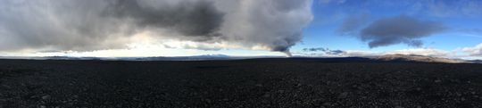 Panoramic view towards the eruptive site in Holuhraun 3rd September 2014. Photo: Richard Yeo.
Updated information
30 November 2014 13:00 - from geoscientist on duty
Since 12:00 yesterday, 29 November, around 90 earthquakes have been detected within Bárðarbunga. Most of the recorded seismicity occurred on the northern side of the volcano's caldera. Similar to yesterday, hardly any earthquake activity was detected along the dyke intrusion.
Since yesterday's report, two earthquakes of magnitude 4.5 have been recorded. The first one at 04:16 today, followed by a second magnitude 4.5 earthquake at 08:11. Both earthquakes were sourced from the caldera of Bárðarbunga. An additional twenty earthquakes equal to or greater than magnitude 3 have been registered.
In comparison to the last 48 hours, the level of earthquake activity from the caldera is higher. Similar changes in earthquake rate have been observed several times since the unrest began at Bárðarbunga in mid August.
At the time of writing, there is a clear view of the eruption site from the Míla camera on Vaðalda. The last 24 hours of images show no obvious changes in the size or intensity of the eruption.
29 November 2014 - how the subsidence is monitored
Until recently, point measurements of the subsidence of the Bárðarbunga caldera were available in near real time as the IMO mounted a GPS station there, 12 September. This station has now subsided so much that it is out of sight of the neccessary relay station in Kverkfjöll and therefore no signal is received.
The subsidence of the Bárðarbunga caldera has also been observed by doing flights along a certain north-south section repeatedly. For convenience, the results are presented schematically, see below. The lower graph has a sixfold exaggeration of the vertical axis and on the upper one the difference in hight is multiplied by a factor of 120. The intention is not to make an image which resembles the volcano but to distinguish clearly and graphically between the results derived after each surveillance flight. Eight flight measurements are shown, from 5 September to 26 November 2014. The Institute of Earth Sciences makes these measurements and interprets the results. A comparison of the black line and the light blue one reveals that the subsidence has not only continued since September but also broadened, affecting a larger area.

29 November 2014 12:30 - from geoscientist on duty
Since 10:00 AM yesterday, 28 November, around 40 earthquakes have been detected within Bárðarbunga. Most of the recorded seismicity occurred on the northern side of the volcano's caldera. Hardly any earthquake activity was detected along the dyke intrusion.
The largest detected earthquake since yesterday's report registered magnitude 4.5. This earthquake occurred at 01:51 today on the northern side of the caldera, see earthquake maps. Of the 40 caldera earthquakes since 10:00 AM yesterday, five exceeded magnitude 4.
Overall, seismicity levels are slightly lower in recent days. Similar changes in earthquake rate have been observed several times since eruptive activity began on Holuhraun.
At the time of writing, there is a clear view of the eruption site from the Míla camera on Vaðalda. The last 24 hours of images show no obvious changes in the size or intensity of the eruption.
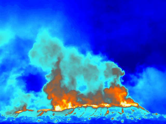
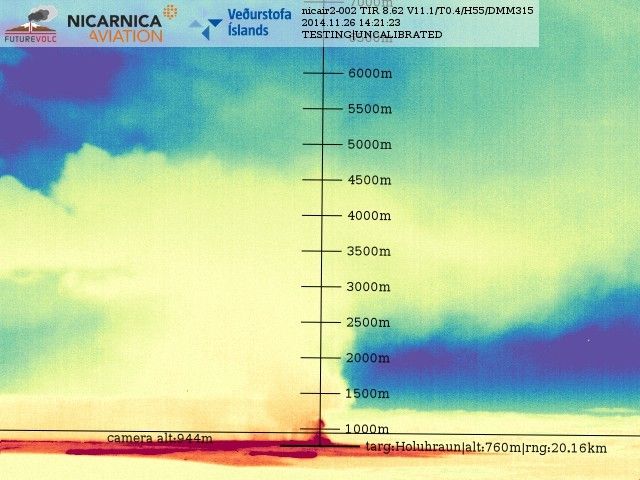
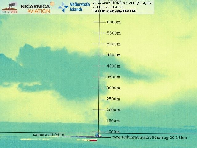
28 November 2014 - thermal images for SO2 assessment
Infrared cameras were developed by Nicarnica Aviation for the Futurevolc project. They are now undergoing further operational testing at Holuhraun, producing thermal images. One was placed at Vaðalda 20 Nov 2014, at a 20 km distance from the eruptive site.

Photo: Richard Yeo.
Thermal imaging is especially important in allowing scientists to monitor the eruptive plumes during nighttime. Although further software and mechanical improvements are still being developed by the camera manufacturer, the data from these instruments is already proving useful for the detection of SO2 emission from the eruption. A graded scale on the images helps in estimating the plume height and the SO2 release height.
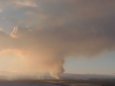
The following images give a comparison between the SO2 sensitive thermal channel at 8.6 micrometer wavelength and a general channel at 10.9 micrometer wavelength. Any significant difference between these two images suggests the presence of SO2 gas in the air, and is presented on the third image by the colours orange or bright red. An ordinary webcam photo from the same moment is presented as well. These images were made at 26 Nov at 14:21.


28 November 2014 11:30 - from the Scientific Advisory Board
Scientists flew over Bárðarbunga on Wednesday, 26 November. According to data acquired in the flight, the total subsidence of the caldera is 50 meters and the volume is 1.4 cubic kilometers. No signal is now received from the station in the caldera and the most likely explanation is that has subsided below the caldera rim and is therefore out of sight of the relay station in Kverkfjöll.
Notes from the Scientific Advisory Board (pdf 0.4 Mb)
28 November 2014 11:00 - from geoscientist on duty
In the last forty-eight hours, 170 earthquakes were detected in Bárðarbunga. The largest earthquake was this morning at 06:14, magnitude 5.1. Nearly 20 earthquakes were detected above magnitude 3. About 20 earthquakes were detected in the dyke and around the eruption site.
27 November 2014 10:00 - from geoscientist on duty
Five earthquakes over magnitude 4 have been registered during the past 24 hours in the caldera rim of Bárðarbunga. The largest was 4.8 at 13:14 yesterday. Almost ten had magnitudes between 3 and 4. Most of the quakes originated in the northern caldera rim. Almost 90 quakes were registered in Bárðarbunga past 24 hours, similar to the day before. Eleven quakes were registered in the intrusion during the past 24 hours, the largest had magnitude about 1.5.

26 November 2014 14:00 - from the Scientific Advisory Board
Notes from the Scientific Advisory Board (pdf 0.4 Mb)

26 November 2014 10:00 - from geoscientist on duty
The largest earthquake since 10:00 yesterday morning, M4.4, occurred 23:26. Another earthquake, M4.2, occurred 14:11 yesterday. Since midnight: A M4.1 earthquake occurred at 03:36 and M4.0 at 04:59. An earthquake, M3.9 was measured at 06:25 this morning. All these earthquakes were located at the northern rim of the Bárðarbunga caldera except the one that was measured at 14:11, it was located at the southeastern part of the rim.
The last 24 hours almost 90 earthquakes have been detected at Bárðarbunga, which is a little more than the 24 hours before. Around 10 earthquakes have been detected in the northern part of the dyke intrusion, all less than M1.0.
Visibility to the eruption is good through webcams.
25 November 2014 10:00 - from geoscientist on duty
Since kl. 10:00 yesterday, 24 November, around 70 earthquakes have been detected within Bárðarbunga. Similar to yesterday, most of the seismicity is occurring on the northern side of the volcano's caldera. Of the 70 detected earthquakes, at least 11 are sourced from the northern part of the dyke intrusion under Dyngjujökull.
The largest detected earthquake since yesterday's report was around magnitude 3.8. At least eight other earthquakes exceeded three in magnitude.
Overall, the level of earthquake activity is lower than in recent days. This trend has been observed several times since the Holuhraun eruption began.
Please note that the GPS station on Bárðarbunga is off-line at the moment due to a communication problem.
From web-camera views of Holuhraun, the eruption continues unabated.
24 November 2014 12:00 - from the Scientific Advisory Board
Notes from the Scientific Advisory Board (pdf 0.4 Mb)
24 November 2014 10:00 - from geoscientist on duty
Since around midday yesterday, 23 November, around 50 earthquakes have been detected within Bárðarbunga. Most of the recorded seismicity occurred on the northern side of the volcano's caldera. At least 25 earthquakes were detected on the dyke intrusion; the largest of which was magnitude 1 in size.
The largest detected earthquake since yesterday's report registered magnitude 5.4. This earthquake occurred at 09:03 today on the northern side of the caldera and it was felt in Akureyri.
Of the 50 caldera earthquakes since Sunday, seven were larger than magnitude 4 and 12 larger than magnitude 3.
Seismicity in the Bárðarbunga caldera was comparatively low yesterday and last night following a magnitude 5.1 on Sunday morning. In contrast, seismicity in the dyke intrusion increased slightly in the hours following the magntiude 5.1 earthquake. This trend has been observed several times since the Holuhraun eruption began.
At the time of writing, there is a clear view of the eruption site from the Míla camera on Vaðalda. The eruption seems unchanged in size and intensity since the weekend.
23 November 2014 12:00 - from geoscientist on duty
The situation remains unchanged, although a slight decrease in the number of larger earthquakes has been observed in recent weeks.
A M5.1 earthquake occurred on the southern caldera rim of Bárðarbunga at 09:22 this morning. This was the first M>5 event since last Sunday. Additionally, 14 events exceeded M4 and around 20 were in the range between M3.0 and M3.9. Activity was relatively high throughout last night and dropped considerably following the M5.1 this morning. Similar patterns of increased activity before and decreased activity after M>5 earthquakes have been frequent in the last weeks at Bárðarbunga.
Activity in the dyke intrusion was rather low, but has slightly increased following the M5.1 earthquake this morning. About 15 events have been detected, all below M1.0. A slight increase of seismicity in the dyke during the first hours after M>5 earthquakes at the caldera rim has also been observed in several previous cases since the onset of the activity.
No obvious changes in the volcanic activity at the eruption site in Holuhraun, based on camera observation.
22 November 2014 12:00 - from geoscientist on duty
Seismic activity around Bárðarbunga and in the dyke intrusion continues with comparable intensity as during recent days, seismicity in the dyke is slightly variable. Volcanic activity at the eruption site in Holuhraun remains unchanged.
The two strongest earthquakes at Bárðarbunga were M4.5 yesterday at 12:15 and 22:21, both on the northern caldera rim. Ten additional events were larger than M4.0 and 32 between M3.0 and M3.9. All in all about 120 events have been detected around the caldera.
The strongest event in the dyke intrusion was M1.6 at 10:03 this morning. About 25 events have been detected in the intrusion since the last report. Activity has slightly decreased again after a small peak was measured during the last two days. Events were all in the northern part of the dyke again since yesterday morning.
Minor seismic activity was measured around Herðurbreið and on the Loki ridge between Hamarinn and Grímsvötn.
The fissure eruption in Holuhraun has been well visible on cameras throughout the last days and nights, no obvious changes in volcanic activity have been observed or reported by scientists in the field.
21 November 2014 12:00 - from the Scientific Advisory Board
Notes from the Scientific Advisory Board (pdf 0.4 Mb)

21 November 2014 10:00 - from geoscientist on duty
Slight changes were observed in the seismic activity around the Bárðarbunga area and in the dyke intrusion, volcanic activity at the eruption site in Holuhraun remains unchanged.
The strongest earthquake at Bárðarbunga since the last report yesterday was M4.5 this morning at 07:41 on the northern caldera rim, six additional events were larger than M4.0 and 15 in the range of M3.0-3.9. All in all about 80 events have been detected around the caldera. By now, the last M>5 earthquake occurred more than 5 days ago (Sunday 01:37), which is the longest break between M>5 events since the onset of the crisis. A slight decrease of earthquakes stronger then M5 has in general been observed during recent weeks (see civil defense factsheet from Friday 14 Nov.). However, earthquake activity around the Bárðarbunga caldera remains strong and small changes should not be overinterpreted.
The strongest earthquake in the dyke intrusion was M1.7 yesterday at 17:43 under Dyngjujökull. About 30 events have been detected in the intrusion during the last 24 hours. Most events are still located in the northern part of the dyke intrusion, between the eruption site in Holuhraun and the northern part of Dynjujökull. However, during the past days several events have been located further south around the area where the dyke was halting before bending north around 23. August. This area has been rather inactive in recent weeks.
The fissure eruption in Holuhraun continues with similar intensity (as far as it can be evaluated from camera observation throughout the past days).
20 November 2014 - equipment mounted
A field excursion to Urriðaháls was made to mount a DOAS instrument for measuring SO2. This instrumentation is part of the FutureVolc project.
20 November 2014 - spectacular video
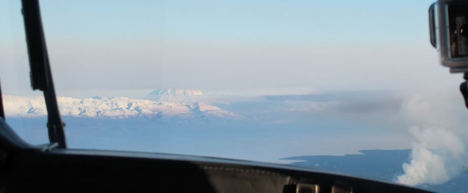
On the website of RÚV, the Icelandic National Broadcasting Service, there is a spectacular video from a flight 17 November 2014 over the eruptive site and the affected area. The visibility is good and all aspects of this magnificent event can be seen.
20 November 2014 10:00 - from geoscientist on duty
Seismic activity around Bárðarbunga and in the dyke intrusion continue with similar intensity as in previous days, volcanic activity at the eruption site in Holuhraun remains unchanged.
The strongest earthquake at Bárðarbunga was M4.6 last night at 00:26 on the northern caldera rim, eight additional events were larger than M4.0 and 24 in between M3.0 and M3.9. All in all around 90 events have been detected around the caldera. The strongest events in the dyke intrusion were M1.9 at 01:03 and M1.8 at 08:46 this morning under Dyngjujökull. Around 25 events have been detected in the intrusion during the last 24 hours.
Minor activity was measured around Herðurbreið, Askja and Tungnafellsjökull, as well as on the Loki ridge between Hamarinn and Grímsvötn.
The fissure eruption in Holuhraun has been well visible on cameras throughout the last days and nights, no obvious changes in volcanic activity have been observed or reported by scientists in the field.
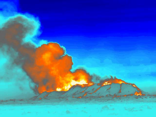
The upper image is taken recently, 18 November 2014 at 16:00. Now, thermal convection is greatest from the northern part, Heimasæta, and the temperature is somewhere in the range 1147-1188°C.
The lower image was taken 23 October 2014. Then, craters Baugur and Heimasæta were both active. Institute of Earth Sciences, information from the field group.
19 November 2014 11:00 - from the Scientific Advisory Board
The volcanic eruption in Holuhraun continues with similar intensity as it has for the last two weeks. Lava continues to flow out of the lava lake in the crater to east-southeast. Notes from the Scientific Advisory Board (pdf 0.4 Mb)
19 November 2014 10:00 - from geoscientist on duty
No significant changes were observed during the last 24 hours in seismic activity at Bárðarbunga and in the dyke intrusion, as well as in the volcanic activity at the eruption site in Holuhraun.
The strongest earthquakes at Bárðarbunga were M4.6 yesterday at 18:21 and last night at 00:29, both on the northern caldera rim. Five additional events were larger than M4 and 18 between M3 and M3.9. All together around 80 events were detected in this region. None of the approximately 10 earthquakes detected in the dyke intrusion exceeded M1.5.A M3.1 earthquake was detected in Tungnafellsjökull yesterday evening at 18:56, around 10 smaller events have followed. Similar small bursts of seismic activity have repeatedly occurred in Tungnafellsjökull since the beginning of the Bárðarbunga activity.
Based on camera observations the eruption in Holuhraun is continuing at similar force as during recent days, no changes were reported from scientists in the field.

18 November 2014 10:00 - from geoscientist on duty
Seismic activity around Bárðarbunga and in the dyke intrusion since the last report yesterday morning is comparable to previous days, no earthquake reached magnitude 5. The fissure eruption in Holuhraun continues at similar force as in recent days.
The strongest earthquakes at Bárðarbunga were M4.5 this morning at 03:09 and 03:18, as well as magnitude 4.6 now at 09:35. Additionally, 7 events exceeded M4 and 28 were in the range M3.0-3.9. All in all around 100 events have been detected in that area.
Around 15 earthquakes were detected in the northern end of the dyke intrusion, the strongest was magnitude 1.6 yesterday at 18:48. Low seismic activity around Herðubreið. No changes in the eruption activity in Holuhraun (based on camera observations throughout yesterday and last night).
17 November 2014 12:00 - from the Scientific Advisory Board
The volcanic eruption in Holuhraun continues. Activity in Bardarbunga continues to be strong. The subsidence of the caldera continues as the outflow of magma underneath it continues at a similar rate as for the last three months. Notes from the meeting of the Scientific Advisory Board (0,4 Mb).
17 November 2014 10:00 - from geoscientist on duty
Seismic activity around Bárðarbunga and in the dyke intrusion, as well as volcanic activity at the eruption site in Holuhraun, has remained at stable levels since the last report at noon yesterday.
The strongest earthquake at Bárðarbunga was M4.8 yesterday evening at 22:27 on the southern caldera rim. Additionally, 7 events exceeded M4 and 11 were in the range M3.0-3.9. All in all around 90 events have been detected in that area.
In the dyke intrusion, none of the around 25 detected earthquakes exceeded M1.6 and most of them were located in the northern part of the intrusion. Activity in the dyke slightly increased in rate and magnitude yesterday following the M5.4 event at 01:37 (16 Nov., see last report) on the northen caldera rim. Similar observations have been made for several previous M>5 earthquakes, seismicity often increases slightly in the intrusion for several hours following larger caldera events.
Activity around Herðubreið and Tungnafellsjökull was comparably low. The eruption was well visible on cameras throughout yesterday. It continues with comparable force as in recent days. No changes are visible or reported from the field.

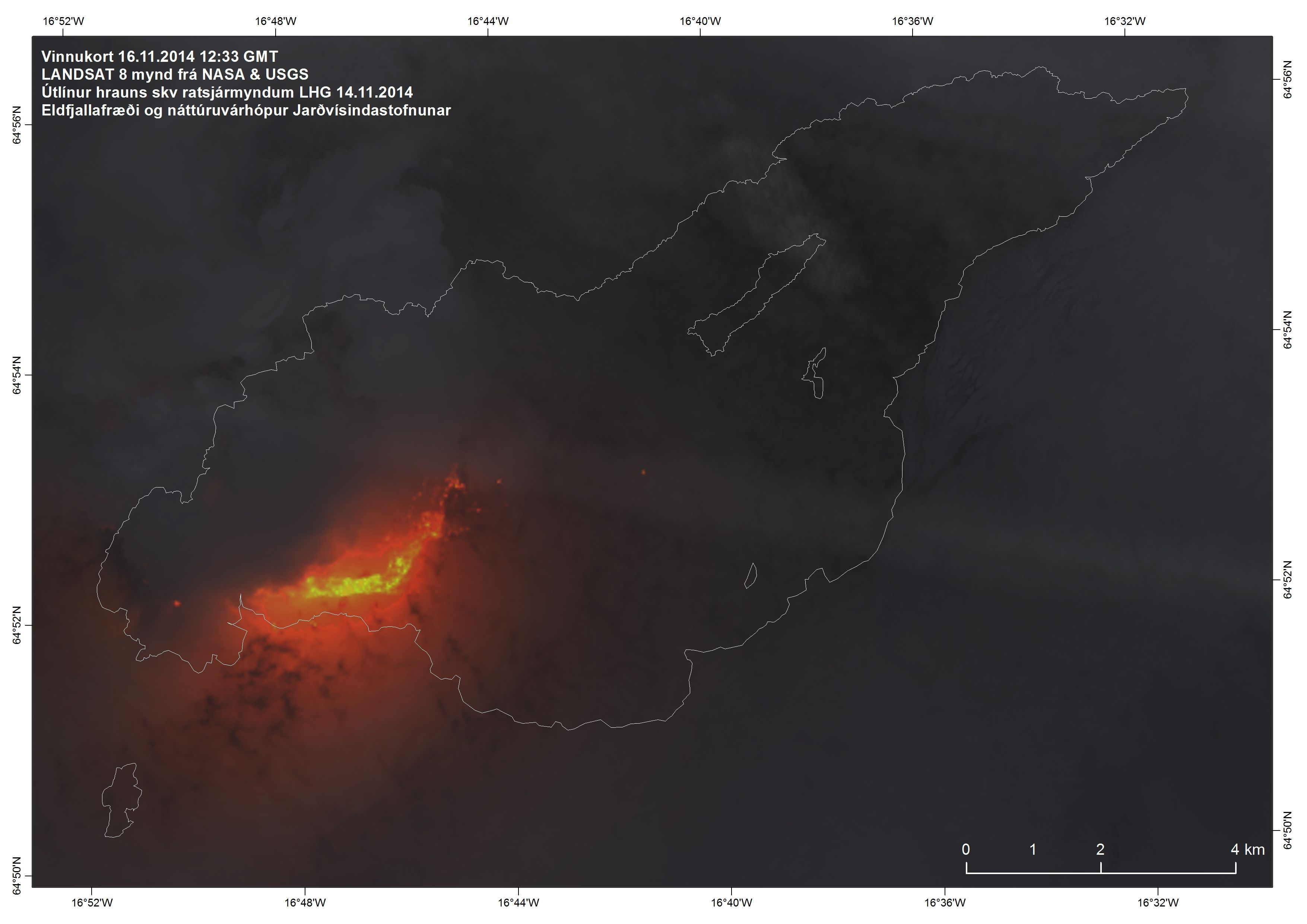
16 November 2014 12:00 - from geoscientist on duty
The largest earthquake since the last report occurred at 01:37 this morning at the northern rim of the Bárðarbunga caldera and was 5.3 in magnitude. Since yesterday morning, 7 quakes over M4 have been detected at Bárðarbunga and all in all about 65 earthquakes in that area. At the northern end of the intrusion 8 or so quakes have been detected, all less than 1.5 in magnitude.

15 November 2014 12:00 - from geoscientist on duty
The largest earthquake since the last report (ten o‘clock yesterday morning) was an M5.4 at the southern rim of the Bárðarbunga caldera at 11:25 (on the 14th). Two quakes were between 4 and 5 in magnitude; first an M4.1 at 01:04 and then a 4.5 at 10:09. All in all, 43 earthquakes have been detected at the Bárðarbunga caldera since 10 AM yesterday. At the nortern end of the intrusion 20 earthquakes were detected, all less than 1.7 in magnitude.
After the 5.4 earthquake yesterday, activity diminished considerably at Bárðarbunga but increased comparably at the northern end of the intrusion, from noon towards evening.
14 November 2014 12:00 - from the Scientific Advisory Board
The volcanic eruption in Holuhraun continues with similar intensity as it has for the last two weeks. Lava continues to flow out of the lava lake in the crater to east southeast. Emission of sulphur dioxide from the crater appears to be constant. Seismic activity in Bárðarbunga continues to be strong but the number of earthquakes stronger then M5.0 seems to be decreasing. The subsidence of the Bárðarbunga caldera continues with similar rate as in the last few weeks although the rate of the subsidence appears to be slower. GPS measurements outside Bárðarbunga show that the horizontal displacement is slowing down.
Notes from the meeting of the Scientific Advisory Board (pdf 0,4 Mb).
14 November 2014 10:00 - from geoscientist on duty
No significant changes were observed regarding the seismic activity around Bárðarbunga and in the dyke intrusion since the last report, yesterday morning.
The strongest earthquakes around the Bárðarbunga caldera were recorded last night, M4.9 at 20:46 on the northwestern caldera rim and M4.8 at 23:08 on the northern rim. Eight additional events were larger than M4 and 21 in the range M3.0-3.9. Alltogether around 70 events were detected around the caldera.
Activity in the dyke intrusion is low. None of the approximately 15 detected earthquakes exceeded M1.5, most of them were located in the northern part of the dyke and a few further south under Dyngjujökull. Minor activity has been detected around Herðubreið and east of Askja.
The eruption in Holuhraun continues at stable levels. Camera observations are limited due to weather, but were occassionally possible yesterday late afternoon. No changes were seen on the camera or reported by scientists in the field.

13 November 2014 - pH of rain water
Large quantities of gases are emitted to the atmosphere associated with the Holuhraun eruption. Among the gases are SO2 that can convert to sulfuric acid causing acid rain.
Since 19th September 2014, rainwater samples have been collected and analysed at weekly bases at 18 locations across all the country. The sampling and analysis have been carried out by Veðurstofan and Háskóli Íslands.
The pH of unpolluted rainwater in Iceland is ~5.6. Rainwater with lower pH is referred to as acid rain and rainwater with higher pH may have interacted with dust in the air and the rain collectors.
The pH of rainwater in Iceland, after the start of the Holuhraun eruption, is ranging from pH 3.2 to 7.5 with an average value of pH 5.8. About 40% of the rain is defined as acid rain whereas 60% can be regarded as unpolluted rain. Less than 1% of the acid rain is however very acid with pH below 4. Stations at Borgir, Reykjahlíð, Írafoss, Hitardalur and Hjarðarland, are among those showing acid rain periodically. It is important to consider that several factors affect the pH of rainwater in addition to the volcanic eruption, the main factors being seaspray, geothermal activity, evaporation and fine rock dust.
The analysis will continue as soon as new samples will be available and the updates will be published on IMO's web-site.
13 November 2014 10:00 - from geoscientist on duty
Seismic activity around Bárðarbunga and in the dyke intrusion during the last 24 hours has been similar to recent days. The strongest earthquakes around the Bárðarbunga caldera since yesterday morning 10:00 were M4.7 at 01:18 last night and M4.5 at 12:38 yesterday, both on the northern caldera rim. 12 additional events were larger than M3 and alltogether around 90 events were detected in this region. Activity in the dyke intrusion remains at low levels. No earthquake exceeded M1.0 and alltogether less than 10 events were detected, all located between the eruption site in Holuhraun and the northern part of Dyngjujökull.
Stable eruption activity is in Holuhraun. Although the eruption can not be seen on any webcams since a few days due to weather conditions, activity is still detected on infrasound arrays and scientists in the field did not report any changes.
12 November 2014 12:00 - from the Scientific Advisory Board
The subsidence of the Bárðarbunga caldera continues with similar rate as last few weeks. Yesterday the GPS station was lifted out of the snow, which is now falling on the glacier. The sharp rise seen in the graph on the web, is the result of this operation.
Notes from the meeting of the Scientific Advisory Board (pdf 0,4 Mb)
12 November 2014 - subsidence measurements reliable again
As explained yesterday, the GPS station had to be lifted so that it would not become covered in snow. This was done by the joint effort of IMO and IES. Work by continued until midnight and it wasn't until this morning, that the readings became reliable. The subsidence graph is now available again. The apparent rise of the caldera on the graph is not real.
12 November 2014 10:00 - from geoscientist on duty
About 60 earthquakes have been detected at Bárðarbunga during the last 24 hours, none above five in magnitude. Ten or so were between four and five in magnitude and the rest was smaller. Low activity in the intrusion. No visibility on webcams towards the eruptive site now.

11 November 2014 - apparent rise and not real
Due to maintainance at noon, the graph of the subsidence of Bárðarbunga caldera showed a false raise of ~1.5 m. The GPS station had to be lifted so that it would not become covered in snow. This ought to have been explained on the web immediately; apologies to our readers. After ten hours of reliable readings, something failed again, so the three day graph has been temporarily removed.
11 November 2014 10:00 - from geoscientist on duty
Over 60 earthquakes were observed in the Bárðarbunga area during the past 24 hours, a bit fewer than the day before. One quake was over magnitude five, at 22:39 M5.1. Five quakes had magnitudes between M4 and M5. There is low activity is in the intrusion. Not much has been seen on webcams due to poor visibility, but a steam plume could be seen on a webcam on Vaðalda.
10 November 2014 11:00 - from the Scientific Advisory Board
Notes from the meeting of the Scientific Advisory Board (pdf 0,4 Mb).
10 November 2014 10:00 - from geoscientist on duty
About 70 earthquakes have been observed in the Bárðarbunga area past 24 hours. The largest quake occurred last night at 21:19, M5.2 in the southeast caldera rim. There are reports that the quake was felt in Eyjafjörður N-Iceland. A few quakes of magnitude between four and five, and a few observed in the intrusion. Currently the eruption is not visible due to poor visibility in the area.
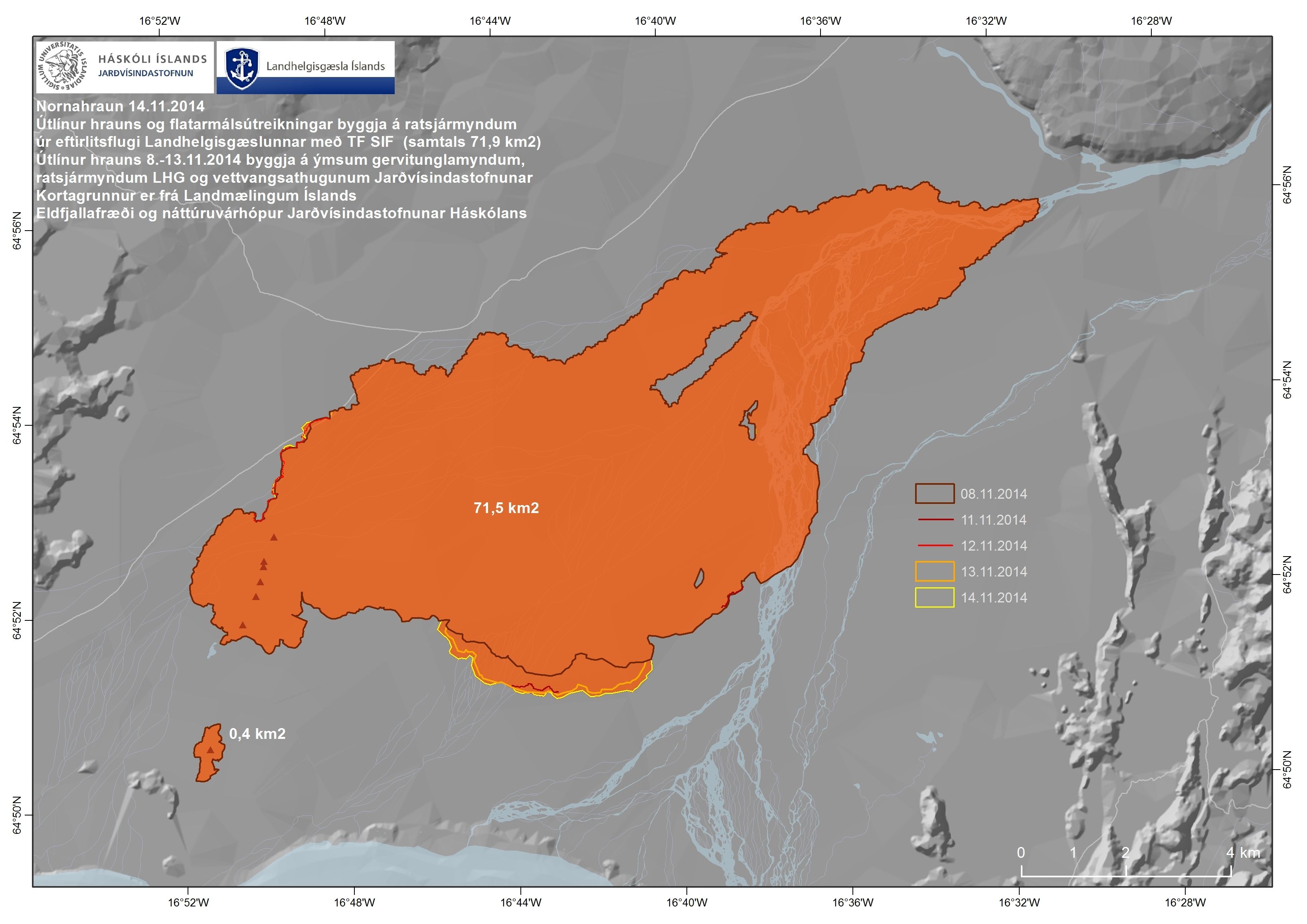
9 November 2014 - the lava now 70 km²

9 November 2014 - GPS data on subsidence is back
The GPS station in the centre of the Bárðarbunga caldera is working and data is being transmitted again (see Subsidence in the header). This turned out to be processing failure due to connection problems.
9 November 2014 12:00 - from geoscientist on duty
Number of observed earthquakes in the Bárðarbunga area past 24 hours is 90. Nine quakes have magnitudes between 4 and 5, the largest M4.6. Low activity is observed in the intrusion.
8 November 2014 - no GPS data on the subsidence
Since last night, Friday 7 November, no data has been transmitted from the GPS station in the centre of the Bárðarbunga caldera (see Subsidence in the header). It is likely that the antenna is covered in snow.
This equipment was mounted on 11 September and has given important information about the subsidence: over 20 m since then. Based on other earlier data, the total subsidence is at least 44 m since the onset of these events.
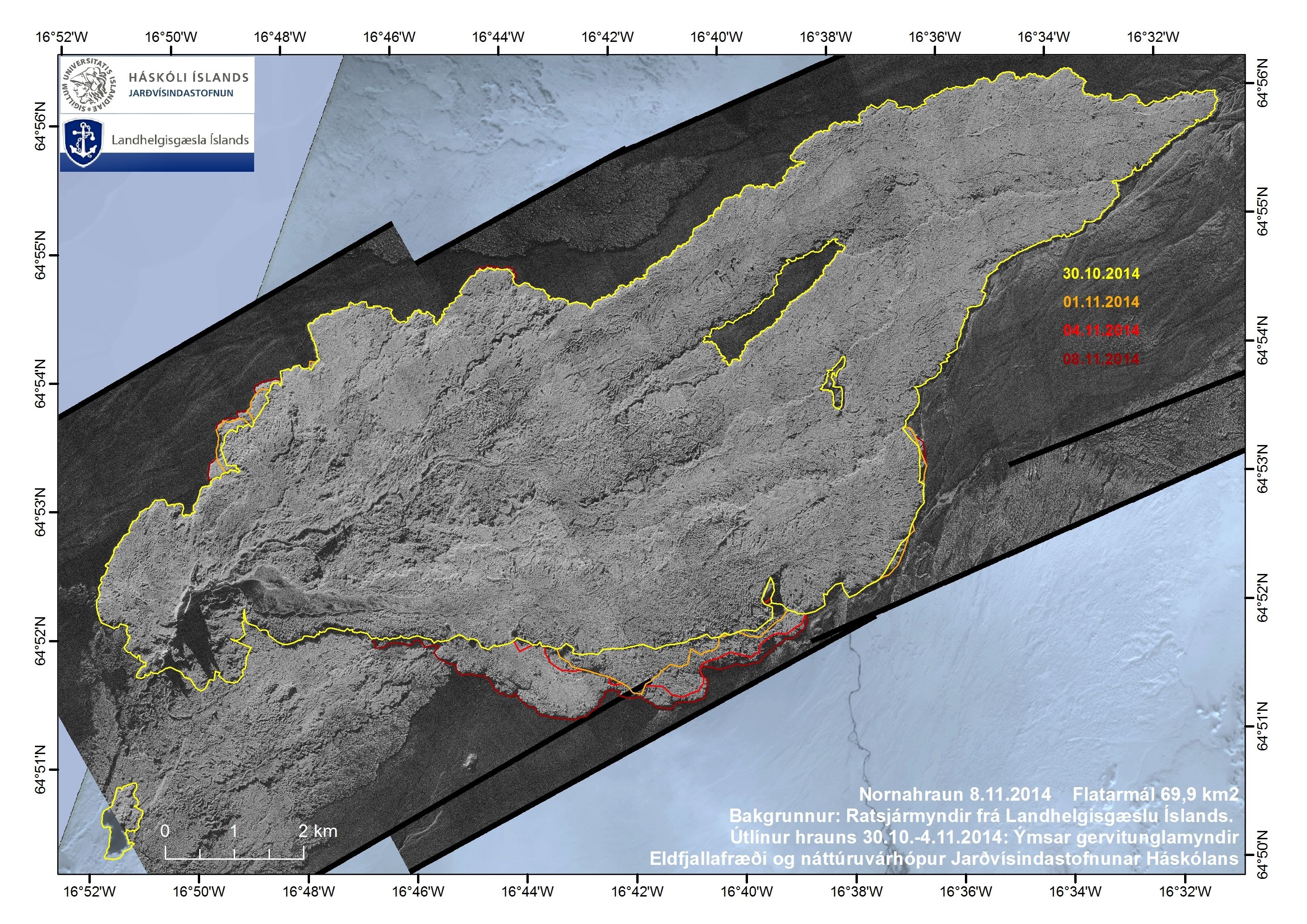
8 November 2014 12:00 - from geoscientist on duty
Yesterday, an M5.4 occurred at the norteastern rim of the caldera and this is the first earthquake over 5 in magnitude since 2nd November. The number of earthquakes since then is about 60. Six quakes between 4 and 5 have been detected and and quite a few between 3 and 4. About 15 earthquakes have been detected in the intrusion, the largest 2.5 in magnitude.
7 November 2014 13:00 - from the Scientific Advisory Board
This morning at 07:11 an earthquake of magnitude 5.4 occurred, the first one over 5 since Sunday. The GPS station in the centre of the Bárðarbunga caldera shows that the subsidence has decreased. However, other measurements indicate that the flow of magma from Bárðarbunga is not decreasing.
Notes from the meeting of the Scientific Advisory Board (pdf 0,4 Mb).
6 November 2014 - observations of gas in Iceland - NEW
New web pages present observations of gas pollution in Iceland (see header). Included is a registration form for the public, a web-viewer showing all public observations and another viewer showing the results of measurements with handheld meters which have been distributed around the country.
6 November 2014 10:00 - from geoscientist on duty
The number of earthquakes during the past 24 hours was 65. The largest occurred at 14:01 yesterday, 4.8 in magnitude. Five earthquakes were between 4 -5 in magnitude and another five between 3 and 4. Only five earthquakes occurred at the northern part of the intrusion, all under 1.5 in magnitude.
5 November 2014 - photos from flight
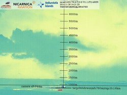
Visibility was good during surveillance flight yesterday, 4 November, with almost no wind. The gas cloud was two layered, from the ground to 700 m hight and in about 1500-2500 m hight.


5 November 2014 14:00 - from the Scientific Advisory Board
The eruption seems unchanged but driving conditions have worsened, hindering field observations. The subsidence of the Bárðarbunga caldera has reached 44 m which corresponds to 1.1-1.2 km³. The adjacent geothermal cauldrons have deepened by 5-8 m in the last eleven days. Horizontal displacements towards Bárðarbunga have decreased slightly.
Notes from the meeting of the Scientific Advisory Board (pdf 0,4 Mb).
5 November 2014 10:00 - from geoscientist on duty
Just over 90 earthquakes have been detected at Bárðarbunga during the last 24 hours. The largest, M4.8, occurred yesterday evening at 20:45. Six earthquakes in the range M4-M5 were detected and about ten in the M3-M4 range. A little less than ten earthquakes were detected under the northern part of the intrusion, all within 2 in size.
4 November 2014 10:00 - from geoscientist on duty
About 100 earthquakes were observed in the Bárðarbunga area past 24 hours, the largest M4.6; several others over M4 and about twenty under M2 in the northern part of the intrusion.
3 November 2014 12:00 - from the Scientific Advisory Board
Conditions at Bárðarbunga are unchanged. See Notes from the meeting of the Scientific Advisory Board.
3 November 2014 10:00 - from geoscientist on duty
About 60 earthquakes have been observed in the Bárðarbunga area past 24 hours, the largest M5,3 and five M4-5. Activity was low in the intrusion.
2 November 2014 12:00 - from geoscientist on duty
About 100 earthquakes have been observed in the Bárðarbunga area past 24 hours, slightly more than the day before. No quake was over magnitude five. Over ten quakes were over magnitude four, the largest M4.6 at 04:30. Activity is low in the intrusion. Webcameras show considerable activity at the eruption site.
1 November 2014 12:00 - from geoscientist on duty
About 80 earthquakes were observed in the Bárðarbunga area past 24 hours. One quake was over magnitude five, last night at 21:32 M5.2. Over ten quakes were over magnitude four, of which seven occurred after midnight. The intrusion has been seismically quiet. Poor visibility prevents observations of the eruption by webcams.
1 November 2014 - number of earthquakes since the onset

A new table (pdf 30 Kb) with the approximate number of events and the total number of events over M3 in size since the onset of the seismic events in northwestern Vatnajökull 16 August 2014. In ordinary circumstances only about 10,000 - 15,000 automatic events occur per year in Iceland. For comparison, an older table is available.
31 October 2014 - another article
Observations from the month of October are found in another comparable article. That article contains an interesting flight report describing scattered veils of gas and also photos of the plume taken in the field.
31 October 2014 - an article in Nature
Nature, the international weekly journal of science, has published an article on these events, called Gas-spewing Icelandic volcano stuns scientist - sulphur rich eruption defies preparations for an ashy blast, by Alexandra Witze.


