
Bárðarbunga 2014 - August events
Seismic events from 16-31 August and the onset of volcanic activity
The August observations (pdf 1.14 Mb) of the onset of the Bárðarbunga seismic and volcanic events are given here with daily notes, factsheets and/or status reports. Information, day by day, is given in reversed order. In combination, the monthly articles give an overview of events: August, September, October, November, December, January, February, March-April-May and the overview article (list of links).
Calendar
Below is a calendar with a short-cut to each day of this month's events:
August: 16-17-18-19-20-21-22-23-24-25-26-27-28-29-30-31 - on the Bárðarbunga central volcano
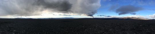 Panoramic view towards the eruptive site in Holuhraun 3rd September 2014. Photo: Richard Yeo.
Updated information
31 August 2014 18:21 - from geoscientist on duty
Few additional facts since status report earlier today: Now about 700 earthquakes have been detected since midnight. An earthquake M4.9 occurred at 16:12 on the northern rim of the Bárðarbunga caldera. The main seismic activity has been in the intrusive dike. Only a few quakes have been located near the caldera rim, mostly its nortern part. Little seismic activity has been near Askja but some seismic activity near Herðubreiðartögl. Weather conditions; very windy.
31 August 2014 16:41 - status report
Overall assessment from the joint status report 310814 of the Icelandic Met Office and the University of Iceland, Institute of Earth Sciences:
Weather conditions made it difficult to follow the progression of the eruption since this morning, but scientists are in the area, using every opportunity to acquire information on gas and lava outflow. Weather conditions do not allow overflight at this time. The Aviation Colour Code for Bárðarbunga was rised at ‘red' this morning and it has been moved back to 'orange' since 15:00 UTC. The color code for Askja is at ‘yellow'.
31 August 2014 14:45 - from meteorologist on duty
Visibility to the eruption site is now good. No ash has has been detected. The Aviation Color Code for Bárðarbunga has therefore been reset to ‘orange' and the code for Askja is still at ‘yellow'.
31 August 2014 12:07 - from the Scientific Advisory Board
Scientists from the Icelandic Met Office and the Institute of Earth Sciences and representatives of the Civil Protection in Iceland attend the meetings of the Scientific Advisory Board of the Icelandic Civil Protection.
Conclusions of the Scientific Advisory Board of the Icelandic Civil Protection:
- A lava eruption started in Holuhraun shortly after 04 AM, on the same volcanic fissure, which erupted earlier this week. The fissure is estimated to be 1,5 km long. It was detected on Míla´s web-camera at 05:51 AM. Fewer earthquakes seem to follow the event than in the previous eruption, but more lava is being extruded.
- At 07 AM the lava flow was around 1 km wide and 3 km long towards northeast. The thickness was estimated a few meters, the flow about 1000 m3 pr second.
- Approximately 500 earthquakes were detected in the area and smaller than before. The strongest earthquake, M3.8 was in the Bárðarbunga caldera. Poor weather conditions prevail in the area, which makes detection of smaller earthquakes difficult.
- GPS measurements show continued movements north of Dyngjujökull.
- Gas emissions rise to a few hundred meters above the fissure.
- Weather conditions make it difficult to follow the progression of the eruption, but scientists are in the area, using every opportunity to acquire information on gas and lava outflow.
- Weather conditions do not allow overflight at this time. The opportunity to fly over the area will be assessed later today.
From the Icelandic Met Office:
The Aviation Colour Code for Bárðarbunga is at ‘red' and the code for Askja at ‘yellow'.
31 August 2014 08:40 - Eruption in Holuhraun observed 05:15
Observation from scientists in the field (05:15): It appears that the eruptive fissure is longer than in the last eruption. It is extending north and south on the same fissure. The eruption is a very calm lava eruption and can hardly be seen on seismometers (almost no gosórói). Visual observation confirm it is calm, but continuous.

The new eruption in Holuhraun at 07:15. Video: Benedikt G. Ófeigsson.
30 August 2014 18:34 - from geoscientist on duty
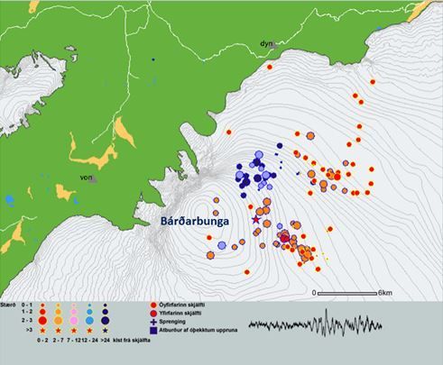
Over 1100 earthquakes have been detected since midnight 29/30 August until 18:30; the vast majority in the northern part of the dyke intrusion, see maps.
As this morning, the active part of the dyke intrusion extends from about 4 km south of the glacier margin of Dyngjujökull to the location of yesterday's fissure eruption. There is no sign of northwards migration of the intrusion.
No large events (M>4) have been detected near the Bárðarbunga caldera since this morning. One event of M2.1 was detected at the northern caldera rim at 13:40. Few small events were detected around Askja volcano.
Summarizing, no significant changes in seismic activity have been observed.
30 August 2014 11:45 - from the Scientific Advisory Board
Scientists from the Icelandic Met Office and the Institute of Earth Sciences and representatives of the Civil Protection in Iceland attend the meetings of the Scientific Advisory Board of the Icelandic Civil Protection.
Conclusions of the Scientific Advisory Board of the Icelandic Civil Protection:
- Earthquake activity continues on a 15-km-long region of the dyke intrusion, extending both into the Dyngjujökull glacier and the region north of the ice margin. Earthquakes have not migrated northwards during the last two days. Seismicity remains high and, since midnight, about 700 earthquakes have been detected in the region.
- The largest earthquakes since midnight include: (i) a magnitude 4.5 event on the northern side of the Bárðarbunga caldera at 02:35 UTC; (ii) a magnitude 4.2 earthquake in the same region at 06:18 UTC; and (iii) a magnitude 5.4 earthquake on the south-eastern edge of the Bárðarbunga caldera at 07:03 UTC. During the last two weeks, several earthquakes of similar size have occurred on the edge of the Bárðarbunga caldera. These earthquakes are interpreted as signs of stress changes in the region of the caldera.
- Over 20 micro-earthquakes have been detected in the Askja region. It is thought that these earthquakes have occurred due to stress changes north of the dyke intrusion.
GPS measurements show continued horizontal movements north of Vatnajökull due to formation of the dyke intrusion on the northern edge of the ice-cap. - No unusual changes in the discharge or electrical conductivity of Jökulsá á Fjöllum have been detected. The same applies to other rivers draining from north-western Vatnajökull.
- A sample of newly erupted lava was taken from Holuhraun yesterday; analysis is ongoing.
There are no indications that the intensity of the activity declining. - At this moment it is unclear how the situation will develop. However, four scenarios are considered most likely:
-
- The migration of magma could stop, resulting in a gradual reduction in seismic activity and no further eruptions.
- The dike could reach the Earth's surface north of Dyngjujökull causing another eruption, possibly on a new fissure. Such an eruption could include lava flow and (or) explosive activity.
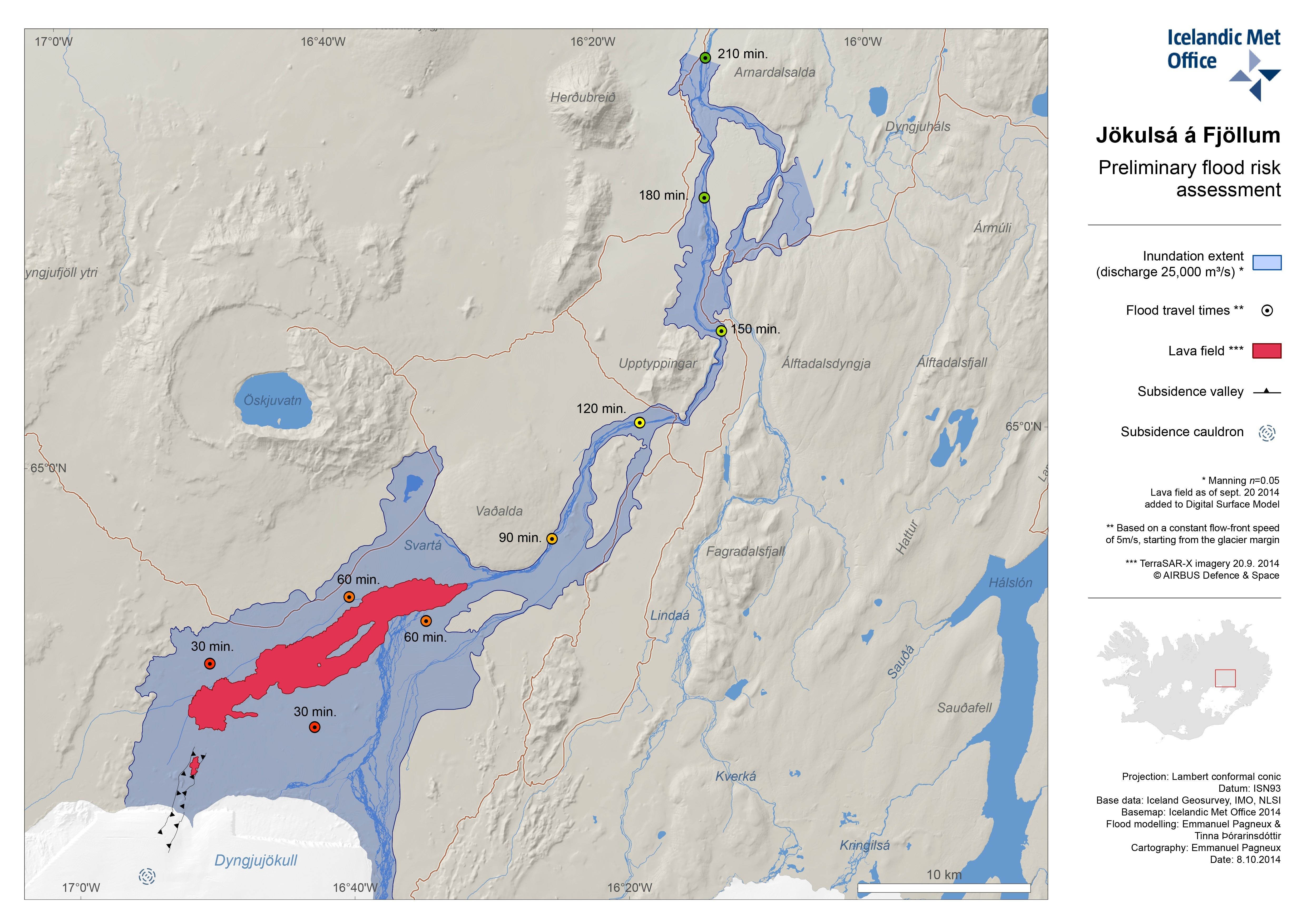
- The intrusion reaches the surface and an eruption occurs again where either the fissure is partly or entirely beneath Dyngjujökull. This would most likely produce a flood in Jökulsá á Fjöllum and perhaps explosive, ash-producing activity.
- An eruption in Bárðarbunga. The eruption could cause an outburst flood and possibly an explosive, ash-producing activity. In the event of a subglacial eruption, it is most likely that flooding would affect Jökulsá á Fjöllum. However it is not possible to exclude the following flood paths: Skjálfandafljót, Kaldakvísl, Skaftá and Grímsvötn.
- Other scenarios cannot be excluded.
From the Icelandic Met Office:
The Aviation Colour Code for Bárðarbunga remains at ‘orange' and the code for Askja at ‘yellow'.
30 August 2014 07:20 - from geoscientist on duty
Around 450 earthquakes have been detected since midnight 29/30 August until 07:00, the vast majority in the northern part of the dike intrusion, see maps.
The active part of the dike intrusion extends from about 4 km south of the glacier margin of Dyngjujökull to the location of yesterday's fissure eruption. Only a few small earthquakes have been located north of the eruption site and there is no sign now of northwards migration of the intrusion. Strongest events in this area were M2.7 at 03:01 and M2.8 at 06:19.
Several events have been detected on the caldera rim of Bárðarbunga, strongest were M4.5 at 02:35 and M4.2 at 06:18, both on the northern rim. A magnitude M5.4 earthquake occurred at 07:03 at the southern rim of Bárðarbunga caldera. Several events of similar size have occurred around the caldera rim in recent days. They are interpreted as possibly being related to subsidence of the volcano due to volume decrease in the magma chamber beneath.
A few small events were detected around Askja volcano.
Summarizing, no significant changes in seismic activity have been observed.
29 August 2014 18:30 - from geoscientist on duty
Little changes since the status report, earlier today. An earthquake M4,1 occurred at 16:27 on the northern rim of Bárðarbunga caldera. The number of earthquakes from the automatic network is similar as at the same time yesterday, about 1200 earthquakes.
29 August 2014 16:20 - Status report
Overall assessment from the joint status report 290814 of the Icelandic Met Office and the University of Iceland, Institute of Earth Sciences:
At this moment it is unclear how the situation will develop. However, three scenarios are considered most likely: * The migration of magma could stop, resulting in a gradual reduction in seismic activity and no further eruptions. * The dike could reach the Earth's surface north of Dyngjujökull causing another eruption, possibly on a new fissure. Such an eruption could include lava flow and (or) explosive activity. * The intrusion reaches the surface and an eruption occurs again where either the fissure is partly or entirely beneath Dyngjujökull. This would most likely produce a flood in Jökulsá á Fjöllum and perhaps explosive, ash-producing activity. At 10:00 UTC, IMO changed the Aviation Colour Code for Bárðarbunga to ‘orange', signifying that significant emission of ash into the atmosphere is unlikely. The aviation colour-code for the Askja volcano remains at ‘yellow'. Other scenarios cannot be excluded. For example, an eruption inside the Bárdarbunga caldera.
29 August 2014 12:20 - from the Scientific Advisory Board
Scientists from the Icelandic Met Office and the Institute of Earth Sciences, and representatives of the Civil Protection in Iceland, attend the meetings of the Advisory Board.
Conclusions of the Scientific Advisory Board:
- At 00:02 UTC signs of a lava eruption were detected on web camera images from Mila. The web-camera is located at Vaðalda, north-east of the eruption site.
- Around midnight, weak signs of increased tremor were apparent on IMO's seismic stations near to the eruption site.
- At 00:20 UTC scientists in the field from the Icelandic Met Office, Institute of Earth Sciences and Cambridge University confirmed the location of the eruption.
- The eruption occurred on an old volcanic fissure on the Holuhraun lava field, about 5 km north of the Dyngjujökull ice margin. The active fissure was about 600 m in length.
- A small amount of lava drained from the fissure and by around 04:00 UTC, lava flow is thought to have stopped.
- According to seismic data and web-camera imagery, the eruption peaked between 00:40 and 01:00 UTC.
- At the beginning of the eruption, seismic activity decreased, although seismicity has since returned to levels observed in recent days.
- Aerial observations by the Icelandic Coastguard show that only steam is rising from the site of the lava eruption.
- There are no indications that the intensity of the activity declining.
- At this moment it is unclear how the situation will develop. However, three scenarios are considered most likely:
-
- The migration of magma could stop, resulting in a gradual reduction in seismic activity and no further eruptions.
- The dike could reach the Earth's surface north of Dyngjujökull causing another eruption, possibly on a new fissure. Such an eruption could include lava flow and (or) explosive activity.
- The intrusion reaches the surface and an eruption occurs again where either the fissure is partly or entirely beneath Dyngjujökull. This would most likely produce a flood in Jökulsá á Fjöllum and perhaps explosive, ash-producing activity.
- Other scenarios cannot be excluded. For example, an eruption inside the Bárdarbunga caldera.
From the Icelandic Met Office:
At 10:00 UTC, IMO changed the Aviation Colour Code for Bárðarbunga to ‘orange', signifying that significant emission of ash into the atmosphere is unlikely. The aviation colour-code for the Askja volcano remains at ‘yellow'.
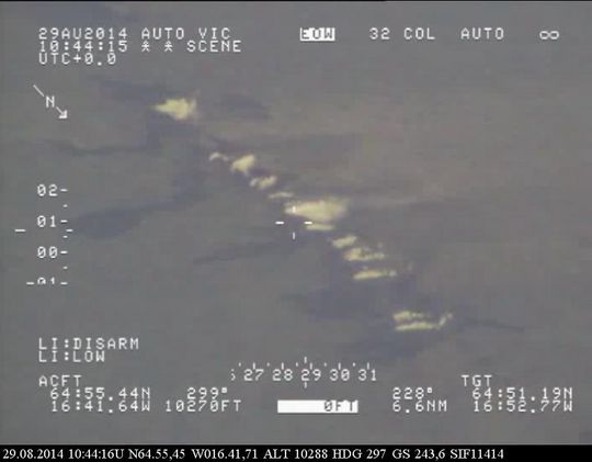
29 August 2014 11:58 - The new eruption in Holuhraun
Below are two images of the new lava in Holuhraun, ca 5 km north of Dyngjujökull. The images were taken from TF-SIF, the aeroplane of the Icelandic Coast Guard. Later, flowmodels were made.

29 August 2014 07:10 - from geoscientist on duty
Seismic activity has decreased as a result of the pressure release, however a significant amount of earthquakes is still detected in the magma dike, between the eruption site and south to about 5 km into Dyngjujökull.
Strongest events were 3.8 in the caldera of Bárðarbunga at 04:37, as well as 2.9 at 05:39 and 3.5 at 06:38 in the dike. These earthquake are very closely monitored, but no significant change volcanic activity following these has been observed so far.
Web camera from Míla shows the area. Míla's background photo has nothing to do with the current event.
29 August 2014 02:45 - An eruption north of Dyngjujökull
An eruption started in Holuhraun north of Dyngjujökull at around 00:02. Seismic tremor was observed on all seismic stations and the web camera installed in the area by Mila has showed some nice pictures of the eruption. It is a small fissure eruption and at 02:40 AM the activity appears to have decreased.
28 August 2014 18:14 - from geoscientist on duty
Since midnight over 1100 earthquakes have been detected by the automatic system. The dyke does not appear to have migrated further north since noon. The main activity is in the dyke and at similar depth as before (8-12km). One earthquake of M5 occurred at 08:13 AM by the northern rim of the Bardarbunga caldera. Two minutes earlier (08:11) another event of M3.9 occurred at a similar location. A few earthquakes were detected near Askja, the biggest one of M2.7.


28 August 2014 12:35 - from the Scientific Advisory Board
Scientists from the Icelandic Meteorological Office and the Institute of Earth Sciences, together with representatives of the Civil Protection in Iceland, met today to discuss the on-going unrest at the Bárðarbunga volcano.
Conclusions of the Scientific Advisory Board:
- This morning, there was a flight over the Bárðarbunga area and the surface of the glacier was surveyed. No changes to the ice crevasses southeast of Bárðarbunga, that were seen yesterday evening, were observed. These crevasses were likely formed due to melting at the ice bottom.
- The depressions have been located southeast of the Bárðarbunga caldera, in all likelihood within the water divide of the river Jökulsá á Fjöllum. There are three circular crevasse formations, about 5 km in total length. The ice thickness in the area is 400-600 m.
- The water level in Grímsvötn Lake has been surveyed and has likely risen by about 5-10 m in the last days, which corresponds to an addition of 10-30 million m³ of water in the lake. A slight increase in conductivity in Köldukvísl River was measured this morning, but the cause is yet unknown. No change has been measured in the Hágöngulón lagoon, Jökulsá River and Skjálfandi River. It is assumed, that the water from the cauldron has flowed into the Grímsvötn Lake or the river Jökulsá á Fjöllum.
- The seismic activity is similar to that of the last days. Around midnight, three earthquakes of magnitude around 4 were recorded and one of magnitude 5 at 08:13 this morning, all located within the Bárðarbunga caldera.
- Shortly before 08:00 this morning, there was a slight increase in seismic activity in the Askja volcano. Changes in the stress field due to expansion caused by the dyke have an effect on the Askja area.
- Since yesterday, the length of the dyke under Dyngjujökull has increased by 1-1.5 km to the north, which is considerably less than in the last days. The dyke has now reached the fissure system of the Askja volcano and GPS measurements indicate that the area there is greatly affected.
- The conclusions from the meeting of the Scientific Advisory Board of the Icelandic Civil Protection will continue to be published at around noon, after the meeting, if necessary.
From the Icelandic Met Office:
The Aviation Colour Code remains at the ‘orange' level for Bárðarbunga.
28 August 2014 06:17 - from geoscientist on duty
Activity in the Bardarbunga area 00:00-06:00 August 28 2014.
Activity continues in similar manner as before. It was slightly less then the night before.
Two events in Bardarbunga recorded, magnitude 4.1 and 4 at 1:30 and 3:30 resp.
Most events recorded were located within the northernmost 10 km of the dike and few small
earthquakes around Askja.
Total events automatically detected from midnight until now are 400.
27 August 2014 20:50 - info from a surveillance flight
Scientists from IES and IMO on a flight to Vatnajökull tonight discovered a row of 10-15 m deep cauldrons south of the Bárðarbunga caldera. They form a 6-4 km long line. The cauldrons have been formed as a result of melting, possibly a sub-glacial eruption, uncertain when. Heightened tremor level/volcanic tremor has not been observed on IMO's seismometers at the moment. The new data is being examined.

27 August 2014 18:42 - from geoscientist on duty
Almost 1300 earthquakes have been detected in the automatic network since midnight. This activity has mostly been in the intrusive dike, which now stretches some 12 km north of the glacier‘s edge. A few earthquakes have also been detected near the Bárðarbunga caldera, the largest one M2.7. No signs of volcanic tremor.
27 August 2014 11:50 - from of the Scientific Advisory Board
Scientists from the Icelandic Meteorological Office and the Institute of Earth Sciences, together with representatives of the Civil Protection in Iceland, met today to discuss the on-going unrest at the Bárðarbunga volcano.
Conclusions of the Scientific Advisory Board:
- Intense seismicity continues. Over 700 earthquakes have been recorded since midnight. Earthquakes are occurring mostly beyond the edge of the Dyngjujökull glacier and the intrusion itself has migrated about 1 km northwards since yesterday.
- At 00:16 UTC today, a magnitude 5.3 earthquake occurred in the caldera of Bárðarbunga. At 02:50 UTC, another similar-sized earthquake (magnitude 5.2) took place in the same region.
- At 01:52 UTC, a magnitude 4.5 earthquake was detected on the eastern side of the Askja volcano. This was followed by a few micro-earthquakes in the same area.
- The dyke intrusion beneath Dyngjujökull is thought to be about 40 km in length.
- Modelling of GPS data indicates that about 20 million cubic metres of magma have been added to the volume of the intrusion in the last 24 hours.
- Modelling results suggest that the dyke intrusion is causing stress changes over a large area, including the region to the north of the dyke's extent; this could account for the increased seismicity at Askja volcano.
- There are no indications that the intensity of the activity declining.
- From today, the afternoon status report will no longer be produced. However, if the situation escalates (i.e. imminent signs of an eruption), daily status reports will be reintroduced. The results of the scientific advisory board will continue to be distributed daily at around midday.
From the Icelandic Met Office:
The Aviation Colour Code remains at the ‘orange' level for Bárðarbunga.
27 August 2014 06:30 - from geoscientist on duty
The night started with a 5.3 event in Bardarbunga at 00:16 hours.
Around half an hour later activity around the tip of the dyke started increasing and reached some kind of "high" around 2 o'clock and has continued at that level since with many events of magnitude 2-3.
Just before 2 o'clock there was a magnitude 4.5 event just east of the Askja caldera. Few microearthquakes have been measured there earlier this week.
At 02:50 there was a 5.2 event again in Bardarbunga.
Total events automatically detected from midnight until now are 500, most of them around the tip
of the northward migrating dyke.
Implications of Askja event is still premature to speculate on. However, we are watching the area closely.
There seems to be a slight increase in activity compared to same time. The >M5 events in Bardarbunga are still interpreted as being relaxation process of the caldera due to magma pressure changes and the propagating dyke.
26 August 2014 17:53 - from geoscientist on duty
Just under 900 earthquakes have been detected by the network since midnight, somewhat fewer than at the same time yesterday. The intrusive dike is now about 40 km long. Most of the activity has been near the edge of the glacier. An earthquake M4.6 (EMSC M4.4) occurred at 11:56. Reports were received from Akureyri (a town in northern Iceland) that the earthquake was found there. The earthquakes are mostly on similar depth as before, i.e. 8-12 km. A few were larger than M3. Few earthquakes were located in the Bárðarbunga caldera today.

26 August 2014 15:45 - status report
Overall assessment from the joint daily status report 260814 of the Icelandic Met Office and the University of Iceland, Institute of Earth Sciences:
There are no indications that the intensity of the activity declining. Currently, three scenarios are considered most likely: 1) The migration of magma could stop, attended by a gradual reduction in seismic activity. 2) The dike could reach the surface of the crust, starting an eruption. In this scenario, it is most likely that the eruption would be near the northern tip of the dike. This would most likely produce an effusive lava eruption with limited explosive, ash-producing activity. 3) An alternate scenario would be the dike reaching the surface where a significant part, or all, of the fissure is beneath the glacier. This would most likely produce a flood in Jökulsá á Fjöllum and perhaps explosive, ash-producing activity. Other scenarios cannot be excluded. For example, an eruption inside the Bárdarbunga caldera is possible but at present considered to be less likely.
26 August 2014 11:50 - from the Advisory Board of scientists
Scientists from the Icelandic Met Office and the Institute of Earth Sciences, and representatives of the Civil Protection in Iceland, attend the meetings of the Advisory Board.
The following points were the conclusion at a meeting of the Advisory Board today:
- Intense seismicity continues. Over 500 events have been recorded since midnight.
- Seismicity continues to migrate northward. Seismicity is now concentrated on the 10 km long tip of the dike extending 5 km beyond the edge of the Dyngjujökull glacier.
- At 01:26 this morning an earthquake of magnitude 5,7 was observed beneath the
Bárðarbunga caldera. - The dyke beneath Dyngjujökull is now thought to be close to 40 km long. Modelling
of GPS data indicates that about 50 million cubic meters of magma have added to the volume in the last 24 hours. - There are no indications that the intensity of the activity declining. The following three scenarios are still considered most likely:
-
- The migration of magma could stop, accompanied by a gradual reduction in seismic activity.
- The dike could reach the surface of the crust, starting an eruption. In this scenario, it is most likely that the eruption would be near the northern tip of the dyke. This would most likely produce an effusive lava eruption with limited explosive, ash-producing activity.
- An alternate scenario would be the dyke reaching the surface where a significant part, or all, of the fissure is beneath the glacier. This would most likely produce a flood in Jökulsá á Fjöllum and perhaps explosive, ash-producing activity.
- Other scenarios cannot be excluded. For example, an eruption inside the Bárðarbunga caldera is possible but presently considered to be less likely.
From the Icelandic Met Office:
The Aviation Color Code remains at the "orange" level.
26 August 2014 06:45 - from geoscientist on duty
Seismic activity continues to be high.
Biggest earthquake in the current swarm was measured this night at 01:26. According to USGS the magnitude was 5.7. The event was localized in the northern/northwestern part of Bardarbunga caldera at 6 km depth.
Most of the seismic activity is close to the rim of Dyngjujokull. The dyke is still migrating to the north and the tip of it is already around 10 km outside of the glacier. Most of the events are at the depth of 8-12 km.
There have been no signs of harmonic tremor.

25 August 2014 19:09 - from geoscientist on duty
Until 19:00 today, around 1.200 earthquakes have been automatically detected under northwestern Vatnajökull. The vast majority have been around the northernmost tip of the dyke intrusion at Dyngjujökull. The tip of the earthquake cluster has migrated further to 6-7 km north of Dyngjujökull. More than 20 events at the tip of the intrusion were between M3 and M4. Event depths are still around 5-12 km, no sign of upwards migration or low frequent tremor. One earthquake M5.1 occurred within the Bárdarbunga caldera at 16:19 today. Otherwise, little activity has been within the caldera today. See live link to self-updating maps.
25 August 2014 16:00 - status report
Overall assessment from the joint daily status report 250814 of the Icelandic Met Office and the University of Iceland, Institute of Earth Sciences:
There are no indications that the intensity of the activity is declining. Currently, three scenarios are considered most likely: 1) The migration of magma could stop, attended by a gradual reduction in seismic activity. 2) The dike could reach the surface of the crust, starting an eruption. In this scenario, it is most likely that the eruption would be near the northern tip of the dike. This would most likely produce an effusive lava eruption with limited explosive, ash-producing activity. 3) An alternate scenario would be the dike reaching the surface where a significant part, or all, of the fissure is beneath the glacier. This would most likely produce a flood in Jökulsá á Fjöllum and perhaps explosive, ash-producing activity. Other scenarios cannot be excluded. For example, an eruption inside the Bárdarbunga caldera is possible but presently considered to be less likely.
25 August 2014 11:00 - from the Advisory Board of scientists
Scientists from the Icelandic Met Office and the Institute of Earth Sciences and representatives of the Civil Protection in Iceland attend the meetings of the Advisory Board.
Presented at a meeting of the Advisory Board at 10 am today:
- Intense seismicity continues. Over 700 events have been recorded since midnight.
- Seismicity continues to migrate northward. Seismicity is now concentrated on the 10 km long tip of the dike extending 5 km beyond the edge of the Dyngjujökull glacier.
- At 20:39 last night an earthquake of magnitude ~5 was observed beneath the Bárðarbunga caldera. Since then earthquakes in the caldera have been smaller.
- The dike beneath Dyngjujökull is now thought to be close to 35 km long. Modelling of GPS data indicates that it contains about 300 million cubic meters of magma.
- Additional stations for continuous GPS monitoring will be installed north of Vonarskarð and on Urðarháls within a few days.
- There are no indications that the intensity of the activity declining. Currently, three scenarios are considered most likely:
-
- The migration of magma could stop, attended by a gradual reduction in seismic activity.
- The dike could reach the surface of the crust, starting an eruption. In this scenario, it is most likely that the eruption would be near the northern tip of the dike. This would most likely produce an effusive lava eruption with limited explosive, ash-producing activity.
- An alternate scenario would be the dike reaching the surface where a significant part, or all, of the fissure is beneath the glacier. This would most likely produce a flood in Jökulsá á Fjöllum and perhaps explosive, ash-producing activity.
- Other scenarios cannot be excluded. For example, an eruption inside the Bárðarbunga caldera is possible but presently considered to be less likely.
From the Icelandic Met Office:
The Icelandic Met Office has decided that the aviation colour code will remain orange.
25 August 2014 08:15 - from geoscientist on duty
At 07:30 UTC about 500 events have been automatically detected. Most of them were along the northern tip of the propagating dike intrusion northeast of Bárðarbunga volcano at about 5 km segment outside the northern margin of the outlet glacier Dyngjujökull.
At the northernmost segment of the dike, nine earthquakes were larger than M3 and three of them about M3.5. The earthquakes' depths are still below 5 km (mostly around 10 km).
No large events were detected at the Bárðarbunga caldera since midnight.
There is no sign of volcanic (harmonic) tremor.

24 August 2014 21:41 - from scientist on duty
Tonight, at 20:39 an earthquake about M 5 occurred at Bárðarbunga. The European-Mediterranean seismological centre, EMSC, estimates the magnitude at 4.9. On the self-updating maps, the earthquake can be seen as a distinctive ring on the caldera's eastern rim. Intense earthquake activity continues, although there is presently no sign of volcanic tremor.
24 August 2014 19:00 - from geoscientist on duty
Until 19:00 today, 24. August, around 1.300 earthquakes have been automatically detected under northwestern Vatnajökull. The vast majority is around the northernmost tip of the dike intrusion at Dyngjujökull.
The tip of the earthquake cluster has migrated throughout the night and today to 4 km north of Dyngjujökull. The propagation of the intrusion was slower than yesterday.
More than 20 events at the tip of the intrusion were stronger than M3, four of them M4-M4.3. Event depths are still around 5-12 km, no sign of upwards migration or low frequent tremor.Following the M5.3 and M5.1 earthquakes in the caldera of Bárðarbunga, one M4.8 (15:00) and several smaller events occurred in the caldera.
Focal mechanisms of the strongest events indicate subsidence of the volcano due to volume decrease underneath, similar to past days.
24 August 2014 16:12 - status report
Overall assessment from the joint daily status report 240814 of the Icelandic Met Office and the University of Iceland, Institute of Earth Sciences:
There are no indications that the activity is slowing down, and therefore an eruption can not be excluded. Observations show that a sub-glacial eruption did not occur yesterday. The intense low-frequency seismic signal observed yesterday has therefore other explanations. The Icelandic Meteorological Office has decided to move the aviation colour-code from red to orange.
24 August 2014 13:30 - the low tremor graph
The intense low-frequency seismic signal observed yesterday is described in another article.
24 August 2014 11:50 - notes from scientists' meeting
- Earthquake activity in NW-Vatnajökull is still very strong, 700 earthquakes have been observed since midnight and they are somewhat larger than previous days.
- Two large earthquakes, over 5 where in the Bárðarbunga caldera this night.
- The activity under Dyngjujökull has propagated northwards and is now mostly under the edge of the glacier, where an earthquake of size 4,2 was recorded this morning.
- The dike under Dyngjujökull is now estimated to be approximately 30 km long.
- There are no indications that the activity is slowing down, and therefore an eruption can not be excluded.
- Observations show that a sub-glacial eruption did not occur yesterday. The intense low-frequency seismic signal observed yesterday has therefore other explanations.
- The Icelandic Meteorological Office has decided to move the aviation color-code from red to orange.
24 August 2014 06:48 - from geoscientist on duty
Two M5 earthquakes took place in Bárðarbunga caldera during the night:
A magnitude 5.3 earthquake occurred at 5 km depth just after midnight, at 00:09. Its origin was at the northern rim of the caldera. Another earthquake, magnitude about 5, occurred at 05:33 and originated at the southern rim. These are the strongest events measured since the onset of the seismic crisis at Bárðarbunga and the strongest since 1996 (the Gjálp eruption). The magnitude is already confirmed by the European EMSC network and the GEOFON network of GFZ Potsdam in Germany.
Probably, earthquakes near the Bárðarbunga caldera are a consequence of adjustment to changes in pressure because of the flow of magma from under the caldera into the dike which stretches to Dyngjujökull, more than 25 km away.
Great seismic activity is also near the intrusive dike in Dyngjujökull. The activity is concentrated at the section which advanced northwards yesterday morning. Analysis shows that the origin of the quakes, there, has migrated a little towards north. Their depth is mainly in the range of 8-13 km. The largest earthquake in the Dyngjujökull area was 3.5 at 04:39.
No signs of tremor, indicative of eruption, were detected during the night.

23 August 2014 20:30 - notes from scientists
- At 11:20 UTC today, seismic tremor measurements gave a strong indication that an eruption beneath Dyngjujökull was occurring. Tremor levels decreased during the afternoon, although intense earthquake activity continues.
- At 14:00 UTC, an over-flight was made to Bárðarbunga by the Icelandic Coastguard with scientists from the Icelandic Meteorological Office and the University of Iceland, in addition to a representative from the National Commissioner of the Icelandic Police.
- The over-flight covered the north-western region of the Vatnajökull ice-cap in clear conditions. Both visual observations and radar measurements confirmed no significant changes on the surface of Vatnajökull. Likewise, there were no signs of floodwater draining from the ice margin.
- During three hours of aerial surveillance, there were no obvious signs of volcanic activity.
- In light of the intense, ongoing earthquake activity and crustal deformation at Bárðarbunga, the Icelandic Meteorological Office has decided that the aviation colour-code should remain ‘red', signifying that an eruption is either imminent or in progress. The situation will be reassessed tomorrow morning.
23 August 2014 17:08 - status report
Overall assessment from the joint daily status report 230814 of the Icelandic Met Office and the University of Iceland, Institute of Earth Sciences:
The aviation color code has been raised to "red" as the data is currently interpreted as a subglacial eruption. Both the thickness of the ice at the possible contact point (100-400 m) and the volume of lava in possible contact with ice are highly uncertain. It could be 0-20 hours before lava reaches the surface of the ice. It is also possible that the lava will not break through the ice, and the eruption could remain subglacial.
23 August 2014 14:10 - a small eruption under Dyngjujökull suspected
- A small lava-eruption has been detected under the Dyngjujökull glacier. (Note: on IMO's Icelandic web-site this point read "is suspected"; see corrections in English later this day).
- The Icelandic Coast Guard airplane TF-SIF is flying over the area with representatives from the Civil Protection and experts from the Icelandic Met Office and the Institute of Earth Sciences. Data from the equipment on board is expected later today.
- Data from radars and web-cameras is being received, showing no signs of changes at the surface.
- The estimate is that 150-400 meters of ice is above the area.
- The aviation color code for the Bárðarbunga volcano has been changed from orange to red.
- Some minutes ago (14:04), an earthquake occurred, estimated 4.5 in magnitude.
23 August 2014 12:20 - notes from the scientists' meeting
Intense earthquake activity continues at the Bárðarbunga volcano – a situation that has persisted since 16 August.
During the last 6 hours the dike has propagated ~5 km to the north. The rate of earthquakes has increased such that they are happening so quickly that it is difficult for the seismologist to discern individual events. Observed high frequency tremor is interpreted to be caused by the propagation of the dike.
Some larger earthquakes of magnitude 3 - 4 have been measured in the Bárðarbunga caldera in the last days. These events in the Bárðarbunga caldera are interpreted as adjustments related to decompression in the caldera since the beginning of the unrest.
Most recent GPS data shows that magma flow is continuing.
The Coast Guard TF SIF aircraft is taking off by 13:00 to make observations with scientists from Icelandic Met Office, the Institute of Earth Sciences, and people from the Civil Protection.
A tourist plane called in at noon to report no visible changes at the surface.
Current winds: weak winds at low levels. At higher levels winds are northerly (towards the south).
Hydrological measurements at Jökulsá á Fjöllum, Upptypingar, do not indicate a contribution of geothermal/volcanic gases to the hydrological system that is outside of the typical range observed in the last decade.
The activity continues and an eruption can therefore not be ruled out.
The aviation colour-code for the Bárðarbunga volcano remains unchanged at ‘orange', and we are continuously evaluating if this should be changed. The volcano is exhibiting heightened levels of unrest.
22 August 2014 17:00 - status report
Overall assessment from the joint daily status report 220814 of the Icelandic Met Office and the University of Iceland, Institute of Earth Sciences:
There are no measurements to suggest that an eruption is imminent. Previous intrusion events in Iceland have lasted for several days or weeks, often not resulting in an eruption. However an eruption of Bárðarbunga cannot presently be excluded, hence the intense monitoring and preparation efforts. The ongoing monitoring and assessment effort is necessary in case a volcanic eruption occurs. Hazards in the event of an eruption are being assessed, including a glacial outburst flood and dispersal of volcanic ash. Additional seismic, GPS and hydrological stations have been installed in the Bárðarbunga region. Likewise, mobile radars capable of monitoring ash dispersal have been moved to the region. The aviation colour-code for the Bárðarbunga volcano remains unchanged at ‘orange', signifying that the volcano is exhibiting heightened levels of unrest.

22 August 2014 13:00 - notes from the scientists' meeting
Intense earthquake activity continues at the Bárðarbunga volcano – a situation that has persisted since 16 August. There are no signs that the seismicity is decreasing. A 25 km long dike has formed in the crust under the Dyngjujökull glacier at 5-10 km depth. Interpretation of the latest data suggests that the magma continues to move along the dike, possibly branching at the northeast end of the dike.
One earthquake of magnitude 4.7 was measured in the Bárðarbunga caldera at 4 km depth yesterday evening at 23:50. This large event was at similar location as earthquakes of magnitude larger than three that were seen yesterday. Large events in Bárðarbunga are interpreted as adjustments of the caldera rim related to decompression in the caldera since the beginning of the unrest. The activity continues and an eruption can therefore not be ruled out.
There are no signs of increased conductivity through geothermal activity into the rivers.
From the beginning of the activity, measurements done with GPS have shown displacements on the surface of over 14 cm, 15 - 20 km from Dyngjuháls. In comparison, Iceland on the whole is spreading at the rate of about 2 cm pr. year.
A new GPS station in Kverkfjöll is now running and sending data. Similar seismic instruments were installed by Kverkfjöll yesterday, as well as close to the GPS station at Hamarinn, which was set up two days ago. In addition, two seismic stations set up in Dyngjujökull yesterday are collecting data on site. This work is done in collaboration between IMO, the Institute of Earth Sciences and collaborators in the European FutureVolc research project.
The aviation colour-code for the Bárðarbunga volcano remains unchanged at ‘orange', signifying that the volcano is exhibiting heightened levels of unrest.
22 August 2014 06:40 - from geoscientist on duty
Seismic activity in Bárðarbunga and Dyngjujökull is still great. It diminished somewhat after two o‘clock in the morning. Almost 400 quakes have been detected by the automatic network since midnight and, as in recent days, the majority of them is located east of Bárðarbunga, next to the intrusion. Most of the manually processed earthquakes turn out to be at great depth, 8-12 km, but a few at the very northeastern tip of the intrusion have been positioned at shallower depths, up to just under 4 km.
Just before midnight, 21st August at 23:50:22, an earthquake occurred at Bárðarbunga which measured 4.7-4.8 in magnitude. Another one reached M3. During the last days quite a number of quakes has been detected within the Bárðarbunga caldera, or on the rims, at a depth of 2-6 km. Probably these earthquakes derive from changes in pressure when magma is drawn eastward into the huge intrusion and away from the magma chamber under the caldera.

21 August 2014 17:00 - status report
Overall assessment from the joint daily status report 210814 of the Icelandic Met Office and the University of Iceland, Institute of Earth Sciences:
There are no measurements to suggest that an eruption is imminent. Previous intrusion events in Iceland have lasted for several days or weeks, often not resulting in an eruption. However an eruption of Bárðarbunga cannot presently be excluded, hence the intense monitoring and preparation efforts. The ongoing monitoring and assessment effort is necessary in case a volcanic eruption occurs. Hazards in the event of an eruption are being assessed, including a glacial outburst flood and dispersal of volcanic ash. Additional seismic, GPS and hydrological stations have been installed in the Bárðarbunga region. Likewise, mobile radars capable of monitoring ash dispersal have been moved to the region. The aviation colour-code for the Bárðarbunga volcano remains unchanged at ‘orange', signifying that the volcano is exhibiting heightened levels of unrest.
21 August 2014 15:00 - a few facts
Today, three earthquakes exceeding 3 in magnitude have occurred on the caldera rim of Bárðarbunga (M 3.7 at 10:29, M 4.0 at 10:58 and M 3.4 at 13:02). These earthquakes were at depths around 2 - 5 km. They are interpreted as possible adjustments of the caldera due to changing magma pressure – they are not assumed to be the precursor to an imminent eruption.
21 August 2014 12:00 - notes from the scientists' meeting
- No signs of diminishing activity around Bárðarbunga
- An intrusion, 25 km long, has formed beneath Dyngjujökull, at a depth of 5-10 km
- The aircraft TF-SIF, from the Icelandic Coast Guard, is now available for scientists
- The aviation colour code is still orange
The seismic activity in Bárðarbunga, first noticed 16th August, has maintained its strength and there are no signs of its retreat. Deformation measurements, GPS, indicate that a 25 km long intrusion is forming underneath Dyngjujökull. Earthquake measurements support the conclusion that the magma is still at 5-10 km depth. There are no signs of upward migration of the activity.
Collateral interpretation of the latest data suggests that the intrusion is expanding at its northeastern end, whereas its length has only increased a little in the last 24 hours.
In the Bárðarbunga caldera, where it all started, earthquakes still occur; probably because of slight subsidence due to the outward flow of magma from the magma-chamber under the caldera.
The measuring network in the area is being improved; just now technicians from the Icelandic Met Office, from the Institute of Earth Sciences and from foreign research institutions are mounting additional equipment on the ice-cap and at its margin. Already, many devices which have been implanted in recent years as part of the international FutureVolc project, are running and providing important information which has been useful in both monitoring and analysis of these events.
Yesterday, a reconnaissance flight was made over the area with the Icelandic Coast Guard. The aircraft TF-SIF, now dedicated to these events, has specialised equipment on board for monitoring changes in the surface of the ice-cap and monitoring outburst floods. No signs of change were detected during this flight. With open access to this aircraft, which was withdrawn from its current tasks at the Mediterranean, scientist are now in a much better position to monitor possible volcanic activity and flooding.
20 August 2014 17:05 - status report
Overall assessment from the joint daily status report 200814 of the Icelandic Met Office and the University of Iceland, Institute of Earth Sciences:
There have been no observations of migration to the surface or any other signs of imminent or ongoing volcanic activity. We cannot exclude that the current activity will result in an explosive subglacial eruption, leading to an outburst flood (jökulhlaup) and ash emission.
19 August 2014 20:00 - from geoscientist on duty
Around 1.000 small earthquakes have been detected in the Bárðarbunga region since midnight today. All of them were smaller than magnitude 3 and most were located in the cluster east of Bárðarbunga. While the northern cluster close to Kistufell has calmed down significantly following the M4.5 earthquake on early Monday morning, event rates in the eastern cluster are still high. Similar to recent days, two pulses of comparably strong seismic activity have been measured between 04:00 and 08:00 this morning, as well as 16:00 and 18:30 in the afternoon. The cluster east of Bárðarbunga continued to slowly migrate northeastwards today. Events are still located at around 5-12 km depths, no sign of upwards migration has been seen so far. A map of these events was given in a news-article on our front page.
19 Agust 2014 13:36 - earthquakes 1991-2014
This graph shows the yearly number of earthquakes from the onset of seismic measurements at Bárðarbunga in 1991. The blue dashed line shows the number of all measured earthquakes but the red line shows the number of earthquakes above 1.5 in magnitude.
During these years, the measuring net has improved and become more sensitive. That is the reason for showing the larger earthquakes separately.

18 August 2014 20:45 - An overview of the first three days
Since the onset of the earthquake swarm at Bárðarbunga on Saturday morning, around 2.600 earthquakes have been detected with the earthquake monitoring network of the Icelandic Meteorological Office (IMO). Throughout the whole sequence the majority of events has been at 5-10km depth. No signs of migration towards the surface or any other signs of imminent or ongoing volcanic activity have been detected. IMO is monitoring the area closely and will update in case of any changes. A more thorough overview was given in a news-article on the front page.
17 August 2014 - a field trip
At 10 a.m. on Sunday the 17th the Board of scientists decided, because of the intense seismic activity in Bárðarbunga, to attempt to install a seismometer closer to the swarm.
The Icelandic Met Office has been preparing the installation of two permanent seismic stations in the Vatnajökull ice cap as a part of the FutureVolc project. As a part of the preparation, two test sites were set up last January. One was installed at Dyngjujökull and the other at Brúarjökull. On these two locations, equipment for power generation and communication were installed.
Since the infrastructure at the Dyngjujökull test site had been working well, it was chosen as the ideal location for the installation of the new seismometer, which was loaned by the University of Cambridge, a partner in the FutureVolc project. At 16:00, only six hours after the decision was made, the Icelandic Coast Guard's helicopter left towards the ice cap.
A stop was made at Grímsfjall and a technician repaired the web cameras that are located there. Next they headed to Dyngjujökull where technicians from IMO and the Institute of Earth Sciences, and a scientist from the University of Cambridge, installed the seismometer. The manager of the Civil Protection of NCIP participated in this field trip as well. The installation was successful and only two hours later data was streaming to the Icelandic Met Office.
It is quite an achievement to install a seismometer on Vatnajökull on such short notice and it would not have been possible without well trained employees, good access to equipment and the goodwill of the Icelandic Coast Guard.


16 August 2014 19:49 - Seismic activity in Bárðarbunga
Seismic activity in Bárðarbunga volcano has increased. A seismic swarm has been ongoing since 03AM this morning, and near continuous earthquakes have been occurring since then. The depths of earthquakes in the present swarm are in the upper crust and their magnitudes are mainly around 1.5; a few earthquakes are of magnitude greater than ML3.
Long-term seismic and GPS data indicate that there is increased unrest in the northwestern region of Vatnajökull glacier, where Bárðarbunga is located.
Over the last seven years seismic activity has been gradually increasing in Bárðarbunga and the fissure swarm north of the volcano. This activity dropped down at the Grímsvötn eruption in May 2011, but soon after, the activity started to gradually increase again and has now reached similar level of activity to that just before the Grímsvötn eruption. Earlier this year, in the middle of May 2014, there was a small swarm of over 200 events and now the present swarm has already generated at least 300 earthquakes.
Since early June 2014, displacements at GPS stations around Vatnajökull show velocity changes that point to activity below Bárðarbunga.
Together, these two systems indicate magma movements in Bárðarbunga. At 15:00 on August 16, there is no unequivocal indication that magma has reached the surface.
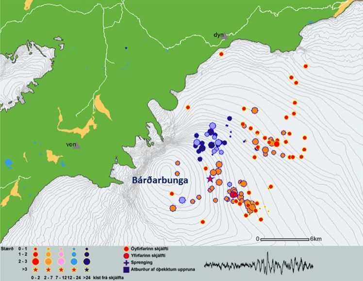
Earthquakes in Bárðarbunga volcano color coded according to time of occurrence.

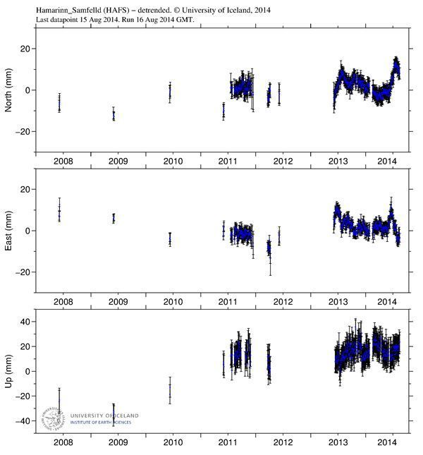
Displacements at the GPS stations at Dyngjuháls and at Hamarinn.
An introduction to Bárðarbunga
There are about 30 known central volcanoes, or volcanic systems, in Iceland. Bárðarbunga, the second highest mountain of Iceland; ca 2000 meters above sea-level, is one of them. The volcano is placed at the north-west of the Vatnajökull ice cap and therefore covered with ice.
The enormous size and nature of Bárðarbunga was not fully recognized until it was observed on a satellite image taken 800 km above earth. A caldera in the volcano's crown, 11 km long on the longer side, is covered with approximately 850 m thick glacial ice. Eruptions related to the central volcano can occur anywhere in the caldera, on the sides of the volcano and also in the fissure swarms to the NA and SW of the volcano, for a distance up to 100 km from the central volcano.
Inevitably, immense eruptions and explosive eruptions are a possibility in the system with imminent threat of ice melting in great magnitude causing a huge jökulhlaup (glacial outburst flood). It is presumed that Jökulsárgljúfur and Ásbyrgi were created in such cataclysmic events in prehistoric times. Large jökulhlaup in Kelduhverfi in the 17th century are believed to be related to volcanic activity in Bárðarbunga.
Over the last seven years seismic activity has been gradually increasing in Bárðarbunga and the fissure swarm north of the volcano. This activity dropped down at the Grímsvötn eruption in May 2011, but soon after, the activity started to gradually increase again. A chapter from a work in progress, the risk assessment of volcanoes in Iceland, is available: Bárðarbunga system (pdf 1.0 Mb).


