
Bárðarbunga 2014 - September events
Seismic and volcanic events 1-30 September
The September observations (pdf 2.22 Mb) of the Bárðarbunga seismic and volcanic events are given here with daily notes, factsheets and/or status reports. Information, day by day, is given in reversed order. In combination, the monthly articles give an overview of events: August, September, October, November, December, January, February, March-April-May and the overview article (list of links).
Calendar
Below is a calendar with a short-cut to each day of this month's events:
Sept.:1-2-3-4-5-6-7-8-9-10-11-12-13-14-15-16-17-18-19-20-21-22-23-24-25-26-27-28-29-30
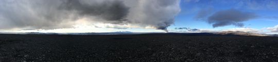 Panoramic view towards the eruptive site in Holuhraun 3rd September 2014. Photo: Richard Yeo.
Updated information
30 September 2014 18:50 - from geoscientist on duty
Since midnight, just over 40 earthquakes have been located at Bárðarbunga and just over 30 in the intrusive dike. Especially in the dike, these are somewhat higher numbers than at the same time yesterday which could stem from the fact that it has been less windy today (as explained yesterday, high winds can blur the detection of small earthquakes). No earthquake has reached 5 in size today; yet three quakes were over M4, all in the northern caldera rim of Bárðarbunga, at 14:53 M4.7 and at 03:06 M4.0 and at 07:57 M4.2. The largest earthquake in the dike was just after midnight, M2.4. According to web cameras, the eruptive activity is of similar intensity as recently.

30 September 2014 11:10 - from the Scientific Advisory Board
Attending: Scientists from Icelandic Met Office and the Institute of Earth Sciences University of Iceland along with representatives from the Icelandic Civil Protection and the Directorate of Health.
From the Scientific Advisory Board:
Notes from the meeting of the Scientific Advisory Board (pdf 0.4 Mb)
From the Icelandic Met Office:
The Aviation Colour Code for Bárðarbunga remains at ‘orange'.
30 September 2014 07:00 - from geoscientist on duty
The largest earthquake since midnight was M4.0 at 03:06, located at the northern caldera rim of Bárðarbunga. Other earthquakes at the northern caldera rim were smaller than 3, of them the largest M2.4 at 00:26. Since midnight 7 earthquakes have occurred in Bárðarbunga and 12 in the northern part of the dyke. Some earthquakes have occurred at Herðubreið and Askja.
Webcam at Vaðalda shows that the volcanic activity in Holuhraun continues with similar intensity as in previous days.
29 September 2014 19:00 - from geoscientist on duty
There are no significant changes in earthquake activity other than the fact that fewer earthquakes have been detected today than in recent days but probably that stems from the high winds that have prevailed (with the consequence that smaller earthquakes go undetected). Since midnight, 30 earthquakes have been located in Bárðarbunga and 15 in the intrusive dike.
The largest earthquake since midnight was M 5.5, located at the southeastern caldera rim. This earthquake is among the largest measured at this central volcano since the onset of these events, 16 August. Up til now, four other quakes have been about 5.5 and one more definately larger, M5.6. All in all, 39 earthquakes have been M 5.0 or more during these events. However, data on the largest earthquakes is still being processed and therefore these numbers might change slightly.

29 September 2014 11:30 - from the Scientific Advisory Board
Attending: Scientists from Icelandic Met Office and the Institute of Earth Sciences University of Iceland along with representatives from the Icelandic Civil Protection and the Directorate of Health.
From the Scientific Advisory Board:
Notes from the meeting of the Scientific Advisory Board (pdf 0.4 Mb)
From the Icelandic Met Office:
The Aviation Colour Code for Bárðarbunga remains at ‘orange'.
29 September 2014 06:58 - from geoscientist on duty
The largest earthquake in Bárðarbunga since midnight was M4.9 and occurred at 03:52 at the northern rim of the caldera. Two other were larger than M3.0; M4.2 at 20:55 and M4.0 at 06:24, both at the northeastern rim of the caldera. In total 22 earthquakes have occurred in Bárðarbunga since midnight, 14 of them at the northern rim of the caldera and 8 in the southern part. Twelve earthquakes have occurred in the dyke, the largest one ca M2.
28 September 2014 19:00 - from geoscientist on duty
No considerable changes can be seen on earthquake activity in northwestern Vatnajökull other than the slow decrease of activity in the northern part of the intrusive dike; this slow decrease has been ongoing during the last few days. There, as before, the great majority of earthquakes occur under northwestern Dyngjujökull and about 15 earthquakes have been located there today. On the other hand, there is no decrease in activity in Bárðarbunga itself; over 50 earthquakes have been located there today, the largest one M 5.2 at 12:34. According to web cameras, the eruption in Holuhraun is still going strong.

28 September 2014 11:00 - joint overview from VÍ and IES
Earthquakes: Seismic activity continues at a similar rate at Bárðarbunga and the nothern part of the dyke intrusion. For the last 24 hours, seven earthquakes exceeding magnitude M3 have occurred at the northern rim of Bárðarbunga. The largest was of magnitude 5.2 at 19:31 yesterday evening.
Volcanic activity: The volcanic activity continues with similar intensity as in previous days.
Displacement: The rate of subsidence of the Bardarbunga caldera is similar to that of previous days. GPS measurements show continuing slow movements.
Water monitoring: No change was detected in water monitoring.
Forecast for gas dispersion
Sunday: Westerly winds. Gas pollution from the volcanic eruption is expected east of the eruption site, over the southern East Fjords. This evening, the pollution will reach north to Hérað and over the northern East Fjords.
Monday: A strong gale (more than 20 m/s) is expected in a wide area tomorrow and heavy rain in the southeast. Gas pollution can be expected north and northwest of the eruption site.
28 September 2014 07:00 - from geoscientist on duty
During the night, no significant changes were seen in earthquake activity. Last night, at 19:32, an M5.2 earthquake occurred at the northern rim of the Bárðarbunga caldera. The largest earthquakes during the night were in the northeastern part of the caldera, at 22:51 M3.5, at 02:04 M3.4 and at 04:44 M4.1. All in all, 16 earthquakes have been detected in Bárðarbunga from midnight, the majority at the northern caldera rim. Only 5 earthquakes have been detected under Dyngjujökull, the largest about M2 in size. According to web cameras the intensity of the eruption is unchanged.

27 September 2014 18:50 - from geoscientist on duty
Earthquake activity under northwestern Vatnajökull is similar to the activity in recent days. Just over 50 earthquakes have been located at Bárðarbunga today, somewhat more than at the same time yesterday. Two earthquakes were over three in size; first at 02:00 M5.1 and then at 08:11 M4.5, both at the northern rim. About 20 earthquakes were located in the dyke under northern Dyngjujökull, as yesterday. One of these reached 2 in size, others were smaller.

27 September 2014 11:00 - a joint overview from IMO and IES
Seismic activity: Seismic activity continues at a similar rate at Bárðarbunga and the northern part of the dyke. For the last 24 hours, six events of M>=3 have occurred, the largest ones at northern Bárðarbunga yesterday afternoon M5.2 and at 02:00 this morning M5.1.
Plume and lava: Visibility in the eruption area is poor due to weather. The plume was observed again on webcam late this morning. Last field observations yesterday indicated that the lava was still flowing northwards, possibly also east according to thermal images but that has not been confirmed by the field team.
Displacements: The subsidence of the Bárðarbunga caldera continues with same rate as before. GPS measurements show continuing slow movements.
Water monitoring: No change was detected in water monitoring.
Forcast for gas dispersion: For the next few days many low pressure areas will pass Iceland. Wind direction will be changing quite frequently. In such conditions gas dispersion forecasting is difficult. The gas should move quite rapidly with the winds, and not accumulate in one specific area.
After the weekend, south and southeast winds are prevalent. The forecast for the weekend:
Saturday: Easterly or variable winds. Pollution mostly expected west of the eruption site.
Sunday: Westerly winds. Pollution mostly expected to southeast and later east of the eruption.
27 September 2014 07:00 - from geoscientist on duty
No significant changes have taken place in the earthquake activity in Bárðarbunga during the night. The largest earthquake since midnight occurred in northern Bárðarbunga about two o‘clock AM, size M 5.0 and therefore somewhat smaller than the earthquake there yesterday afternoon. In all, 17 earthquakes have been detected in Bárðarbunga this night, the majority at the northern caldera rim, but fewer in the intrusive dike under Dyngjujökull, only 8. Eruptive activity could not be monitored on web cameras because of weather conditions; sleet or incipient snow in the area. Visibility was reduced before scientists left the area last night, reporting that the eruption was still going strong.

26 September 2014 19:00 - from geoscientist on duty
About 40 earthquakes have been located at Bárðarbunga today which is a similar number to same time yesterday. Two were over three in size; first at 03:42 M4.1 and then at 16:49 M5.2, both at the northern rim. About 20 earthquakes (bit less than at the same time yesterday) have been located in the dike intrusion, most of them under northern Dyngjujökull. The largest one was a M2.4 at 03:57.


26 September 2014 11:20 - from the Scientific Advisory Board
Attending: Scientists from Icelandic Met Office and the Institute of Earth Sciences University of Iceland along with representatives from the Icelandic Civil Protection and the Directorate of Health. Main points: Volcanic eruption in Holuhraun, air quality and scenarios. The next meeting of the Scientific Advisory Board will be held on Monday 29 September unless deemed necessary.
From the Scientific Advisory Board:
Notes from the meeting of the Scientific Advisory Board (pdf 0.4 Mb)
From the Icelandic Met Office:
The Aviation Colour Code for Bárðarbunga remains at ‘orange'.
26 September 2014 06:48 - from geoscientist on duty
Since midnight ten events have been automatically located in Bárðarbunga and ten in the dyke (beneath northern Dyngjujökull). This is a similar rate as observed yesterday morning. Largest event was around M4 at 03:42 in northern Bárðarbunga. No visible changes in the eruption at Holuhraun from webcams.
25 September 2014 23:10 - a late night photo

25 September 2014 19:00 - from geoscientist on duty
Seismic activity around Bárðarbunga and the dyke intrusion has been persistent today and at similar rates as in recent days. About 40 earthquakes have been manually located in the northern part of the dyke intrusion and about 35 on the caldera rim of Bárðarbunga. Although the vast majority of events around the caldera occur on the northern rim, the ongoing occurrence of M>5 events on the southern rim, like this morning at 05:00, evidences still significant release of seismic moment in this area. It can not be concluded that activity on the southern rim is declining based only on the low number of events. The strongest earthquake in the dyke was M2.3 at 09:55. Six earthquakes on the caldera rim exceeded magnitude 3; the strongest of them were M4.2 at 04:25 (northern rim), M5.2 at 05:00 (south-eastern rim), M4.4 at 05:16 (northern rim) and M5.0 at 16:35 (northern rim).
25 September 2014 11:20 - from the Scientific Advisory Board
Attending: Scientists from Icelandic Met Office and the Institute of Earth Sciences University of Iceland along with representatives from the Icelandic Civil Protection, the Environmental Agency of Iceland and the Directorate of Health. Main points: Volcanic eruption in Holuhraun, air quality and scenarios.
From the Scientific Advisory Board:
Notes from the meeting of the Scientific Advisory Board (pdf 0.4 Mb).
From the Icelandic Met Office:
The Aviation Colour Code for Bárðarbunga remains at ‘orange'.25 September 2014 07:07 - from geoscientist on duty
Since midnight 10 earthquakes have been automatically detected in Bárðarbunga and the same number of events in the dyke under the northern part of Dyngjujökull. At 22:35 last night (24 Sept) an earthquake M4.9 occurred by the northern rim of the Bárðarbunga caldera. Today, 3 earthquakes over magnitude 4 have been located in Bárðarbunga:
At 04:25 M4.2 and 05:16 M4.4 by the northern rim of the caldera.
At 05:00 M5.2 by the southeastern rim.
All the earthquakes in the dyke are around M2 or less. The volcanic activity at the eruption site appears to be stable, based on webcam observations.
24 September 2014 19:10 - from geoscientist on duty
Earthquake activity today (until 19:00) was similar to recent days. Around 35 earthquakes have been manually located around the caldera rim of Bárðarbunga and around 60 events in the northern part of the dyke intrusion. The strongest events were magnitude 5.2 at 08:14 on the northern caldera rim and magnitude 4.0 at 18:41 on the western rim. Eight additional events have exceeded magnitude 3 today. The strongest event in the dyke was magnitude 2.1 at 16:35. According to scientists in the field, and also based on webcam observations, the volcanic activity at the eruption site is stable.
24 September 2014 11:00 - from the Scientific Advisory Board
Attending: Scientists from Icelandic Met Office and the Institute of Earth Sciences University of Iceland along with representatives from the Icelandic Civil Protection and the Environmental Agency of Iceland. Main points: Volcanic eruption in Holuhraun, Air quality, Scenarios.
From the Scientific Advisory Board:
Notes from the meeting of the Scientific Advisory Board (pdf 0.4 Mb).
From the Icelandic Met Office:
The Aviation Colour Code for Bárðarbunga remains at ‘orange'.
24 September 2014 07:00 - from geoscientist on duty
Seismic activity around Bárðarbunga is unchanged compared to recent days. Around 20 earthquakes have been automatically detected on the Bárðarbunga caldera rim, the strongest events were magnitude M3.3 at 00:24 and M3.4 at 04:58. Around 15 earthquakes of magnitude smaller than 2 have been detected in the dyke intrusion, under Dyngjujökull. The volcanic activity at the eruption site appears to be stable, based on webcam observations.

23 September 2014 19:30 - from geoscientist on duty
No changes in seismicity observed in the afternoon. Ten events of M>=3 have been manually checked since midnight. Three of these have M>=4:
at 07:57 Mlw 4.0
at 13:44 Mlw 4.4
at 04:33 Mlw 5.2 all in northern Bárðarbunga.
Between 50 and 60 events have been manually located in Bárðarbunga since midnight and similar number in the dyke. For Bárðarbunga this is similar compared to the average of last three days.
23 September 2014 - earthquake maps for each day - NEW
Specific earthquake maps for northwestern Vatnajökull have received attention. A new feature is available: Earthquake map for each day, and the possibility of running these maps in chronological order.

23 September 2014 11:45 - from the Scientific Advisory Board
Attending: Scientists from Icelandic Met Office and the Institute of Earth Sciences University of Iceland along with representatives from the Icelandic Civil Protection and the Environmental Agency of Iceland. Main points: Volcanic eruption in Holuhraun, Air quality, Scenarios. Notes from the meeting of the Scientific Advisory Board (pdf 0.4 Mb).
From the Icelandic Met Office:
The Aviation Colour Code for Bárðarbunga remains at ‘orange'.23 September 2014 06:45 - from geoscientist on duty
Seismic activity around Bárðarbunga since midnight is unchanged compared to recent days. Around 20 earthquakes have been automatically detected on the Bárðarbunga caldera rim, the strongest events were magnitude M5.2 at 04:33, as well as M3.9 at 01:51 and M3.6 at 01:54, all on the northeastern rim. Around 15 earthquakes of magnitude smaller than 2 have been detected in the dyke intrusion. The volcanic activity at the eruption site appears to be stable, based on webcam observations.
22 September 2014 19:40 - from geoscientist on duty
Around 60 earthquakes larger than magnitude 1 have been detected since midnight, 24 of them are localized in Bárðarbunga. The largest was at 9:50 this morning at the southeastern end of the caldera, magnitude 4.8. The second largest was at 13:36 in the northern part of the caldera; magnitude was 4.7. Six more earthquakes magnitude 3.3-3.8 have ocurred in the caldera today. Microearthquake activity is still ongoing under northern part of Dyngjujökull as well as some microearthquakes that were detected close to Askja and Herðubreið.

22 September 2014 11:30 - from the Scientific Advisory Board
Attending: Scientists from Icelandic Met Office and the Institute of Earth Sciences University of Iceland along with representatives from the Icelandic Civil Protection and the Environmental Agency of Iceland. Main points: Volcanic eruption in Holuhraun, Air quality, Scenarios. Notes from the Meeting of the Scientific Advisory Board (pdf 0.4 Mb).
From the Icelandic Met Office:
The Aviation Colour Code for Bárðarbunga remains at ‘orange'.22 September 2014 06:55 - from geoscientist on duty
Seismic activity has been persistent, but at comparably low levels during the last hours. Since midnight around 10 earthquakes have been automatically detected on the caldera rim of Bárðarbunga. Another around 10 earthquakes were detected in the northern part of the dyke intrusion, all smaller than magnitude 2. Yesterday (21 September), between 19:00 and 24:00, 25 earthquakes were measured: 8 at Bárðarbunga, 13 at the northern end of the dyke and 2 at Herðubreið.
Earthquakes over M3.0 at Barðarbunga between19:00 21 September and 06:00 22 September:
at 19:51 M3.5
at 20:07 M3.7
at 23:08 M3.5
at 00:19 M3.6
at 03:13 M3.7
at 05:28 M3.5
The volcanic activity at the eruption site appears to be stable, based on webcam observations this morning.
21 September 2014 19:00 - from geoscientist on duty
About 85 earthquakes have been detected since midnight, thereof 36 occurred in Bárðarbunga. The largest earthquake was of magnitude 5.5 at the southeastern rim of the caldera at 10:51. A recently mounted GPS station within the caldera showed about 20 cm subsidence at the same time. The second largest earthquake was of magnitude 4.8 at the northern rim of the caldera at 00:57. Two other earthquakes of magnitude between 4 and 5 also occurred there and altogether 7 earthquakes greater than 3 have been detected within the caldera since midnight. About 24 earthquakes were recorded along the northern part of the dyke, all less than magnitude 2. About 18 earthquakes were recorded by Herðubreið and Herðubreiðartögl, all with magnitudes below 1.5.
21 September 2014 11:40 - from the Scientific Advisory Board
Attending: Scientists from Icelandic Met Office and the Institute of Earth Sciences University of Iceland along with representatives from the Icelandic Civil Protection and the Environmental Agency of Iceland. Main points: Volcanic eruption in Holuhraun, Air quality, Scenarios. Notes from the meeting of the Scientific Advisory Board (pdf 0.4 Mb).
From the Icelandic Met Office:
The Aviation Colour Code for Bárðarbunga remains at ‘orange'.21 September 2014 07:00 - from geoscientist on duty
Last evening (19:00-24:00) about 30 earthquakes were detected, 10 at Bárðarbunga, 10 at the northern end of the intrusion and 5 at Herðubreið and Herðubreiðartögl (Töglin). The largest one was at Bárðarbunga at 22:46 3.9 and five more in the same area were over 3 in size.
From midnight til morning (24:00-07:00), automatically detected events are also around 30, most of them around northwestern Vatnajökull. The four largest events were all in northern part of Bárðarbunga caldera:
at 00:57 magnitude 4.8
at 02:21 magnitude 3.8
at 03:05 magnitude 3.7
at 03:30 magnitude 3.4
No visible changes in eruption at Holuhraun from webcams.
20 September 2014 19:00 - from geoscientist on duty
Since midnight about 65 earthquakes have been detected at the Bárðarbunga caldera and similar number at the northern part of the dyke. The largest earthquakes were at the northern rim of the Bárðarbunga caldera at 01:10 with magnitude 5.1 and at 17:11 with magnitude 5.0. Two earthquakes of magnitude 4 and 4.5 occurred at the southern rim of the caldera at 17:04 and 17:05. Seven earthquakes between 3-4 were also detected at the Bárðarbunga caldera. About 15 earthquakes have been detected at Herðubreið and/or Herðubreiðartögl and also a few at Tungnafellsjökull volcano, all less than 2 in magnitude.

20 September 2014 11:30 - from the Scientific Advisory Board
Attending: Scientists from Icelandic Met Office and the Institute of Earth Sciences University of Iceland along with representatives from the Icelandic Civil Protection, the Environmental Agency of Iceland and Directorate of Health. Main points: Volcanic eruption in Holuhraun, Air quality, Scenarios. Notes from the meeting of the Scientific Advisory Board (pdf 0.4 Mb).
From the Icelandic Met Office:
The Aviation Colour Code for Bárðarbunga remains at ‘orange'.20 September 2014 06:50 - from geoscientist on duty
Around 30 earthquakes have been automatically detected around northwestern Vatnajökull since midnight. Of these, around 10 were located on the Bárðarbunga caldera rim and another 15 in the northern end of the dyke intrusion. The strongest event was a magnitude 5.1 on the north-eastern caldera rim at 01:10. All events in the dyke were smaller than magnitude 2. Minor activity was seen at Tungnafellsjökull, Askja and Herðubreið/Herðubreiðartögl. The fissure eruption in Holuhraun appears to be continuing at similar levels as in recent days (based on webcam observations this morning and on the last field report of yesterday evening). Summarizing, no obvious changes are observed, neither in seismic nor volcanic activity.
19 September 2014 18:50 - from geoscientist on duty
About 120 earthquakes have been recorded since midnight. Over 20 are sourced in the Bárðarbunga caldera, six over magnitude 3. The largest were of magnitude 4.7 at 06:45 and magnitude 4.3 at 14:48. Both occurred at the northeastern rim of Bárðarbunga caldera. Over 70 earthquakes have been recorded in the northern part of the dyke, all less than magnitude 2. Few earthquakes have been recorded by Herðubreið and Herðubreiðartögl and none by Askja.

19 September 2014 11:50 - from the Scientific Advisory Board
Attending: Scientists from Icelandic Met Office and the Institute of Earth Sciences University of Iceland along with representatives from the Icelandic Civil Protection, the Environmental Agency of Iceland and Directorate of Health. Main points: Volcanic eruption in Holuhraun, Air quality, Scenarios. Notes from the meeting of the Scientific Advisory Board (pdf 0.4 Mb).
From the Icelandic Met Office:
The Aviation Colour Code for Bárðarbunga remains at ‘orange'.19 September 2014 07:43 - from geoscientist on duty
Since 19:00 yesterday evening only about 10 earthquakes were recorded at the Bárðarbunga caldera and only 3 from midnight until 06:00 this morning. One, with magnitude 4.5, occurred at the northern rim of the caldera at 21:43. Two other earthquakes with magnitude over 3 occurred there at 23:44 and 01:57. At 06:44 this morning an earthquake of magnitude 4.7 occurred at the northeastern rim of the Bárðarbunga caldera. Since midnight about 35 earthquakes have been recorded in the northern part of the dyke, a similar number as the day before. From midnight only 2 earthquakes were recorded by Herðubreið and/or Herðubreiðartögl, all below magnitude 2.
18 September 2014 18:50 - from geoscientist on duty
Nearly 150 earthquakes have been recorded since midnight. About 45 of them occurred in Bárðarbunga, the largest a magnitude 5.3 at the northern rim of Bárðarbunga caldera at 14:22. The GPS station on Bárðarbunga showed a drop of 15 - 20 cm at the time of the earthquake. Two earthquakes occurred with magnitudes between 4 and 5 and four of magnitudes between 3 and 4. Over 50 earthquakes were recorded along the northern part of the dyke, all within magnitude 2. About 30 earthquakes were recorded by Herðubreið and Herðubreiðartögl, all with magnitudes below 2.
18 September 2014 - gas emission rates
Measurements of SO2 emission rates with permanently installed scanning DOAS instruments preliminarily indicate 200-600 kg/s SO2 over the last week of the eruption.
Relating SO2 to other gases measured by FTIR preliminarily indicates 250-700 kg/s CO2, 2-6 kg/s HCl, 3-8 kg/s HF, and <1 kg/s CO.
These emission rates may be underdetections due to measurement conditions. Experiments will be made this week to help us constrain the measurement bias and uncertainty, and these emission rates will likely change. These values are not to be used for further research as they are preliminary and all rights to the data belong to the scientists who are acquiring and interpreting the data.
The participating institutions include: Icelandic Meteorological Office, Chalmers University of Technology, Istituto Nazionale di Geofisica e Vulcanologia, Düsseldorf University of Applied Sciences, University of Palermo, University of Cambridge, and British Geological Survey.
18 September 2014 11:30 - from the Scientific Advisory Board
Attending: Scientists from Icelandic Met Office and the Institute of Earth Sciences University of Iceland along with representatives from the Icelandic Civil Protection, the Environmental Agency of Iceland and Directorate of Health.
Main points: Volcanic eruption in Holuhraun, Air quality, Scenarios.
Notes from the meeting of the Scientific Advisory Board (pdf 0.4 Mb)
From the Icelandic Met Office:
The Aviation Colour Code for Bárðarbunga remains at ‘orange'.18 September 2014 06:55 - from geoscientist on duty
The largest earthquakes recorded in Bardarbunga since 19:00 yesterday. A magnitude 3.2 earthquake occurred at 22:28, M4.1 earthquake at 22:52, M3.5 at 23:35, M4.5 at 03:17 and M3.4 at 06:05. From midnight 13 earthquakes have been detected in Bárðarbunga, about 27 in the northern part of the dyke and around 20 by Herðubreið and Herðubreiðartögl, all below magnitude 2.

17 September 2014 19:00 - from geoscientist on duty
About 115 earthquakes have been located by the automatic system since midnight. Over 20 of them were located in Bárðarbunga and almost 40 in the dike, especially in the northern part under Dyngjujökull. The strongest quake occurred at 18:09:52 UTC in the southeastern part of the Bárðarbunga caldera, of magnitude 5.2. Subsidence in the caldera is about 25 cm since midnight and no abrupt cange was observed during the quake. Other earthquakes are less than or about magnitude 2.
17 September 2014 - measuring subsidence
This morning, the Institute of Earth Sciences measured the subsidence of the glacier surface above Bárðarbunga, see comparison map, the maximum depth was 24.5 m. In broad terms the subsidence seems to be slower than it was 5 - 8 September. The change in volume is possibly comparable to the volume of the lava field extruded at Holuhraun, although such estimate has high uncertainties.
17 September 2014 11:30 - from the Scientific Advisory Board
Attending: Scientists from Icelandic Met Office and the Institute of Earth Sciences University of Iceland along with representatives from the Icelandic Civil Protection, the Environmental Agency of Iceland and Directorate of Health.
Main points: Volcanic eruption, air quality, information, scenarios
Notes from the meeting of the Scientific Advisory Board (pdf 0.4 Mb)
From the Icelandic Met Office:
The Aviation Colour Code for Bárðarbunga remains at ‘orange'.17 September 2014 06:50 - from geoscientist on duty
The largest earthquakes recorded in Bárðarbunga since 19h yesterday occurred in the evening. A magnitude 4.8 earthquake occurred at 20:20 and a 5.4 earthquake at 21:34. From midnight 40 earthquakes have been recorded: 5 in Bárðarbunga, about 15 in the northern part of the dyke and around 20 by Herðubreið and Herðubreiðartögl, all below magnitude 2.
16 September 2014 19:00 - from geoscientist on duty
Nearly 100 earthquakes have been detected in the automatic network since midnight. Just over 20 at Bárðarbunga and over 30 in the intrusion under Dyngjujökull and near the eruptive site. Earthquakes at the northern rim of Bárðarbunga caldera today were at 09:13 M3,4 and at 10:36 M4,8 and at 16:13 M3,7. At the southwestern rim there was an earthquake at 14:47 M5,2. No distinctive subsidence was associated with that earthquake. Some of the GPS stations have shown a change in direction since yesterday. Scientists will take a closer look on that change.

16 September 2014 11:30 - from the Scientific Advisory Board
Attending: Scientists from Icelandic Met Office and the Institute of Earth Sciences University of Iceland along with representatives from the Icelandic Civil Protection, the Environmental Agency of Iceland and Directorate of Health.
Main points: Volcanic eruption, air quality, scenarios
Notes from the meeting of the Scientific Advisory Board (pdf 0.4 Mb)
From the Icelandic Met Office:
The Aviation Colour Code for Bárðarbunga remains at ‘orange'.16 September 2014 10:00 - earthquakes since 16 August 2014
Earthquakes during the first month of events (from 16.09.2014 at 00:00 until 15.09.2014 at 22:20):| all | intrusion | caldera | Kistufell | Askja | HB / HBT | TFJ | Kverkfj. | |
| automatic | ~ 25.000 | - | - | - | - | - | - | - |
| checked | ~ 5.900 | ~ 4.100 | ~ 760 | ~ 120 | ~ 250 | ~ 680 | ~ 70 | ~10 |
| M3.0-3.9 | 186 | 99 | 74 | 6 | 2 | 3 | 1 | 1 |
| M4.0-4.9 | 43 | 7 | 34 | 1 | 1 | 0 | 0 | 0 |
| M>5.0 | 23 | 0 | 23 | 0 | 0 | 0 | 0 | 0 |
- HB/HBT: Herðubreið and Herðubreiðartögl
- TFJ: Tungnafellsjökull
- Kverkfj.: Kverkfjöll
- Kistufell: Cluster north of Bárðarbunga that was active during the first days
- automatic: Automatically detected events in the whole country, number of events outside the Vatnajökull are comparably small in number, contains also false detections. A safe number is “around 20.000 events”.
- checked: Manually revised events.
In "normal" circumstances 10.000-15.000 events occurs per year in Iceland.
16 September 2014 06:45 - from geoscientist on duty
About 50 earthquakes have occurred since midnight. The largest were within magnitude three, sourced at the rim of Bárðarbunga. Eleven earthquakes have been recorded there and nearly 20 in the dyke under Dyngjujökull and under the eruption site.
15 September 2014 19:00 - from geoscientist on duty
Earthquake rates are similar to recent days. Around 120 events have been detected since midnight, the vast majority in the northern part of the intrusion. Some events were located in the old part of the intrusion, i.e. a bit southwest of where the dyke was bending more northerly into Dyngjujökull on 23 August. All events in the intrusion are smaller than magnitude 2.
Occasional earthquakes on the caldera rim of Bárðarbunga. No event exceeded magnitude 2 after the M5.4 this morning at 08:04. Microseismic activity around Dreki (east of Askja) continues at low rates, same at Herðubreiðartögl.
15 September 2014 11:30 - from the Scientific Advisory Board
Scientists from the Icelandic Met Office and the Institute of Earth Sciences and representatives of the Civil Protection in Iceland attend the meetings of the Scientific Advisory Board of the Icelandic Civil Protection. A representative from The Environment Agency of Iceland and Icelandic Directorate of Health was also present.
Conclusions of the Scientific Advisory Board of the Icelandic Civil Protection: Factsheet (pdf 0.3 Mb)
From the Icelandic Met Office:
The Aviation Colour Code for Bárðarbunga remains at ‘orange'.
15 September 2014 06:55 - from geoscientist on duty
No major changes are observed in the seismicity. Between 00:06 and 06:00 23 events were measured near Bárðarbunga and the dyke, of these nine occurred in Bárðarbunga. This rate is similar as two nights ago. The largest events were of magnitude M3.6 at 00:11 and M3.7 at 00:14 at the southern rim. One, M3,8 at the western rim occurred at 02:27. Swarms at Herðubreið, Herðubreiðartögl and Dreki continue (around 15 events in these areas in total). Eruption continues at Holuhraun.
14 September 2014 19:00 - from geoscientist on duty
Earthquake rates remain stable compared to recent days, around 140 events have been detected since midnight (until now 18:50). Most events concentrate in the northernmost part of the dyke intrusion, from the eruption site to about 6 km into Dyngjujökull. Earthquakes in the intrusion hardly exceed magnitude 2. There are still several earthquakes located on the Bárðarbunga caldera rim, one of magnitude around 5 today at 14:06 on the northern rim, five of magnitude 3-4. A small series of events occurred around 17:00 close to Dreki (east of Askja), all events lower than magnitude 1.5.
Stable subsidence is seen on the GPS in the Bárðarbunga caldera, crudely 50-60 cm since midnight. A short step of 10-15 cm lowering might be associated with the 14:06 earthquake.
14 September 2014 12:30 - from the Scientific Advisory Board
Scientists from the Icelandic Met Office and the Institute of Earth Sciences and representatives of the Civil Protection in Iceland attend the meetings of the Scientific Advisory Board of the Icelandic Civil Protection. A representative from The Environment Agency of Iceland was also present.
Conclusions of the Scientific Advisory Board of the Icelandic Civil Protection:
- The eruptive activity at Holuhraun continues at similar intensity. The lava flows at slower rates than it did yesterday. The lava is now spreading more to the sides and there is less visible activity is in the eruptive craters.
- The subsidence of the Bárðarbunga caldera continues and is now up to 23 meters.
- Scientists flying over the area saw new tongues of lava breaking out from the main lava stream towards the east and west. The largest one of these lava tongues stretches towards the east and had become 300 m wide and 2 km long at 18:00 yesterday. An eruption cloud reaches 4 km in height but lowers with distance from the eruption site.
- Seismic activity is similar to what it has been in the past days but earthquakes are starting to go down in numbers and magnitude. Over 60 earthquakes have been detected since midnight. Most of them have been by Bárðarbunga and the dyke under Dyngjujökull. The biggest earthquake, of magnitude 4.0, was detected today at around 07:00 in the south of Bárðarbunga. Three other earthquakes of 3.0 in magnitude or more have been detected today.
- GPS monitoring shows continuing subsidence in Bárðarbunga and insignificant crustal movements north of Vatnajökull around the dyke.
- Air quality in urban areas in the East of Iceland:
-
- High air pollution was detected yesterday in Egilsstaðir and Reyðarfjörður. Forecasts indicate that the gas cloud will blow towards the north in the next 24 hours. High concentrations of sulphuric gases can be expected in Mývatnssveit, Kelduhverfi, Tjörnes, Húsavík, Aðaldalur and Reykjahverfi.
- Instructions:
-
- People who feel discomfort are advised to stay indoors, close their windows, turn up the heat and turn off air conditioning. Use periods of good air quality to ventilate the house. Measurements of air quality can be found on the webpage www.loftgaedi.is. The Meteorological Office issues forecast on its web-page and warnings if conditions change to the worse.
- Instructions from the office of the Chief Epidemiologist and The Environment Agency can be found on their web-sites.
- The Icelandic Met Office will read forecasts for sulphuric gases along with weather news on the national radio and TV.
- The Environment Agency is working on getting more measuring equipment to better monitor the gases coming from the volcanic eruption.
- Information and any questions on air pollution can be sent to The Environment Agency through the email gos@ust.is. The Environment Agency is especially looking for information from people who have been in contact with high concentrations of gas; where they were, at what time it happened, how the gas cloud looked (colour and thickness of the cloud) and how they were affected by it. In the near future, there will be a page on the IMO's webpage for this type of information.
- Air quality at the eruption site:
-
- Gas emissions at the eruption site remain high. As local gas concentrations at the site can be life threatening, people at the eruption site should wear gas masks and gas meters. At the eruption site, local wind anomalies can occur due to thermal convection from the hot lava. This makes the conditions on site extremely dangerous as winds can change suddenly and unpredictably. Scientists in the field have gas meters for their security.
- Three scenarios are considered most likely:
-
- Subsidence of the Bárðarbunga caldera stops and the eruption on Holuhraun declines gradually.
- Large-scale subsidence of the caldera occurs, prolonging or strengthening the eruption on Holuhraun. In this situation, it is likely that the eruptive fissure would lengthen southwards under Dyngjujökull, resulting in a jökulhlaup and an ash-producing eruption. It is also possible that eruptive fissures could develop in another location under the glacier.
- Large-scale subsidence of the caldera occurs, causing an eruption at the edge of the caldera. Such an eruption would melt large quantities of ice, leading to a major jökulhlaup, accompanied by ashfall.
Other scenarios cannot be excluded.
From the Icelandic Met Office:
The Aviation Colour Code for Bárðarbunga remains at ‘orange' and the code for Askja is ‘green'.
14 September 2014 07:10 - from geoscientist on duty
No changes have been observed since midnight. Around 40 events have been detected in Bárðarbunga and the dyke, also a few events near to Herðubreið and Herðubreiðartögl. No major events have occurred since midnight, the largest events were at 01:47 M 3.5 and at 06:54 M 4.0 at the south- and southeastern rim of Bárðarbunga, see map. According to webcam the eruption in Holuhraun still continues on one central crater (Baugur). The vertical displacement of the GPS-instrument on the ice-shelf at Bárðarbunga is around -20 cm from midnight.
13 September 2014 21:10
The advance of the lava has been slow today according to a report from the field, see map (IES).
13 September 2014 19:00 - from geoscientist on duty
Comparatively quiet at the eruptive front, 85 earthquakes have been detected. Most of them, 38, near the northern end of the intrusive dike but 22 in Bárðarbunga, 19 around Herðubreið and Herðubreiðartögl and 6 elsewhere in the country.
The largest earthquake of the day occurred at 07:58 this morning in the nortern part of Bárðarbunga, M4.9, and it was accompanied by ca. 25 cm lowering of the caldera according to the newly installed GPS meter there. In the afternoon, two earthquakes close to M3.5 occurred, both in Bárðarbunga. Other earthquakes have been smaller. According to scientists in the field the activity has diminished and the only crater which is active, is the one named Baugur.

13 September 2014 11:30 - from the Scientific Advisory Board
Scientists from the Icelandic Met Office and the Institute of Earth Sciences and representatives of the Civil Protection in Iceland attend the meetings of the Scientific Advisory Board of the Icelandic Civil Protection. Representative from The Environment Agency of Iceland and the Chief Epidemiologist and the Directorate of Health, were also present.
Conclusions of the Scientific Advisory Board of the Icelandic Civil Protection:
- The eruptive activity at Holuhraun and the the subsidence of the Bárðarbunga caldera floor continues at similar intensity.
- The subsidence of the Bárðarbunga caldera and seismic activity continues the same as the last few days. The GPS station on top of Bárðarbunga shows a subsidence of the caldera around half a meter over the last 24 hours.
- The volcanic eruption in Holuhraun is still ongoing with similar strength as last few days. Lava flows at similar rates as yesterday towards East into Jökulsá á Fjöllum.
- The lava filed was measured yesterday afternoon to be 24,5 square kilometres.
- Accumulated volume of the lava is now estimated to be at least 200 million cubic meters.
- Gas cloud from the eruption drifts to the east. High level of SO2, sulphur dioxide, was measured at Reyðarfjörður last night around 10:00 o'clock. The highest value measured were just under 4000 micrograms per cubic meter. These are the highest values measured in Iceland. High level, 685 micrograms per cubic meter, was also measured in Egilsstaðir.
- Warning was sent via the GSM system to all mobile phones in Fjarðarbyggð.
- Air quality in urban areas in the East of Iceland:
-
- Forecasts indicate that high concentrations of sulphuric gases may be expected in the northern part of the Eastern fjords, Fljótsdalur, Hérað, Jökuldalur, and on Langanes. Forecast indicates that concentration may become higher later today. The Environment Agency will set up new monitoring stations in Akureyri and in South Iceland. Geographical conditions must be considered when estimating air quality.
- Instructions:
-
- People who feel discomfort are advised to stay indoors, close the windows, turn up the heat and turn off air conditioning. Use periods of good air quality to ventilate the house. Measurements of air quality can be found on a map from the Environment Agency. The Icelandic Met Office issues text forecasts and warnings in header if conditions change to the worse.
- Some advise from The Environment Agency can be found on their web-site.
- The Icelandic Met Office will read forecasts for sulphuric gases along with weather news on the national radio and TV.
- The Environment Agency is working on getting more measuring equipment to better monitor the gases coming from the volcanic eruption.
- Air quality at the eruption site:
-
- Gas emissions at the eruption site remain high. As local gas concentrations at the site can be life threatening, people at the eruption site should wear gas masks and gas meters. At the eruption site, local wind anomalies can occur due to thermal convection from the hot lava. This makes the conditions on site extremely dangerous as winds can change suddenly and unpredictably. Scientists in the field carry gas meters for their security.
- Degassing from the volcanic eruption is now estimated to be up to 750 kg/sec.
- Three scenarios are considered most likely:
-
- Subsidence of the Bárðarbunga caldera stops and the eruption on Holuhraun declines gradually.
- Large-scale subsidence of the caldera occurs, prolonging or strengthening the eruption on Holuhraun. In this situation, it is likely that the eruptive fissure would lengthen southwards under Dyngjujökull, resulting in a jökulhlaup and an ash-producing eruption. It is also possible that eruptive fissures could develop in another location under the glacier.
- Large-scale subsidence of the caldera occurs, causing an eruption at the edge of the caldera. Such an eruption would melt large quantities of ice, leading to a major jökulhlaup, accompanied by ashfall.
- Other scenarios cannot be excluded.
From the Icelandic Met Office:
The Aviation Colour Code for Bárðarbunga remains at ‘orange'.
13 September 2014 06:50 - from geoscientist on duty
Since midnight, around 20 earthquakes have been recorded in the north-west region of Vatnajökull. Earthquake locations are similar to recent days: in Bárðarbunga, in the dyke intrusion near to the edge of Dyngjujökull, and occasionally at Herðubreiðartögl. See maps (second image) and weekly overview. At 23:59 (12 Sept.), an earthquake of magnitude 4,7 occurred on the rim of the Bárðarbunga caldera. Web camera views of the eruption site during the night showed volcanic activity at similar levels to yesterday.
12 September 2014 - from the field

The lava is still advancing in the riverbed of Jökulsá á Fjöllum. A narrow flow with heavy current is between the lava and the eastern wall of the riverbed. Occasionally, small steam explosives occur at the edges. The lava advanced 600 m in the past 24 hours. It is still expanding towards north, away from the path of the river. The activity on the fissure is mostly confined to craters Suðri and Baugur.
The gas plume has been continuous and stable; mostly from crater Baugur. Lava fountains from Baugur have been 70-120 m high and this is the only crater still giving rise to fountains.
12 September 2014 19:00 - from geoscientist on duty
Seismicity rates have been comparably low today, but there is still persistent seismic activity in the northern part of the dyke intrusion and around the Bárðarbunga caldera rim. A bit less than 100 events occurred since midnight (now 18:50), most of them automatically detected, some of them found in the continuous data during manual revision. The last earthquake above magnitude 4 occurred at 09:32 this morning (M4.7) on the northern caldera rim. The volcanic activity at the eruption site appears to be stable, based on webcam observations and reports from scientists in the field.

12 September 2014 11:30 - from the Scientific Advisory Board
Scientists from the Icelandic Met Office and the Institute of Earth Sciences and representatives of the Civil Protection in Iceland attend the meetings of the Scientific Advisory Board of the Icelandic Civil Protection. Representative from The Environment Agency of Iceland and the Chief Epidemiologist and the Directorate of Health, were also present.
Conclusions of the Scientific Advisory Board of the Icelandic Civil Protection:
- The eruptive activity at Holuhraun continues at similar intensity. Lava flows at similar rates as yesterday. The lava is flowing towards East into Jökulsá á Fjöllum, slightly narrowing its path. No explosive activity due to the lava and river water interaction has been observed, but steam rises from the lava.
- Scientists flying over the Bárðarbunga area yesterday reported no new changes in the surface.
- Air quality in urban areas in the East of Iceland:
-
- Forecasts indicate that high concentrations of sulphuric gases may be expected in the northern part of the Eastern fjords, Fljótsdalur, Hérað, Jökuldalur, and Vopnafjörður. Forecast indicates that concentration may become highest in Hérað later today. High concentrations could occur in other areas as well. The Environment Agency will set up new monitoring stations in Akureyri and in South Iceland today. Geographical conditions must be considered when estimating air quality. People who feel discomfort are advised to stay indoors, close the windows and turn off air conditioning. Measurements of air quality can be found on the webpage loftgaedi.is. The Meteorological Office issues forecast on its web-page and warnings if conditions change to the worse.
- Instructions from the office of the Chief Epidemiologist and The Environment Agency can be found on their web-sites.
- Air quality at the eruption site:
-
- Gas emissions at the eruption site remain high. As local gas concentrations at the site can be life threatening, people at the eruption site should wear gas masks and gas meters. At the eruption site, local wind anomalies can occur due to thermal convection from the hot lava. This makes the conditions on site extremely dangerous as winds can change suddenly and unpredictably. Scientists in the field carry gas meters for their security.
- Earthquake activity in the caldera of Bárðarbunga remains similar to that of the last days. Epicenters are distributed along the northern and south-eastern caldera fault. Earthquake activity at the dyke tip has decreased. More than 50 events have been detected since midnight. Low frequency tremor has decreased.
- GPS observations:
-
- There are minor crustal movements around the dyke supporting the assumption that the amount of magma flowing into the dyke slightly exceeds the flow of magma erupted to the surface.
- Considering the time period since the beginning of the eruption slow movements towards the Bárðarbunga caldera indicate continuing subsidence of the caldera.
- A new GPS station was installed on top of Bárðarbunga yesterday to monitor the subsidence of the caldera floor.
- Three scenarios are considered most likely:
-
- Subsidence of the Bárðarbunga caldera stops and the eruption on Holuhraun declines gradually.
- Large-scale subsidence of the caldera occurs, prolonging or strengthening the eruption on Holuhraun. In this situation, it is likely that the eruptive fissure would lengthen southwards under Dyngjujökull, resulting in a jökulhlaup and an ash-producing eruption. It is also possible that eruptive fissures could develop in another location under the glacier.
- Large-scale subsidence of the caldera occurs, causing an eruption at the edge of the caldera. Such an eruption would melt large quantities of ice, leading to a major jökulhlaup, accompanied by ashfall.
- Other scenarios cannot be excluded.
From the Icelandic Met Office:
The Aviation Colour Code for Bárðarbunga remains at ‘orange' and the code for Askja is ‘green'.
12 September 2014 06:22 - from geoscientist on duty
No changes have been observed since midnight. Thirty earthquakes have been recorded, mostly located in the dyke under Dyngjujökull and at the eruption site, and at the northern rim of Bárðarbunga. The largest earthquakes are around magnitude 2. A few earthquakes have occurred by Askja, Herðubreiðartögl and Tungnafellsjökull.
Yesterday, between 18:00 and 24:00 was low but persistent activity in the dyke, most events under Dyngjujökull, few around the eruption site. The strongest events in the caldera were M5.2 at 19:57 and M3.1 at 23:33. Occasional events up to M2.8 in Tungnafellsjökull.

11 September 2014 19:00 - from geoscientist on duty
Activity in the Bárðarbunga region is fairly similar to yesterday. Altogether around 150 events have been automatically detected since midnight, most of them in the northern part of the intrusion. None of the events in the dyke has exceeded magnitude 2 until now (18:50). About 40 earthquakes occurred on the caldera rim of Bárðarbunga; the strongest events today were 5.3 at 00:07 and 4.3 at 05:00 and 4.5 at 14:23. Several small events were detected in Tungnafellsjökull and around Herðubreið and Herðubreiðartögl, all smaller than magnitude 3. No significant changes were observed.
11 September 2014 - the extent of the lava

11 September 2014 11:45 - from the Scientific Advisory Board
Scientists from the Icelandic Met Office and the Institute of Earth Sciences and representatives of the Civil Protection in Iceland attend the meetings of the Scientific Advisory Board of the Icelandic Civil Protection. Representative from The Environment Agency of Iceland and the Chief Epidemiologist and the Directorate of Health, were also present.
Conclusions of the Scientific Advisory Board of the Icelandic Civil Protection:
- The eruptive activity at Holuhraun continues at similar intensity. Lava flows at similar rates as yesterday. The lava is flowing towards East but widens slightly towards North. The main flow follows the river bed of Jökulsá á Fjöllum. No explosive activity due to the lava and river water interaction has been observed, but steam rises from the lava.
- Air quality in urban areas in the East of Iceland:
-
- Forecasts indicate that high concentrations of sulphuric gases may be expected in the northern part of the Eastern fjords, Fljótsdalur, Hérað, Jökuldalur, and Vopnafjörður. High concentrations could occur in other areas as well. People who feel discomfort are advised to stay indoors, close the windows and turn off air conditioning. Measurements of air quality can be found on the webpage loftgaedi.is. The Meteorological Office issues warnings if conditions change to the worse.
- Instructions from the office of the Chief Epidemiologist and The Environmental Agency can be found on their web-sites.
- Air quality at the eruption site:
-
- Gas emissions at the eruption site remain high. As local gas concentrations at the site can be life threatening, people at the eruption site should wear gas masks and gas meters. At the eruption site, local wind anomalies can occur due to thermal convection from the hot lava. This makes the conditions on site extremely dangerous as winds can change suddenly and unpredictably.
- Earthquake activity in the caldera of Bárðarbunga remains similar to that of the last days. Epicenters are distributed along the northern and south-eastern caldera fault. An earthquake of M 5.3 occurred at 00:07 h. Earthquake activity at the dyke tip has decreased. More than 30 events have been detected since midnight. Low frequency tremor is similar to what has been observed in the last few days.
- GPS observations show insignificant crustal movements supporting the assumption that the amount of magma flowing into the dyke continues to be similar to the magma erupted to the surface. Considering the time period since the beginning of the eruption slight movements towards the Bárðarbunga caldera indicate continuing subsidence of the caldera.
- Three scenarios are considered most likely:
-
- Subsidence of the Bárðarbunga caldera stops and the eruption on Holuhraun declines gradually.
- Large-scale subsidence of the caldera occurs, prolonging or strengthening the eruption on Holuhraun. In this situation, it is likely that the eruptive fissure would lengthen southwards under Dyngjujökull, resulting in a jökulhlaup and an ash-producing eruption. It is also possible that eruptive fissures could develop in another location under the glacier.
- Large-scale subsidence of the caldera occurs, causing an eruption at the edge of the caldera. Such an eruption would melt large quantities of ice, leading to a major jökulhlaup.
- Other scenarios cannot be excluded.
From the Icelandic Met Office:
The Aviation Colour Code for Bárðarbunga remains at ‘orange' but the code for Askja has been changed to ‘green'.
11 September 2014 06:55 - from geoscientist on duty
Earthquake activity is continuing in Bárðarbunga and in the northern part of the dike intrusion. Around 20 earthquakes were measured this night in the Bárðarbunga area between 00 and 06:30; this is about half the number of events detected during same period yesterday. The largest events occurred just after midnight (00:07:38, M5.3) at the southern caldera rim of Bárðarbunga and around five o'clock (05:00:38 of M4.3 and 05:04:49 of M3.0) at the northern rim of Bárðarbunga. Eruption is still ongoing. Seismic activity at Herðurbreiðartögl is diminishing and has migrated north of Herðubreið where 16 earthquakes were detected (by the automated network) since midnight.
10 September 2014 19:00 - from geoscientist on duty
Around 150 earthquakes have been automatically detected since midnight, most of them in the northern part of the dyke intrusion between the eruption site and south to about 6 km into Dyngjujökull, but around 30 were located in the Bárðarbunga caldera and around 20 in the rest of the country.
All events in the intrusion were smaller than magnitude 2.5. Strongest events in the caldera were magnitude 5.5 at 05:28 this morning on the northern rim, as well as two events of M4.1 at 15:51:00 and M4.8 at 15:51:14, both on the southern rim. The magnitude of the second event might be slightly overestimated as it was biased by the coda of the previous event. It was however clearly stronger than the first event.
Summarizing, the activity remains unchanged. Event rates in the intrusion were slightly lower than in recent days, but activity is persistent.

10 September 2014 11:55 - from the Scientific Advisory Board
Scientists from the Icelandic Met Office and the Institute of Earth Sciences and representatives of the Civil Protection in Iceland attend the meetings of the Scientific Advisory Board of the Icelandic Civil Protection. Representative from The Environment Agency of Iceland and the Chief Epidemiologist and the Directorate of Health, were also present.
Conclusions of the Scientific Advisory Board of the Icelandic Civil Protection:
The eruptive activity at Holuhraun continues at similar intensity. Lava flows to the East at similar rates as yesterday. The lava is flowing in the river bed of Jökulsá á Fjöllum. No explosive activity due to the lava and river water interaction has been observed, but steam rises from the lava.
Air quality in urban areas in East of Iceland:
- Concentrations of SO2, comparable to those measured in the last few days, could increase slightly today in the east due to the direction of the wind. Efforts to increase gas monitoring in inhabited areas are ongoing. Data from The Environmental Agency SO2 monitoring stations in Reyjahlíð, Egilsstaðir and Reyðarfjörður are accessible on the web-site of the institute. Instructions from the office of the Chief Epidemiologist and The Environmental Agency can be found on their web-sites.
Air quality at the eruption site:
- Gas emissions at the eruption site remain high. As local gas concentrations at the site can be life threatening, people at the eruption site should wear gas masks and gas meters.
- Scientists on the site have had to leave the area repeatedly as concentrations of gas reached dangerous levels due to sudden changes in wind conditions.
- At the eruption site, local wind anomalies can occur due to thermal convection from the hot lava. This makes the conditions on site extremely dangerous as winds can change suddenly and unpredictably.
Around 80 earthquakes have been recorded since midnight. The largest two earthquakes, M 5.5 and M 4.9, occurred on the northern rim of Bárðarbunga caldera. Low frequency tremor is similar to what has been observed in the last few days.
GPS observations show insignificant crustal movements supporting the assumption that the amount of magma flowing into the dyke continues to be similar to the magma erupted to the surface.
Three scenarios are still considered most likely:
- Subsidence of the Bárðarbunga caldera stops and the eruption on Holuhraun declines gradually.
- Large-scale subsidence of the caldera occurs, prolonging or strengthening the eruption on Holuhraun. In this situation, it is likely that the eruptive fissure would lengthen southwards under Dyngjujökull, resulting in a jökulhlaup and an ash-producing eruption. It is also possible that eruptive fissures could develop in another location under the glacier.
- Large-scale subsidence of the caldera occurs, causing an eruption at the edge of the caldera. Such an eruption would melt large quantities of ice, leading to a major jökulhlaup.
Other scenarios cannot be excluded.
From the Icelandic Met Office:
The Aviation Colour Code for Bárðarbunga remains at ‘orange' and the code for Askja at ‘yellow'.
Factsheet pdf (0,3 Mb)
10 September 2014 06:40 - from geoscientist on duty
Earthquake activity is continuing in Bárðarbunga and in the northern part of the dike intrusion. Fewer events were detected at Herðubreiðartögl. Nearly 50 earthquakes were measured this night in the Bárðarbunga area between 00 and 06. The largest one occured at 05:28:34 at the northern caldera rim of Bárðarbunga and was of magnitude 4.9 (not manually checked yet; USGS magnitude estimate). Eruption continues north of Dyngjujökull.

9 September 2014 18:00 - from geoscientist on duty
Since this morning, 230 earthquakes have been recorded. The main activity has been in the northern part of the dyke, north of Herðubreið, by Herðubreiðartögl and at the rim of Bárðarbunga. No earthquakes larger than magnitude 3 have been recorded since 01:07.

9 September 2014 12:55 - from the Scientific Advisory Board
- The eruptive activity at Holuhraun continues at similar intensity.
- Air quality in urban areas in East of Iceland may affect people with underlying respiratory problems although others should not experience any significant discomfort.
- Air quality at the eruption site: Gas emissions at the eruption site remain high.
- Around 150 earthquakes have been recorded since midnight. The largest two earthquakes, 3.8 and 5.2 in magnitude, occurred on the northern rim of Bárðarbunga caldera.
- GPS observations show insignificant crustal movements supporting the assumption that the amount of magma flowing into the dyke continues to be similar to the magma erupted to the surface.
- Four scenarios are still considered most likely. Factsheet in pdf (0,3 Mb).
9 September 2014 06:40 - from geoscientist on duty
Earthquake activity is continuing in Bárðarbunga, in the northern part of the dike intrusion and Herðubreiðartögl.
Nearly 50 earthquakes were measured this night in the Bárðarbunga area between 00 and 06. The largest one occured at 01:07 at the northern caldera rim of Bárðarbunga and was of magnitude 5.2 (not manually checked yet; average of USGS and EMSC magnitude estimates, and IMO-alert automatic).
Tremor seems similar through the night, eruption continues.
8 September 2014 19:20 - from geoscientist on duty
The earthquake activity today continues at the northern part of the dyke intrusion. The largest earthquake in the dyke since the end of August occurred at 16:27 today with magnitude 4.5. These are the largest earthquakes located today at the caldera rim:
kl. 06:15 M 4.8
kl. 07:20 M 4.6
kl. 14:48 M 5.0
kl. 17:53 M 4.3
 Impression from the ENE flow front at Jökulsá á Fjöllum. Photo: Morten S. Riishuus.
8 September 2014 - ice surface of Bárðarbunga

8 September 2014 13:20 - from the Scientific Advisory Board
Scientists from the Icelandic Met Office and the Institute of Earth Sciences and representatives of the Civil Protection in Iceland attend the meetings of the Scientific Advisory Board of the Icelandic Civil Protection. Also, representatives from The Environment Agency of Iceland and the Chief Epidemiologist from the Directorate of Health, were present.
Conclusions of the Scientific Advisory Board of the Icelandic Civil Protection:
- The eruptive activity at Holuhraun continues at similar intensity.
-
- The eruption sites are the same as before. Lava flows to the East at similar rates as yesterday. Although the lava is now in contact with the river Jökulsá á Fjöllum, it does not reduce the lava flow rates significantly. No explosive activity due to the lava and river water interaction has been observed, but steam rises from the lava. The extent of the lava is now approximately 19 square km.
- No activity is now detected on the southernmost fissure although small amounts of gas and steam are rising from it.
- Air quality in urban areas in East of Iceland:
-
- Measured concentrations of SO2 in Reyðarfjörður, suggest that people with underling respiratory problems might be affected although others should not experience any significant discomfort.
- Efforts to increase the gas monitoring in inhabited areas are on-going, by The Environment Agency of Iceland.
- If eruptive activity continues at similar rates, the air quality in Eastern part of Iceland will remain similar.
- Air quality at the eruption site:
-
- Gas emissions at the eruption site remain high. As local gas concentrations at the site can be life threatening, people at the eruption site should wear gas masks and gas meters.
- Scientists on site, have had to leave the area as concentrations of gas reached dangerous levels, due to sudden changes in wind conditions.
- At the eruption site, local wind anomalies can occur due to thermal convection from the hot lava. This makes the conditions on site extremely dangerous as winds can change suddenly and unpredictably.
- The seismicity has reduced since yesterday. Around 80 earthquakes have been recorded since midnight. Around 07:20 UTC, a magnitude 4.7 earthquake occurred on the rim of Bárðarbunga caldera. Small but continuous low frequency tremor has been observed for the last few days.
- GPS observations show insignificant crustal movements supporting the assumption that the amount of magma flowing into the dyke continues to be similar to the magma erupted to the surface.
- Four scenarios are still likely:
-
- The migration of magma could stop, resulting in a gradual reduction in seismic activity and no further eruptions.
- The dyke could reach the Earth's surface at different locations outside the glacier. Lava flow and/or explosive activity cannot be excluded.
- The intrusion again reaches the surface under the glacier and possibly leads to a significant eruption. This would most likely produce a flood in Jökulsá á Fjöllum and perhaps explosive, ash-producing activity.
- An eruption in Bárðarbunga. The eruption could cause an outburst flood and possibly an explosive, ash-producing activity. In the event of a subglacial eruption, it is most likely that flooding would affect Jökulsá á Fjöllum. However it is not possible to exclude the following flood paths: Skjálfandafljót, Kaldakvísl, Skaftá and Grímsvötn. Other scenarios cannot be excluded.
From the Icelandic Met Office:
The Aviation Colour Code for Bárðarbunga remains at ‘orange' and the code for Askja at ‘yellow'.
Factsheet in pdf (0.2 Mb)
8 September 2014 06:50 - from geoscientist on duty
The earthquake activity since midnight continues at the northern part of the dyke intrusions and at Bárðarbunga.
Between 30 and 40 events have been located in the area since midnight.
The tremor has been steady since yesterday, no changes and the eruption continues.
7 September 2014 19:00 - from geoscientist on duty
Today, most of the earthquakes have been located in Bárðarbunga caldera, at the eruption site, in Dyngjujökull and at Herðubreiðatögl. The two largest events occurred this morning (M4.6 and M5.4) at 3:27 and 7:07 UTC in Bárðarbunga caldera. We have recorded about 155 earthquakes since this morning and the seismic tremor has been lower than yesterday.
Earth scientists in the field report that the eruptive activity in the northernmost part of the north-fissure has no more lava fountaining, whereas the central craters are the most active like previous days. The new fissure in the south shows no visible activity since this afternoon.
7 September 2014 13:00 - from the Scientific Advisory Board
- The eruptive activity at Holuhraun has not decreased. Magma flow is between 100 and 200 m3/s. The lava advances by about 1 km/day and its area yesterday afternoon was around 16 km2. The eruption sites are the same as before. The eruptive intensity on the southern fissure that opened on Friday is much less than on the northern fissure that has been active since the beginning of the eruption.
- The lava tongue now extends 11 km to the north and has reached the western main branch of Jökulsá á Fjöllum river. However, no explosive activity due to the lava and river water interaction has been observed, but steam rises from the lava. A white eruption cloud rises 3 - 4 km and is directed to the north and northeast.
- Seismicity in the area is similar to yesterday. Around 140 earthquakes have been recorded since midnight. At 03:30 this morning, a magnitude 4.6 earthquake occurred at the rim of the Bárðarbunga caldera. Shortly after 07:00, a magnitude 5.4 earthquake occurred on the rim, one of the largest recorded since the start of the present activity. The amount of magma flow into the dyke seems to be similar to the magma erupting from the fissures.
- The scenarios are the same as before. The factsheet from the meeting (pdf, 0.2 Mb).
7 September 2014 - a new map of the lava

7 September 2014 08:00 - from geoscientist on duty
Earthquake activity continues in Bárðarbunga, in the northern part of the dike intrusion and in Herðubreiðartögl. Total of 70 earthquakes have been detected since midnight, the largest M5,7 at 07:08 in the Bárðarbunga caldera. The lava has reached Jökulsá á Fjöllum. Steaming occurs.
6 September 2014 22:00 - from geoscientist on duty
Earthquake activity today has been in similar places as recent days, in Bárðarbunga caldera, at the eruption site, Dyngjujökull and at Herðubreiðartögl. Two earthquakes 4.4 and 4.3 were recorded in Bárðarbunga caldera in the afternnon, at 14:32 and 18:43 respectively, but this morning at 05:40 a magnitude 5 was measured in a similar location. The total number of recorded earthquakes since midnight is around 170. See map. Earth scientists at the eruption site think that the eruptive activity is similar as yesterday. Seismic tremor has low amplitudes today.
6th September 2014 - the subsidence of the glacier surface

6 September 2014 12:00 - from the Scientific Advisory Board
Scientists from the Icelandic Met Office and the Institute of Earth Sciences and representatives of the Civil Protection in Iceland attend the meetings of the Scientific Advisory Board of the Icelandic Civil Protection.
Conclusions of the Scientific Advisory Board of the Icelandic Civil Protection:
- In the surveillance flight yesterday the ice-surface at Bárðarbunga was measured with the radar system of Isavia's aircraft. The measurements show large changes on the ice-surface. Up to 15 m subsidence has occurred in the centre of the caldera, which corresponds to a volume change of 0.25 km³. The shape of the subsidence area is in accordance with the elevation of the caldera floor having lowered by that amount.
-
- Subsidence of this order has not been observed in Iceland since measurements of crustal movements started around the middle of last century.
- No signs of eruption or increased geothermal activity in the Bárðarbunga caldera are observed.
- The volume of the subsidence in Bárðarbunga is considerable portion of the total volume of the magma dyke.
- The most probable explanation is that this subsidence is related to the recent high seismic activity and subsurface magma flow to the northeast.
- In the surveillance flight yesterday a shallow, wide depression was observed on the surface of Dyngujökull, 10 km from the glacier edge. Another depression 6 km from the Dyngjujökull ice edge, which has been monitored over the last few days has deepened and is now 35 m deep.
-
- It is likely that these depressions are signs of small and short subglacial eruptions.
- The eruptive activity at Holuhraun is the same as yesterday.
-
- Two eruptive fissures are active. The main activity is on the same fissure that has been active since the eruption began. In addition the fissure that opened yesterday morning is still active.
- The lava now extends 10 km ENE and has just under one km to reach Jökulsá á Fjöllum river.
- Seismic activity has decreased since yesterday. Approximately 90 earthquakes have been detected since midnight. One earthquake, of magnitude 5 was located in the Bárðarbunga caldera at 05:40 UTC. 14 earthquakes of magnitudes greater than 5 have been located since 16 of August.
- Deformation changes since yesterday, measured with GPS north of Vatnajökull are small.
- Four scenarios are still likely:
-
- The migration of magma could stop, resulting in a gradual reduction in seismic activity and no further eruptions.
- The dyke could reach the Earth's surface at different locations outside the glacier. Lava flow and/or explosive activity cannot be excluded.
- The intrusion could again reach the surface under the glacier and possibly lead to a significant eruption. This would most likely produce a flood in Jökulsá á Fjöllum and perhaps explosive, ash-producing activity.
- An eruption in Bárðarbunga. The eruption could cause an outburst flood and possibly an explosive, ash-producing activity. In the event of a subglacial eruption, it is most likely that flooding would affect Jökulsá á Fjöllum. However it is not possible to exclude the following flood paths: Skjálfandafljót, Kaldakvísl, Skaftá and Grímsvötn.
- Other scenarios cannot be excluded.
From the Icelandic Met Office:
The Aviation Colour Code for Bárðarbunga remains at ‘orange' and the code for Askja at ‘yellow'.
This factsheet is available as pdf (0,3 Mb).
6 September 2014 - the area and the plume


6 September 2014 06:20 - from geoscientist on duty
Earthquakes have been recorded in similar locations as in recent days: in Bárðarbunga, in the dyke intrusion beneath and north of Dyngjujökull and occasionally at Herðubreiðartögl. At 05:40, an earthquake of magnitude 5 occurred on the rim of the Bárðarbunga caldera. Since midnight, the total number of automatically located earthquakes is around 50. See earthquake maps. Web camera views of the eruption site during the night showed volcanic activity at similar levels to yesterday.
5 September 2014 19:30 - from geoscientist on duty
Since midnight, 270 earthquakes have been detected. The seismic activity is similar to what it has been during the last few days, with most of the activity concentrated at the northern end of the dike. No changes have been detected in the low-frequency tremor since it rose a little bit in the stations next to the eruption at 4 o‘clock this morning.

5 September 2014 - new map
The position this morning of the southern tip of the new fissure (red triangle) and the furthest NW reach of the earlier lava (red circle) are given on a new map (enlarge). The NW stretch of the past few days is also shown. Underneath the map is a photo from this earlier fissure.


5 September 2014 12:20 - from the Scientific Advisory Board
Conclusions of the Scientific Advisory Board of the Icelandic Civil Protection:
- At about 7:00 UTC this morning RÚV reported that new eruptive fissures had opened to the south of the on-going eruption.
- At 8:30, a surveillance flight with scientists from the IMO and University of Iceland observed the following:
-
- Two new eruptive fissures formed south of the previous eruption site in Holuhraun, in a graben, that had formed above the intrusion, about 2 km away from Dyngjujökull.
- The eruptive fire fountains from the new fissures are substantially smaller than in the older fissure. Steam and gas rises in a southeastern direction from the fissure.
- The cauldron in Dyngjujökull seems to have grown deeper since the last observation.
- No changes are visible in Bárðarbunga.
- Substantial amounts of SO2 are still being released into the atmosphere in association with the eruption.
- Conductivity measurements show a slight increase in conductivity in Jökulsá á Fjöllum.
- Some tremor was detected on seismometers shortly after 3:00 UTC last night. It decreased at about 6:00 UTC this morning.
- Considerable activity is in the northern fissure (fissure 1) and the height of the steam cloud is about 15,000 feet.
- There are no indications of the eruption in Holuhraun being in decline. The lava from fissure 1 continues to flow to the east-north-east and has grown in area since yesterday.
- Seismicity in the area is similar to yesterday's activity. About 170 earthquakes were detected since midnight. Two earthquakes of magnitudes 4.4 and 5.3 were detected in the Bárðarbunga caldera region at around midnight UTC.
- GPS displacements have continued to decrease and are now within uncertainty limits.
- Four scenarios are still likely:
-
- The migration of magma could stop, resulting in a gradual reduction in seismic activity and no further eruptions.
- The dike could reach the Earth's surface at different locations outside the glacier. Lava flow and/or explosive activity cannot be excluded.
- The intrusion reaches the surface and another eruption occurs where either the fissure is partly or entirely beneath Dyngjujökull. This would most likely produce a flood in Jökulsá á Fjöllum and perhaps explosive, ash-producing activity.
- An eruption in Bárðarbunga. The eruption could cause an outburst flood and possibly an explosive, ash-producing activity. In the event of a subglacial eruption, it is most likely that flooding would affect Jökulsá á Fjöllum. However it is not possible to exclude the following flood paths: Skjálfandafljót, Kaldakvísl, Skaftá and Grímsvötn.
- Other scenarios cannot be excluded.
From the Icelandic Met Office:
The Aviation Colour Code for Bárðarbunga remains at ‘orange' and the code for Askja at ‘yellow'.
This factsheet is available as pdf (0,3 Mb).

5 September 2014 06:20 - from geoscientist on duty
Earthquakes until 06:00 have been recorded in similar locations as in recent days: in Bárðarbunga, in the dyke intrusion beneath and north of Dyngjujökull and at Herðubreiðartögl.
Two earthquakes of magnitude 4.3 and 5.2 occurred on the rim of the Bárðarbunga caldera. The first earthquake was recorded at 23:33 yesterday and the larger event at 01:19. Since midnight, the total number of automatically located earthquakes is around 100. Web camera views of the eruption site during the night showed volcanic activity at similar levels to yesterday. See map.
4 September 2014 19:00 - from geoscientist on duty
4 September 2014 12:20 - from the Scientific Advisory Board
Conclusions of the Scientific Advisory Board of the Icelandic Civil Protection:
- The intensity of the ongoing eruption in Holuhraun is not declining. Lava is flowing toward ENE and it has been elongated considerably since yesterday. Since this morning, a preliminary estimate of lava field extension is about 10.8 km2.
- Seismic activity is still detected in the northern part of the dyke intrusion, along the eruption site and extending south below Dyngjujökull. Event rates are lower than in recent days, 180 earthquakes have been detected since midnight until noon. Four events larger than M4 have been detected in Bárðarbunga caldera. The largest one (M4.8) occurred last night at 03:09.
- The low frequency tremor seen yesterday disappeared last night but started again this morning, however minor compared to yesterday. The source of the tremor is not certain, however, possible explanation could be magma-water interaction although this interpretation has currently not been confirmed by other observations.
- There are no signs of a subglacial eruption under Dyngjujökull. No obvious changes such as increased water flow or cauldrons on the glacier surface were observed from scientists on board TF-SIF yesterday. Water meters in Jökulsá á Fjöllum do not show any unusual changes in discharge and electric conductivity.
- The GPS time series indicate slower rate of deformation in the last 24 hours. The current deformation pattern north of Vatnajökull still suggests volume increase in the dike. No significant signs of deformation are observed around Bárðarbunga.
- There have been no observations of ash-fall away from the eruption site. Ash production is negligible.
- Sulphur dioxide emission continues. Low-wind speed condition is present in the area at the moment. Based on radar images the eruption cloud from today (composed of steam and volcanic gases) has not drifted far away and is mostly concentrated around the eruption site. Stations measuring SO2 further away from the eruption site are showing concentration below health and safety thresholds. Since this morning, the cloud reaches 6 km of altitude. The volcanic cloud will drift towards south in the coming hours due to wind rotation.
- Four scenarios are likely:
- The migration of magma could stop, resulting in a gradual reduction in seismic activity and no further eruptions.
- The dike could reach the Earth's surface causing another eruption, possibly on a new fissure. Lava flow and (or) explosive activity cannot be excluded.
- The intrusion reaches the surface and another eruption occurs where either the fissure is partly or entirely beneath Dyngjujökull. This would most likely produce a flood in Jökulsá á Fjöllum and perhaps explosive, ash-producing activity.
- An eruption in Bárðarbunga. The eruption could cause an outburst flood and possibly an explosive, ash-producing activity. In the event of a subglacial eruption, it is most likely that flooding would affect Jökulsá á Fjöllum. However it is not possible to exclude the following flood paths: Skjálfandafljót, Kaldakvísl, Skaftá and Grímsvötn.
- Other scenarios cannot be excluded.
From the Icelandic Met Office:
The Aviation Colour Code for Bárðarbunga remains at ‘orange' and the code for Askja at ‘yellow'.
This factsheet is available as pdf (0,3 Mb).

4 September 2014 06:09 - from geoscientist on duty
Activity 00:00-06:00: Tremor measured yesterday stopped around 21:30 yesterday evening and has not been measured since.
Biggest event of the night was magnitude 4.8 earthquake in northern Bárðarbunga. Microearthquake activity continues around Bárðarbunga, in the dike intrusion, around Askja and Herðubreiðartögl.
Around 80 microearthquakes have been located during the night.
The eruption is currently not visible from cameras because of fog. Around 4 o'clock visibility was better and it activity appeared to be the same as before. See earthquake maps: map1 (three different) and map36 (36th week).

3 September 2014 - an image recorded at the field
A recording from the field revealed an interesting feature, similar to a dust devil but most likely composed of volcanic gases and ash particles. Nicarnica Aviation's NicAIR II instrument had been deployed to the field during the fissure eruption at Holuhraun in Iceland. Fred Prata is a lead scientist in this development.
3 September 2014 19:00 - from geoscientist on duty
Persistent seismic activity is still detected in the northern part of the dyke intrusion, between the eruption site and south to about 6 km into Dyngjujökull. Event rates are lower than in recent days. Some events are detected in Bárðarbunga, all of them were smaller than magnitude 4 since the M5.5 event last night at 03:09. The volcanic activity at the fissure in Holuhraun is continuous, no signifiant changes were reported from scientists in the field.
The origin of the increased tremor signal since this morning is still unclear and data is still analysed. However there are no signs of a subglacial eruption under Dyngjujökull. No obvious changes such as increased water flow or cauldrons on the glacier surface were observed from scientists onboard TF-SIF this afternoon. Water meters in Jökulsá á Fjöllum do not show any unusual changes in discharge and electric conductivity. The low frequent tremor signal is still continuing, its strength is variable.

3 September 2014 12:20 - from the Scientific Advisory Board
Scientists from the Icelandic Met Office and the Institute of Earth Sciences and representatives of the Civil Protection in Iceland attend the meetings of the Scientific Advisory Board of the Icelandic Civil Protection.
Conclusions of the Scientific Advisory Board of the Icelandic Civil Protection:
- Earthquake activity continues – around 160 earthquakes have been recorded since midnight today. Seismicity is occurring mostly beneath the northern edge of Dyngjujökull. A magnitude 5.5 earthquake occurred at 03:08 UTC today on the northern side of the Bárðarbunga caldera.
- GPS measurements show that the volume of the dyke intrusion has increased since the beginning of the eruption; this signifies that more magma is entering the dyke than is being erupted.
- Despite no sign of a volume decrease in the dyke, GPS measurements show that the rate of ground deformation has slowed.
- Recent radar images show a 0.5 – 1 km wide depression that has formed both in front of and beneath Dyngjujökull. Signs of the depression extend about 2 km into the ice margin. The increasing thickness of the glacier decreases the visual extent of fracturing associated with the depression, so it is likely that the area extends further beneath Dyngjujökull.
- In light of GPS, radar and seismic results, it is possible that the ongoing eruption could progress southward under Dyngjujökull. This would lead to immediate flooding hazards on the floodplain in front of Dyngjujökull. Consequently, risk assessments for scientists working in the area will be reviewed.
- The volcanic eruption continues on Holuhraun; the main path for lava is to the east-north-east.
- At 08:00 UTC today the total area of the lava flow was estimated at 7.2 km2.
- There have been no observations of ash-fall. Ash production is almost negligible.
- Sulphur dioxide continues to be detected near the eruption site. The eruption cloud is drifting to the north-east from the eruption site.
- Four scenarios are likely:
- The migration of magma could stop, resulting in a gradual reduction in seismic activity and no further eruptions.
- The dyke could reach the Earth's surface causing another eruption, possibly on a new fissure. Lava flow and (or) explosive activity cannot be excluded.
- The intrusion reaches the surface and another eruption occurs where either the fissure is partly or entirely beneath Dyngjujökull. This would most likely produce a flood in Jökulsá á Fjöllum and perhaps explosive, ash-producing activity.
- An eruption in Bárðarbunga. The eruption could cause an outburst flood and possibly an explosive, ash-producing activity. In the event of a subglacial eruption, it is most likely that flooding would affect Jökulsá á Fjöllum. However it is not possible to exclude the following flood paths: Skjálfandafljót, Kaldakvísl, Skaftá and Grímsvötn.
- Other scenarios cannot be excluded.
From the Icelandic Met Office:
The Aviation Colour Code for Bárðarbunga remains at ‘orange' and the code for Askja at ‘yellow'.
This factsheet is available as pdf (0,3 Mb).

3 September 2014 06:24 - from geoscientist on duty
Seismic activity continued at similar rate as yesterday until 03:09 when M5.5 earthquake was measured in northern part of Bárðarbunga.
After that there was increase in activity both in the area under the northern part of Dyngjujökull, south of the current eruption site as well as in Herðubreiðartögl.
The biggest earthquake there was around M3.
Automatically detected events at 06AM are around 130.
From webcam it looks like the eruption continues at similar rate. See earthquake maps

2 September 2014 18:30 - from geoscientist on duty
Since midnight about 400 earthquakes have been detected automatically (700 at the same time yesterday). The main activity is in the dyke mainly in the northern part. Two earthquakes occurred by the rim of the Bárðarbunga caldera, the first one at 11:26 am, M4.7, and the second one at 13:55, M4.3. A few earthquakes were detected by Herðubreiðartögl. See earthquake maps.
2 September 2014 12:00 - from the Scientific Advisory Board
Scientists from the Icelandic Met Office and the Institute of Earth Sciences and representatives of the Civil Protection in Iceland attend the meetings of the Scientific Advisory Board of the Icelandic Civil Protection.
Conclusions of the Scientific Advisory Board of the Icelandic Civil Protection:
- A noticeable decrease in seismicity has occurred during the last 24 hours. The level of activity is approximately half of that during recent days. Since midnight today, around 300 earthquakes have occurred. At the same time yesterday, 01 September, around 500 earthquakes had been detected.
- The rate of deformation at GPS sites closest to the dyke intrusion has decreased. Together with an overnight decrease in seismicity, this implies that magma inflow appears to match magma outflow at the eruption site.
- The eruption has not created any ash-fall. A white plume of steam and gas rises from the eruption on Holuhraun, reaching an elevation of about 4.5 km above sea level. Downwind, a volcanic cloud extends from the eruption site. Yesterday afternoon a white cloud from the eruption extended 60 km to the north-north-east.
- In comparison to yesterday, more sulphur dioxide has been measured in the eruption cloud.
- Sandstorms on the floodplain around the eruption site have contributed fine-grained particles to the eruption cloud. This was seen as a light-brown haze earlier today near to Egilsstaðir.
- The eruptive fissure is about 1.5 km in length, positioned about 4.5 km from the ice margin of Dyngjujökull.
- At 14:00 UTC yesterday, the lava flow was 4.2 km2 in area. At 08:00 UTC the edge had extended 1.5 km to the east-south-east.
- The eruption continues, although there appears to have been a slight decrease in activity compared to yesterday.
- It remains unclear how the situation will develop. Four scenarios are still considered most likely:
- The migration of magma could stop, resulting in a gradual reduction in seismic activity and no further eruptions.
- The dike could reach the Earth's surface causing another eruption, possibly on a new fissure. Lava flow and (or) explosive activity cannot be excluded.
- The intrusion reaches the surface and another eruption occurs where either the fissure is partly or entirely beneath Dyngjujökull. This would most likely produce a flood in Jökulsá á Fjöllum and perhaps explosive, ash-producing activity.
- An eruption in Bárðarbunga. The eruption could cause an outburst flood and possibly an explosive, ash-producing activity. In the event of a subglacial eruption, it is most likely that flooding would affect Jökulsá á Fjöllum. However it is not possible to exclude the following flood paths: Skjálfandafljót, Kaldakvísl, Skaftá and Grímsvötn.
- Other scenarios cannot be excluded.
From the Icelandic Met Office:
The Aviation Colour Code for Bárðarbunga remains at ‘orange' and the code for Askja at ‘yellow'.

2 September 2014 06:50 - from geoscientist on duty
Volcanic activity in Holuhraun continues at steady rate. According to webcam observation there is no visible change in activity since yesterday with effusive lava eruption and fountains.
Seismic activity has been rather quiet this night. Biggest earthquake measured was early in the night, 3.1 in magnitude.
Automatically detected events are around 110 at 6:50AM.
Most of the events, including the biggest one, were located in the northern part of the magma intrusion with some activity extending under the glacier rim.
1 September 2014 19:00 - from geoscientist on duty
Since midnight over 700 earthquakes have been detected automatically which is somewhat fewer than in the past few days. The main activity is in the dyke. Two earthquakes occurred by the northern rim of the Bardarbunga caldera, at 08:58 AM M5.0 and 11:41 AM M5.3. Over 140 earthquakes were detected by Herðubreiðartögl, NE of Askja volcano. A few earthquakes were detected near Askja.
1 September 2014 17:47 - notes from surveillance flight
TF-SIF, the Icelandic Coast Guard's aircraft, did a surveillance flight this afternoon, 13:45 - 16:30. Scientists from the Icelandic Met Office and the Institute of Earth Sciences and a representative of the Civil Protection in Iceland were aboard. Conditions were somewhat cloudy, but visibility was fair in low flight and radar images were retreived at higher altitudes.
Main conclusions:
- The fissure is 1,5 km long. Continuous eruption takes place on a 600-800 m long central section. A single crater has been active at its soutern end, but little or no lava extrudes from it now. Lava plumes rise to a height of a few tens of meters where the activity is greatest, centrally on the fissure.
- The lava stretches 3,5 km ANA from the center of the fissure. It is max 1,6 km wide but narrower further from the craters. The edge of the lava is a tongue 500 m wide. A continuous lava stream flows along the center of the lava field, almost to the edge. The edges are glowing. Apparently, non of the tributaries of river Jökulsá á Fjöllum touches the lava edge.
- The area of the lava is now 4 km2. At 16:00, a rough estimate gives 20-30 million cubic meters of lava. Which means that 5-10 million cubic meters have been added in 18-19 hours. Therefore, average flow is of the order of degree 100 m3/s.
- Two small cauldrons in Dyngjujökull, aligned in the direction of the fissure, seemed unchanged since Friday 29 August.
- Radar revealed no changes in Bárðarbunga nor in the depressions to the southeast of it.
Plume:
- A white plume, with a blue tint below, rose from the eruptive site, and drifted ENE. Maximum height is 15000 feet (4,5 km a.s.l.), ca 10 km from the eruptive site. The plume forms a cloud with very sharp edges at the top and below. The lower edge is in 6500 feet (2.0 km a.s.l.). This cloud reaches at least 60 km NNE. The southern edge of it is over Báruvatn, Laugarvalladalur and the southernmost part of lake Lögurinn. The cloud is about 10 km wide, 30 km northeast of the eruptive site. A dustcloud, originating from the Flæður, lies below the plume and its cloud. It didn‘t seem that any ash came from the cloud. The white colour of the plume does not suggest any ash. Plume photos with explanations: Halldór Björnsson, Pálmi Erlendsson, Emmanuel Pagneux (pdf 1.8 Mb).

1 September 2014 12:23 - from the Scientific Advisory Board
Scientists from the Icelandic Met Office and the Institute of Earth Sciences and representatives of the Civil Protection in Iceland attend the meetings of the Scientific Advisory Board of the Icelandic Civil Protection. This factsheet is available as pdf (0,3 Mb).
Conclusions of the Scientific Advisory Board of the Icelandic Civil Protection:
- Scientists from the Icelandic Met Office and the Institute of Earth Sciences and representatives of the Civil Protection in Iceland attend the meetings of the Scientific Advisory Board of the Icelandic Civil Protection.
- Conclusions of the Scientific Advisory Board of the Icelandic Civil Protection:
- The lava eruption on Holuhraun continues. Lava flows northward from the eruption site.
- At 13:00 UTC today, an overflight will be made over Holuhraun and north-west Vatnajökull with scientists from the Icelandic Meteorological Office and the University of Iceland, together with a representative from the Icelandic Civil Protection. Observations from this flight will be reported in later briefings.
- At 20:00 UTC yesterday, the lava extended over a 3-km-area. This corresponds to a magma discharge of 300 to 500 cubic metres per second. From observations yesterday evening, the volume of erupted lava is between 16 and 25 million cubic metres.
- The eruption has not created any ash-fall.
- Gas and steam rises to a couple of hundred metres above the eruption site, extending up to 1,200 m downwind.
- In connection with the FUTUREVOLC project, a gas monitoring station has been set-up near to the eruption site. Gas measurements indicate a high level of sulphur dioxide. People could be exposed to highly dangerous gas levels close to the eruption. It is essential that those visiting the eruption site are equipped with gas sensors and gas masks.
- According to the latest GPS observations, horizontal ground movements continue in response to the dyke intrusion. There is no clear sign of a pressure decrease in the dyke intrusion in connection with the ongoing eruption, although there are irregularities in GPS displacements at nearby stations. The northern extent of the dyke intrusion has not changed to any great extent.
- When Sunday's eruption began earthquake activity decreased somewhat, although seismicity remains high, with over 500 earthquakes detected since midnight today. Most of the seismicity is occurring on the northern end of the dyke intrusion, covering a 15-km-long region that extends partly beneath Dyngjujökull and north of the ice margin.
- At 08:58 UTC today, a magnitude 5.0 earthquake was recorded on the Bárðarbunga caldera, and another of magnitude 5.2 at 11:41 UTC in the same region.
- It remains unclear how the situation will develop. Four scenarios are still considered most likely:
- The migration of magma could stop, resulting in a gradual reduction in seismic activity and no further eruptions.
- The dike could reach the Earth's surface causing another eruption, possibly on a new fissure. Lava flow and (or) explosive activity cannot be excluded.
- The intrusion reaches the surface and another eruption occurs where either the fissure is partly or entirely beneath Dyngjujökull. This would most likely produce a flood in Jökulsá á Fjöllum and perhaps explosive, ash-producing activity.
- An eruption in Bárðarbunga. The eruption could cause an outburst flood and possibly an explosive, ash-producing activity. In the event of a subglacial eruption, it is most likely that flooding would affect Jökulsá á Fjöllum. However it is not possible to exclude the following flood paths: Skjálfandafljót, Kaldakvísl, Skaftá and Grímsvötn.
- Other scenarios cannot be excluded.
From the Icelandic Met Office:
The Aviation Colour Code for Bárðarbunga remains at ‘orange' and the code for Askja at ‘yellow'.
1 September 2014 06:50 - from geoscientist on duty
The activity around Bárðarbunga from midnight until 06:50 1st September:
Volcanic activity in Holuhraun:
The fissure eruption is continuing at a stable level. No explosive activity is observed, the eruption remains an effusive lava eruption. Visual observation by webcam and low level volcanic tremor on seismometers do not show any obvious changes since evening. More detailled information will soon follow from scientists in the field.
Seismic activity:
Around 250 earthquakes have been automatically detected until now. Most of them are located in the northern part of the magma intrusion, between the eruption site and south to about 10 km into Dynjujökull. Strongest events were up to around magnitude 2. The rate of events has decreased as a result of pressure release due to the eruption, but there is still ongoing continuous seismicity.
Several events have occurred around the Bárðarbunga caldera rim, strongest events were M4.2 at 03:09 on the southern rim and M4.5 at 04:59 on the northern rim. See maps.
In the broader Askja region, most events were located at Herðubreiðartögl, the strongest event there was M2.9 at 02:56. This area is a quite common place for seismic activity, the activity now is not necessarily caused by increased stress due to the intrusion (the tip of the intrusion is about 25 km SW of this cluster). Askja volcano itself was seismically quiet last night.

16 - 31 August 2014
Observations in August, since the onset of events, are found in another comparable article.


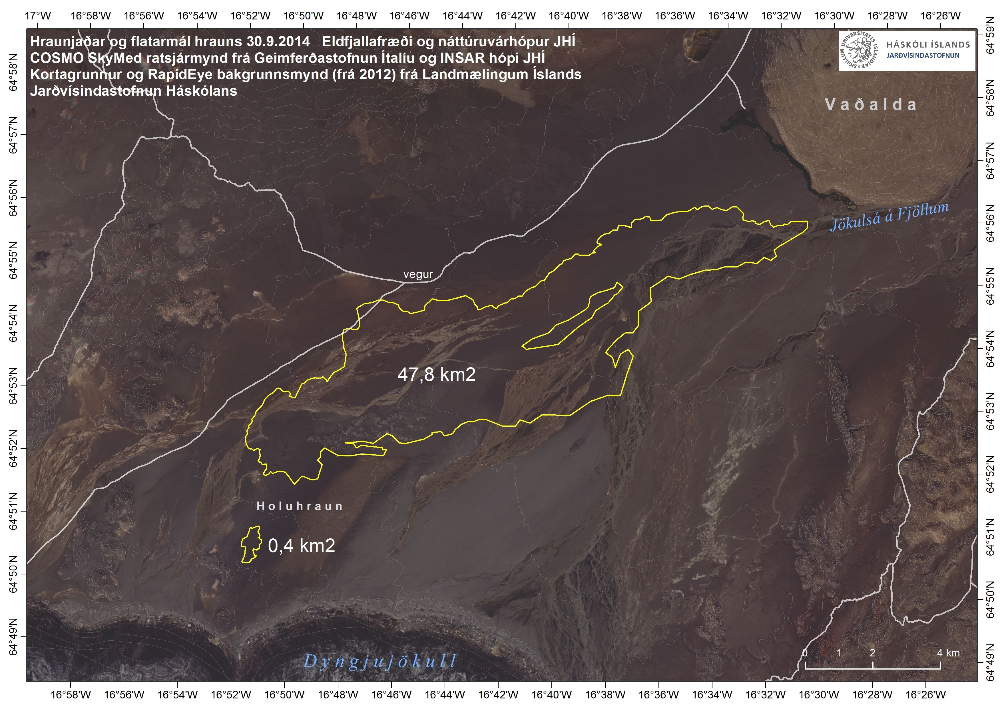
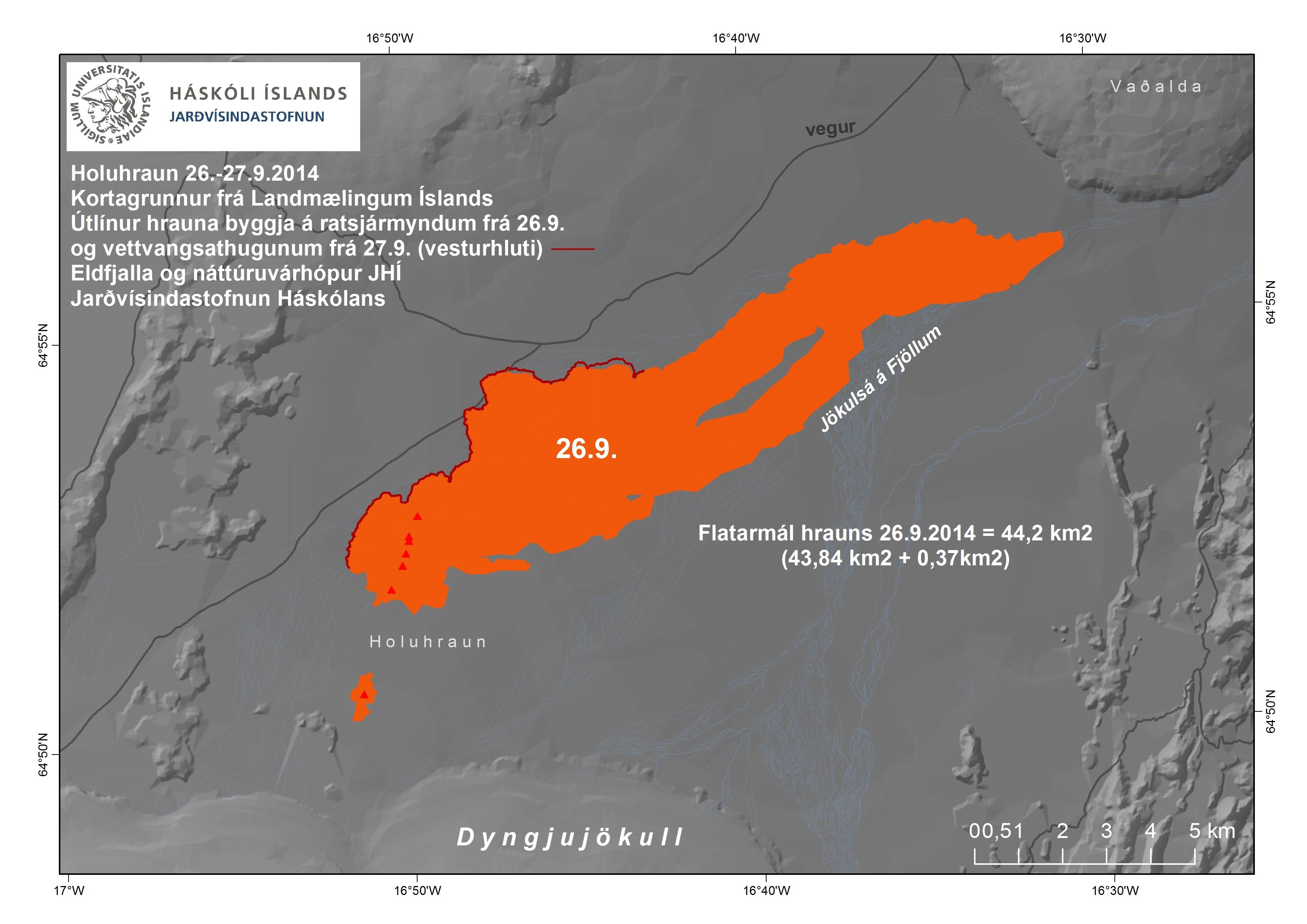
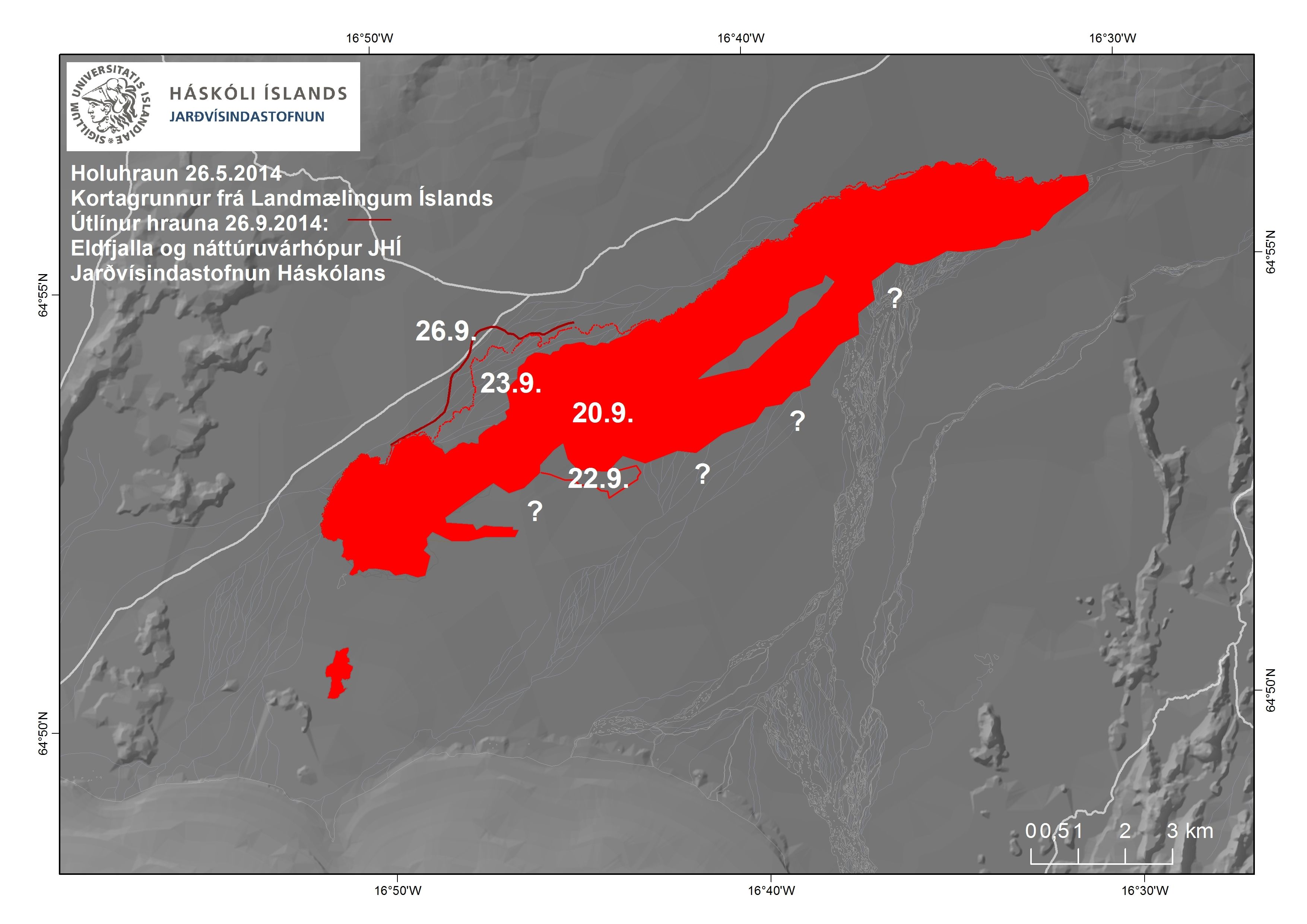
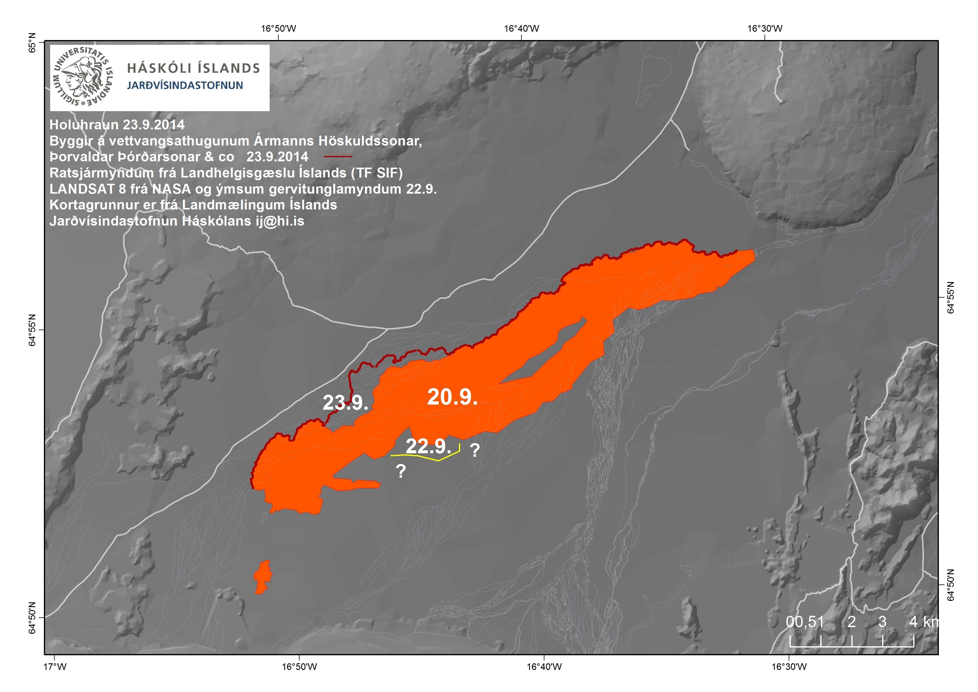
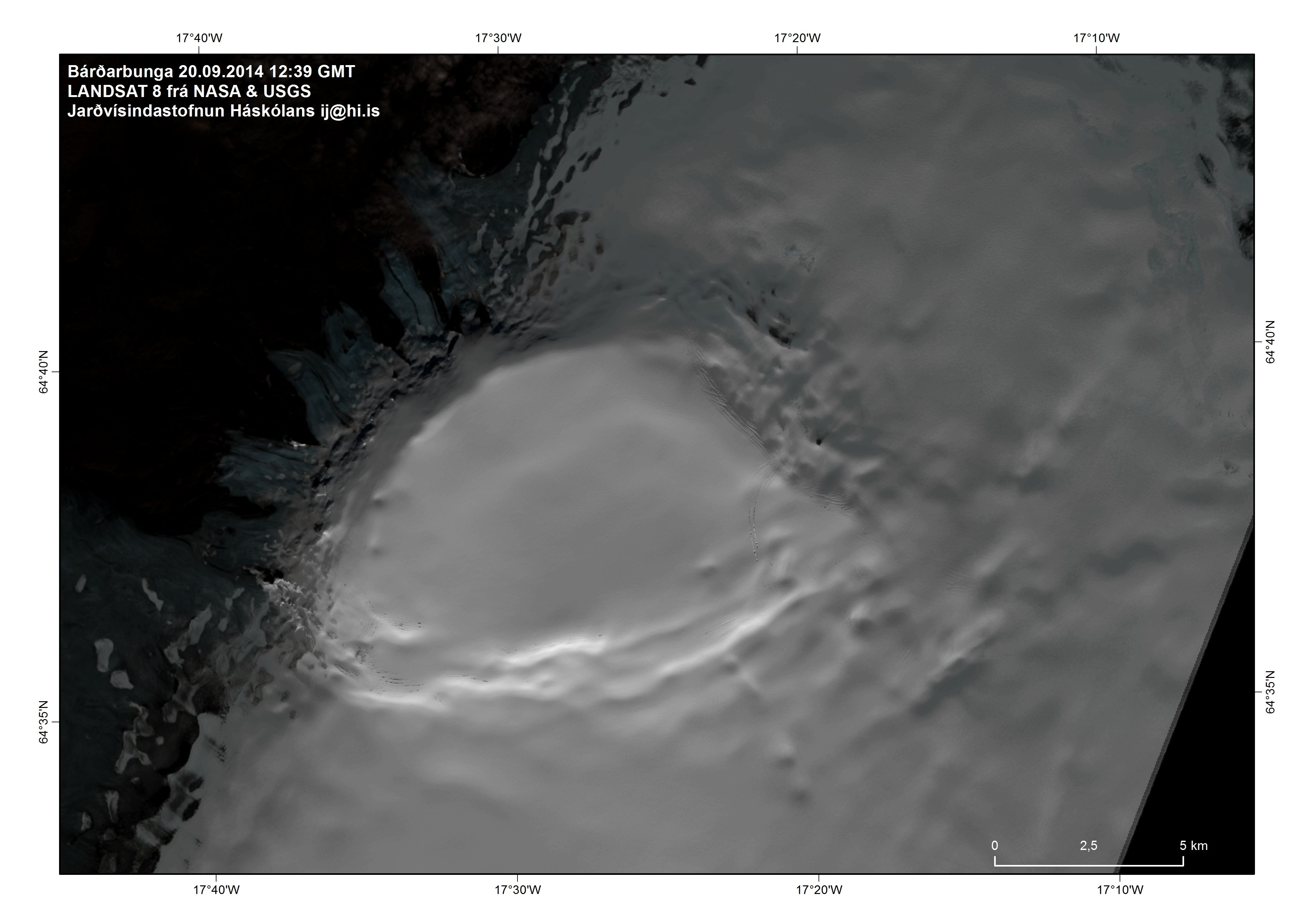
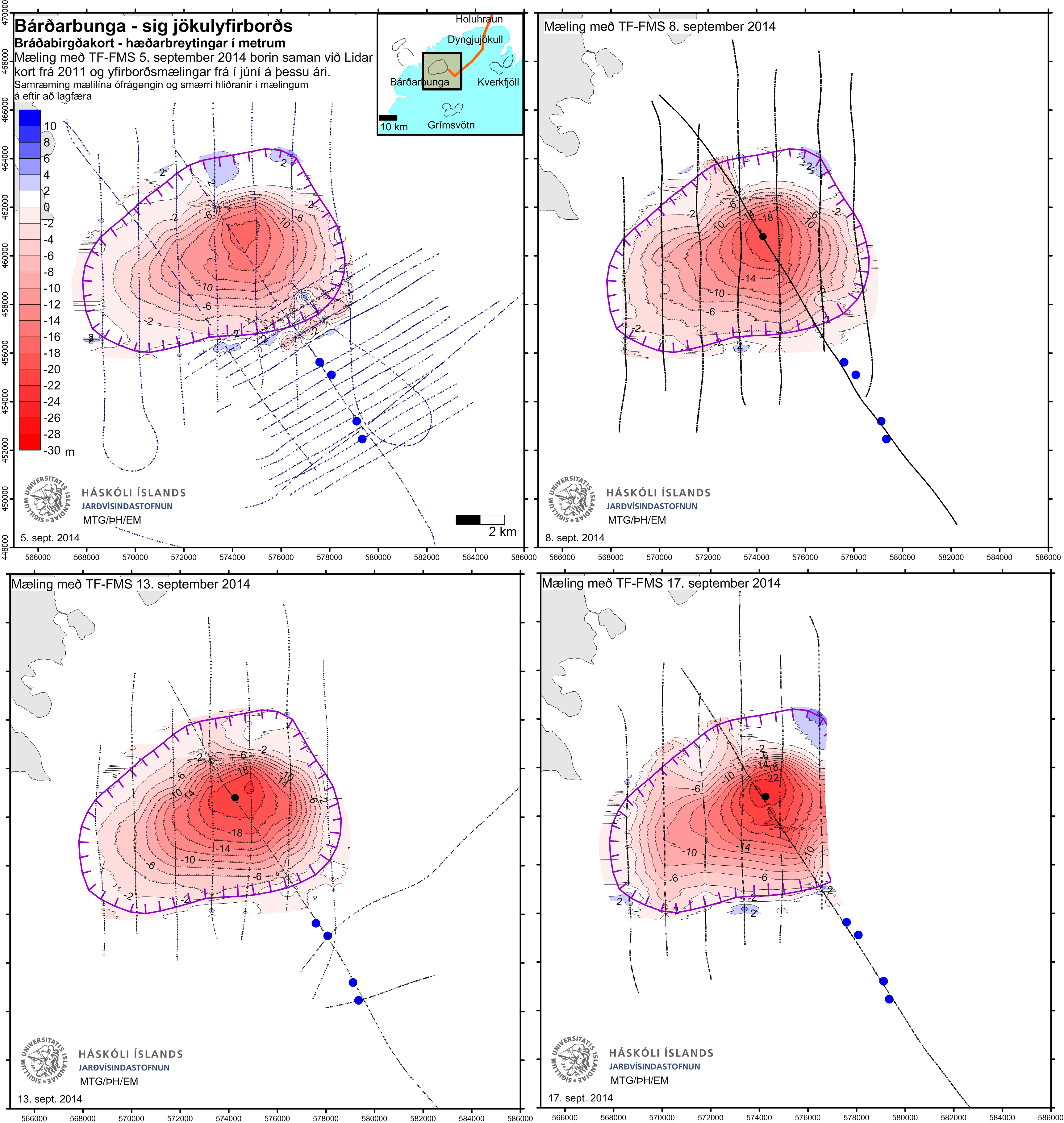
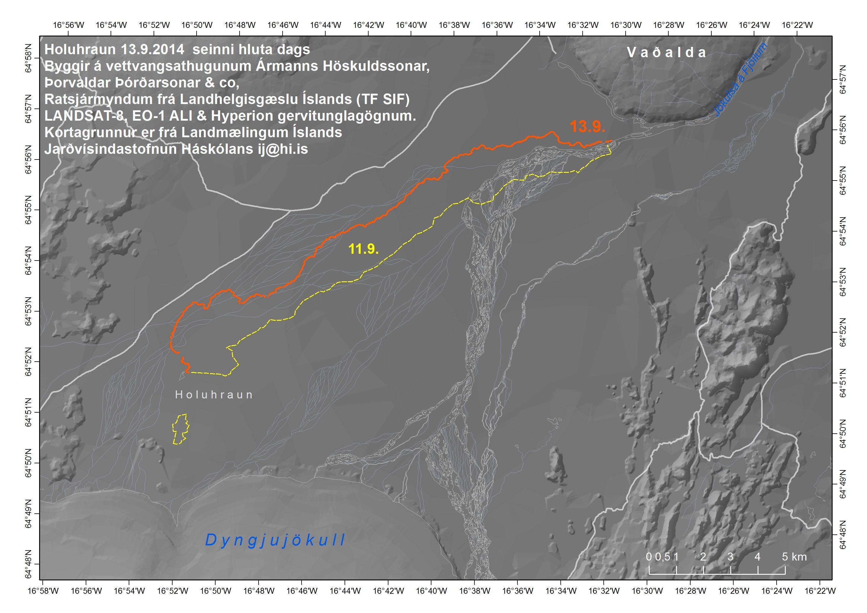
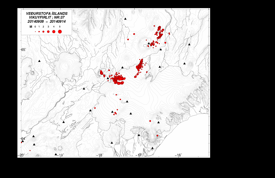
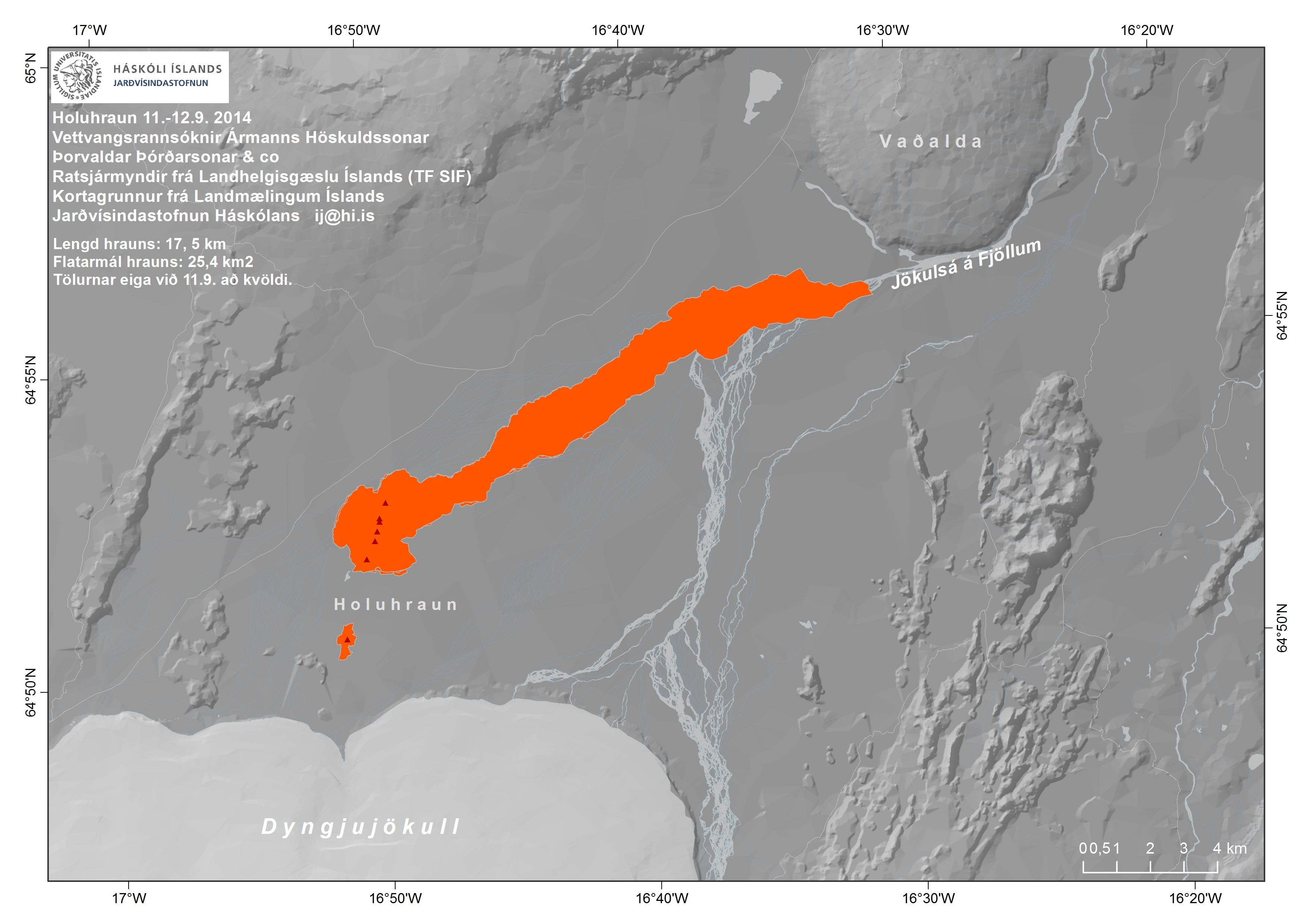
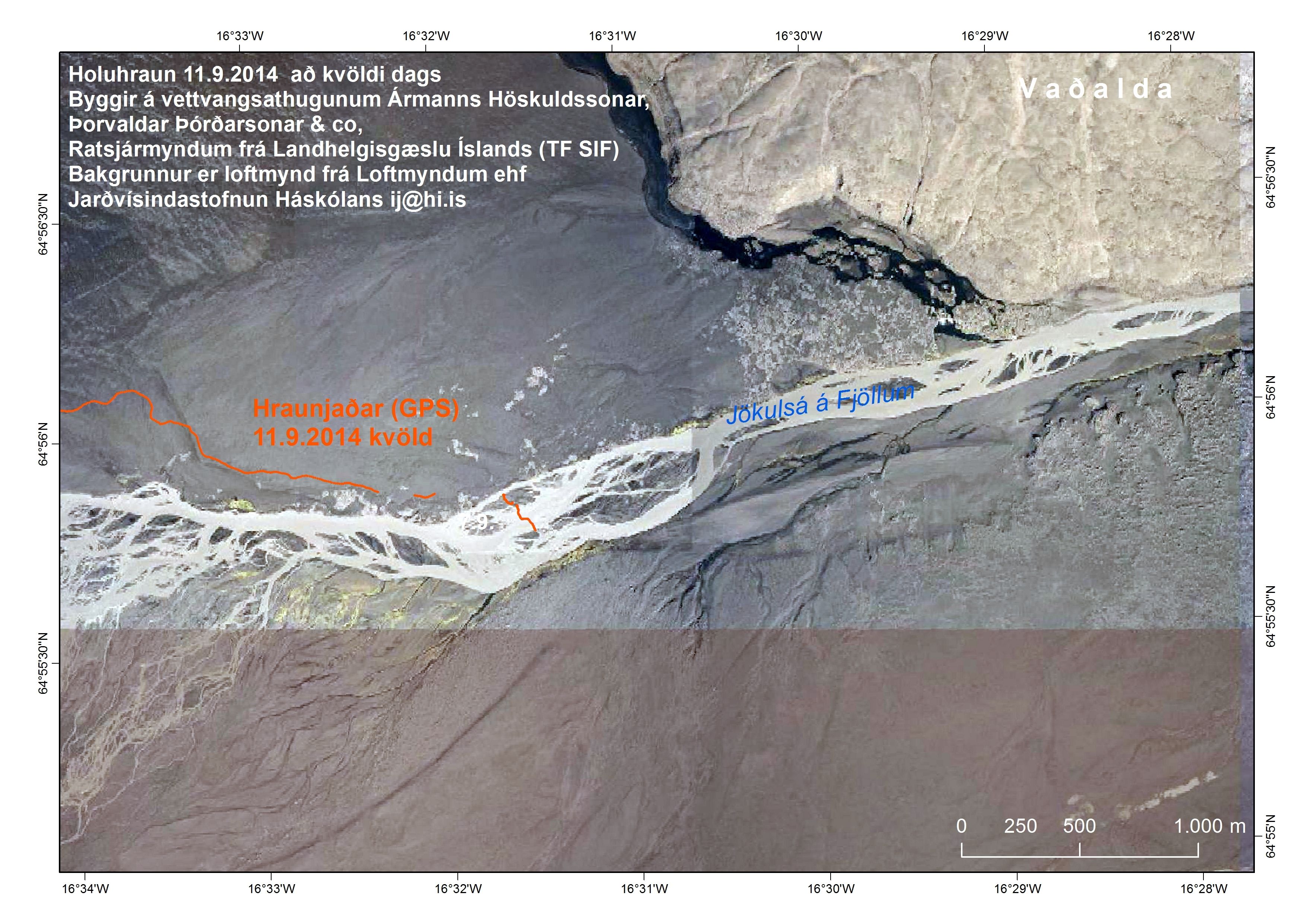
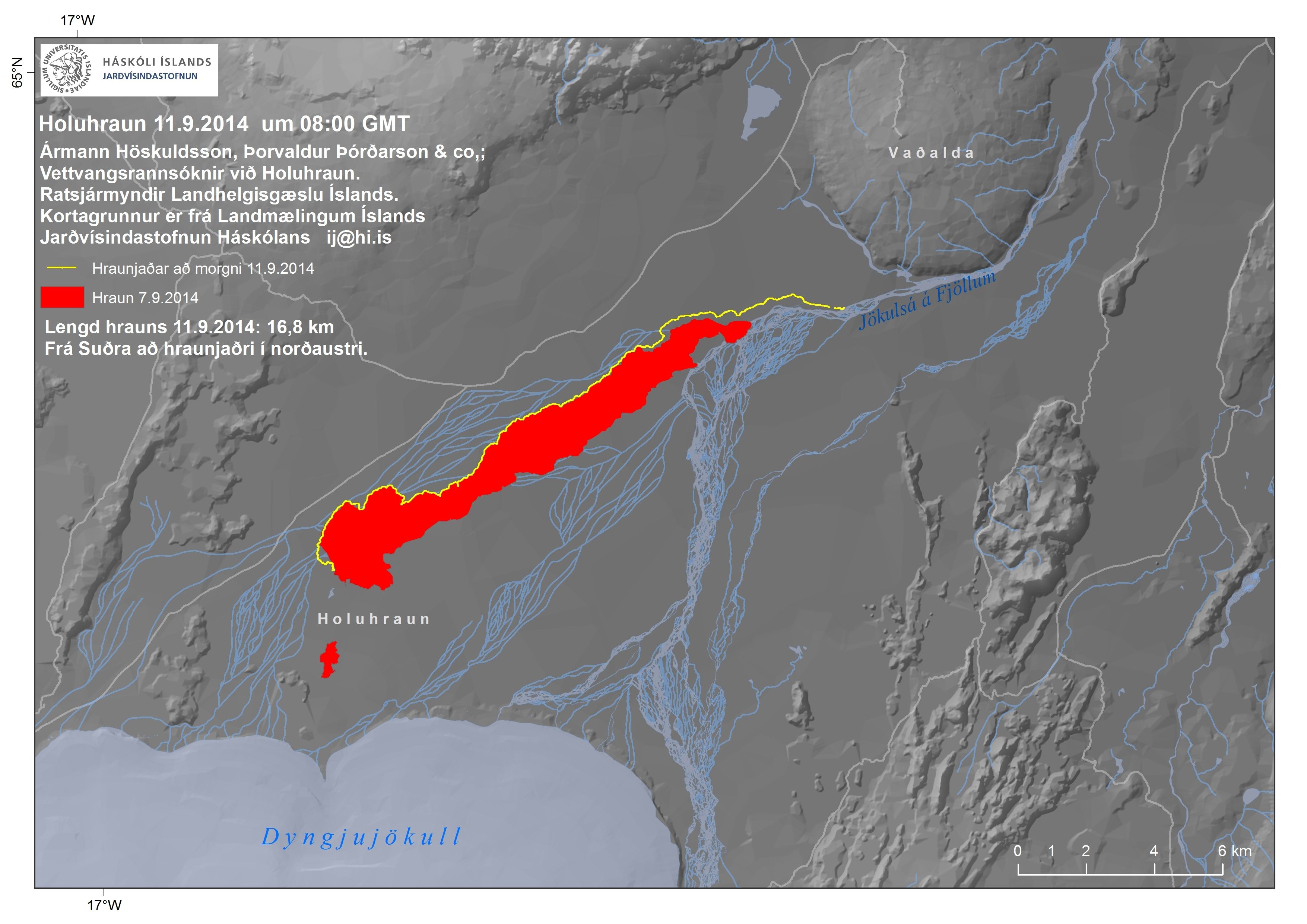
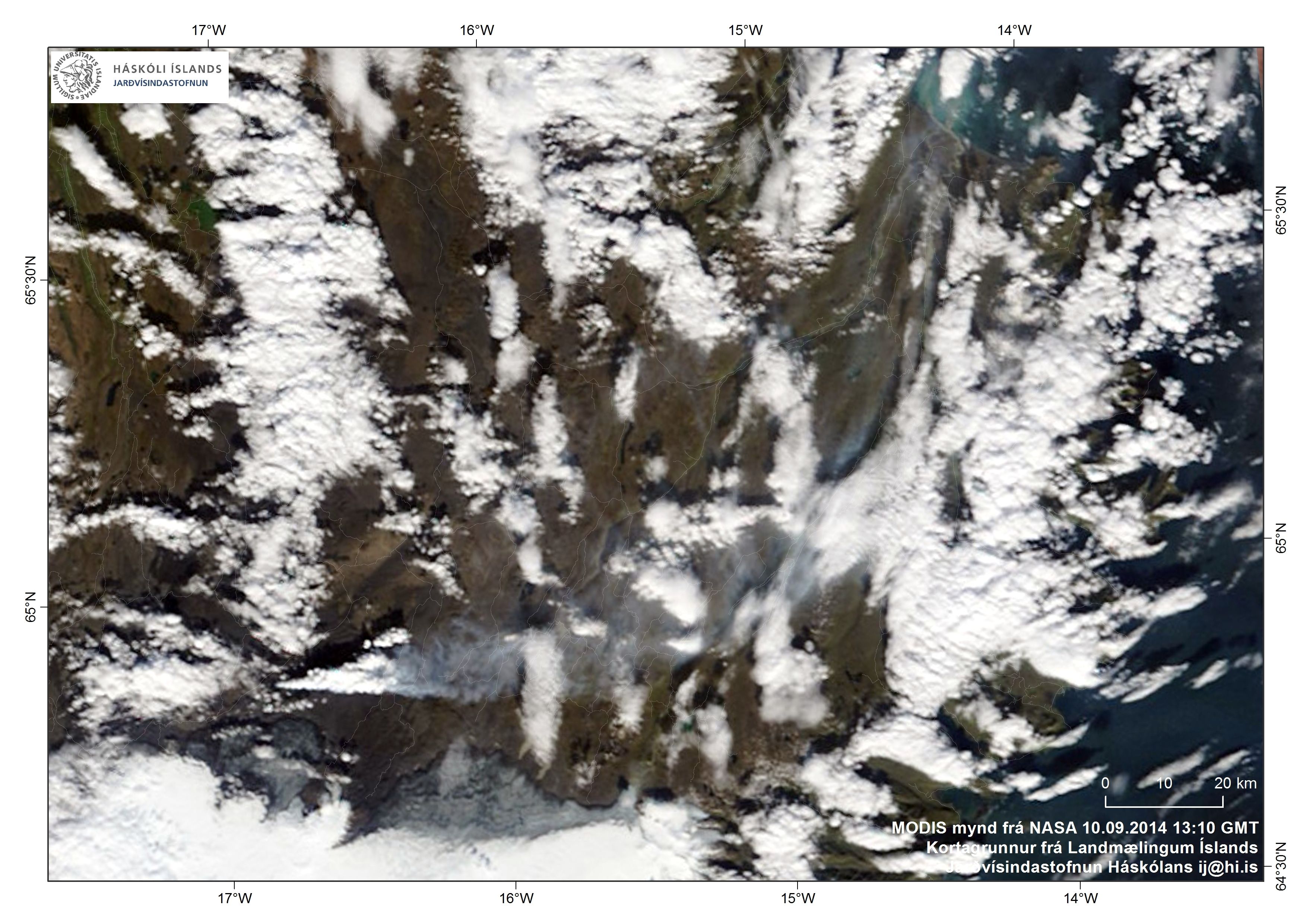
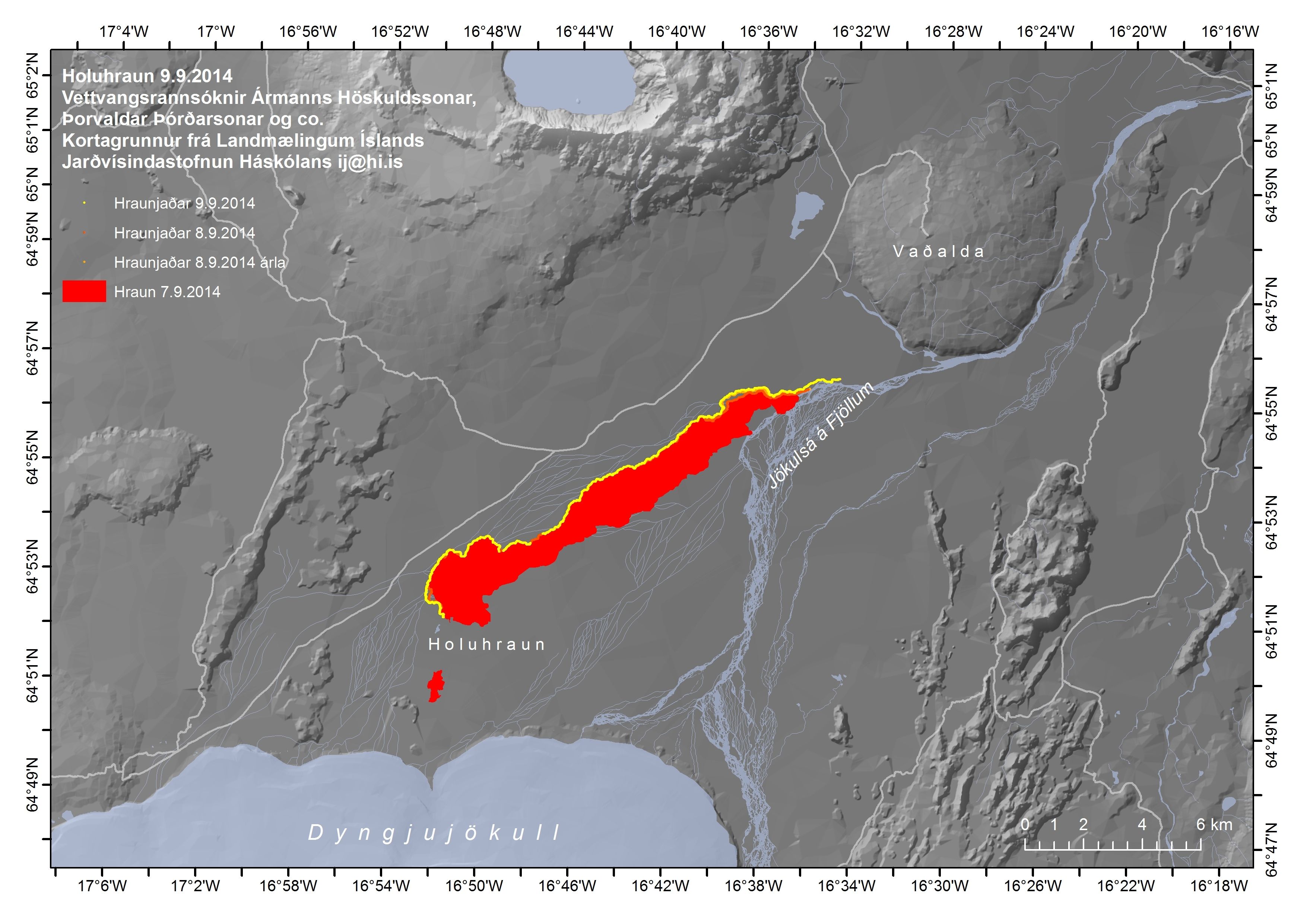
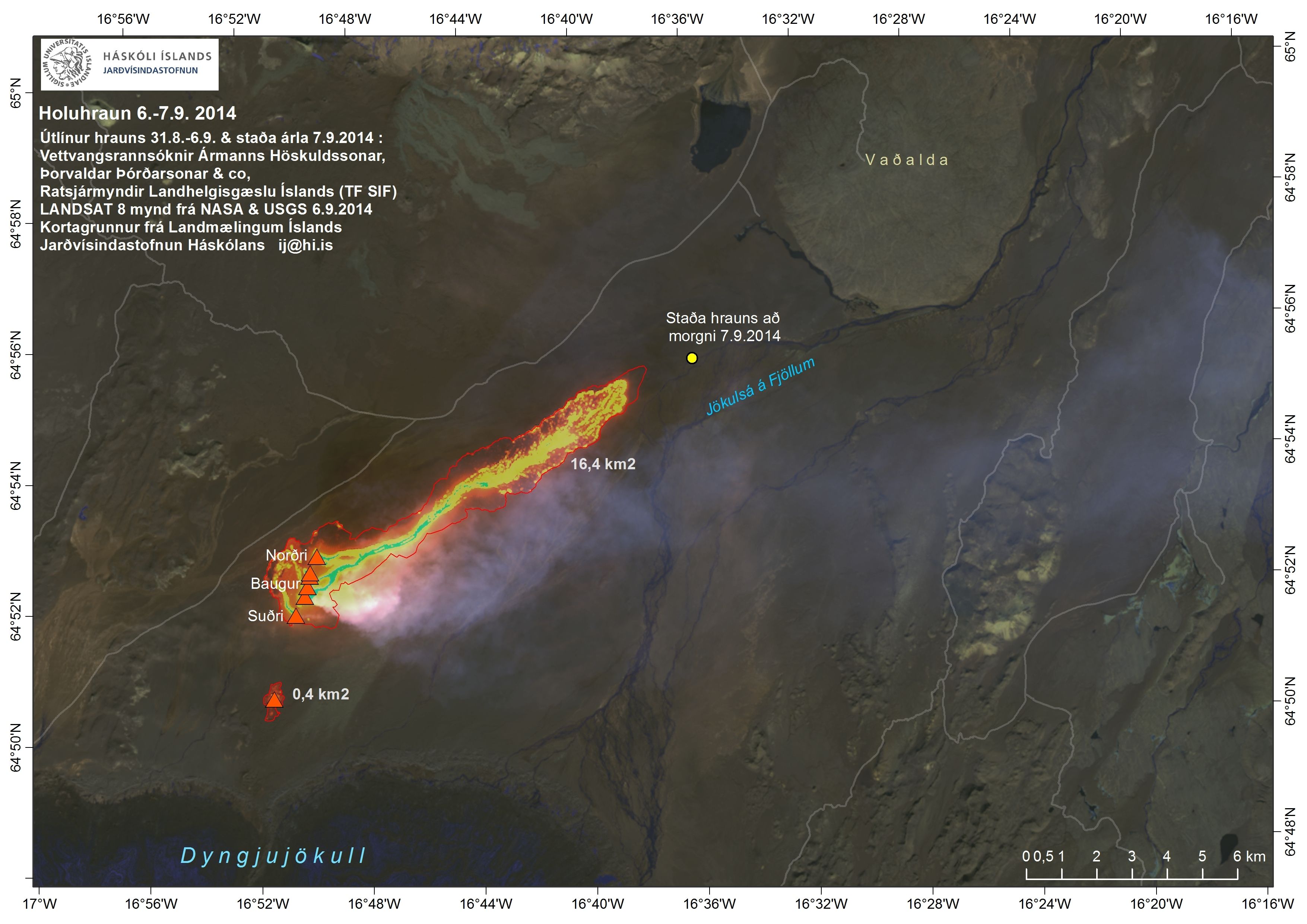
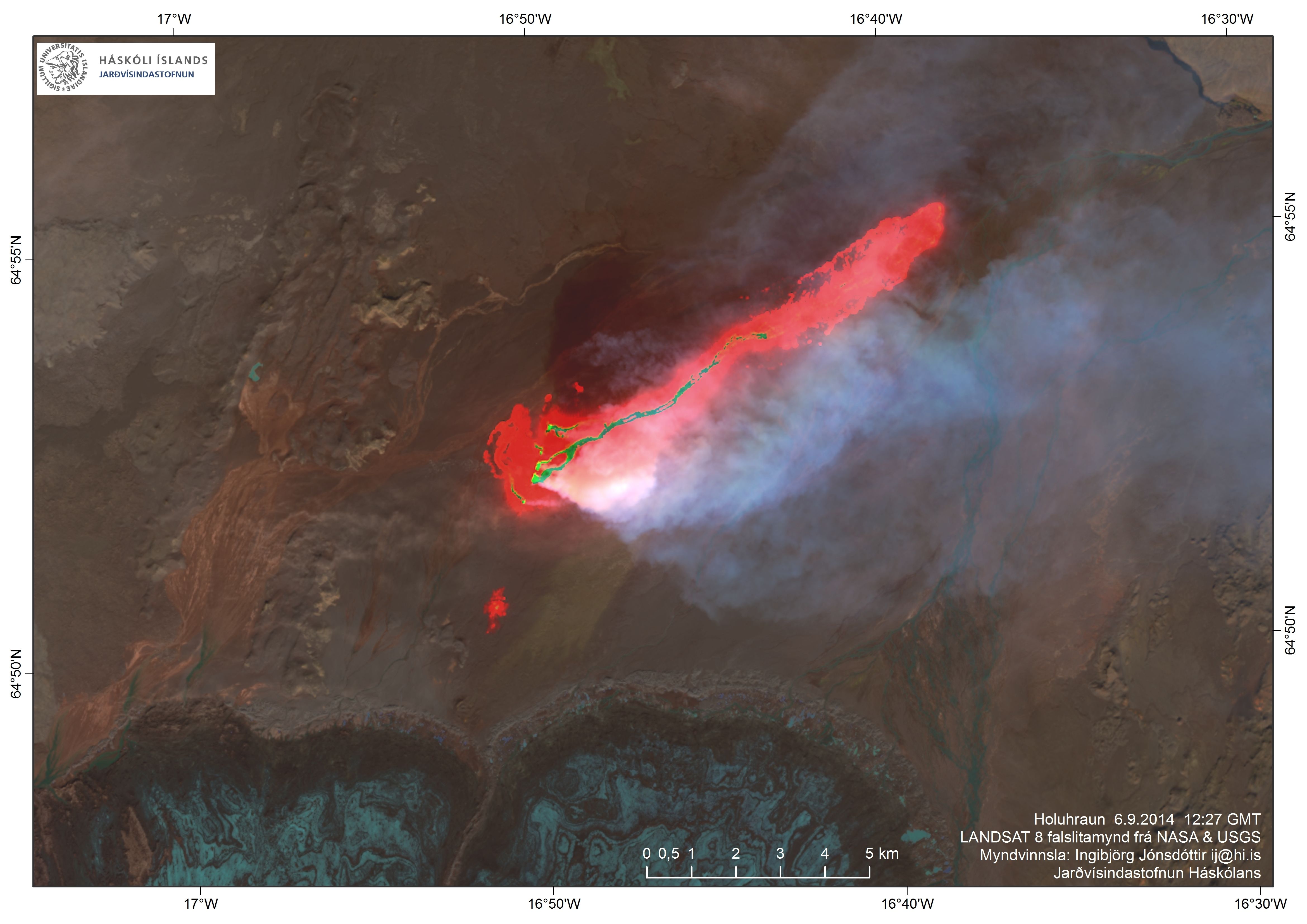
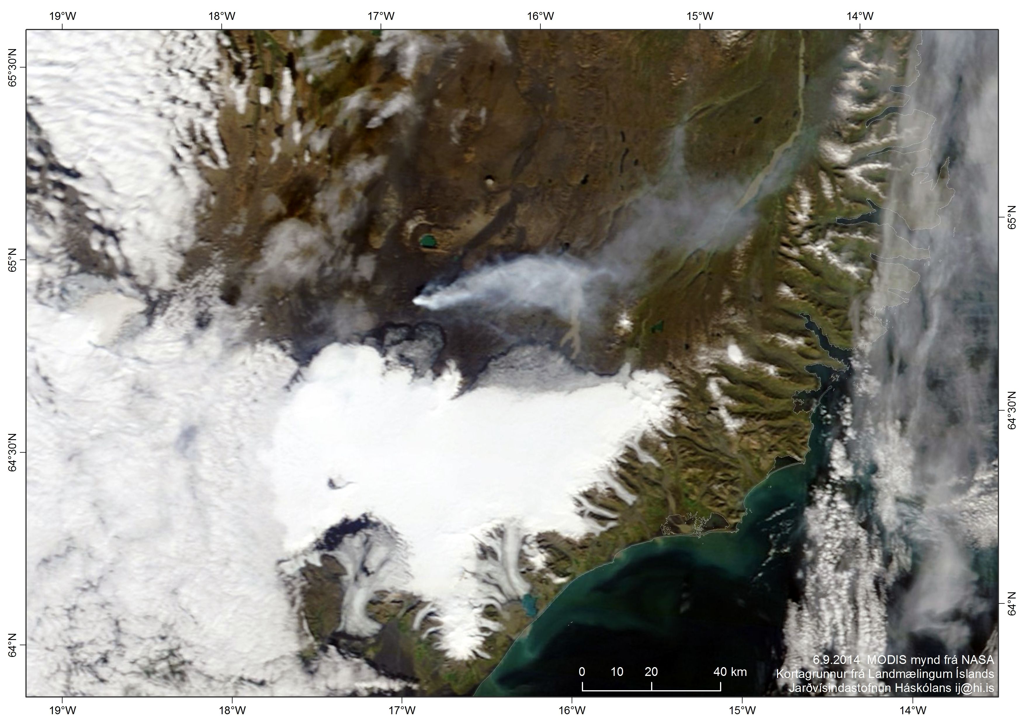
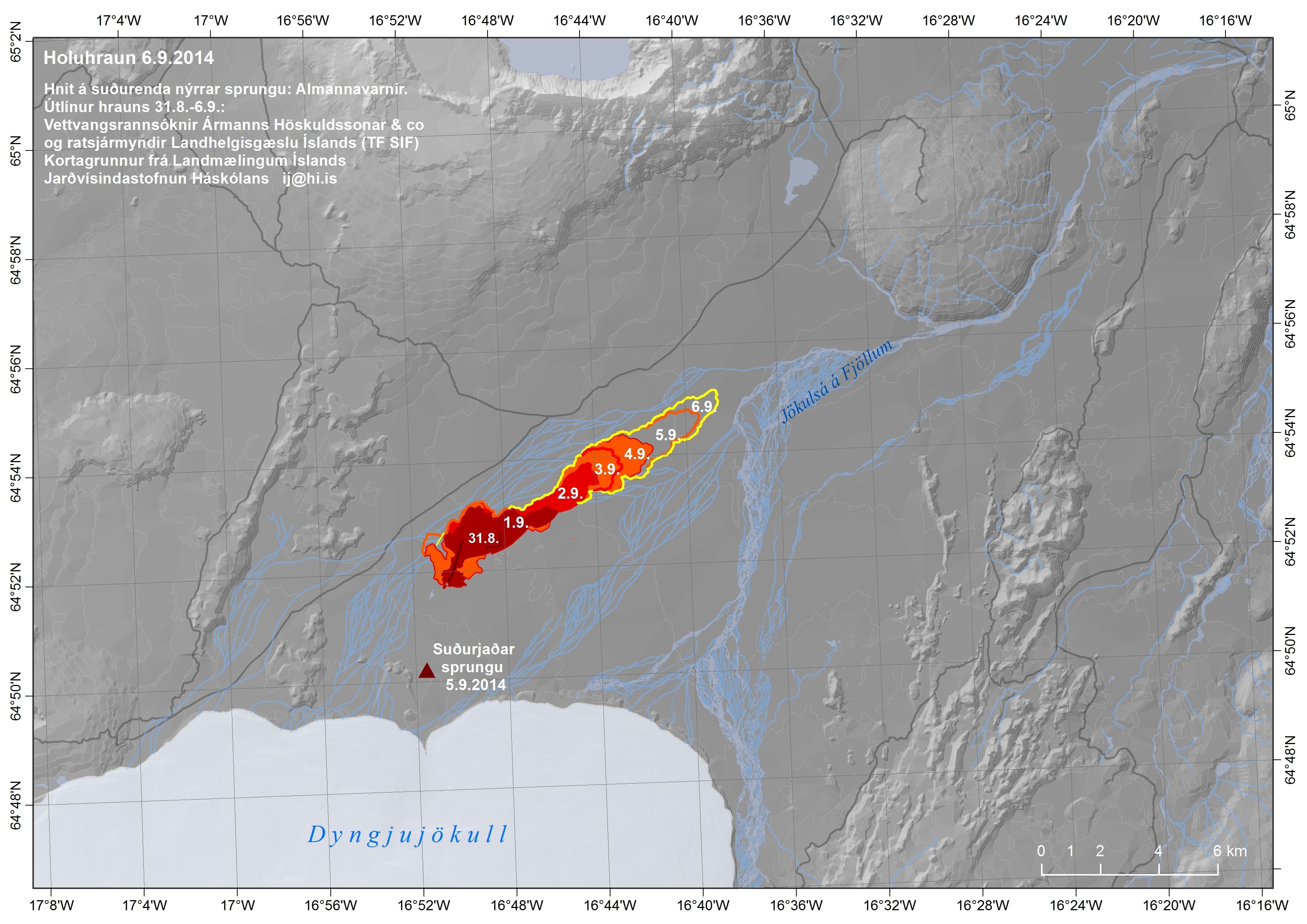
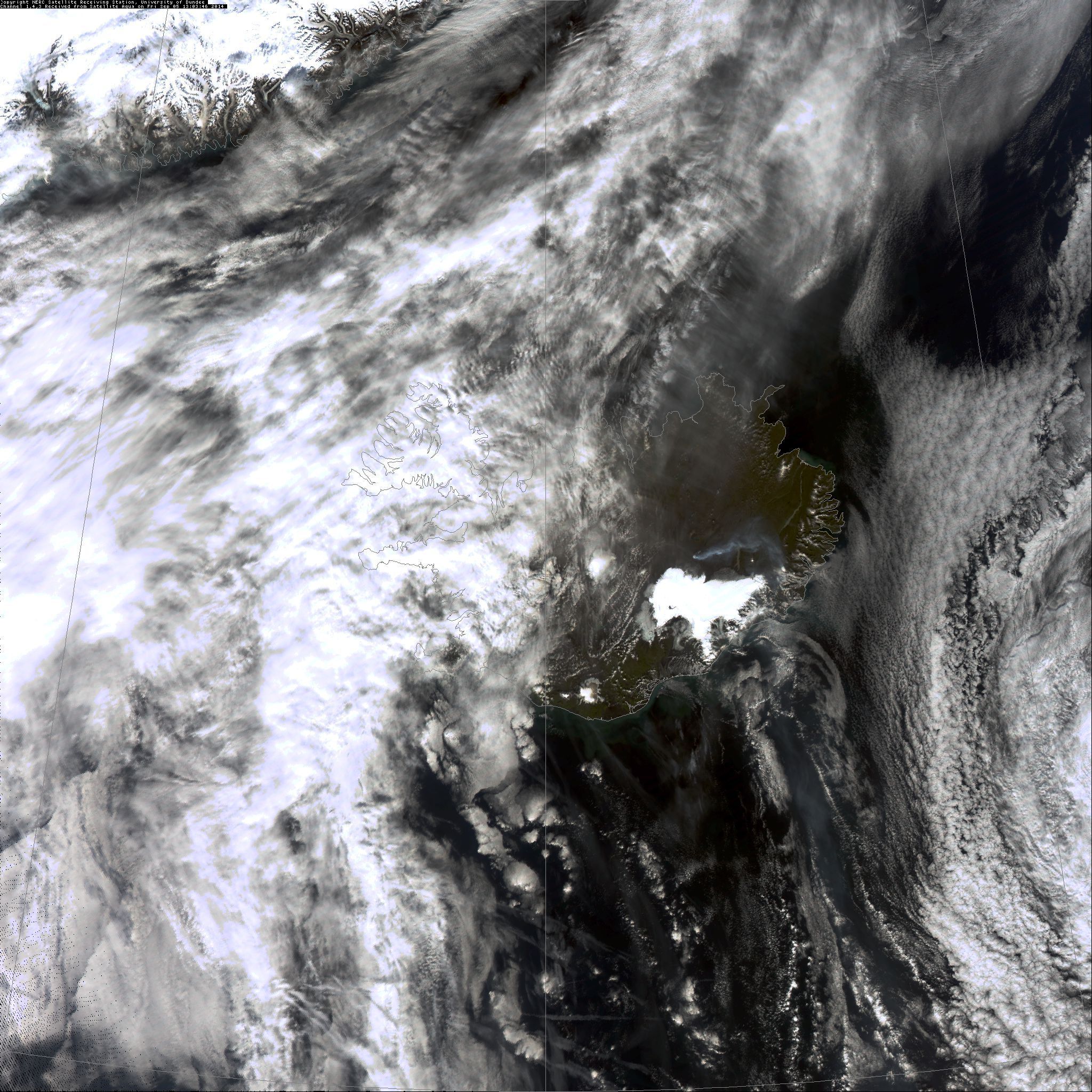
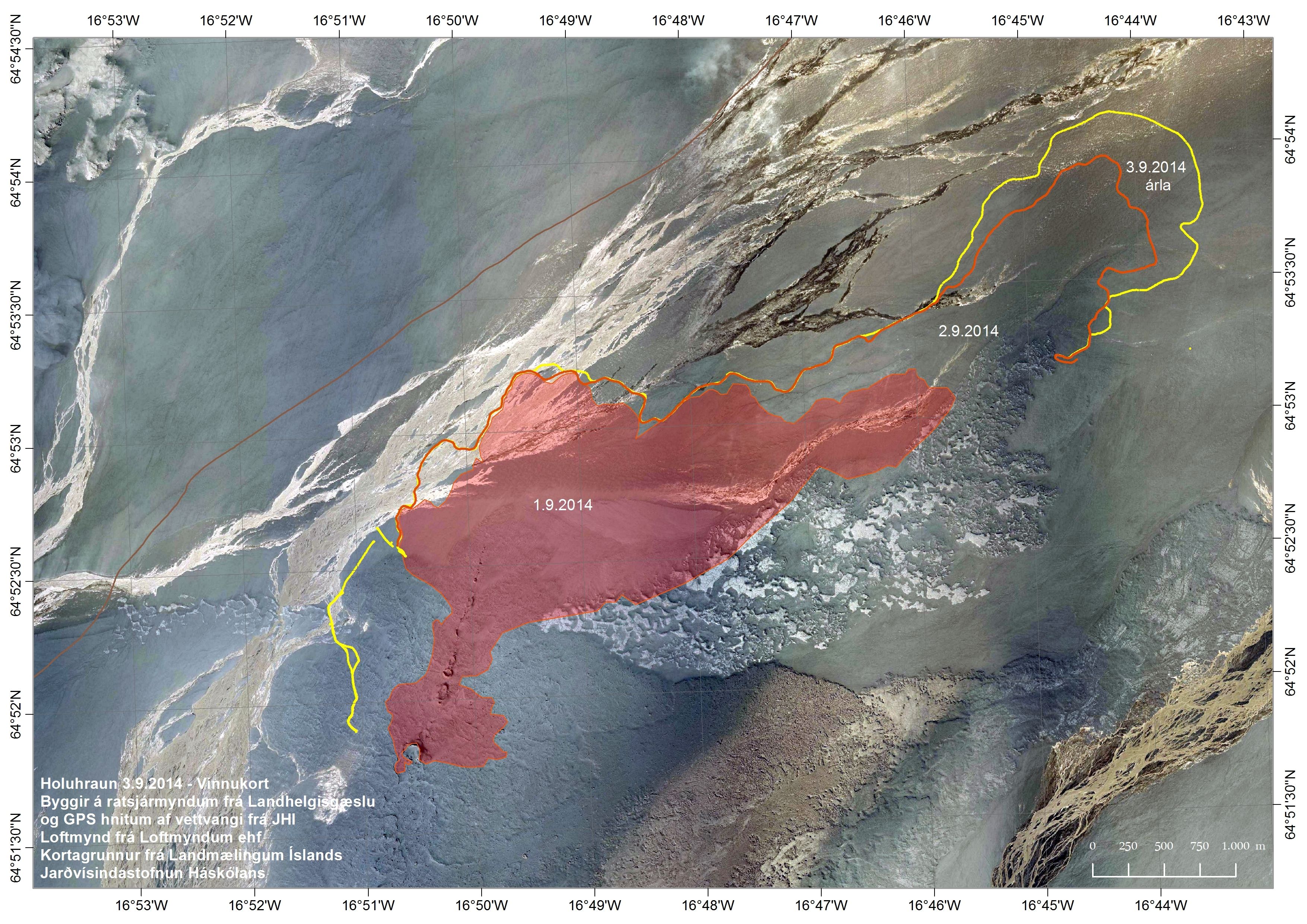
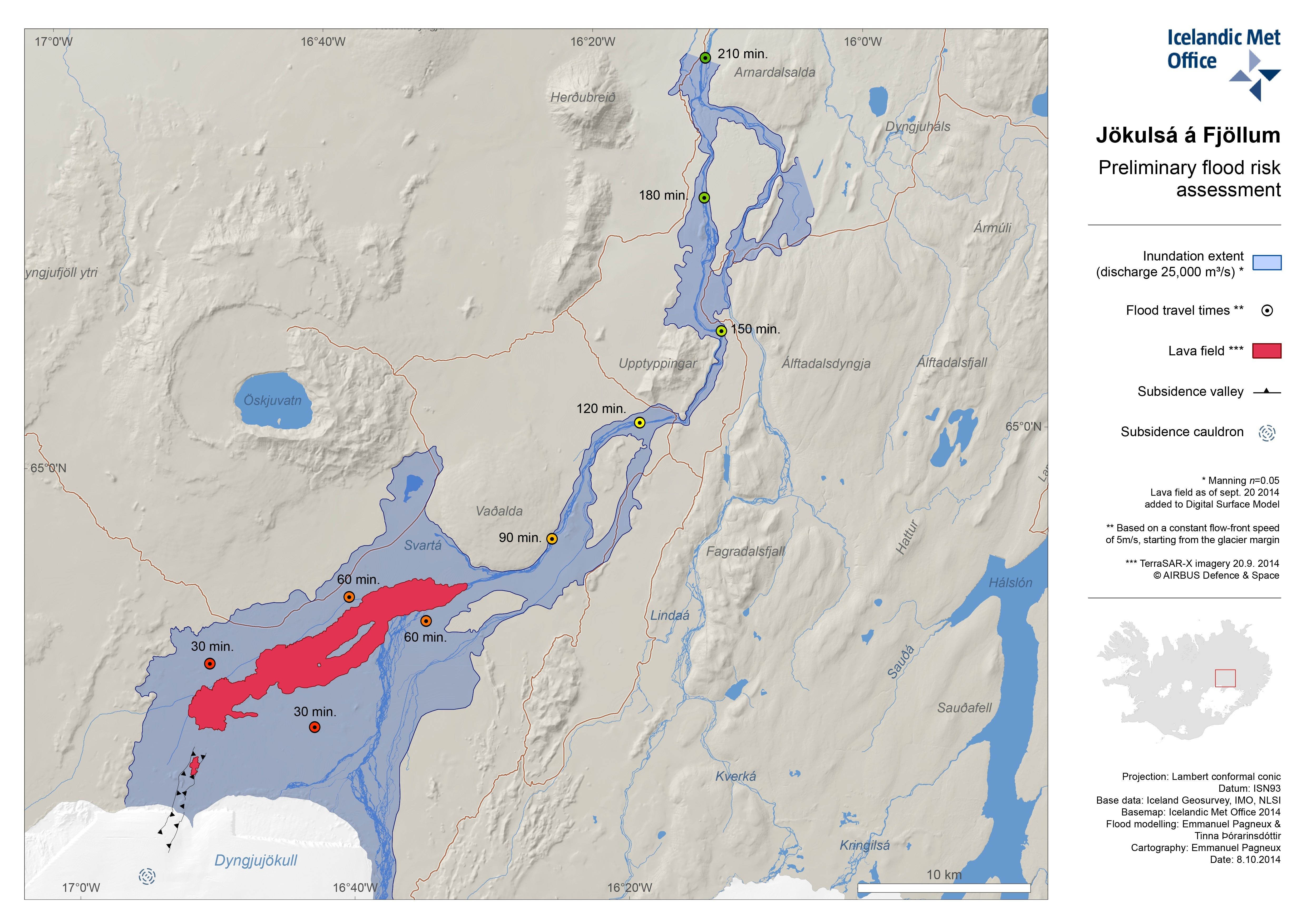