
News
Öræfajökull news
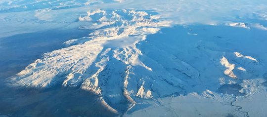
Öræfajökull, November 2017. Photo: Ágúst J. Magnússon.
The news articles below are presented here in reversed chronological order.
Status of Öræfajökull volcano – 13th July 2018
Following a series of meetings with scientists from Icelandic Meteorological Office, The University of Iceland and Iceland Geosurvey, The Department of Civil Protection issued a statement on the status of Öræfajökull. The Department of Civil Protection maintains a state of preparedness in the area.
IMO and the Icelandic Civil Protection Agency reassess the status for Öræfajökull. No imminent hazard to aviation - 4 May 2018
It is close to nine months since an unrest in Öræfajökull was detected. The unrest was apparent from elevated seismicity, the development of a depression in the ice-surface (cauldron) within the caldera, and the presence of geothermal gases from a glacial river. At this time, the geothermal activity beneath Öræfajökull was assessed to be high relative to previous decades.
As that behaviour was above known background conditions, it could potentially indicate increased risk of eruptive activity that could affect air traffic. Consequently, the Icelandic Meteorological Office raised the Aviation Color Code for Öræfajökull from Green to Yellow. At the same time, the Icelandic Civil Protection and Emergency Management raised their alert level to Uncertainty phase.
Since the unrest in September 2017, the level of monitoring around the volcano has increased significantly by the addition of new monitoring equipment. This increased capability means that any future unrest can be followed more closely, hopefully leading to an early warning of a potential eruption.
Monitoring Öræfajökull – update 22. Dec. 2017
Real-time surveillance around Öræfajökull has been improved in the last month to better monitor the seismicity (significantly increased since September this year) and the release of geothermal water from the caldera (detected the first time in mid-November).
New seismometers, hydrological stations, web-cams and GPS have been installed in the area and data are now streaming to the Icelandic Meteorological Office which is in charge of the 24/7 monitoring service.
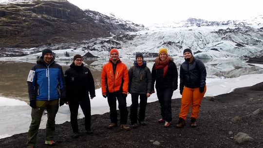
At Sólheimajökull. Some of IMO natural hazards monitoring staff members. Photo: Kristín Jónsdóttir.
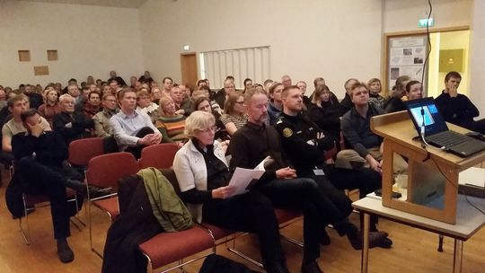
A community meeting in Öræfi 27 November 2017. Photo: Kristín Jónsdóttir.
Monitoring Öræfajökull
20.11.2017
Scientists from IMO, the Earth Sciences Institute of the University of Iceland and a representative of the Icelandic Civil Protection Authority flew over Öræfajökull Saturday 18 November to assess ice-surface changes in the volcano's caldera.
The overflights were made with helicopter support from the Icelandic Coastguard and an aircraft from Isavia. Additionally, water samples, measurements of electrical conductivity and gas levels were made on the ground at Kvíárjökull, a valley glacier on the southeastern flank of Öræfajökull. Apart from a stench of gas from the Kvíá river, there was no obvious sign of recent flooding. The ice cauldron that was reported on 17 November 2017 measures about 1 km in diameter and it is 15-20 m deep. While meltwater continues to drain from Kvíá, a large outburst flood seems unlikely.
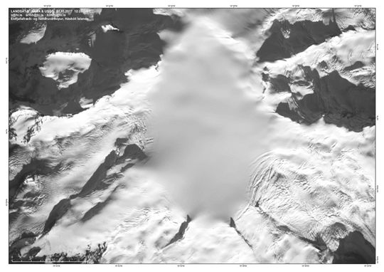
A new ice-cauldron in Öræfajökull volcano
17.11.2017
New satellite images of Öræfajökull volcano shows that a new ice-cauldron has formed within the caldera in the last week. Pilot flying over the area took pictures of the cauldron today and sent them to the Icelandic Meteorological Office. The cauldron is about 1 km in diameter and it reflects a recent increase in geothermal activity within the caldera.
Landsat image from 17 November 2017.
New seismic stations installed around Öræfajökull
3.11.2017
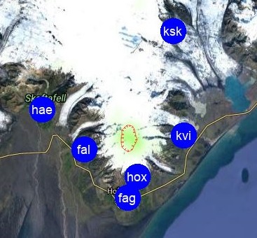
Seismic activity has been increasing in Öræfajökull volcano in the recent months and the Icelandic Meteorological Office (IMO) has responded by strengthening the surveillance in the area.
In the last week of October, staff from IMO installed two new seismic stations near the glacier Öræfajökull: at Háöxl (Hox), south of the glacier; and at Kvísker (Kvi), on the eastern side of the glacier. In addition earlier in the month, IMO gained access to the seismic station, owned by the British Geological Society, located near Falljökull (Fal), west of Öræfajökull. This station, which was installed for ice-quakes research, has proofed to be very beneficial to locate earthquakes in this volcanic area.
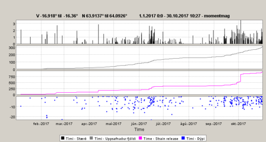
Seismicity in Öræfajökull volcano in 2017: Top, the graph shows the magnitude of each detected earthquake; the next graph shows the cumulative number of earthquakes; the third graph shows the cumulative seismic moment. From this graph it is well visible the M3.5 earthquake measured at the beginning of October 2017. This is the largest earthquake detected in Öræfajökull volcano since the beginning of the measurements; the last graph shows the depth of earthquakes in kilometers
More

