
Articles
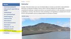
Reporting floods well appreciated
With the foreword that safety is most important, reporting on flood events is welcome. Apologies; the web form is still only available in Icelandic but fairly self-explanatory. Please have a go and comment in English, that would be well appreciated.
Read more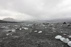
The outflow of the jökulhlaup at the terminus of Skaftárjökull
A field expedition to Skaftárjökull on Thursday 1 October revealed that the jökulhlaup had burst through the glacier at several locations, see photos and a video in another article.
Dark bands of debris extended down where the jökulhlaup had flowed. Ice fragments were scattered over the surface of the glacier.
The flood waters appear to have flowed through the glacier for some time and concentrated in one or more circular channels that the flow melted through the glacier.
Jökulhlaup in Skaftá - progress
The measured discharge at Sveinstindur peaked around 2:00 this morning, showing almost 2100 m³/s. True discharge may have been considerably greater.
The discharge at Eldvatn near Ásar peaked around 13:00 showing discharge of approximately 2200 m³/s. The area outside the main water channel will be flooded for coming days.
Three gas sensors have been installed, in order to monitor the gas released from the glacial outburst occurring along the Skaftá river.
Read more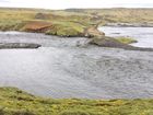
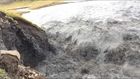
Skaftá jökulhlaup 2015 - photos from Búland
The farmers of Búland are ususally the first locals to witness these jökulhlaup events, now that farm Skaftárdalur (further inland) is not inhabited all year round anymore. Below Skaftárdalur the river Skaftá splits in three. One branch is Eldvatn beyond Ásar, through Flögulón and down into Kúðafljót. The second goes into Eldhraun at Árkvíslar. The third branch passes the town of Kirkjubæjarklaustur. The photos in this article of Skaftá river were taken by the farmers at Búland, Auður Guðbjörnsdóttir and Pétur Davíð Sigurðsson, 1st Oct. 2015. For orientation see a map of gauging stations.
Read more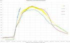
Possibly the largest jökulhlaup
The rate of discharge increase at Sveinstindur is the highest observed since the station was established in 1971. From initial observations, the ongoing jökulhlaup could be the largest to have occurred from the Skaftá cauldrons. The jökulhlaup will likely reach maximum discharge in the lower reaches of Skaftárdalur during the early hours of Saturday, 3 October.
Localised flooding should be expected. Gas will reach poisonous levels at the edges of Skaftárjökull, Tungnaárjökull and Síðujökull. Crevasses will develop rapidly around the ice cauldron, including the lower part of Skaftárjökull and Tungnárjökull.
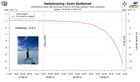
Ice surface lowering - striking graph
Floodwater continues to drain from the eastern Skaftá ice-cauldron. The latest GPS measurements show that the rate of ice-surface lowering continues to increase. This can now be observed on the web on a graph that updates every five minutes.
Localised flooding should be expected on the lower part of Skaftá late on Thursday, lasting through the weekend, and possibly at Hverfisfljót bridge. Gas will reach poisonous levels at the edges of Skaftárjökull, Tungnaárjökull and Síðujökull. Crevasses will develop rapidly around the ice cauldron, including the lower part of Skaftárjökull and Tungnárjökull.
Glacial outburst flood probably in progress
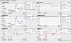
Various observations signify that a glacial outburst flood (jökulhlaup) is in progress in Skaftá river; including the water level at Sveinstindur and electrical conductivity readings. Data from the GPS-station in the Eastern Skaftá cauldron in Vatnajökull is also being closely monitored, the last jökulhlaup from there having occurred in 2010. Further information will be given later this afternoon.
Read more
An ice surge at Jökulsá á Fjöllum
An ice surge is occurring on Jökulsá á Fjöllum at Grímsstaðir. The ice that had formed on the banks and the surface of the river has broken into many fragments, creating an icy, slow moving mixture. Water is beginning to seep over the main road, west of the bridge.
In addition to this news article, see a photo gallery from the bridge including updated satellite images and aerial photos from a surveillance flight.
As the break-up of snow and ice continues, it is possible that water could continue to leak across the road. If the discharge of Jökulsá á Fjöllum increases due to snow-melt or rainfall, then the level of flooding could be greater.
Read moreProhibited area around the Holuhraun lava field
All traffic on tracks in the shaded areas is prohibited until further notice due to a danger of flooding in connection with a possible volcano eruption in the northern part of Vatnajökull glacier. The Civil Protection and Emergency Management of Iceland has declared a danger level in the area.
Read more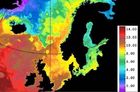
Climate change and hydrology: Environmental and societal effects
The climate and hydrology of Iceland are highly variable due to natural conditions. Significant changes in these factors over the last 15 years are in harmony with the future scenarios represented and affirmed in the latest IPCC summary report, AR5. The main purpose of IMO is to contribute towards security in society by monitoring, analyzing, interpreting, informing; providing warnings and forecasts and predicting natural hazards. It is important to keep the infrastructure strong so that IMO may fulfill its role.
Read more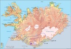
Increased glacial melt due to volcanic ash
In some areas of Iceland's glaciers, where ash from the Eyjafjallajökull volcanic eruption was sufficiently thick, glacial melt increased. However, on western Mýrdalsjökull ice cap which is next to Eyjafjallajökull, the ash was so thick that it acted as an insulator. Therefore, Markarfljót River had no increase in water discharge during the period of glacial melt.
Read more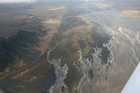
Flood warning system and jökulhlaups - Eyjafjallajökull
Jökulhlaups (glacier outburst floods) are more common in Iceland than elsewhere in the world because of the interaction of volcanoes with glaciers. The greatest jökulhlaups from the subglacial Katla volcano are among the largest floods that humans have witnessed.
Read more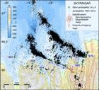
Grímsvötn 2010
A glacier outburst flood (jökulhlaup) emerged from beneath the Vatnajökull ice cap on October 31, 2010. The floodwaters originate in the subglacial lake Grímsvötn, 50 km upstream from the glacier margin. This article presents updated information daily.
Read moreRelated topics
Search
Contact IMO
© Veðurstofa Íslands | Bústaðavegi 7- 9 | 105 Reykjavík | Phone 522 6000 | Fax: 522 6001
Recording 902 0600 | SSN 630908-0350
Contact us | Employees | Terms and conditions | Sitemap


