Climate change and hydrology: Environmental and societal effects
Networks and knowledge
What are the characteristics of the hydrology of Iceland? Bedrock conditions greatly influence water movement. Surface-fed rivers are mostly confined to the Tertiary areas (>3.1 million years old) found in the East fjords, the northen West fjords and in Tröllaskagi in the north.
Conversely, the spring-fed and glacial rivers drain catchments within the volcanic rift zone, which lies across central Iceland from SW to NNE. There, the bedrock is much younger (<3.1 million years), has high porosity and is easily erodible. Seasonal fluctuations in spring-fed rivers are low, but great in surface-fed rivers and more so in glacial rivers. Moreover, ice-caps and glaciers influence the hydrology greatly.
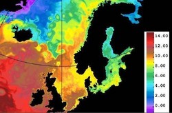
What are the characteristics of the climate? And how does it affect the hydrology? Iceland is located in the Atlantic Ocean at the boundaries of the polar front and the warm temperate air mass (fig. 1); resulting in unstable weather conditions with abundant lows and high precipitation where snow plays a major role. In winter, water is stored as snow that gives rise to spring floods when the temperature rises.
The Icelandic Meteorological Office (IMO) collects and maintains data on all these parameters, spanning decades. Through participation in international projects, hydrological maps for Iceland are available as well as long time-series on temperature, including maps of temperature anomalies and high-resolution precipitation maps.
Influence of climate change on glaciers
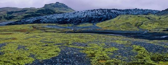
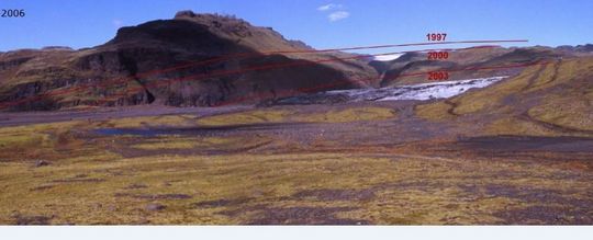
Most glaciers in Iceland have retreated during the last decade or so, except for surging glaciers. Simulation calculations indicate that most Icelandic glaciers will retreat and eventually disappear over the next 100-200 years. These changes can already be seen at Sólheimajökull (fig. 2) and Snæfellsjökull. Forecasts of the retreat of Langjökull and Hofsjökull until 2100 have been made (Institute of Earth Sciences and Tómas Jóhannesson, IMO).


Fig 2. The retreat of Sólheimajökull. On the central photo red lines show the glacier‘s margin as it was in 1997, 2000 and 2003. Photos: Oddur Sigurðsson. Click to enlarge.
Influence of climate change on hydrology and discharge
A forecast has been made on the change in discharge of the glacial river Jökulsá Austari in Skagafjörður (fig 3). A progressive change seems to be under way; higher average discharge is predicted for the years 2021-2050 than the measured discharge 2001-2009, which again is significantly higher than that for 1961-1990.

Effects on hydropower
According to predictions, run-off in utilized rivers will have increased by 27-84% in 2050. Which means:
- The potential energy of currently utilized rivers will increase by 20%.
- The current system can only utilize less than half of this energy increase due to its limited capacity.
- These results must be applied when redesigning and upgrading the hydropower plants.
Effects on sea level
Regional scenarios have been made for changes in sea level due to climate change where the estimated sea level in 2081-2100 is compared to the sea level in 1986-2005.
The situation is complex for Iceland: Greenland´s ice sheet exerts gravitational attraction on the sea around it and Iceland is located within this influence, leading to higher sea level. The melting of the ice-sheet causes changes in its gravitational force. Averaged globally the sea level rises but on a local scale, due to the diminishing volume and mass of the ice sheet, its gravitational attraction decreases, resulting in lower sea level locally. Consequently, the sea level will not rise as much around Iceland as one would expect, given global conditions.
Infrastructure for a purpose
The main purpose of IMO is to contribute towards increased security and efficiency in society by monitoring, analyzing, interpreting, informing, providing warnings and forecasts and where possible, predicting natural processes and natural hazards. IMO´s role is issuing public and aviation alerts about impending natural hazards as well as conducting research on the physics of air, land and sea. Also ensuring the accumulation and preservation of data and knowledge regarding the long-term development of natural processes. With regard to weather and water, the Icelandic Meteorological Office relies on:
- A network of stations for climate and hydrology as well as various measurements of glaciers.
- EUMETSAT satellite data on weather, water, earth and ocean (Iceland became a full member in 2014).
- ECMWF simulations on weather and climate (Iceland became a full member in 2011).
- High resolution calculations with climate models.
- Hydrological models.
All stakeholders and concerned parties reached a consensus on the financing of the network of hydraulic gauging stations 25-30 years ago. The network was run by the National Energy Authority until 2009 when its Hydrological Service merged with the Icelandic Meteorological Office, creating a new institution (IMO). The financing of the network system in 2014 is shared as follows: IMO´s base network 34%, IMO‘s flow warning network 9%, various national and local power companies 40% and finally Reykjavik City and others 17%.
In spite of the increased importance of this resource, the network system has diminished by 30% since 2008, i.e. fewer gauging and monitoring stations are operating today.
Summary
- The climate and hydrology of Iceland are highly variable due to natural conditions.
- Significant changes in these factors over the last 15 years are in harmony with the future scenarios represented and affirmed in the latest IPCC summary report, AR5.
- It is imperative to strengthen the infrastructure in order to avoid loosing valuable data.
- The monitoring of water and its usage must be improved in order to combat the decline which has occurred in recent years although the importance of the water resource has never been greater and more obvious.
Conclusion
What impacts will global warming have on hydropower in Iceland?
Increased run-off will result in about 20% increase in potential energy, but our current hydropower stations can only exploit less than half of that increase. Thus our systems must be redesigned and upgraded, building upon the present network of gauging stations for weather and water. Despite increased importance of this resource, fewer gauging and monitoring stations are operating today than in 2008.
It is crucial to improve the infrastructure in order to prevent the loss of valuable data. Especially, direct hydrological measurements must be supported.
Reference material for Iceland
Annual articles on the climate
Map of avalanche notifications
Articles on the 2010 Eyjafjallajökull eruption
Articles on the 2011 Grímsvötn eruption


