
100 years since Katla erupted
Today, 12 October, is the 100-year anniversary of the 1918 eruption of Katla. The volcano is considered one of the most hazardous of Iceland's 32 active volcanic systems. During the last 1100 years, Katla has erupted at least 21 times, with an average repose interval of around 50 years. The current one-hundred-year repose marks the longest period since a Katla eruption. The Katla volcanic system is located in the eastern volcanic zone. It is characterized by an 80-km-long fissure swarm and an ice-clad central volcano. The central volcano is covered by the Mýrdalsjökull ice-cap and it includes a 9 by 14 km caldera, with ice-thickness up to 700 m.
Historical eruptions of Katla are predominantly explosive, generating ash-rich plumes and glacial outburst floods (jökulhlaups). In historical times, jökulhlaups have inundated Mýrdalssandur, to the east. Prehistoric jökulhlaups are also known to have drained to the west and north-west of the volcano, affecting Markarfljót.
Lava-forming eruptions can also occur on the volcano's fissure swarm, the most recent of which was the Eldgjá eruption around 939 CE that produced ~20 km3 of lava and tephra. In comparison, the Holuhraun eruption (2014-2015) produced about 1,5 km3 of lava.
The monitoring of Katla at the Icelandic Meteorological Office
Natural hazard monitoring at the Icelandic Meteorological Office (IMO) is mainly based on data analysis from seismometers, deformation measurements (GPS, borehole-strain meters and InSAR), hydrological measurements, gas sensors, infrasound measurements, web cameras and other specific measurements, e.g. surveillance flights to monitor the ice surface and the development of geothermal activity and possible meltwater accumulation. In addition, while an eruption is ongoing, an operational monitoring system exists to track ash dispersion.
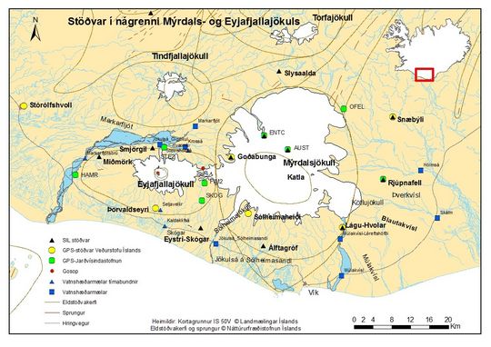
The monitoring network around Katla volcano is dense. Seismic stations
are marked as black triangles (SIL-stations). Missing from the map are
gas-sensors at Sólheimaheiði and Sólheimajökull, a bore-hole strain meter at
Eystri-Skógar and other instruments farther away, which are also significant
for volcano monitoring, e.g. infrasound sensors in Kirkjubæjarklaustur and
Gunnarsholt. The monitoring network changes slightly from year to year, but the
overall tendency is intensification.
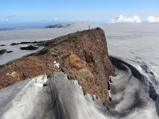
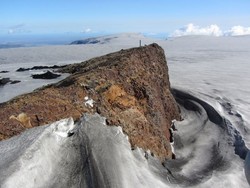
Austmannsbunga is a nunatak in the northeast of the Katla caldera,
surrounded by glacial ice. It is one of the few outcrops of bedrock on
Mýrdalsjökull. A seismic and GPS station are located on Austmannsbunga. (Photo: Oddur Sigurðsson.)
Dense monitoring network around Katla
Being one of the most active and dangerous volcanos in Iceland, Katla is monitored with a variety of sensors. Ten seismic stations, surrounding the volcano stream data in real-time to IMO where an automatic algorithm calculates earthquake magnitudes and locations. Infrasound data, hydrological data and gas data are also sent in real-time or with an interval of minutes. GPS-measurements are sent at hourly intervals as they are used for long-term monitoring (some are streamed as well). Seismic and volcanic unrest is followed by 24/7 monitoring and automatic warning systems that are triggered when activity increases.
The natural hazard monitoring at the Icelandic
Meteorological Office (IMO) is mainly based on data analysis from seismometers,
deformation measurements (GPS, borehole-strain meters and InSAR), hydrological
measurements, gas sensors, infrasound measurements, web cameras and other
specific measurements, e.g. surveillance flights to monitor the ice surface and
the development of geothermal activity and possible meltwater
accumulation. In addition, while an
eruption is ongoing, an operational monitoring system exists to track ash
dispersion.
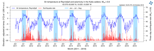
The graph shows seismicity (three-day earthquake rate, in red) from 2011. Seismicity is often elevated during June, July and August (these months are shown in light blue). In dark-blue, the air temperature at Reynisfjall is shown, adjusted to the elevation of the Katla caldera. A couple of explanations have been suggested to explain the seasonal seismicity, for example increased pore-fluid pressure can cause increased seismicity. Decreased glacial loading could also be another explanation.
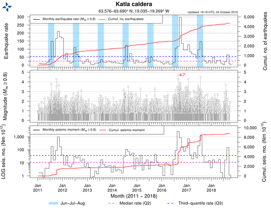
This graph shows seismicity since 2011. High earthquake rates are observed, and the largest earthquakes have magnitudes above M4. Seismicity has decreased in the past year.
When will Katla erupt?
Seismic activity in Katla has, in recent years, been mainly characterized by shallow seismicity in the caldera. The seismicity intensifies in late summer and during the fall, an effect which is probably unrelated to volcanic processes. Compared to other volcanic systems in Iceland, Katla volcano is one of the most seismically active. Deformation studies in recent years do not indicate significant deformation caused by magma influx and accumulation. Despite that, several studies indicate magma storage in the roots of the volcano. This is suggested by an extensive geothermal area within the caldera.
At this stage, it is difficult to forecast the next eruption of Katla. However, before the next eruption, it is expected that IMO's monitoring systems will detect precursory activity, such as increased seismicity, changes in seismic patterns, inflation of the volcano, changes in gas-fluxes and ratios, and changes in hydrological measurements.
For further details, see:
Catalogue of Icelandic Volcanoes.


