
News
Update on the earthquake swarm in Geldingadalir
Please view this page for the latest information on seismic activity.
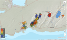
Update on 29.12. at 11:53
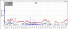
Since midnight around 90 earthquakes have been detected. Yesterday there were around 1300 earthquakes detected in the Reykjanes peninsula as a whole. This is a lot less than the day before when around 2300 earthquakes were detected.
The scientific
Advisory board for the civil protection services met on the 27th of December to
go over the situation near Fagradalsfjall. GPS instruments and satellite
interferograms show that the magmatic intrusion is limited to a dike intrusion
by Fagradalsfjall, similarly as in February and March 2021 before the eruption
onset on the 19th of March.
Flood in Grímsvötn
Update 8.12. at 12:30
The Icelandic Meteorological Office elevated the aviation color code from yellow to orange on the 6th of December for Grímsvötn volcano when the seismic actvity increased above normal level in the aftermath of the glacial outburst (which peaked on 05.12). On that day a M3,6 earthquake occurred at 6:16 UTC and 15 more earthquakes occured within the day. However, yesterday (07.12) very few earthquakes were identified in the area and the geophysical parameters all showed normal values. Based on these current observations, IMO moved the aviation color code from orange back to yellow as there were no clear indications for an imminent eruption.
Read more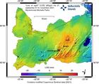
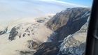
Update on Fagradalsfjall
Since 18th of September no eruptive activity has
been observed at Fagradalsfjall, but there are still small quantities of gas
measured in the atmosphere. During the eruption a deflation signal was detected around Fagradalsfjall, most likely due to magma
withdrawal from a deep reservoir which was feeding the eruption.
Joining forces in weather forecasting and climate research
The National Weather Services of Denmark, Iceland, Ireland and The Netherlands are joining forces to jointly operate a new supercomputer and to bring significant advancements to short-term weather forecasting services.
Read more
The Civil protection crisis level lowered from alert to uncertainty phase
During the past month (18th September - 18th October) no lava flow from the crater has been detected at Fagradalsfjall volcano. Out gassing is still ongoing with very low concentrations of eruptive gases. Similarly, thermal anomalies continue to be detected at lower values and greater intervals between detection's.
Read more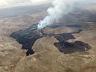
“The small eruption” in Fagradalsfjall celebrates six months
Yesterday, 19th of September marks 6 months since the beginning of the eruption. The lava flow from this eruption is thought to be relatively small compared to other eruptions in Iceland. However, due to its location and easy access for scientists and the public it has had a bigger impact and made more challenges then other eruptions.
Read more
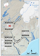
Flood from Skaftá
The flood in Skaftá is still ongoing but the discharge has lowered significantly.
The water level in Tungulækur, which is a groundwater stream from Eldhraun, continues to rise slightly, indicating that floodwater is still spreading through the lava. Gas pollution close to the edge of the Skaftá river remains a possibility.
Read more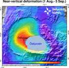
Uncertainty level declared for the ongoing uplift at Askja volcano
The National commissioner in agreement with the Police Department of the North-East Iceland declared the uncertainty level because of the ongoing uplift at Askja volcano. In the last weeks fast deformation changes have been measured in Askja, both from GPS stations and processed satellite images. The uplift has reached about 7 centimeter and that is a significant change over this temporal period.
Read more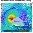
Uplift signal detected in Askja volcano
GPS observations and ground deformation maps derived from Sentinel-1 satellite data reveal that Askja volcano began inflating at the beginning of August 2021. The uplift signal is centered on the western edge of Öskjuvatn, close to Ólafsgígar. The cause of such inflation is uncertain, but most likely it is due to the inflow of new magma. Active volcanoes in Iceland, like Askja, are often characterized by periods of inactivity, lasting years to decades, with intervals of enhanced seismicity, geothermal activity, and inflation. In most cases, magmatic intrusions do not culminate into an eruption.
Read more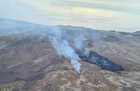
Re-evaluation needed of the size of the hazard area
Updated 03.05 12:15
The eruption in Fagradalsfjall continues
through one main crater. The active crater is the fifth fissure opening that opened in the area on the 13th of April. Since the 27th of April, the volcanic activity was characterized by continuous lava fountains, while the activity changed at around midnight on the 2nd of May, and has since been showing pulsating behaviour.
Considering these changes in activity, the size of the hazard area at the eruption site is being re-evaluated.
Read more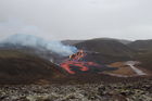
A minor eruption underway
Uptdated 29.3 at 09:30
The Civil Protection and Emergency Management's Science Board held a meeting Friday (Mars 26.) to discuss the volcanic eruption in Geldingadalir on the Reykjanes Peninsula.
A lot of data has been collected including on-site and remote measurements along with modeling work forecasting the event's possible behavior over the coming days. A report detailing the event's general status and proposals for regular monitoring will be released shortly.
Read moreThe weather in Iceland in 2020
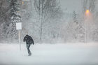
The year 2020 was stormy. The average wind speed was remarkably high and number of windy days was unusually high.
The annual mean temperature at all stations was higher than the 1961 to 1990 mean, but below the average of the last ten years. It was relatively warmer in the East and Northeast but colder in the Southwest and West.
The year was wet in the North and East. The annual precipitation in Akureyri has never been higher since the beginning of registration in 1928.
Read more
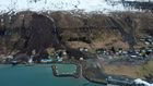
The landslide in Seyðisfjörður is the largest landslide to have damaged an urban area in Iceland
From 15 to 18 December 2020, several landslides hit the town of Seyðisfjörður, destroying or damaging more than 10 buildings. Thankfully, there were no injuries. The largest landslide occurred on 15 December, and it ranks as the most damaging landslide to have affected an urban area in Iceland.
Read moreSearch
Contact IMO
© Veðurstofa Íslands | Bústaðavegi 7- 9 | 105 Reykjavík | Phone 522 6000 | Fax: 522 6001
Recording 902 0600 | SSN 630908-0350
Contact us | Employees | Terms and conditions | Sitemap


