
News

Safetravel in winter
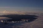
Increasingly, tourists come in winter to enjoy the beauty of the northern lights. Safety while travelling is always crucial, especially in winter conditions.
The web-site Safetravel is run by ICE-SAR in order to minimize the risk of accidents in travelling and tourism in Iceland.
Thorough information on safe travelling can be found there. The 112 Iceland app can be downloaded and your travel plan can be left in safe hands before you go. Additionally, a personal location beacon can be rented at two pick-up places.
Read more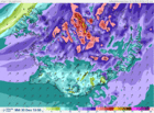
Storm in the North and calmer in the East
The low is now north of Iceland and wind has started to decrease in the east. Storm in the North at noon or after noon.
Southwest 18 - 28 and wintry showers by noon, strongest wind in the north. Decreasing winds late afternoon. Mostly dry in the northeast tonight. South and southeast 8 - 15 m/s tonight and tomorrow, snow or snow showers but mostly dry in the north. Temperature 0 to 5 °C today but colder tomorrow.
Read more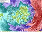
Warning due to violent storm
Violent storms, or even hurricane force winds, are forecast in the eastern parts of the country tonight and during the morning, first in the southeastern parts.
A low pressure of 958 mb is rapidly deepening far to the south of Iceland, moving fast in a northerly direction. Air pressure of 934 mb is forecast soon after midnight and 933 mb in the northeast at 7:00 UTC tomorrow morning.
Boat owners should secure their boats due to high tides after midnight in the East. Also, the public is advised to fasten loose objects outside.
Floods in the Southeast and East fjords
Due to precipitation and melting, increased water levels are prevalent in the Southeast and in the Eastfjords. Rivers Geithellnaá and Fossá in the fjord Berufjörður are flooding. Their discharge has grown by a factor of ten within 24 hours. River discharge will continue to rise in the Southeast and towns may experience flooding streets. Snow avalanches with high water content have occurred and mudflows may occur.
Read more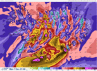
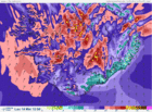
Weather warning – hurricane force winds
Violent storm or hurricane-force winds are expected throughout most of the country tomorrow afternoon and tomorrow evening. The magnitude of the approaching storm is so great that such conditions occur only every 10 to 20 years.
Significant snowfall will accompany the beginning of the storm, resulting in blowing snow and little or no visibility. According to the latest forecast, the oncoming violent storm tomorrow, Monday, will be far more severe than the storms in recent days.
Read more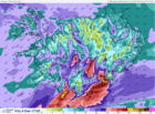
Weather warning - violent storm
A strong gale warning is in effect in Iceland this afternoon and tomorrow. Violent storm is expected in the southernmost part and in the southeast between 15:00 and 20:00 this afternoon.
Travelling conditions in the south and southeast are expected to be extremely poor.
Southwest Iceland, including the capital area, will have near gale wind and blowing snow along with intermittent light snow.
Overnight and tomorrow the risk of avalanches will increase in the Westfjords and in North-Iceland.
Read more
Violent storm expected in the South
A strong gale warning (average windspeed above 20 m/s) is effect in Iceland today, Friday 4th December, and a violent storm (average wind speed, above 28 m/s) is expected in the southern most part as well as in the southeast.
Travelling conditions in the south and southeast are extremely poor on Friday.
On Saturday a strong gale with snow and decreased visibility is expected in the northern part.
Read more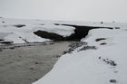
Hofsjökull ice cap gains mass
All ice caps in Iceland have been retreating rapidly and losing volume since 1995, but in 2015 the Hofsjökull ice cap in the central highlands displayed positive mass balance.
A positive mass balance on Hofsjökull in this year did not come as a surprise, given the high levels of snowfall in Iceland during the winter and low melting rates due to a cool summer.
It would be premature to assume that this signals a reversal of climate conditions in Iceland, because single cool years sometimes occur within warm periods. The year 2015 is very likely to become the warmest year recorded on Earth since the start of instrumental observations.
Read more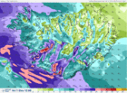
Warning due to a strong gale
Increasing easterly winds tonight in the southwest, including the capital area.
Early tomorrow morning, decreased visibility due to blowing snow, both in the capital region as well as en route to the KEF airport. Before noon, winds increase with large amounts of snowfall.
Increasing winds and precipitation are expected in Eastern Iceland tomorrow afternoon, with deteriorating travel conditions.
Read more
The weather app improved
Weather forecasts and the current weather condition can be checked through an improved weather app provided by IMO.
Forecasts are now provided for each hour and the meteograms are available again.
Location is detected if GPS on; alerts issued by the Met Office appear automatically during the day and a personal weather watch can be arranged.
An interactive weather map shows weather observations at any station in the country.
Read more
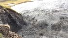
The outflow of the jökulhlaup at the terminus of Skaftárjökull
A field expedition to Skaftárjökull on Thursday 1 October revealed that the jökulhlaup had burst through the glacier at several locations, see photos and a video in another article.
Dark bands of debris extended down where the jökulhlaup had flowed. Ice fragments were scattered over the surface of the glacier.
The flood waters appear to have flowed through the glacier for some time and concentrated in one or more circular channels that the flow melted through the glacier.
Jökulhlaup in Skaftá - progress
The measured discharge at Sveinstindur peaked around 2:00 this morning, showing almost 2100 m³/s. True discharge may have been considerably greater.
The discharge at Eldvatn near Ásar peaked around 13:00 showing discharge of approximately 2200 m³/s. The area outside the main water channel will be flooded for coming days.
Three gas sensors have been installed, in order to monitor the gas released from the glacial outburst occurring along the Skaftá river.
Read more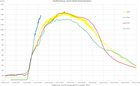
Possibly the largest jökulhlaup
The rate of discharge increase at Sveinstindur is the highest observed since the station was established in 1971. From initial observations, the ongoing jökulhlaup could be the largest to have occurred from the Skaftá cauldrons. The jökulhlaup will likely reach maximum discharge in the lower reaches of Skaftárdalur during the early hours of Saturday, 3 October.
Localised flooding should be expected. Gas will reach poisonous levels at the edges of Skaftárjökull, Tungnaárjökull and Síðujökull. Crevasses will develop rapidly around the ice cauldron, including the lower part of Skaftárjökull and Tungnárjökull.
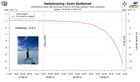
Ice surface lowering - striking graph
Floodwater continues to drain from the eastern Skaftá ice-cauldron. The latest GPS measurements show that the rate of ice-surface lowering continues to increase. This can now be observed on the web on a graph that updates every five minutes.
Localised flooding should be expected on the lower part of Skaftá late on Thursday, lasting through the weekend, and possibly at Hverfisfljót bridge. Gas will reach poisonous levels at the edges of Skaftárjökull, Tungnaárjökull and Síðujökull. Crevasses will develop rapidly around the ice cauldron, including the lower part of Skaftárjökull and Tungnárjökull.
Glacial outburst flood probably in progress
Various observations signify that a glacial outburst flood (jökulhlaup) is in progress in Skaftá river; including the water level at Sveinstindur and electrical conductivity readings. Data from the GPS-station in the Eastern Skaftá cauldron in Vatnajökull is also being closely monitored, the last jökulhlaup from there having occurred in 2010. Further information will be given later this afternoon.
Read more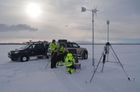
Articles on Bárðarbunga and Holuhraun
In early April 2015 the natural hazards banner was removed from the header of IMO‘s website. The short-cuts can now be found in an overview article which contains all the links on these issues provided by IMO since August 2014.
Gas emission from the lava field is still being monitored by continuous measurements around Holuhraun. The gas dispersion model is still operational but text forecasts are no longer made.
Seismic monitoring is as thorough as before and on any significant increase, the natural hazards banner will be presented in the header of all IMO‘s web-pages again.
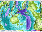
Heavy rainfall and increased river discharge
A low is approaching Iceland Saturday morning and high precipitation levels are forecast until early Sunday morning for much of S- and W-Iceland. Heavy rainfall is expected in the southeastern part of the country, leading to increased discharge in rivers and creeks in lowland and highland regions, which can trigger landslides. Special caution is required when attempting to cross unbridged rivers under these conditions.
Read more
Web downtime due to maintenance
Due to the renovation of our electricity systems, IMO's web will be inaccessible this afternoon and until evening. Expected downtime is from 3:30 PM to 8:00 PM.
We apologize for any inconvenience this may cause. Warning and notes will be published at our Facebook page if necessary.
Warning due to intense rainfall
Intense rainfall is expected in south-east Iceland and the Snæfellsnes peninsula with rising river levels from Eyjafjallajökull to Djúpivogur in the East Fjords. In mountainous coastal regions, intense rainfall could trigger hazardous landslides and mudflows without warning.
All travel plans should be made considering the latest weather warnings. Travellers are advised to stay away from all watercourses and strongly advised against crossing streams and rivers in the above-mentioned regions.
Read more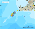
Earthquake swarm diminished and AVCC code lowered
IMO has lowered the aviation colour code at Eldey volcano from yellow to green. The seismic swarm on the Reykjanes ridge has significantly diminished in intensity and there are no direct signs of magma movements in the shallow crust. Water samples collected on 1 July do not show any spatial anomalies in pH or electric conductivity around the area of the seismic swarm.

Slight web hitch possible
Because of maintenance work, some slight hitch in our web services is possible today and tomorrow. The users of vedur.is and en.vedur.is might experience hectic appearance of web pages and the downloading of data will be slower than usually. This maintenance is part of a project which will improve IMO's services in the future.
Read more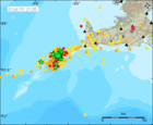
The earthquake swarm on Reykjanes ridge
As said earlier, an intense earthquake swarm started on 30 June near Geirfuglasker on the Reykjanes Ridge. The first burst of activity calmed down around midnight and activity is since occurring in pulses. Similar swarms have been recorded in previous years and have generally lasted up to a couple of days without resulting in an observable eruption. Based on the evidence that the current seismicity is well above the normal background condition, it has been decided to raise the aviation color code for Eldey volcano from green to yellow.
Read more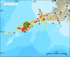
Earthquake swarm on the Reykjanes ridge
An earthquake swarm started yesterday at 21:00 on the Reykjanes ridge, about 30 km southwest of the tip of Reykjanes peninsula. The strongest earthquake so far is an M5.0 at 02:25 and it was well felt on the peninsula and in the capital area, as well as on a ship around 10 km away from the epicenter. The first burst of activity lasted until midnight. Since then, activity has occurred in pulses with two to three hours in between.
Read more
Warning – strong wind and sharp gusts in the South
Strong wind and sharp gusts are expected by Eyjafjöll, in Mýrdalur and in Öræfi by late evening tonight (Thursday) and tomorrow. Wind will not decrease until late tomorrow evening (Friday). In these conditions, trailers, house trailers etc. might cause trouble on the road. Travellers with such equipment are advised not to drive through these areas until winds have calmed down (Friday night or Saturday morning).
Read more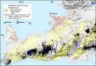
Increased seismic activity between Krýsuvík and Ölfus
In recent weeks, increased seismic activity has been detected on the Reykjanes peninsula. Historic recordings show that earthquakes in that region can be up to M6.5. The last earthquakes of M>6 were in 1929 and 1968. Both of these events caused no major damage in the capital area. In modern times, however, urban settlements have spread closer to historically active earthquake faults.
Warning - glacial outburst flood at Skaftá
Flood conditions are expected in Skaftá over the next two to three days. Some flooding of unpaved roads close to Skaftá is possible. Hydrogen sulphide is released from the floodwater as it drains from the Vatnajökull ice-cap. The gas is particularly potent at the ice margin, where concentrations will reach poisonous levels. Travellers must stay away from the edges of Skaftárjökull, Tungnaárjökull and Síðujökull while the flood occurs. Crevasses will develop rapidly around the ice cauldron, so travellers on Vatnajökull should stay away from the region, including the lower part of Skaftárjökull and Tungnaárjökull, where floodwater could burst through the surface.
Read more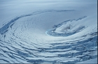
Final Conference of the SVALI project
The Final Conference of the Nordic Center of Excellence SVALI was held 4-5 June at the Ilulissat Climate Days in Greenland, focusing on the topics of changes of the Arctic and North-Atlantic land ice as well as glacier and ice cap changes, process understanding and impacts on sea level.
The Ilulissat Climate Days especially address recent, ongoing and future changes in the ice in and around Greenland, with a special focus on the effects for the Greenland society.
Read more
Mains transformer upgraded
Wednesday 3 June 2015, Reykjavík Energy will upgrade the transformer of the mains for Bústaðavegur 7, Bústaðavegur 9 and Útskálar buildings, which will run on diesel generators‘ electricity meanwhile. This upgrade will start at 8 o'clock and the work can take up to 10 hours. An effort will be made to prevent any disruption to IMO‘s services.
Read more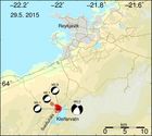
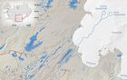
Earthquake sequence at Kleifarvatn
On 29 May at 13:10 an earthquake of magnitude 4.0 occurred under the northern part of Sveifluháls, close to lake Kleifarvatn on the Reykjanes peninsula. It was widely felt in the capital area and in Akranes.
Another magnitude 3.1 event was measured earlier the same day at 11:58 at the same location. Hypocenter depths of the earthquakes were around 3-4 km.
Read more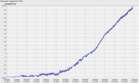
A minor jökulhlaup in river Gígjukvísl
A minor glacial outburst flood (jökulhlaup) is occurring in the river Gígjukvísl on Skeiðarársandur. The flood, which originates from subglacial lake Grímsvötn, became apparent on 6 May when the level of Gígjukvísl began to rise steadily.
Potentially hazardous levels of hydrogen sulphide gas could be present at the location where floodwater bursts from Skeiðarárjökull. In the immediate vicinity of the outlet, gas concentrations could be high enough to cause respiratory problems and even damage to eyesight. For travellers on Skeiðarársandur, the ongoing flood poses no hazards.
Read more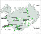
Bárðarbunga AVCC now green
IMO has changed the Aviation Colour Code for Bárðarbunga volcano from yellow to GREEN, as from 24 April 2015.
This decision has been taken in light of recent seismic and geodetic data from around the volcano, in addition to other measurements such as satellite-based thermal observations and radar-profiling flights.
Bárðarbunga continues to be monitored closely and any significant change in the volcano's state will be reported immediately.
Read more
The weather in Iceland 2014
The year 2014 was very warm, precipitation was abundant and the sunshine duration during most of the summer was considerably below average.
In spite of the high temperatures the weather was changeable and often dull.
The first months of the year were especially wet in the North and East and the weather was difficult. In the west it was very dry at the same time with favourable weather conditions.
The summer was warm and considered fine in the North and East but in the south it was very wet and dull.
The autumn was fine, November extraordinarily warm, but the year ended with an unruly and rather cold December.
Read more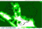
The solar eclipse 20 March
Friday 20 March 2015, an almost total solar eclipse will be seen from Iceland, such as has not been seen for 61 years. And it so happens, that this time, it will occur on equinox.
Clouds may impede the view. Check IMO's cloud cover forecasts, where white means clear skies, and adjust the scale underneath the map for correct timing (roughly between 08:30 and 10:40). The tabs above the map will show more selective forecasts for low, high or middle clouds.
People are strongly advised against looking at the sun without proper precaution. Even a glimpse towards the sun might cause irretrievable damage to the eyes.
The eruption has come to an end
The volcanic eruption in Holuhraun has come to an END. For the first time, no glow was seen in a flight 27 Feb.
Volcanic gas can still get dispersed all over the country; emission has not ended.
The lava field is now 85 km². The average thickness is at least 10 - 14 m (max 40 m) and the volume is about 1.4 km³.
The maximum subsidence of the caldera is at least 61 m and the rate was only 5 cm/day last week, compared to tens of centimetres earlier. The volume of the subsidence is 1.7 - 1.8 km³.
Conditions on the eruptive site are still dangerous. Gas emissions at the eruption site and from the lava field are still life threatening.
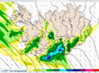
Severe weather, Saturday 14 March
A violent storm with hurricane-force wind gusts will occur tomorrow, Saturday 14 March. Intense rain and snow-melt is expected in the south- and southeast. Rising river levels are expected.
National warnings for wind, rain, hazardous flash floods, wet snow avalanches, slush flows and landslides are in effect.
The same weather warnings apply to Reykjavík and the surrounding area. Travel is exceptionally hazardous and people are advised to remain indoors; non-essential travel should be avoided.
Intense rainfall - possible floods and flows
Intense rainfall is expected in the south and south-east of the country, especially around Mýrdalsjökull and south of Vatnajökull, as well as nearby mountainous areas. A warning was issued yesterday.
Rapid melting of recently fallen snow could result in river and stream floods, slush flows, and, possibly, mud flows. Such extreme conditions occur every few years, so special care must be taken to avoid possible hazards.
Read more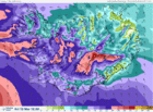
Gale increasing
A strong gale or severe gale warning (average wind velocity 20 to 28 m/s) is in effect for all parts of Iceland today.
Bad weather is expected late noon until night. Visibility will be poor because of snow and drifting snow. Bad travelling weather in mountain roads and even closed roads. The weather passes over the South and West parts in the evening, but near midnight in the east part.
Read more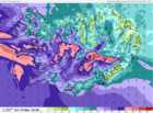
Warning - strong or severe gale
Bad weather is expected from noon tomorrow until late tomorrow evening and night. Visibility will be greatly diminished due to snow and blowing snow and travelling across mountain roads will be challenging, perhaps impossible. The weather will pass in the southwest between 19 and 21 UTC, but after midnight in the North and East.
Read more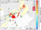
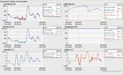
Comparison of displacement velocities for different time periods
The Bárðarbunga seismic- and volcanic events provide multitude of data, supporting various research.
Now, displacement velocities of GPS stations in the vicinity of Bárðarbunga over the past month, are compared with their displacement velocities from 21 September until today.
The date 21 September is chosen because by then, displacement velocities related to the propagation of the dyke have become negligible and large displacement signals around Bárðarbunga are solely due to the subsidence of the caldera.
Read more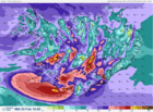
Warning - severe gale today
Bad weather is expected with poor travel conditions today and in the West tomorrow.
Increasing east wind with snow in the south- and west parts, but later sleet or rain by the coast, 18 to 28 m/s in the afternoon, strongest by the south coast. Lighter wind and light precipitation in the north and east parts at first, then 18 to 23 there and snow or blowing snow.
Considerably decreasing wind and precipitation by evening and tonight, but still strong gale in Vestfirðir. North 20 to 30 m/s and snow or snow showers in the western part tomorrow, strongest wind in Vestfirðir.
Read more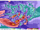
Warning - high winds
Bad weather is expected with poor travel conditions Wednesday 25 Feb., first in the south and west.
Northeast wind, 5 to 13 m/s and snow showers or some snow in most parts. Temperatures from 0 to minus 8 °C, coldest in the north. Becoming southeast and east 20 to 28 m/s in the south and west with snow or sleet, but later rain in the southernmost part. Lighter and mostly dry in the north and east, but increasing wind there in the afternoon with snow.
Temperatures slightly below zero, temperature near zero degrees in the south in the afternoon. Decreasing wind and precipitation tomorrow evening and night, least though in Vestfirðir, the West fjords.
Read more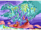
Warning - severe storm in the South on Sunday
Strong wind gusts (over 40 m/s) are expected near mountains in the south and southwest tonight and tomorrow. The worst weather will be in the South.
Strong winds with snow and snowdrift means that visibility will be little to none, and travelling is discouraged.
Even though there will be less precipitation in other parts, the wind will be enough to to move loose snow which is there already and form snowdrift and delay or inhibit travel.
On Monday it looks like strong northerly wind, and it does not look like the wind will moderate until Tuesday.
Read more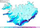
Warning against heavy rainfall
Heavy rainfall and mild conditions are forecast for west, south-west, south, and south-east Iceland on Saturday 14 February, lasting until late afternoon on Sunday.
It is advised to check drainage and keep it clear of leaves, rubbish, ice etc. in order to prevent water damage.
The southerlies that cause these changes may reach storm conditions (over 20 m/s) in West- and Northwest Iceland when rushing down from the mountains. They may also give rise to very sharp gusts of wind.
Rising stream- and river levels are expected on the Snæfellsnes peninsula, around the Eyjafjallajökull and Mýrdalsjökull ice caps, and south of the Vatnajökull ice-cap. Travellers are cautioned against fording rivers in these regions.
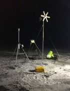
New equipment at Holuhraun
A MultiGAS gas measuring instrument and a weather station were installed near the Holuhraun eruption 22 January 2015.
Both instruments transmit data to IMO which will be used for monitoring the eruption. The data base which builds up, will help with forecasts of future eruptive activity.
The MultiGAS instrument is part of a collaboration with the University of Palermo, thanks to the FutureVolc project. The weather station is part of a collaboration with the British Geological Survey.
Read more
An ice surge at Jökulsá á Fjöllum
An ice surge is occurring on Jökulsá á Fjöllum at Grímsstaðir. The ice that had formed on the banks and the surface of the river has broken into many fragments, creating an icy, slow moving mixture. Water is beginning to seep over the main road, west of the bridge.
In addition to this news article, see a photo gallery from the bridge including updated satellite images and aerial photos from a surveillance flight.
As the break-up of snow and ice continues, it is possible that water could continue to leak across the road. If the discharge of Jökulsá á Fjöllum increases due to snow-melt or rainfall, then the level of flooding could be greater.
Read more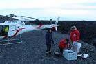
Monitoring device rescued from the lava
One of IMO's SO2 monitoring devices, which had been trapped by the Holuhraun lava flow since last year, was rescued on Saturday 10 January by staff from the Institute of Earth Sciences and Reykjavik Helicopters.
This instrument is part of the FutureVolc collaboration with IMO's partners at Chalmers University of Technology and the University of Applied Sciences in Dusseldorf.
Read moreSearch
Contact IMO
© Veðurstofa Íslands | Bústaðavegi 7- 9 | 105 Reykjavík | Phone 522 6000 | Fax: 522 6001
Recording 902 0600 | SSN 630908-0350
Contact us | Employees | Terms and conditions | Sitemap


