
News

New article on glacier changes in Iceland over the past 130 years
An article recently published in the journal Frontiers in Earth Science on glacier changes in Iceland describes changes in the volume and mass of the Icelandic glaciers since they reached historical maximum extent at the end of the so-called Little Ice Age shortly before 1900. The results of a number of studies covering about 99% of the glacier area are summarized in the article, which is a collaborative effort of many glaciologists at several institutes that conduct measurements and research on glaciers in Iceland.
Read more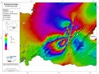
Significant ground deformation detected associated with recent earthquakes
Last week a series of earthquakes occurred on the Reykjanes Peninsula, between Fagradalsfjall and Kleifarvatn - the largest of which was a magnitude 5.6 earthquake in the vicinity of Núpshíðarháls, which occurred at 13:43 on 20th October. The maps displayed here show ground deformation associated with movement on faults during the period 16th-22nd October.
Read more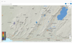
M5.6 at the Reykjanes peninsula
Seismic
activity has decreased significantly in recent days. About 180 earthquakes of
magnitude 2.2 or less were detected the last two days, for comparison, during
the first 24 hours following the 5.6 earthquake in Núpshlíðarháls, about 1700
earthquakes were detected in the area.
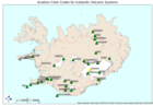
The Aviation Color Code for Grímsvötn changed from green to yellow
The Icelandic Met Office has changed the aviation color code for Grímsvötn volcano from green to yellow. Volcanic activity at Grímsvötn has been gradually increasing over time as indicated by several regularly monitored geophysical and geochemical parameters that are now above the known background level.
Read more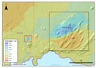
Update on the activity in the Reykjanes peninsula
Since the intense seismic swarm started in Fagradalsfjall on the 18th of July, the activity has been slowly decreasing over time. The acquisition of recent satellite images enabled mapping of new surface deformation in the area associated with the sequence of large earthquakes which occurred between the 18th and 20th of July. The satellite data processing clearly shows a deformation signal corresponding to approximately 3 centimeters of movement along a NE-SW oriented fault in the region of Fagradalsfjall.
Read more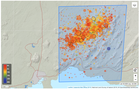
An earthquake swarm in Fagradalsfjall
On 19th July at approximately 01:30 a.m. a seismic swarm commenced in Fagradalsfjall. Over 1700 earthquakes have occurred in this region since. The largest event occurred at 23:36 yesterday evening with a magnitude (M) of 5. Two other events greater than M4 occurred early this morning at 05:46 (M4.6) and 06:23 (M4.3), respectively. In addition, 22 earthquakes greater than M3 have occurred since midnight. Felt earthquakes have been reported by local residents as far Akranes in the west and Vík in the east. The seismic swarm is still ongoing with similar intensity.
Read more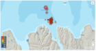
A strong earthquake swarm offshore North Iceland
A strong earthquake swarm started on 19th of June offshore North Iceland, NE of Siglufjörður. Three earthquakes above M5.0 have occurred since the swarm started. On 20th of June a M5.4 earthquake occurred at 15:05 and a M5.6 at 19:26. Both these earthquakes were located around 20 km NE of Siglufjörður. The largest earthquake of the swarm occurred on 21st of June at 19:07 and was M5.8.
Read more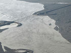
The Civil Protection Scientific Advisory Board meets to discuss the status of Grímsvötn
The meeting reviewed activity in Grímsvötn in the past months and discussed measurements made in and around Grímsvötn in early June. While seismic activity has been increasing over the past year, in June it was still lower than in the months leading up to the most recent eruptions in 2004 and 2011. Measurements of land deformation show that land continues to rise since the previous eruption with no significant changes in the last year. The biggest measurable change was that sulfur dioxide (SO2) was detected close to the last eruption site. SO2 emissions give a strong indication of magma degassing.
Read more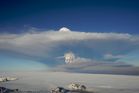
Evidences that Grímsvötn volcano is getting ready for the next eruption
During its active period, as it is since the eruption in 1996, Grímsvötn erupts on average each 5-10 years. The last eruption occurred in 2011 and it was a fairly large and powerful event. Between eruptions, the deformation data indicate the gradual accumulation of new magma at depth and the increased pressure in the system. In the last weeks scientists from the IMO measured SO2 in the southwest corner of the caldera in Grímsvötn, close to where the last eruptions in 2004 and 2011 took place.
Read more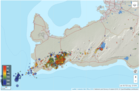
Seismic activity around Mt. Þorbjörn has decreasing significantly
In the beginning of April the uplift in Þorbjörn decreased and, in the second part of the month, it stopped. The area around Þorbjörn is now most likely recovering after the large induced stress, and the injected magma is cooling down and contracting. Along with reduced deformation, seismic activity has decreasing significantly. These data indicate that the injection of magma beneath Þorbjörn has stopped and this second phase of uplift due to magma intrusion can be considered closed. This data was presented during a Scientific Advisory Board, which met on 30th of April to discuss and review the current activity in Reykjanes Peninsula.
Read more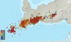
More research is needed to decipher the on-going activity at the Reykjanes Peninsula as a whole
On Thursday the 26th of March an on-line Scientific Advisory Board meeting was held to discuss the ongoing unrest in the Reykjanes peninsula. Scientists from IMO, University of Iceland, ISOR and representatives from Civil Protection, HS-Orka, ISAVIA-ANS, and the Environment Agency of Iceland attended the meeting.
Read more
Continued inflation around Mt. Þorbjörn
From the most recent crustal deformation measurements, it is now clear that the inflation that occurred in Þorbjörn in January-February has started again. This is confirmed by both GPS and satellite data Scientists from the Icelandic Met Office, University of Iceland and ISOR met Wednesday (18.03) to review the latest data. The deformation is occurring in the same location as before, but at a slower rate. The uplift started in January and halted temporarily at the end of February. The most recent data show that since the beginning of March the uplift is about 20 mm.
Read more
The weather in Iceland in 2019
The year 2019 was warm and the weather was mainly favorable. It was relatively warmer in the South and West but cooler in the North and East. April was exceptionally warm all over the country. It was the warmest April on record in Reykjavík, Stykkishólmur, Bolungarvík, Grímsey, Akureyri and Hveravellir.
The year was rather dry and particularly sunny in the southwestern and western part of the country. The year 2019 was the third sunniest year in Reykjavík on record. It was gloomier and wetter in the North and East. The year was one of the wettest years on record in Akureyri.
Read more
The Scientific Advisory Board meets to discuss the unrest at Mt. Thorbjörn in the Reykjanes peninsula
The data collected over the past week (including those measured by the recently installed stations) were reviewed. The new results suggest that the magma body is located at a depth of 3-5km, whereas it was previously estimated to be at 3-9km. There are indications of changing patterns in the crustal movements. The earthquake activity has decreased over the past two days, but there are still signs of a continuing inflation. Until now, the maximum deformation observed from the GPS stations is about 5 centimeters. Similar volcanic crises in the country suggest that this might be a long-term event, for which changes can occur week after week without the possibility to anticipate with certainty if the activity is resolved. During the meeting, possible scenarios that could be triggered in the event of an eruption have been also considered.
Read more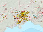
Possible magma accumulation beneath Mt. Thorbjorn on Reykjanes peninsula
An inflation has been detected since January 21st and is centred just west of Mt. Thorbjorn on Reykjanes peninsula. The inflation is unusually rapid, around 3-4 mm per day and has accumulated to 2 cm to date. It has been detected both on continuous GPS stations and in InSAR images. The inflation is most likely a sign of magma accumulation at a depth of just a few km. If magma accumulation is causing the inflation, the accumulation is very small, with the first volume estimate is around 1 million cubic meters (0,001 km3). This is the conclusion of a meeting held with the Scientific council of the Civil Protection at the IMO this morning.
Read moreSearch
Contact IMO
© Veðurstofa Íslands | Bústaðavegi 7- 9 | 105 Reykjavík | Phone 522 6000 | Fax: 522 6001
Recording 902 0600 | SSN 630908-0350
Contact us | Employees | Terms and conditions | Sitemap


